
August 2017: Looking Back at Harvey 5 Year Later
Driving there may not even be an option tomorrow. If the euro and 6z gfs continues to show a ri cycle then it isnt far fetched that they call for evacs.djjordan wrote:Driving there would probably be ok ... but she will undoubtedly run into problems this weekend and the trip back will likely not be able to happen. Best course of action is not to go!!!!tgal wrote:Portland, Tx where the hurricane is headed
-
TexasBreeze
- Posts: 943
- Joined: Sun Sep 26, 2010 4:46 pm
- Location: NW Houston, TX
- Contact:
What is your opinion of it actually bombing out? Gfs Shows it meandering around Matagorda bay for awhile. 20+ inches around Houston.
Last edited by TexasBreeze on Wed Aug 23, 2017 11:20 pm, edited 2 times in total.

You are correct.... as I typed and posted that I looked at the latest GFS!!! Needless to say, Harvey looked pretty mean!!!Scott747 wrote:Driving there may not even be an option tomorrow. If the euro and 6z gfs continues to show a ri cycle then it isnt far fetched that they call for evacs.djjordan wrote:Driving there would probably be ok ... but she will undoubtedly run into problems this weekend and the trip back will likely not be able to happen. Best course of action is not to go!!!!tgal wrote:Portland, Tx where the hurricane is headed
BTW.... Air Force Reconnaissance has found TS winds and Harvey is now a Tropical Storm.
~~~When Thunder Roars Go Indoors~~~
~~~Turn Around Don't Drown~~~
~~~Run From The Water, Hide From The Wind~~~
~~~Turn Around Don't Drown~~~
~~~Run From The Water, Hide From The Wind~~~
Yep. We have Tropical Storm Harvey now.
Thank all of you so very much. I have a very disappointed daughter but you helped. As of now she is going to call it off. I hope they do call for evacuations because I am worried about her family that is down there.
Again, I really appreciate your help
Again, I really appreciate your help

This is at 1st landfall?mcheer23 wrote:CMC is coming in further north
-
mcheer23
- Pro Met

- Posts: 536
- Joined: Fri Jan 11, 2013 11:15 am
- Location: Missouri City/ Sugar Land
- Contact:
Rip76 wrote:This is at 1st landfall?mcheer23 wrote:CMC is coming in further north
CMC only has one landfall.
GFS has 2, GFS actually has my area (Sugar Land) getting about 28 inches of rain on the 00z
Ok, I'm in Pearland. Not that far away.mcheer23 wrote:Rip76 wrote:This is at 1st landfall?mcheer23 wrote:CMC is coming in further north
CMC only has one landfall.
GFS has 2, GFS actually has my area (Sugar Land) getting about 28 inches of rain on the 00z
Can someone post a map of rainfall totals from the GFS Oz run?
-
Andrew
- Site Admin

- Posts: 3440
- Joined: Wed Feb 03, 2010 9:46 pm
- Location: North-West Houston
- Contact:
I was hoping the southwest movement after landfall would gain more traction. That would decrease rain here substantially. Unfortunately with the GFS moving to the northeast again the ECMWF may be on track for some serious flooding here late over the weekend into early next week.
For Your Infinite Source For All Things Weather Visit Our Facebook
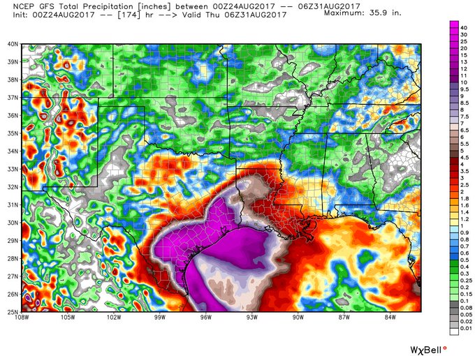
James Spann just tweeted this Precip map!!! GFS total precip!!!
~~~When Thunder Roars Go Indoors~~~
~~~Turn Around Don't Drown~~~
~~~Run From The Water, Hide From The Wind~~~
~~~Turn Around Don't Drown~~~
~~~Run From The Water, Hide From The Wind~~~
Another NOAA mission is already up and forgot to mention there is a global hawk flying as well. Combine that with the late stages of the current recon mission and it's safe to say all hands are on deck. Any hiccups with track and 6z runs will pick up on it.
-
Andrew
- Site Admin
- Posts: 3440
- Joined: Wed Feb 03, 2010 9:46 pm
- Location: North-West Houston
- Contact:
Think we are starting to get a pretty good consensus. Only thing I think might happen as time goes on is a slightly more north track as models trend towards a stronger storm.Scott747 wrote:Another NOAA mission is already up and forgot to mention there is a global hawk flying as well. Combine that with the late stages of the current recon mission and it's safe to say all hands are on deck. Any hiccups with track and 6z runs will pick up on it.
I actually think the UKMET plot is pretty good (USTropics from Storm2k posted this):
For Your Infinite Source For All Things Weather Visit Our Facebook
-
brooksgarner

- Global Moderator

- Posts: 226
- Joined: Tue Jun 04, 2013 3:06 pm
- Location: Houston, TX
- Contact:
Jeesh. That 00z GFS...
Keep in mind that accumulations happen over 3-6 days, but still... rivers/bayous, oh my.
Keep in mind that accumulations happen over 3-6 days, but still... rivers/bayous, oh my.
Broadcast Met
http://BrooksGarner.com
http://twitter.com/BrooksWeather
http://BrooksGarner.com
http://twitter.com/BrooksWeather
- '17 Harvey
- '12 Sandy (P3 Orion)
- '91 Bob
- '85 Gloria
The UKMet seems reasonable.
Looks like the center is moving up towards the convection per recon.. that may move the track further N and E as time goes on. That map above from USTropics posting the UKMET plots is certainly plausible. What a headache...
Agree Andrew. In fact the noaa mission may be showing that the center has reformed further n closer to the deep convection.
-
Andrew
- Site Admin
- Posts: 3440
- Joined: Wed Feb 03, 2010 9:46 pm
- Location: North-West Houston
- Contact:
brooksgarner wrote:Jeesh. That 00z GFS...
Keep in mind that accumulations happen over 3-6 days, but still... rivers/bayous, oh my.
There is also a period where it shows ~8 inches in 6 hours. Obviously that will change but shows that fast accumulations will happen.
For Your Infinite Source For All Things Weather Visit Our Facebook
-
- Information
-
Who is online
Users browsing this forum: Ahrefs [Bot], jasons2k, Pas_Bon, tireman4 and 8 guests