Hurricane Alex. 40 Miles NNE of La Pesca. 100 MPH/948MB

Tropical Weather Discussions and Analysis
User avatar
srainhoutx
Site Admin
Site Admin
Posts: 19616
Joined: Tue Feb 02, 2010 2:32 pm
Location: Maggie Valley, NC
Contact:

Maybe some updated data...

Code: Select all

8 
WHXX01 KWBC 260028
CHGHUR
TROPICAL CYCLONE GUIDANCE MESSAGE
NWS TPC/NATIONAL HURRICANE CENTER MIAMI FL
0028 UTC SAT JUN 26 2010

DISCLAIMER...NUMERICAL MODELS ARE SUBJECT TO LARGE ERRORS.
PLEASE REFER TO NHC OFFICIAL FORECASTS FOR TROPICAL CYCLONE
AND SUBTROPICAL CYCLONE INFORMATION.

ATLANTIC OBJECTIVE AIDS FOR

TROPICAL CYCLONE ONE (AL012010) 20100626 0000 UTC

...00 HRS... ...12 HRS... ...24 HRS. .. ...36 HRS...
100626 0000 100626 1200 100627 0000 100627 1200

LAT LON LAT LON LAT LON LAT LON
BAMS 16.6N 83.9W 17.7N 86.0W 19.0N 87.8W 20.2N 89.6W
BAMD 16.6N 83.9W 17.1N 85.9W 17.9N 87.8W 18.7N 89.4W
BAMM 16.6N 83.9W 17.4N 85.9W 18.2N 87.8W 19.2N 89.6W
LBAR 16.6N 83.9W 17.1N 86.0W 18.1N 88.1W 19.2N 90.1W
SHIP 30KTS 38KTS 49KTS 56KTS
DSHP 30KTS 38KTS 49KTS 34KTS

...48 HRS... ...72 HRS... ...96 HRS. .. ..120 HRS...
100628 0000 100629 0000 100630 0000 100701 0000

LAT LON LAT LON LAT LON LAT LON
BAMS 21.4N 91.0W 23.3N 93.3W 24.2N 95.1W 24.3N 96.5W
BAMD 19.6N 90.7W 21.1N 92.6W 22.2N 95.0W 23.0N 97.3W
BAMM 20.4N 91.0W 21.8N 93.0W 22.8N 95.1W 23.1N 97.2W
LBAR 20.6N 91.9W 23.9N 94.2W 27.7N 95.9W 31.6N 94.9W
SHIP 64KTS 73KTS 77KTS 75KTS
DSHP 36KTS 45KTS 48KTS 47KTS

...INITIAL CONDITIONS...
LATCUR = 16.6N LONCUR = 83.9W DIRCUR = 295DEG SPDCUR = 7KT
LATM12 = 16.1N LONM12 = 82.5W DIRM12 = 293DEG SPDM12 = 5KT
LATM24 = 16.0N LONM24 = 81.6W
WNDCUR = 30KT RMAXWD = 100NM WNDM12 = 30KT
CENPRS = 1004MB OUTPRS = 1008MB OUTRAD = 170NM SDEPTH = M
RD34NE = 0NM RD34SE = 0NM RD34SW = 0NM RD34NW = 0NM
Image
Carla/Alicia/Jerry(In The Eye)/Michelle/Charley/Ivan/Dennis/Katrina/Rita/Wilma/Humberto/Ike/Harvey

Member: National Weather Association
Facebook.com/Weather Infinity
Twitter @WeatherInfinity
User avatar
Paul
Posts: 535
Joined: Wed Feb 03, 2010 11:46 pm
Location: Pearland
Contact:

I am going to stick with the Dynamic models and not some much the BAMMS over 20N.....I am smelling a shift with the EURO tonight...and it aint left...
User avatar
Ptarmigan
Statistical Specialist
Posts: 4001
Joined: Wed Feb 03, 2010 7:20 pm
Contact:

TD1 is quite large. Reminds me of Tropical Storm Frances in 1998. That was a large storm right there! Also, it looked like a monsoonal low.
User avatar
desiredwxgd
Posts: 125
Joined: Wed Feb 03, 2010 6:30 pm
Location: TX/LA/Southern New England
Contact:

Paul wrote:I am going to stick with the Dynamic models and not some much the BAMMS over 20N.....I am smelling a shift with the EURO tonight...and it aint left...

LOL ok then. If not left then right, but right where?
JMS
SR. ENSC.
texaskaz
Posts: 32
Joined: Sat Feb 06, 2010 10:24 pm
Contact:

I learned lesson...I started filling up my cars last night and bought some water. Filling up empty bottles to put in freezer.
User avatar
wxman57
Global Moderator
Global Moderator
Posts: 2621
Joined: Thu Feb 04, 2010 5:34 am
Location: Southwest Houston (Westbury)
Contact:

NHC track is in the middle of the road between the most likely track (NE Mexico) and a slight chance (northern Gulf coast). So it's guaranteed to be wrong. We went well west of NHC track and a lot faster, taking it inland about 100 miles south of Brownsville Wednesday afternoon (at 120hrs). May have to shift that farther south with time, maybe closer to Tampico. Building ridge along the Gulf Coast should turn it westward. Trof well to the north looks too weak to pick it up.
User avatar
Paul
Posts: 535
Joined: Wed Feb 03, 2010 11:46 pm
Location: Pearland
Contact:

desiredwxgd wrote:
Paul wrote:I am going to stick with the Dynamic models and not some much the BAMMS over 20N.....I am smelling a shift with the EURO tonight...and it aint left...

LOL ok then. If not left then right, but right where?

aks me again at 1:30am... ;)


food for thought...


http://www.aoml.noaa.gov/phod/dataphod1 ... 5atd26.png

http://wxmaps.org/pix/hurpot.html#ATL
User avatar
Paul
Posts: 535
Joined: Wed Feb 03, 2010 11:46 pm
Location: Pearland
Contact:

wxman57 wrote:NHC track is in the middle of the road between the most likely track (NE Mexico) and a slight chance (northern Gulf coast). So it's guaranteed to be wrong. We went well west of NHC track and a lot faster, taking it inland about 100 miles south of Brownsville Wednesday afternoon (at 120hrs). May have to shift that farther south with time, maybe closer to Tampico. Building ridge along the Gulf Coast should turn it westward. Trof well to the north looks too weak to pick it up.

Except for the EURO the GFS has been talking monster FROPA all the way to mid- FL....but it is June so I will stick to the EURO for now unless I see a change tonight....
User avatar
srainhoutx
Site Admin
Site Admin
Posts: 19616
Joined: Tue Feb 02, 2010 2:32 pm
Location: Maggie Valley, NC
Contact:

Thanks for the update wxman57.
Carla/Alicia/Jerry(In The Eye)/Michelle/Charley/Ivan/Dennis/Katrina/Rita/Wilma/Humberto/Ike/Harvey

Member: National Weather Association
Facebook.com/Weather Infinity
Twitter @WeatherInfinity
ticka1
Posts: 1265
Joined: Wed Feb 03, 2010 3:02 pm
Location: Baytown/Mont Belvieu
Contact:

No upgrade - the NHC shifted its cone to the west some:

Image
LylaB
Posts: 6
Joined: Fri Jun 25, 2010 9:54 pm
Location: Hockley
Contact:

Hi guys! As a serial lurker and before things get crazy on here, I want to thank you all in advance for all the well informed information you put out there. I have been here since before Rita and so appreciate your knowledge and info that you guys share. I will constantly be looking on here for your insights and riding out whatever storm this season brings us! Thanks! :)
HereInKaty
Posts: 7
Joined: Thu Jun 03, 2010 5:05 pm
Contact:

hey, great to see everyone posting! wonderful info as usual! love you guys. i've been lurking so far this season. and i lurked with all the cold fronts and snow this past winter as well.
just got a brand new jeep today and they told me i can't switch my insurance when there is a hurricane in the gulf! i told them i'd have to hurry.. i'm sure they'll understand my joke when they see the 10pm news :)

Cathereine
sleetstorm
Posts: 651
Joined: Thu Feb 04, 2010 12:33 pm
Contact:

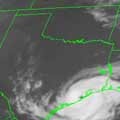
Well, how about this, our first tropical depression of the 2010 hurricane season. ;) :P I think that it cetainly could stregthen to tropical storm status sometime tonight or tomorrow. I tell you that is one large depression.
User avatar
msp
Posts: 30
Joined: Fri May 14, 2010 9:02 pm
Location: Houston, TX
Contact:

that main plume is weakening now. the best convection is clearly concentrated to the northeast with a few smaller towers springing up around the old "core's" fringes.
Last edited by msp on Fri Jun 25, 2010 11:03 pm, edited 1 time in total.
txsnowmaker
Posts: 632
Joined: Wed Feb 03, 2010 4:07 pm
Location: SW Houston (Galleria area)
Contact:

msp wrote:that main plume is weakening now. the best convection is clearly concentrated to the northeast with a few smaller towers springing up around the old core's fringes.

Perhaps this is what wxman57 was referring to when he said to pay attention to what was following this system?
Andrew
Site Admin
Site Admin
Posts: 3440
Joined: Wed Feb 03, 2010 9:46 pm
Location: North-West Houston
Contact:

msp wrote:that main plume is weakening now. the best convection is clearly concentrated to the northeast with a few smaller towers springing up around the old core's fringes.

It is possible that the center is reforming more to the North-East.
For Your Infinite Source For All Things Weather Visit Our Facebook
sleetstorm
Posts: 651
Joined: Thu Feb 04, 2010 12:33 pm
Contact:

It does not look like Tropical Depression 1 is moving northwest or even west-northwest at all.
User avatar
msp
Posts: 30
Joined: Fri May 14, 2010 9:02 pm
Location: Houston, TX
Contact:

recon will give us info soon enough, but i'm real curious as to where the CoC is now in relation to that new convective burst.
User avatar
Mr. T
Posts: 992
Joined: Wed Feb 03, 2010 4:22 pm
Location: Kingwood
Contact:

I'm not even going to attempt to decipher the 0z GFS, except it gives us a lot of rain next week after Alex dives into a Mexico and some kind of vorticity is left over in the Gulf that heads towards the Upper Texas Coast.
User avatar
Paul
Posts: 535
Joined: Wed Feb 03, 2010 11:46 pm
Location: Pearland
Contact:

yeah the GFS is jacked up again....but it still shows that dang trof digging pretty deep....is it ever going to back off on that solution...sheesh...
Post Reply
  • Information
  • Who is online

    Users browsing this forum: No registered users and 61 guests