
OCTOBER 2018 - Stormy Halloween
Glad I left for Kentucky. Although it's sunny in Houston, I don't want 80 degree weather again this year

Unfortunately, the cold front is now predicted to arrive Halloween night. Hope the rain and t-storms hold off until midnight or later.
-
MontgomeryCoWx

- Posts: 2356
- Joined: Wed Dec 14, 2011 4:31 pm
- Location: Weimar, TX
- Contact:
Ready for the next front. It feels nasty outside.
Team #NeverSummer
Where are the cool fall temperatures?
-
CrashTestDummy
- Posts: 187
- Joined: Mon Jul 25, 2016 3:44 pm
- Location: Pearland, Texas
- Contact:
These ARE them.Karen wrote:Where are the cool fall temperatures?
Gene Beaird,
Pearland, Texas
"You can learn a lot from a Dummy."
Pearland, Texas
"You can learn a lot from a Dummy."
-
Katdaddy

- Global Moderator

- Posts: 2502
- Joined: Thu Feb 04, 2010 8:18 am
- Location: League City, Tx
- Contact:
Areas of fog across portions of SE TX again this morning. Moisture begins to increase across SE TX ahead of the next cold front to arrive Wednesday. The SPC has a slight risk area across E and SE TX and E LA for Wednesday. Timing will be critical for trick or treating.
- Attachments
-
- Screen Shot 2018-10-29 at 5.17.32 AM.png (18.12 KiB) Viewed 3871 times
You must have just moved here...LOL....This is as good as it gets for S.E. Tx this time of year, until December..then maybe, if we're lucky, we'll see some cooler/colder weatherKaren wrote:Where are the cool fall temperatures?
-
srainhoutx

- Site Admin

- Posts: 19616
- Joined: Tue Feb 02, 2010 2:32 pm
- Location: Maggie Valley, NC
- Contact:
Monday morning briefing from Jeff:
A storm system will approach and move across the area on Wednesday with a chance of severe thunderstorms.
High pressure is starting to move eastward which will allow moisture to begin to return across the region today and especially tomorrow ahead of a cold frontal passage late Wednesday. SE winds will increase on Tuesday as high pressure moves toward the east coast allowing a fairly dry air mass to quickly moisten with PWS by Wednesday afternoon reaching near 2.0 inches. Air mass will begin to destabilize with heating on Wednesday as jet stream dynamics become increasingly favorable for upward motion over the area. Appears warm sector air mass will remain somewhat capped into the mid to late afternoon hours, but approach and linear forcing along a cold front should develop a line of thunderstorms that crosses the area between 400pm and midnight on Wednesday. Still some timing differences in the models but the period form late afternoon into the late evening is looking fairly stormy.
SPC has outlooked the entire area for a severe risk with main threats being damaging winds and large hail. Instability profiles are looking better today than yesterday for much of the area and SE TX will be in a favorable potion of the jet stream for significant lift so expect some string to severe storms. Linear forcing along the front will likely produce more of a squall line type feature with damaging straight line winds likely the biggest threat. Tornado threat appears low unless discrete cells can form in the warm sector ahead of the main squall line.
A strong cold front will sweep across the region late Wednesday evening ushering in another fairly cool late October air mass. Lows well into the 50’s and highs in the 60’s and 70’s for late this week into next weekend under generally sunny skies.
Day 3 (Wednesday) Severe Weather Outlook:
- Attachments
-
Carla/Alicia/Jerry(In The Eye)/Michelle/Charley/Ivan/Dennis/Katrina/Rita/Wilma/Humberto/Ike/Harvey
Member: National Weather Association
Facebook.com/Weather Infinity
Twitter @WeatherInfinity
Member: National Weather Association
Facebook.com/Weather Infinity
Twitter @WeatherInfinity
-
tireman4

- Global Moderator
- Posts: 4496
- Joined: Wed Feb 03, 2010 9:24 pm
- Location: Humble, Texas
- Contact:
000
FXUS64 KHGX 291752
AFDHGX
Area Forecast Discussion
National Weather Service Houston/Galveston TX
1252 PM CDT Mon Oct 29 2018
.AVIATION...
Cumulus deck forming within a warmed and slightly more moist air
mass moving in from the west southwest. Status quo through the
period with a lessened threat for dense fog Tuesday morning. While
there may still be pockets of fog over more wind-protected
terminals, feel that a strengthened onshore flow brought on by
deepening western Texas troughing should provide enough lower
level mixing to maintain low (MVFR) stratus. Low near sunrise MVFR
deck formation with a lift out to VFR by 10 AM under more moderate
southerlies. 31
&&
.PREV DISCUSSION... /ISSUED 1112 AM CDT Mon Oct 29 2018/
UPDATE...
Forecast is on track. Most of the widespread fog has dissipated
but some very light fog continues over the northernmost counties
but will burn off within the hour. The Dense Fog Advisory was
allowed to expire at 10 AM CDT this morning.
Mostly sunny skies with temperatures ranging from the upper 60s
to upper 70s are expected during the morning hours...reaching up
to the mid 80s in the afternoon. Winds will generally be from the
south southwest at 5-10 MPH with some occasional gusts. 24
PREV DISCUSSION... /ISSUED 355 AM CDT Mon Oct 29 2018/
DISCUSSION...
Ongoing forecast and reasoning remains about the same and just
minor tweaks were made. Foggy conditions currently persist across
the sw 1/3 of the CWA and a Dense Fog Advisory remains in effect.
This advisory will likely need to be expanded north and east, possibly
into the metro area, in the next couple hours. Improving visibilities
are expected as we head into the mid morning hours. Remainder of
the day looks similar to yesterday with dry and warm conditions
prevailing. Same general scenario for tonight/tomorrow too.
As ridging edges east, onshore winds will begin transporting deeper
Gulf moisture back inland ahead of the next cold front still expected
on Halloween. Model guidance is showing a bit more atmospheric instability
than what we were looking at this time yesterday. Also still noted
is a coupled jet structure situated over the the region putting a
good portion of se Tx in the favorable RRQ/LFQ region during the
late afternoon and evening hours. So the potential for some strong/severe
storms looks to be possible -- more than likely in the form of a
line of convection developing along the front. This system looks
progressive, so flooding concerns will probably be more of the
form of localized urban street flooding whereas a few inches of
rain falls in a short period. At this time, it appears the most
favorable window of significant wx will be in the 4pm-midnight
timeframe, unfortunately. That being said, things can always
change between now and then and simple 6-8 hour time shifts could
make a difference for trick-or-treating...
Drier, cooler wx will move in behind the front Thursday and
continue into the weekend. 47
MARINE...
Light south winds will prevail today...with speeds picking up later
this afternoon/tonight as the surface pressure gradient tightens in
response to lowering pressures across the Southern Plains. SCEC
conditions are likely for the coastal waters Tues and Weds. There
will be a chance of showers/thunderstorms Weds with thunderstorms
likely Weds night as a cold front moves across the marine waters.
Moderate to strong offshore flow is expected in the wake of this
front Thurs with SCEC/SCA flags possible. These northerly winds
should decrease Thurs night/Fri. 41
&&
.PRELIMINARY POINT TEMPS/POPS...
College Station (CLL) 65 83 69 80 53 / 0 0 10 70 60
Houston (IAH) 66 84 70 84 57 / 0 10 10 50 80
Galveston (GLS) 72 80 74 81 60 / 0 10 10 40 80
&&
.HGX WATCHES/WARNINGS/ADVISORIES...
TX...NONE.
GM...NONE.
&&
$$
Discussion...24
Aviation/Marine...31
-
Texaspirate11

- Posts: 1278
- Joined: Tue Dec 31, 2013 12:24 am
- Contact:
IT WAS A DARK & STORMY NIGHT...
PERFECT FOR HALLOWEEN......................
PERFECT FOR HALLOWEEN......................
Just because you're disabled, you don't have to be a victim
Be Weather Aware & Prepared!
Barbara Jordan Winner in Media
Disability Integration Consultant
Be Weather Aware & Prepared!
Barbara Jordan Winner in Media
Disability Integration Consultant
-
Katdaddy
- Global Moderator
- Posts: 2502
- Joined: Thu Feb 04, 2010 8:18 am
- Location: League City, Tx
- Contact:
A warm day across SE TX with temps in the mid 80s and gusty S winds as moisture returns ahead of tomorrow’s cold front. Severe thunderstorms with heavy rain will be likely as the front pushes through SE TX tomorrow night. The SPC now has a large portion of SE TX including Houston in an enhanced risk area for severe thunderstorms tomorrow afternoon and tomorrow night. More beautiful cool weather to follow the front through Saturday with highs in the 70s and low in the 50s.
- Attachments
-
- Screen Shot 2018-10-30 at 5.29.12 AM.png (19.38 KiB) Viewed 3877 times
When are things going to get interesting with colder weather? Not talking about a day or 2 in the 50's and then gone....I mean real stuff.

The "real" cold air (low 40's 30's) doesn't usually start until the middle to end of November.
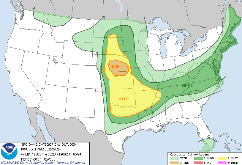
Day 2 Convective Outlook
NWS Storm Prediction Center Norman OK
1226 PM CDT Tue Oct 30 2018
Valid 311200Z - 011200Z
...THERE IS AN ENHANCED RISK OF SEVERE THUNDERSTORMS FROM SOUTHEAST
TEXAS TO THE LOWER MS VALLEY...
...SUMMARY...
Severe thunderstorms, primarily capable of damaging winds and a few
tornadoes, will be possible from southeast Texas to the lower
Mississippi Valley Wednesday evening into the overnight. Elsewhere,
a few severe storms capable of large hail will be possible near the
Edwards Plateau Wednesday afternoon/evening.
...Texas to the Lower Mississippi Valley...
The large-scale pattern will continue to amplify on Wednesday in
response to the interaction of a sharp shortwave trough moving into
west Texas and a secondary mid-level impulse dropping southeast
across the Rockies. As this occurs, southwesterly 500mb flow will
increase from east Texas to Mississippi through the overnight. A
low-level jet will correspondingly intensify from the upper Texas
coast to the Ohio Valley, with a corridor of at least 50-60 kt
south/southwesterly winds at 850 mb. Along the western edge of a
surface ridge centered over the southeast US coast, increasing
boundary-layer moisture will stream northward across the western
Gulf, southern Plains, and Mississippi Valley.
Convection will likely be ongoing across parts of central/northern
Texas Wednesday morning, generally located near/north of an
effective cold front stretching from the Big Country northeastward
to the Arklatex. These cells may be capable of isolated marginally
severe hail, but should mostly be sub-severe. Through the afternoon,
the effective front is forecast to drive southward across central
Texas. While the pre-frontal environment in this area will be
conditionally favorable for all severe hazards, deep-layer shear
vectors suggest most cells will be undercut by the front, limiting
the wind/tornado potential. Therefore, the Enhanced risk has been
contracted some here. Conversely, the Slight risk has been expanded
westward towards the Edwards Plateau, where the primary shortwave
trough and strong effective shear may encourage a few elevated
storms capable of large hail during the afternoon and evening.
The highest potential for impactful severe weather will likely exist
from southeast Texas towards the lower Mississippi Valley during the
evening and overnight. In conjunction with the aforementioned
low-level jet, channels of warm/moist low-level confluence streaming
north off the Gulf will probably encourage discrete development
ahead of a southwest/northeast-oriented line of strong/severe storms
moving east across the Sabine Valley during the evening. Forecast
soundings indicate ample low-level shear for stronger circulations
within both discrete/line-embedded supercells and QLCS structures,
with this potential likely maximized across portions of
western/central Louisiana and western Mississippi. Although
instability will be modest, enough low-level CAPE should be
available for a threat of tornadoes (a couple of which could be
strong) and damaging winds, especially considering surface dew
points in the upper 60s/lower 70s. Indeed, HREF guidance indicates
high probabilities of at least 500 J/kg of surface-based CAPE
extending to the Mississippi Delta. Considering this fairly
consistent signal from large-scale and hi-res guidance, the
Enhanced/Slight risks have been expanded eastward for a nocturnal
threat of tornadoes and damaging winds.
-
CRASHWX

- Posts: 266
- Joined: Thu Sep 13, 2018 2:33 pm
- Location: Hardin County / North of Beaumont
- Contact:
I’m a Joe Bastardi WeatherBell watcher...the free public stuff...he is bullish on a tough winter all the way to south Texas...our are with-3 to -5 temp annomolies and 167% of normal snowfall potential. Interestingly enough he points out he has been on this for months in face of the major models screaming much the opposite and now the major models are coming into line with the WeatherBell Forcast for winter 2018-2019. Any thoughts on this...?
You can also go on YouTube and look up 2018-2019 winter weather forecast and you will find many winter forecasts for this coming winter. They’re all mainly biased towards the east coast though.CRASHWX wrote:I’m a Joe Bastardi WeatherBell watcher...the free public stuff...he is bullish on a tough winter all the way to south Texas...our are with-3 to -5 temp annomolies and 167% of normal snowfall potential. Interestingly enough he points out he has been on this for months in face of the major models screaming much the opposite and now the major models are coming into line with the WeatherBell Forcast for winter 2018-2019. Any thoughts on this...?
-
srainhoutx
- Site Admin
- Posts: 19616
- Joined: Tue Feb 02, 2010 2:32 pm
- Location: Maggie Valley, NC
- Contact:
Tuesday afternoon briefing from Jeff:
Severe Thunderstorms possible across SE TX Wednesday afternoon and evening.
A strong trough and cold front combo will move across SE TX Wednesday afternoon into Thursday morning. Moisture advection from the Gulf of Mexico is underway and will increase into Wednesday as surface pressure begin to fall across the southern plains. Amplification of the upper level pattern will support the southward movement of a cold front into TX on Wednesday. Air mass over SE TX will become increasingly unstable during the day on Wednesday with heating and forecasted afternoon temperatures are expected to exceed convective/trigger temperatures. Short range and high resolution models show the development of scattered showers and thunderstorms well ahead of the actual frontal boundary Wednesday afternoon from roughly 200-600pm as surface temperatures warm into the mid 80’s. These showers and storms will be fairly fast moving, but could pose a small severe threat with gusty winds.
Timing of the actual frontal convective event has pushed back a few hours…and there may be a very narrow window from 500-800pm where much of SE TX is in a break before the onset of strong forcing and numerous thunderstorms along the front. Air mass over the warm sector from 500-800pm will remain moist and unstable and cannot rule out passing showers or even thunderstorms, but it appears the bulk of the weather may hold off until the mid evening hours. There is still some uncertainty on how quickly the cold front approaches on Wednesday afternoon/evening as any surface cold pool could drive the front faster to the south and speed up the arrival of thunderstorms.
Severe threat will increase through the evening hours on Wednesday with strong lift coming to bear across the region. Main threat will be damaging winds and isolated tornadoes especially along and N of I-10. SPC has increased the severe risk into an “enhanced risk” or on a scale from 1-5 a 2 for severe threats on Wednesday evening. Overall think the main severe threat will be damaging wind potential in a developing squall line and along any bowing segments with that line.
Front and associated weather will sweep out of the area by daybreak on Thursday with cold air advection in full swing. Expect temperatures on Thursday to hold in the 60’s with gusty NW winds and fall into the upper 40’s by Friday morning. Calm conditions and clear skies into Saturday will continue the cool weather with lows in the 50’s and highs in the low 70’s.
Severe Weather Threat (Wednesday):
- Attachments
-
Carla/Alicia/Jerry(In The Eye)/Michelle/Charley/Ivan/Dennis/Katrina/Rita/Wilma/Humberto/Ike/Harvey
Member: National Weather Association
Facebook.com/Weather Infinity
Twitter @WeatherInfinity
Member: National Weather Association
Facebook.com/Weather Infinity
Twitter @WeatherInfinity
Today’s 12z Euro is really wet for the Houston area. It shows 3.5 to 4.5” of rain over Harris County for the next 10 days with most of that coming tomorrow.