Page 7 of 32
Re: September 2023
Posted: Mon Sep 04, 2023 10:23 pm
by Stratton20
I dont know whats more embarrassing, the fact that its 90 degrees here at 10 or Clemsons epic meltdown vs duke

Re: September 2023
Posted: Mon Sep 04, 2023 10:28 pm
by Cpv17
Stratton20 wrote: ↑Mon Sep 04, 2023 10:23 pm
I dont know whats more embarrassing, the fact that its 90 degrees here at 10 or Clemsons epic meltdown vs duke
Two fumbles inside the 10 yard line and two missed field goals. Sloppy sloppy sloppy.
Re: September 2023
Posted: Mon Sep 04, 2023 10:33 pm
by Stratton20
Cpv17 and add a pick to that

Re: September 2023
Posted: Mon Sep 04, 2023 10:35 pm
by user:null
Cromagnum wrote: ↑Mon Sep 04, 2023 7:21 pm
It's WAY too dry for any of the scattered few areas to contribute anything at all to surrounding areas that didn't get anything. A foot of rain could fall and most of the land would look dry in a single day.
Cpv17 wrote: ↑Mon Sep 04, 2023 7:27 pmI think if that happened most of it would be runoff because the ground is too hard and it wouldn’t be able to sink in.
It's more specifically about the greater storm coverage in the Lufkin/Piney Woods area eastward into areas of Louisiana today. That would aid a pretty sizable area, especially factoring in how forested those areas are (and the resultant implications on transpiration and resultant atmospheric moisture, heating potentials, etc).
If the response to the rains are ideal, then the "surface low feature" showing up on modelling in North Texas/Oklahoma during this coming Thursday/Friday will be restricted from expanding eastward (due to lower high temps), making it easier for the "boundary" to drop into SE Texas this coming Saturday and bring further rain chances (as opposed to it being deflected east/delayed).
The previous GFS runs had a much stronger "surface low" and kept shunting this Saturday's rain chances eastward compared to CMC/EURO/ICON. As of the latest 18z, the GFS came more in line with the other models for showing better rain chances here this coming Saturday (due to aforementioned factors).
Regarding "ground hardness," heavy clays are just problematic soils in general: though the Piney Woods acidic "ultisols" based on kaolinite are the lesser of evils compared to the smectite "vertisols" found on the Texas Gulf and Blackland Prairies. On the other hand, sandy/siltier soils might allow more infiltration regardless of rainfall rate.
Regardless of what happens, there's still great chances for the "Death Ridge" to finally meet it's demise once and for all.

Re: September 2023
Posted: Mon Sep 04, 2023 10:57 pm
by DoctorMu
MontgomeryCoWx wrote: ↑Mon Sep 04, 2023 10:06 pm
Oh hey Duke Fightin Elkos!
The Duke Genie is real.
Decades of mostly misery since Steve Spurrier left in 1989 are ovah! lol
Now, if only the Duke Genie could send some rain this way...
Re: September 2023
Posted: Mon Sep 04, 2023 10:59 pm
by DoctorMu
user:null wrote: ↑Mon Sep 04, 2023 10:35 pm
Cromagnum wrote: ↑Mon Sep 04, 2023 7:21 pm
It's WAY too dry for any of the scattered few areas to contribute anything at all to surrounding areas that didn't get anything. A foot of rain could fall and most of the land would look dry in a single day.
Cpv17 wrote: ↑Mon Sep 04, 2023 7:27 pmI think if that happened most of it would be runoff because the ground is too hard and it wouldn’t be able to sink in.
It's more specifically about the greater storm coverage in the Lufkin/Piney Woods area eastward into areas of Louisiana today. That would aid a pretty sizable area, especially factoring in how forested those areas are (and the resultant implications on transpiration and resultant atmospheric moisture, heating potentials, etc).
If the response to the rains are ideal, then the "surface low feature" showing up on modelling in North Texas/Oklahoma during this coming Thursday/Friday will be restricted from expanding eastward (due to lower high temps), making it easier for the "boundary" to drop into SE Texas this coming Saturday and bring further rain chances (as opposed to it being deflected east/delayed).
The previous GFS runs had a much stronger "surface low" and kept shunting this Saturday's rain chances eastward compared to CMC/EURO/ICON. As of the latest 18z, the GFS came more in line with the other models for showing better rain chances here this coming Saturday (due to aforementioned factors).
Regarding "ground hardness," heavy clays are just problematic soils in general: though the Piney Woods acidic "ultisols" based on kaolinite are the lesser of evils compared to the smectite "vertisols" found on the Texas Gulf and Blackland Prairies. On the other hand, sandy/siltier soils might allow more infiltration regardless of rainfall rate.
Regardless of what happens, there's still great chances for the "Death Ridge" to finally meet it's demise once and for all.
I'd LOVE to have the loam soil of the Piney Woods instead of this crappy gray clay!
Re: September 2023
Posted: Mon Sep 04, 2023 11:00 pm
by Cpv17
Stratton20 wrote: ↑Mon Sep 04, 2023 10:33 pm
Cpv17 and add a pick to that
Yeah. I’ll admit, I was surprised when Klubnik committed to Clemson. I thought he was going to A&M because both of his parents graduated from there and how does a 5 star QB from Texas end up at Clemson? But Texas already had Murphy that committed and A&M got a commitment from Weigman so I guess it makes sense. Still just seems strange to me to see a QB from Austin Westlake playing at Clemson.
Re: September 2023
Posted: Mon Sep 04, 2023 11:04 pm
by DoctorMu
There's something about Coach Prime and Coach Elko in being able to motivate and focus the kids.
Prime CU, A&M, and Duke. A great long weekend of college football that won't be forgotten!
Re: September 2023
Posted: Mon Sep 04, 2023 11:07 pm
by Ptarmigan
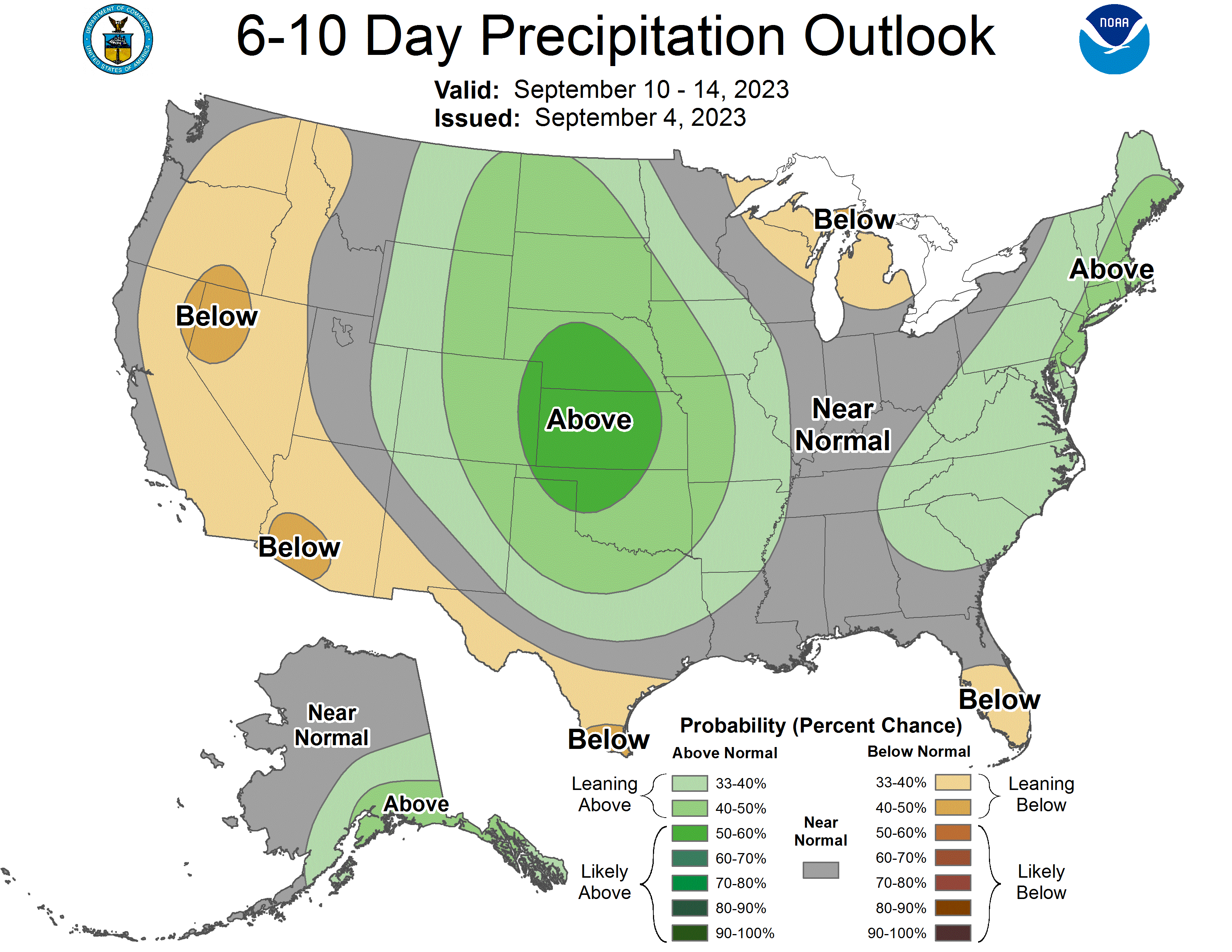
Could we see rain?
Re: September 2023
Posted: Mon Sep 04, 2023 11:25 pm
by Stratton20
Me when I see the newly update 6–10 and 8-14 day precipitation outlooks from Noaa
Re: September 2023
Posted: Tue Sep 05, 2023 8:01 am
by MontgomeryCoWx
Give me 36 degrees and a foot of rain over this.

Re: September 2023
Posted: Tue Sep 05, 2023 9:01 am
by tireman4
000
FXUS64 KHGX 051134
AFDHGX
Area Forecast Discussion
National Weather Service Houston/Galveston TX
634 AM CDT Tue Sep 5 2023
...New AVIATION...
.SHORT TERM...
(Today through Wednesday Night)
Issued at 344 AM CDT Tue Sep 5 2023
Deep, low-level onshore flow will keep the mid/lower atmosphere very
moist today. PWs are expected to range from 1.60-1.70" in our
northern counties to near 2.0" at the coast. Meanwhile, a weak
shortwave over south-central Texas will slowly crawl eastward,
introducing modest lift over our region today. Current CAMs guidance
suggest only isolated to maybe scattered shower/thunderstorm
activity. This doesn`t seem unreasonable given the weak mid-level
capping in the forecast soundings. However, CAMs generally
underestimated rainfall coverage yesterday and the atmospheric set-
up of today is similar. Therefore, today`s PoPs are a compromise
between the generally drier CAMs and the wetter NBM guidance,
ranging from as low as ~20% over our CWA`s western fringes to ~50%
from the I-45 corridor points east.
By Wednesday, the upper-air pattern will be transitioning to a more
ridge dominant regime, acting to suppress PoPs and increase
temperatures. However, residual PVA will keep PoPs at least slight.
There exists model discrepancies regarding the PW amounts. In
addition, onshore flow will gradually become less deep throughout
the day with NE flow prevailing above 925MB by the afternoon. Given
the potential for PWs to remain high along with the NBM guidance`s
insistence on higher rain chances, we opted to not go too low with
PoPs. However, PoPs are generally lower for tomorrow, ranging from
10-20% in our northern counties to 20-35% across the southern CWA.
Regarding temperatures, afternoon inland highs are expected to be in
the 95F to 100F range today and 96F to 102F range tomorrow with low
90s near the coast. Due to the more deep onshore flow today, dew
points are likely to remain quite high into the afternoon. The
current blend used for our forecast dew points lead to widespread
apparent temperatures of 106F to 108F with locally higher values,
especially over our coastal and eastern counties. Therefore,
conditions will be very close to Heat Advisory criteria this
afternoon and may warrant the issuance of an advisory later today.
Dew points appear a little lower tomorrow but with temperatures a
degree or two hotter. Therefore, we could be flirting with advisory
criteria once again on Wednesday.
Self
&&
.LONG TERM...
(Thursday through Monday)
Issued at 344 AM CDT Tue Sep 5 2023
Mid/upper level ridging building back into the area from the west will
allow inland high temperatures to rise back into the low 100s, and these
values in combination with persistent onshore winds and elevated dew
points will support the need for a Heat Advisory for much of the area.
Some spots could get very close or exceed a high of 105 degrees (especially
on Friday), and this would support an Excessive Heat Warning. A few
isolated showers/storms could develop (embedded weak shortwaves/disturbances),
but expecting the ridge to win out and keep a majority of the area dry.
All heat safety precautions should be taken areawide.
The pattern begins to change over the weekend as the ridge retreats
to the west. Decreasing heights will allow for a drop in high temperatures,
but we look to still be flirting with 100 degrees for both Saturday
(heat index values could support another Heat Advisory) and Sunday
(heat index values below advisory levels). Rain chances are back in
the forecast starting on Saturday and continuing into Sunday and possibly
Monday as heights lower and shortwaves on the eastern fringes of the
ridge edge toward/into the area from the north. Will keep rain chances
on the low side for now as timing these shortwaves is difficult this
far out. If the rains/storms timing is right, we could end up with ever
so slightly cooler afternoon highs.
42
&&
.AVIATION...
(12Z TAF Issuance)
Issued at 627 AM CDT Tue Sep 5 2023
Southerly winds this morning will become more southeasterly this
afternoon. Afternoon sustained winds are expected to peak 10-12
kts with higher gusts. Showers streaming in from the Gulf will
continue this morning and push northward. There is still a
possibility of TS activity. However, any TS activity will be
isolated and doesn`t warrant VCTS as of this update. Therefore,
VCTS was replaced with VCSH for the afternoon time frame. Winds
decrease overnight with mixed guidance support for MVFR cigs for
our northern terminals. Seeing that our northern terminals managed
periodic MVFR this morning, we lean towards cigs dropping to MVFR
levels late tonight into early tomorrow morning at CLL, UTS, and
potentially CXO.
&&
.MARINE...
Issued at 344 AM CDT Tue Sep 5 2023
Light to moderate onshore winds will prevail through mid week, with
wind speeds at times approaching caution thresholds. Winds will diminish
slightly by the end of the week and then persist into the weekend. There
will be a daily chance of isolated thunderstorms, which may at times
produce stronger wind gusts and elevated seas.
42
&&
.FIRE WEATHER...
Issued at 344 AM CDT Tue Sep 5 2023
Afternoon RH values will gradually decline through Friday, resulting
in a corresponding increase in the fire risk as we approach week`s
end. By Thursday and especially Friday, Brazos Valley and Piney
Woods afternoon RH could drop below 30 percent. There is a chance
of isolated to scattered showers and thunderstorms today and
tomorrow. However, many locations will not receive any rain. In
addition, those lucky enough to receive a beneficial downpour are
unlikely to see a fundamental change in the state of the dry fuels
that have been in place this summer. So generally speaking, there
remains an enhanced fire risk through the forecast period, with the
highest risk occurring on Thursday and Friday. Burn bans remain in
effect for all of SE TX.
Self
&&
.CLIMATE...
Issued at 344 AM CDT Tue Sep 5 2023
Yesterday`s high temperature at Houston IAH was only 96 degrees.
The last time IAH recorded a high temperature of only 96 degrees
was on July 9th. This streak of 57 consecutive days of 96 degrees
or higher beats the old record of 36 straight days in July-August
1993.
42
&&
.PRELIMINARY POINT TEMPS/POPS...
College Station (CLL) 101 77 101 77 / 30 10 10 10
Houston (IAH) 97 79 99 78 / 50 10 30 0
Galveston (GLS) 91 83 91 81 / 50 10 30 10
&&
.HGX WATCHES/WARNINGS/ADVISORIES...
TX...High Rip Current Risk through this evening for TXZ436>439.
GM...None.
&&
$$
SHORT TERM...Adams
LONG TERM....Adams
AVIATION...Self
MARINE...Adams
Re: September 2023
Posted: Tue Sep 05, 2023 9:05 am
by user:null
Hmmm...
tireman4 wrote: ↑Tue Sep 05, 2023 9:01 am
000
FXUS64 KHGX 051134
AFDHGX
Area Forecast Discussion
National Weather Service Houston/Galveston TX
.SHORT TERM...
(Today through Wednesday Night)
Issued at 344 AM CDT Tue Sep 5 2023
Deep, low-level onshore flow will keep the mid/lower atmosphere very
moist today. PWs are expected to range from 1.60-1.70" in our
northern counties to near 2.0" at the coast. Meanwhile, a weak
shortwave over south-central Texas will slowly crawl eastward,
introducing modest lift over our region today. Current CAMs guidance
suggest only isolated to maybe scattered shower/thunderstorm
activity. This doesn`t seem unreasonable given the weak mid-level
capping in the forecast soundings. However, CAMs generally
underestimated rainfall coverage yesterday and the atmospheric set-
up of today is similar. Therefore, today`s PoPs are a compromise
between the generally drier CAMs and the wetter NBM guidance,
ranging from as low as ~20% over our CWA`s western fringes to ~50%
from the I-45 corridor points east.
Re: September 2023
Posted: Tue Sep 05, 2023 9:12 am
by MontgomeryCoWx
Cosgrove talking about how we’ve entered our transition period for Fall this morning. He says the transition should take place through late month, and October should look and feel like a Nino fall.
Re: September 2023
Posted: Tue Sep 05, 2023 9:25 am
by Cpv17
MontgomeryCoWx wrote: ↑Tue Sep 05, 2023 8:01 am
Give me 36 degrees and a foot of rain over this.
Man bro, if it’s gonna be 36, it may as well be a few degrees colder for some white stuff. We might actually have a chance for that this winter. 2009 is a decent analog.
Re: September 2023
Posted: Tue Sep 05, 2023 9:41 am
by MontgomeryCoWx
Cpv17 wrote: ↑Tue Sep 05, 2023 9:25 am
MontgomeryCoWx wrote: ↑Tue Sep 05, 2023 8:01 am
Give me 36 degrees and a foot of rain over this.
Man bro, if it’s gonna be 36, it may as well be a few degrees colder for some white stuff. We might actually have a chance for that this winter. 2009 is a decent analog.
That was my point. I’d take a frustrating 36 and a foot of rain over 100 and dry on end.
Re: September 2023
Posted: Tue Sep 05, 2023 11:17 am
by Stratton20
Pow Ponder says we can all say adios to the heat ridge for good next week, ridge backs away into mexico and then begins to rebuild over the western US, Polar jet and the sub tropical jet begin to split with the sub tropical jet lowering further south, should start to see moisture from the pacific begin to override the sub tropical jet and spread into texas, the end is here folks, the heat ridge is gone for good early next week
Re: September 2023
Posted: Tue Sep 05, 2023 11:21 am
by Cromagnum
Oh hey, the same area that got rain yesterday gets it again today. The rest of us get to pound (literally) sand. Like a broken record.
Re: September 2023
Posted: Tue Sep 05, 2023 11:26 am
by Pas_Bon
Stratton20 wrote: ↑Tue Sep 05, 2023 11:17 am
Pow Ponder says we can all say adios to the heat ridge for good next week, ridge backs away into mexico and then begins to rebuild over the western US, Polar jet and the sub tropical jet begin to split with the sub tropical jet lowering further south, should start to see moisture from the pacific begin to override the sub tropical jet and spread into texas, the end is here folks, the heat ridge is gone for good early next week
I'm not saying this time is incorrect (different synoptic setup), but the amount of times I have seen the ridge end talk NOT materialize this Summer has been ridiculous.
I have a feeling this truly is the end of that SOB, but I still am leery.
Re: September 2023
Posted: Tue Sep 05, 2023 11:29 am
by DoctorMu
Nothing. Not today. Not soon. I'll believe the changes when they happen. The Ensembles have not bought into an actual FROPA and rain yet.
https://www.youtube.com/watch?v=qynydbBpqy4


