
Looks like we have a 60mph Tropical Storm Ernesto.
AL, 05, 2012080406, , BEST, 0, 139N, 664W, 50, 1001, TS
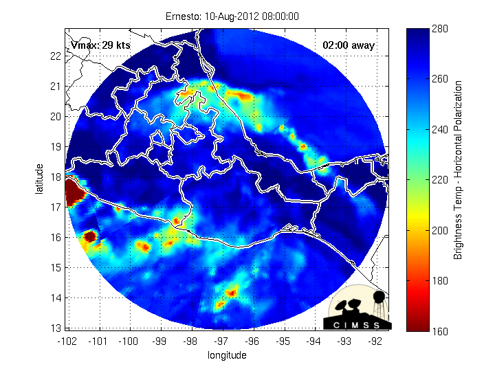
Ernesto Dissipates Over Mexico
-
Belmer

- Global Moderator

- Posts: 745
- Joined: Thu Jan 06, 2011 7:29 pm
- Location: Dallas, TX
- Contact:
Blake
Boomer Sooner
Boomer Sooner
-
TexasBreeze
- Posts: 1017
- Joined: Sun Sep 26, 2010 4:46 pm
- Location: NW Houston, TX
- Contact:
I know that feeling it's hard for me to shut my phone internet off and go to bed too. I find myself getting up earlier too!:)Belmer wrote:I knew this was going to happen. I get in bed but can't sleep. Haha, this storm is a week out and is already ruining my sleep schedule.
Hey Andrew,
Just for fun, can you post the FIM Experimental solution and what it has it doing!?
-
Andrew
- Site Admin

- Posts: 3506
- Joined: Wed Feb 03, 2010 9:46 pm
- Location: North-West Houston
- Contact:
Euro is farther north compared to the 12z run. Shows a stronger system. Before we get into an argument on which model is right lets see how this system looks tomorrow night. If it looks as good as it does now (or better) I might start looking at the GFDL more.
For Your Infinite Source For All Things Weather Visit Our Facebook
-
Andrew
- Site Admin
- Posts: 3506
- Joined: Wed Feb 03, 2010 9:46 pm
- Location: North-West Houston
- Contact:
TexasBreeze wrote:I know that feeling it's hard for me to shut my phone internet off and go to bed too. I find myself getting up earlier too!:)Belmer wrote:I knew this was going to happen. I get in bed but can't sleep. Haha, this storm is a week out and is already ruining my sleep schedule.
Hey Andrew,
Just for fun, can you post the FIM Experimental solution and what it has it doing!?
FIM goes south also (looks similar to Euro and GFS)
http://fim.noaa.gov/FIMscp/Welcome.cgi? ... 2012+-+00Z
For Your Infinite Source For All Things Weather Visit Our Facebook
-
Andrew
- Site Admin
- Posts: 3506
- Joined: Wed Feb 03, 2010 9:46 pm
- Location: North-West Houston
- Contact:
One last thing to note after looking at the latest shear, shear tendency, and steering winds is that shear does not look nearly as bad ahead of it as it did yesterday. The key here is that the stronger this system gets, the more the steering currents show a WNW-NW movement. That paired with the slowing movement gives Ernesto a good chance of further intensification. Here is the current steering currents through 400mb
700-850mb
500-850mb
400-850mb
700-850mb
500-850mb
400-850mb
For Your Infinite Source For All Things Weather Visit Our Facebook
-
srainhoutx

- Site Admin
- Posts: 19699
- Joined: Tue Feb 02, 2010 2:32 pm
- Location: Maggie Valley, NC
- Contact:
HPC Morning Update:
A MAJOR WRINKLE IN THE FORECAST THIS PERIOD IS THE SYSTEM EXPECTED
TO BECOME HURRICANE ERNESTO. THE 00Z GLOBAL DETERMINISTIC
GUIDANCE MOVES THE SYSTEM INTO CENTRAL AMERICA/BELIZE THROUGH THE
BAY OF CAMPECHE TOWARDS EAST-CENTRAL MEXICO BY NEXT WEEKEND /WELL
SOUTH OF THE NHC FORECAST/ WHILE THE 12Z GLOBAL ENSEMBLE GUIDANCE
BRINGS A SIGNIFICANT NUMBER OF MEMBERS MORE
NORTHWARD...THREATENING AREAS AS FAR NORTH AS THE NORTHWEST AND
NORTH-CENTRAL GULF COAST. ENERGY MOVING DOWN FROM THE WESTERLIES
THROUGH THE BREAK IN THE SUBTROPICAL RIDGE AND FRACTURING AS IT
RETROGRADES UNDER THE BASE OF THE WARM CORE RIDGE /THE USUAL WAY
UPPER LOWS IN THE SUBTROPICS AND TROPICS DEVELOP/ COULD EASILY
LURE ERNESTO FARTHER NORTHWARD...SO KEPT WITH CONTINUITY FROM THE
17Z COORDINATION CALL BETWEEN NHC/HPC AND MOVED ERNESTO TOWARDS
NORTHEAST MEXICO TO STAY WELL WITHIN THE RANGE OF POSSIBILITIES.
WITH ENSEMBLE GUIDANCE SPREAD BETWEEN THE FLORIDA PANHANDLE AND
VERA CRUZ STATE AS POSSIBLE LANDFALL POINTS ALONG THE GULF COAST
BY THIS TIME NEXT WEEK...ALL OF WHICH ARE POSSIBLE IF AN UPPER LOW
DROPS OUT OF THE WESTERLIES INTO/THROUGH THE NORTHWEST GULF OF
MEXICO AND INTERACTS WITH ERNESTO LATE NEXT WEEK INTO THE
WEEKEND...THE STORM CLEARLY HAS OPTIONS REGARDING ITS ULTIMATE
PATH THROUGH THE GULF OF MEXICO. STAY TUNED.
Carla/Alicia/Jerry(In The Eye)/Michelle/Charley/Ivan/Dennis/Katrina/Rita/Wilma/Humberto/Ike/Harvey
Member: National Weather Association
Facebook.com/Weather Infinity
Twitter @WeatherInfinity
Member: National Weather Association
Facebook.com/Weather Infinity
Twitter @WeatherInfinity
-
srainhoutx
- Site Admin
- Posts: 19699
- Joined: Tue Feb 02, 2010 2:32 pm
- Location: Maggie Valley, NC
- Contact:
TROPICAL STORM ERNESTO DISCUSSION NUMBER 11...CORRECTED
NWS NATIONAL HURRICANE CENTER MIAMI FL AL052012
500 AM AST SAT AUG 04 2012
CORRECTED TIME OF AMSU PASS IN FIRST PARAGRAPH
THE SATELLITE PRESENTATION OF ERNESTO HAS BEEN GRADUALLY IMPROVING
OVERNIGHT. THE COVERAGE OF COLD TOPS HAS INCREASED WHILE CONVECTIVE
BANDING FEATURES HAVE BECOME MORE APPARENT AND THE OUTFLOW HAS
EXPANDED IN THE NORTHERN SEMICIRCLE. IN ADDITION...AN AMSU PASS
FROM 0549 UTC SHOWED A LITTLE BETTER STRUCTURE IN THE INNER CORE.
THE INITIAL INTENSITY IS RAISED TO 50 KT BASED ON A BLEND OF THE
LATEST DVORAK ESTIMATES FROM TAFB AND SAB.
THE LOW-SHEAR ENVIRONMENT AND IMPROVED STRUCTURE OF THE CYCLONE
SUGGEST AT LEAST STEADY INTENSIFICATION OVER THE NEXT COUPLE OF
DAYS. HOWEVER...THE DISAGREEMENT IN THE INTENSITY GUIDANCE
CONTINUES. THE SHIPS AND LGEM STILL SHOW A FASTER PACE OF
INTENSIFICATION...WHILE THE DYNAMICAL MODELS SHOW STRENGTHENING AT A
MUCH SLOWER RATE. GIVEN THE CURRENT TRENDS...THE OFFICIAL FORECAST
HAS BEEN ADJUSTED UPWARD AND SHOWS ERNESTO BECOMING A HURRICANE IN
36 HOURS...BUT REMAINS BELOW THE STATISTICAL-DYNAMICAL GUIDANCE.
LATER IN THE PERIOD...THE GFDL SHOWS MORE INTENSIFICATION THAN
EARLIER RUNS...BUT THE HWRF AND MUCH OF THE HFIP GUIDANCE REMAIN
WEAKER. AT DAYS 3 THROUGH 5 THE NEW NHC FORECAST HAS BEEN ADJUSTED
UPWARD SLIGHTLY...AND IS CLOSE TO THE IV15 CONSENSUS AND THE
FLORIDA STATE SUPERENSEMBLE. NEEDLESS TO SAY...THERE IS LOW
CONFIDENCE IN THE INTENSITY FORECAST THROUGH THE PERIOD.
THE INITIAL MOTION ESTIMATE IS 275/16 AS ERNESTO IS SITUATED SOUTH
OF THE SUBTROPICAL RIDGE. THE TRACK MODEL GUIDANCE IS IN GOOD
AGREEMENT THROUGH 48 HOURS IN SHOWING A CONTINUED WESTWARD MOTION
AS THE RIDGE BUILDS WESTWARD TO NORTH OF THE CYCLONE. THROUGH THIS
TIME THE NHC FORECAST IS SIMPLY AN UPDATE OF THE PREVIOUS ONE. AT
DAYS 3 THROUGH 5 THERE CONTINUES TO BE LARGE SPREAD IN THE MODEL
GUIDANCE. THE BIGGEST CHANGE THIS CYCLE IS A SOUTHWARD SHIFT IN THE
UKMET...WHICH NOW JOINS THE GFS AND ECMWF IN SHOWING THAT ERNESTO
WILL REMAIN TOO FAR SOUTH TO MOVE INTO A WEAKNESS IN THE
SUBTROPICAL RIDGE THAT DEVELOPS OVER THE EASTERN GULF OF MEXICO IN
4 TO 5 DAYS. HOWEVER...THE GFDL...HWRF...AND SEVERAL OF THE HFIP
MODELS CONTINUE TO SHOW ERNESTO GAINING MORE LATITUDE IN THE SECOND
HALF OF THE FORECAST PERIOD. THE NHC FORECAST HAS BEEN ADJUSTED A
LITTLE TO THE SOUTH TOWARD THE NEW MULTI-MODEL CONSENSUS AT DAYS 3
THROUGH 5...BUT STILL LIES TO THE RIGHT OF THE CENTER OF THE
GUIDANCE ENVELOPE.
INTERESTS IN JAMAICA SHOULD MONITOR THE PROGRESS OF ERNESTO...AS A
TROPICAL STORM WATCH OR WARNING COULD BE REQUIRED FOR PORTIONS OF
THAT ISLAND LATER TODAY.
FORECAST POSITIONS AND MAX WINDS
INIT 04/0900Z 14.1N 67.2W 50 KT 60 MPH
12H 04/1800Z 14.5N 69.7W 55 KT 65 MPH
24H 05/0600Z 15.1N 73.1W 60 KT 70 MPH
36H 05/1800Z 15.7N 76.4W 65 KT 75 MPH
48H 06/0600Z 16.3N 79.1W 70 KT 80 MPH
72H 07/0600Z 17.5N 83.0W 75 KT 85 MPH
96H 08/0600Z 19.5N 86.5W 80 KT 90 MPH
120H 09/0600Z 21.5N 90.0W 70 KT 80 MPH
$$
FORECASTER BRENNAN
- Attachments
-
Carla/Alicia/Jerry(In The Eye)/Michelle/Charley/Ivan/Dennis/Katrina/Rita/Wilma/Humberto/Ike/Harvey
Member: National Weather Association
Facebook.com/Weather Infinity
Twitter @WeatherInfinity
Member: National Weather Association
Facebook.com/Weather Infinity
Twitter @WeatherInfinity
-
srainhoutx
- Site Admin
- Posts: 19699
- Joined: Tue Feb 02, 2010 2:32 pm
- Location: Maggie Valley, NC
- Contact:
06Z Track & Intensity:
- Attachments
-
-
Carla/Alicia/Jerry(In The Eye)/Michelle/Charley/Ivan/Dennis/Katrina/Rita/Wilma/Humberto/Ike/Harvey
Member: National Weather Association
Facebook.com/Weather Infinity
Twitter @WeatherInfinity
Member: National Weather Association
Facebook.com/Weather Infinity
Twitter @WeatherInfinity
-
srainhoutx
- Site Admin
- Posts: 19699
- Joined: Tue Feb 02, 2010 2:32 pm
- Location: Maggie Valley, NC
- Contact:
As the HPC mentions, some respect had to be given to the ensembles ~vs~ the operational guidance and that is why there still remains a lot of uncertainty exactly where Ernesto will travel beyond the Yucatan...
- Attachments
-
-
Carla/Alicia/Jerry(In The Eye)/Michelle/Charley/Ivan/Dennis/Katrina/Rita/Wilma/Humberto/Ike/Harvey
Member: National Weather Association
Facebook.com/Weather Infinity
Twitter @WeatherInfinity
Member: National Weather Association
Facebook.com/Weather Infinity
Twitter @WeatherInfinity
-
srainhoutx
- Site Admin
- Posts: 19699
- Joined: Tue Feb 02, 2010 2:32 pm
- Location: Maggie Valley, NC
- Contact:
TROPICAL STORM ERNESTO TROPICAL CYCLONE UPDATE
NWS NATIONAL HURRICANE CENTER MIAMI FL AL052012
800 AM ADT SAT AUG 04 2012
AT 8 AM ADT...1200 UTC...THE GOVERNMENT OF JAMAICA HAS ISSUED A
TROPICAL STORM WATCH FOR JAMAICA.
$$
FORECASTER AVILA
NWS NATIONAL HURRICANE CENTER MIAMI FL AL052012
800 AM ADT SAT AUG 04 2012
AT 8 AM ADT...1200 UTC...THE GOVERNMENT OF JAMAICA HAS ISSUED A
TROPICAL STORM WATCH FOR JAMAICA.
$$
FORECASTER AVILA
Carla/Alicia/Jerry(In The Eye)/Michelle/Charley/Ivan/Dennis/Katrina/Rita/Wilma/Humberto/Ike/Harvey
Member: National Weather Association
Facebook.com/Weather Infinity
Twitter @WeatherInfinity
Member: National Weather Association
Facebook.com/Weather Infinity
Twitter @WeatherInfinity
-
srainhoutx
- Site Admin
- Posts: 19699
- Joined: Tue Feb 02, 2010 2:32 pm
- Location: Maggie Valley, NC
- Contact:
Product: Air Force Vortex Message (URNT12 KNHC)
Transmitted: 4th day of the month at 11:47Z
Aircraft: Air Force Aircraft (Last 3 digits of the tail number are 309)
Storm Number & Year: 05L in 2012
Storm Name: Ernesto (flight in the North Atlantic basin)
Mission Number: 4
Observation Number: 03
A. Time of Center Fix: 4th day of the month at 11:34:40Z
B. Center Fix Coordinates: 14°22'N 67°53'W (14.3667N 67.8833W)
B. Center Fix Location: 305 miles (491 km) to the SSW (203°) from San Juan, Puerto Rico (USA).
C. Minimum Height at Standard Level: 1,475m (4,839ft) at 850mb
D. Estimated (by SFMR or visually) Maximum Surface Wind: 36kts (~ 41.4mph)
E. Location of the Estimated Maximum Surface Wind: 43 nautical miles (49 statute miles) to the N (5°) of center fix
F. Maximum Flight Level Wind Inbound: From 107° at 41kts (From the ESE at ~ 47.2mph)
G. Location of Maximum Flight Level Wind Inbound: 65 nautical miles (75 statute miles) to the N/NNE (11°) of center fix
H. Minimum Sea Level Pressure: 1006mb (29.71 inHg)
I. Maximum Flight Level Temp & Pressure Altitude Outside Eye: 18°C (64°F) at a pressure alt. of 1,524m (5,000ft)
J. Maximum Flight Level Temp & Pressure Altitude Inside Eye: 22°C (72°F) at a pressure alt. of 1,525m (5,003ft)
K. Dewpoint Temp (collected at same location as temp inside eye): 10°C (50°F)
K. Sea Surface Temp (collected at same location as temp inside eye): Not Available
L. Eye Character: Not Available
M. Eye Shape: Not Available
N. Fix Determined By: Penetration, Wind and Pressure
N. Fix Levels (sfc and flt lvl centers are within 5nm of each other): Surface and 850mb
O. Navigation Fix Accuracy: 0.02 nautical miles
O. Meteorological Accuracy: 3 nautical miles
Remarks Section:
Maximum Flight Level Wind: 41kts (~ 47.2mph) in the north quadrant at 11:13:30Z
Maximum Flight Level Temp: 22°C (72°F) which was observed 13 nautical miles (15 statute miles) to the NW (322°) from the flight level center
Carla/Alicia/Jerry(In The Eye)/Michelle/Charley/Ivan/Dennis/Katrina/Rita/Wilma/Humberto/Ike/Harvey
Member: National Weather Association
Facebook.com/Weather Infinity
Twitter @WeatherInfinity
Member: National Weather Association
Facebook.com/Weather Infinity
Twitter @WeatherInfinity
-
srainhoutx
- Site Admin
- Posts: 19699
- Joined: Tue Feb 02, 2010 2:32 pm
- Location: Maggie Valley, NC
- Contact:
06Z HWRF & GFDL:
- Attachments
-
Carla/Alicia/Jerry(In The Eye)/Michelle/Charley/Ivan/Dennis/Katrina/Rita/Wilma/Humberto/Ike/Harvey
Member: National Weather Association
Facebook.com/Weather Infinity
Twitter @WeatherInfinity
Member: National Weather Association
Facebook.com/Weather Infinity
Twitter @WeatherInfinity
-
Hurriken
- Posts: 1
- Joined: Tue Jun 22, 2010 10:59 am
- Contact:
1006 mb is good news I think. It shows that the mass of dry air to the immediate west of Ernesto is keeping it down at the moment.
-
srainhoutx
- Site Admin
- Posts: 19699
- Joined: Tue Feb 02, 2010 2:32 pm
- Location: Maggie Valley, NC
- Contact:
Product: Air Force Vortex Message (URNT12 KNHC)
Transmitted: 4th day of the month at 13:02Z
Aircraft: Air Force Aircraft (Last 3 digits of the tail number are 309)
Storm Number & Year: 05L in 2012
Storm Name: Ernesto (flight in the North Atlantic basin)
Mission Number: 4
Observation Number: 07
A. Time of Center Fix: 4th day of the month at 12:29:20Z
B. Center Fix Coordinates: 14°19'N 68°05'W (14.3167N 68.0833W)
B. Center Fix Location: 312 miles (502 km) to the SSE (157°) from Santo Domingo, Dominican Republic.
C. Minimum Height at Standard Level: 1,477m (4,846ft) at 850mb
D. Estimated (by SFMR or visually) Maximum Surface Wind: 37kts (~ 42.6mph)
E. Location of the Estimated Maximum Surface Wind: 42 nautical miles (48 statute miles) to the SE (133°) of center fix
F. Maximum Flight Level Wind Inbound: From 200° at 29kts (From the SSW at ~ 33.4mph)
G. Location of Maximum Flight Level Wind Inbound: 51 nautical miles (59 statute miles) to the SE (135°) of center fix
H. Minimum Sea Level Pressure: 1007mb (29.74 inHg)
I. Maximum Flight Level Temp & Pressure Altitude Outside Eye: 17°C (63°F) at a pressure alt. of 1,528m (5,013ft)
J. Maximum Flight Level Temp & Pressure Altitude Inside Eye: 19°C (66°F) at a pressure alt. of 1,527m (5,010ft)
K. Dewpoint Temp (collected at same location as temp inside eye): 10°C (50°F)
K. Sea Surface Temp (collected at same location as temp inside eye): Not Available
L. Eye Character: Not Available
M. Eye Shape: Not Available
N. Fix Determined By: Penetration, Wind, Pressure and Temperature
N. Fix Levels (sfc and flt lvl centers are within 5nm of each other): Surface and 850mb
O. Navigation Fix Accuracy: 0.02 nautical miles
O. Meteorological Accuracy: 4 nautical miles
Remarks Section:
Maximum Flight Level Wind: 41kts (~ 47.2mph) in the north quadrant at 11:13:30Z
Maximum Flight Level Wind Outbound: 34kts (~ 39.1mph) in the northwest quadrant at 12:56:00Z
Carla/Alicia/Jerry(In The Eye)/Michelle/Charley/Ivan/Dennis/Katrina/Rita/Wilma/Humberto/Ike/Harvey
Member: National Weather Association
Facebook.com/Weather Infinity
Twitter @WeatherInfinity
Member: National Weather Association
Facebook.com/Weather Infinity
Twitter @WeatherInfinity
-
srainhoutx
- Site Admin
- Posts: 19699
- Joined: Tue Feb 02, 2010 2:32 pm
- Location: Maggie Valley, NC
- Contact:
HPC Update:
PRELIMINARY EXTENDED FORECAST DISCUSSION
NWS HYDROMETEOROLOGICAL PREDICTION CENTER CAMP SPRINGS MD
959 AM EDT SAT AUG 04 2012
VALID 12Z WED AUG 08 2012 - 12Z SAT AUG 11 2012
...ERNESTO MOVES THROUGH THE SOUTHERN GULF OF MEXICO THIS PERIOD...
A MAJOR WRINKLE IN THE FORECAST THIS PERIOD IS TROPICAL STORM
ERNESTO...EXPECTED TO BECOME HURRICANE ERNESTO. THE GLOBAL
ENSEMBLE GUIDANCE MOVES THE SYSTEM INTO CENTRAL AMERICA/BELIZE ON
DY 5...AND THROUGH THE BAY OF CAMPECHE TOWARDS EAST-CENTRAL MEXICO
DY 6/7. WHILE WE DO SEE THE TYPICAL NORTH TO SOUTH SPREAD IN THE
TRACK GUIDANCE BY DY 6/7...THE CLUSTERING AROUND THE MEAN AND
TRACKS WITHIN THE OPERATIONAL GFS/ECMWF HAVE BEEN REASONABLY
CONSISTENT FROM RUN TO RUN. WITH THE CYCLONE BEGINNING ITS LIFE IN
THE CENTRAL CARIBBEAN...IT IS LESS LIKELY TO BE INFLUENCED BY
NORTHERN STREAM TROUGHING IN THE EASTERN U.S. AT LEAST THROUGH DY
5/6. THIS GIVES US AT LEAST SOME CONFIDENCE IN EXTRAPOLATING A DY
6/7 POSITION OVER THE WESTERN GULF...TO THE SOUTH OF THE TEXAS
COAST. STILL...ANY POTENTIAL LANDFALL IN THE U.S. OR MEXICO WOULD
OCCUR NEAR THE END OF THE 7 DAY PERIOD...MEANING THERE IS STILL A
WIDE RANGE OF POSSIBILITIES...AND INTERESTS ALONG THE GULF COAST
WILL NEED TO CLOSELY MONITOR THE OFFICIAL FORECAST FROM THE
NATIONAL HURRICANE CENTER.
Carla/Alicia/Jerry(In The Eye)/Michelle/Charley/Ivan/Dennis/Katrina/Rita/Wilma/Humberto/Ike/Harvey
Member: National Weather Association
Facebook.com/Weather Infinity
Twitter @WeatherInfinity
Member: National Weather Association
Facebook.com/Weather Infinity
Twitter @WeatherInfinity
-
srainhoutx
- Site Admin
- Posts: 19699
- Joined: Tue Feb 02, 2010 2:32 pm
- Location: Maggie Valley, NC
- Contact:
06Z NCEP Ensembles:
Carla/Alicia/Jerry(In The Eye)/Michelle/Charley/Ivan/Dennis/Katrina/Rita/Wilma/Humberto/Ike/Harvey
Member: National Weather Association
Facebook.com/Weather Infinity
Twitter @WeatherInfinity
Member: National Weather Association
Facebook.com/Weather Infinity
Twitter @WeatherInfinity
-
Portastorm

- Posts: 800
- Joined: Wed Feb 03, 2010 3:04 pm
- Location: Southwest Austin/Oak Hill, TX
- Contact:
Strong consensus at the moment for Ernesto's east-central Mexican coast landfall. That would seem to match what some of our pro mets are thinking as well.
-
srainhoutx
- Site Admin
- Posts: 19699
- Joined: Tue Feb 02, 2010 2:32 pm
- Location: Maggie Valley, NC
- Contact:
Product: Air Force Vortex Message (URNT12 KNHC)
Transmitted: 4th day of the month at 14:27Z
Aircraft: Air Force Aircraft (Last 3 digits of the tail number are 309)
Storm Number & Year: 05L in 2012
Storm Name: Ernesto (flight in the North Atlantic basin)
Mission Number: 4
Observation Number: 11
A. Time of Center Fix: 4th day of the month at 13:56:00Z
B. Center Fix Coordinates: 14°18'N 68°27'W (14.3N 68.45W)
B. Center Fix Location: 304 miles (490 km) to the SSE (162°) from Santo Domingo, Dominican Republic.
C. Minimum Height at Standard Level: 1,483m (4,865ft) at 850mb
D. Estimated (by SFMR or visually) Maximum Surface Wind: 22kts (~ 25.3mph)
E. Location of the Estimated Maximum Surface Wind: 5 nautical miles (6 statute miles) to the SSW (193°) of center fix
F. Maximum Flight Level Wind Inbound: From 284° at 17kts (From the WNW at ~ 19.6mph)
G. Location of Maximum Flight Level Wind Inbound: 9 nautical miles (10 statute miles) to the SSW (209°) of center fix
H. Minimum Sea Level Pressure: 1008mb (29.77 inHg)
I. Maximum Flight Level Temp & Pressure Altitude Outside Eye: 18°C (64°F) at a pressure alt. of 1,524m (5,000ft)
J. Maximum Flight Level Temp & Pressure Altitude Inside Eye: 19°C (66°F) at a pressure alt. of 1,530m (5,020ft)
K. Dewpoint Temp (collected at same location as temp inside eye): 9°C (48°F)
K. Sea Surface Temp (collected at same location as temp inside eye): Not Available
L. Eye Character: Not Available
M. Eye Shape: Not Available
N. Fix Determined By: Penetration, Wind, Pressure and Temperature
N. Fix Levels (sfc and flt lvl centers are within 5nm of each other): Surface and 850mb
O. Navigation Fix Accuracy: 0.02 nautical miles
O. Meteorological Accuracy: 3 nautical miles
Remarks Section:
Maximum Wind Outbound: 53kts (~ 61.0mph) in the northeast quadrant at 14:14:30Z
Maximum Flight Level Wind: 53kts (~ 61.0mph) in the northeast quadrant at 14:14:30Z
Carla/Alicia/Jerry(In The Eye)/Michelle/Charley/Ivan/Dennis/Katrina/Rita/Wilma/Humberto/Ike/Harvey
Member: National Weather Association
Facebook.com/Weather Infinity
Twitter @WeatherInfinity
Member: National Weather Association
Facebook.com/Weather Infinity
Twitter @WeatherInfinity