
2023 Hurricane Season Discussion
-
Stratton20
- Posts: 5560
- Joined: Tue Feb 09, 2021 11:35 pm
- Location: College Station, Texas
- Contact:
That’s probably the only way we are going to get widespread rain at this point until el nino really kicks in starting late september
-
user:null
- Posts: 465
- Joined: Fri Jul 01, 2022 7:04 pm
- Location: The Land of Sugar
- Contact:
I know. What I meant is that if the cyclone is organized, it HAS to hit Texas for good relief ... otherwise, it will heat/dry even more and whip fires if it goes towards Louisiana/east.Stratton20 wrote: ↑Sun Aug 06, 2023 9:03 pm That’s probably the only way we are going to get widespread rain at this point until el nino really kicks in starting late september
Whereas if nothing forms, it's a more disorganized inverted trough/diffuse surge, which will make it easier to retain rain chances even if some CoC goes east.
-
DoctorMu

- Posts: 7534
- Joined: Sun Jun 28, 2015 11:58 am
- Location: College Station
- Contact:
Right - we want to order extra lemonade - a weak tropical system, with widespread rain, just a breeze, maybe gale force gusts.user:null wrote: ↑Mon Aug 07, 2023 11:27 amI know. What I meant is that if the cyclone is organized, it HAS to hit Texas for good relief ... otherwise, it will heat/dry even more and whip fires if it goes towards Louisiana/east.Stratton20 wrote: ↑Sun Aug 06, 2023 9:03 pm That’s probably the only way we are going to get widespread rain at this point until el nino really kicks in starting late september
Whereas if nothing forms, it's a more disorganized inverted trough/diffuse surge, which will make it easier to retain rain chances even if some CoC goes east.
-
Stratton20
- Posts: 5560
- Joined: Tue Feb 09, 2021 11:35 pm
- Location: College Station, Texas
- Contact:
Some 12z EPS members do suggest some mischief as the wave approaching the leeward islands tracks westward, notice the lack of ridging over texas hmmm, its centered over florida
- Attachments
-
-
Cpv17
- Posts: 6774
- Joined: Fri Aug 31, 2018 1:58 pm
- Location: El Campo/Wharton
- Contact:
This is why I’m not throwing in the flag yet and still feel like at least somewhat of a pattern change is coming for the second half of the month.Stratton20 wrote: ↑Mon Aug 07, 2023 3:21 pm Some 12z EPS members do suggest some mischief as the wave approaching the leeward islands tracks westward, notice the lack of ridging over texas hmmm, its centered over florida
-
Stratton20
- Posts: 5560
- Joined: Tue Feb 09, 2021 11:35 pm
- Location: College Station, Texas
- Contact:
Cpv17 im pretty much 100% confident their will be a weakness in the ridge down the road, ensembles show the ridge breaking down by the 17th or so leaving us wide open, will be interesting to see if the EPS guidance starts to increase again
-
Cpv17
- Posts: 6774
- Joined: Fri Aug 31, 2018 1:58 pm
- Location: El Campo/Wharton
- Contact:
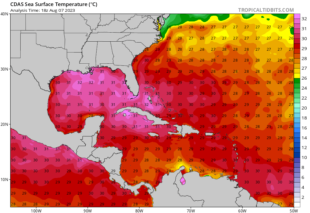
From what I can remember, this is the warmest I’ve ever seen the Gulf. And it continues to rise..craziness!
-
Stratton20
- Posts: 5560
- Joined: Tue Feb 09, 2021 11:35 pm
- Location: College Station, Texas
- Contact:
Cpv17 holy moly! Ive never seen it that warm either
-
Cpv17
- Posts: 6774
- Joined: Fri Aug 31, 2018 1:58 pm
- Location: El Campo/Wharton
- Contact:
It’s currently the warmest waters in the world.
-
Stratton20
- Posts: 5560
- Joined: Tue Feb 09, 2021 11:35 pm
- Location: College Station, Texas
- Contact:
Cpv17 wow! Its just a matter of time when a tropical wave makes it into the gulf, if all other conditions aline , someone could be in very serious trouble along the gulf coast down the road
-
jasons2k

- Posts: 6031
- Joined: Thu Feb 04, 2010 12:54 pm
- Location: Imperial Oaks
- Contact:
That whole thing is as warm or warmer than the infamous "loop current" that fueled Katrina and Rita. 
-
Cpv17
- Posts: 6774
- Joined: Fri Aug 31, 2018 1:58 pm
- Location: El Campo/Wharton
- Contact:
Yeah, no kidding. It’s freaking nuts how ridiculously warm the Gulf is. And what’s even crazier is that it continues to warm. That type of water could easily support a cat 5 in the right conditions. Scary to even think about. And something I’d never want to experience.
-
Dls2010r
- Posts: 183
- Joined: Sat Dec 01, 2018 6:21 am
- Contact:
It’s hot and I might be wrong but I’ve been told Galveston bay is shallow!!! Hard time supporting a cat 5. I’m not a weather guru but that’s what I’ve been told.
-
Stratton20
- Posts: 5560
- Joined: Tue Feb 09, 2021 11:35 pm
- Location: College Station, Texas
- Contact:
Even if the water is shallow their, their is plenty of deep warm water off the texas coast, and if a hurricane takes advantage of that, a little shallower water wont do much if its coming in as a cat 4-5
-
Dls2010r
- Posts: 183
- Joined: Sat Dec 01, 2018 6:21 am
- Contact:
I’m no meteorologist but I’ve been told it won’t support a cat 5. Beaumont different story.
-
Cpv17
- Posts: 6774
- Joined: Fri Aug 31, 2018 1:58 pm
- Location: El Campo/Wharton
- Contact:
I think you might be confused. Storms don’t form/strengthen over bays. They strengthen over large bodies of water like the Gulf of Mexico, Caribbean Sea, Atlantic Ocean…
If a storm comes barreling into an area as a cat 5, it’s not just going to significantly weaken just cuz it’s crossing over a small shallow area of water.
Water temps in the Gulf of Mexico are at record high levels. It would easily support a Cat 4/5 hurricane right now given the right conditions such as low wind shear and a moist environment with rising air.
-
Stratton20
- Posts: 5560
- Joined: Tue Feb 09, 2021 11:35 pm
- Location: College Station, Texas
- Contact:
Kind of like hurricane laura back in 2020, it took advantage of those warm deep gulf waters and nearly became a cat 5, the shallow coastal shelf waters as it approached the coast pretty much did nothing to weaken laura
-
jasons2k
- Posts: 6031
- Joined: Thu Feb 04, 2010 12:54 pm
- Location: Imperial Oaks
- Contact:
The west coat of Florida is extremely shallow and that did nothing to inhibit Charley or Matthew. With the right conditions, a Cat 5 would have no problem maintaining that intensity right up until landfall in Galveston.
Remember Harvey? It’s not much different in Port A. Ike was also strengthening at landfall.
Remember Harvey? It’s not much different in Port A. Ike was also strengthening at landfall.
-
MontgomeryCoWx

- Posts: 2635
- Joined: Wed Dec 14, 2011 4:31 pm
- Location: Weimar, TX
- Contact:
Took the words out of my mouth.jasons2k wrote: ↑Tue Aug 08, 2023 9:32 pm The west coat of Florida is extremely shallow and that did nothing to inhibit Charley or Matthew. With the right conditions, a Cat 5 would have no problem maintaining that intensity right up until landfall in Galveston.
Remember Harvey? It’s not much different in Port A. Ike was also strengthening at landfall.
Team #NeverSummer
-
DoctorMu
- Posts: 7534
- Joined: Sun Jun 28, 2015 11:58 am
- Location: College Station
- Contact:
Right. A hurricane builds its strength over vast, warm bodies of water. Their momentum carries them through the coast, sometimes staying together for awhile inland if they are large or powerful enough.Cpv17 wrote: ↑Tue Aug 08, 2023 6:47 pmI think you might be confused. Storms don’t form/strengthen over bays. They strengthen over large bodies of water like the Gulf of Mexico, Caribbean Sea, Atlantic Ocean…
If a storm comes barreling into an area as a cat 5, it’s not just going to significantly weaken just cuz it’s crossing over a small shallow area of water.
Water temps in the Gulf of Mexico are at record high levels. It would easily support a Cat 4/5 hurricane right now given the right conditions such as low wind shear and a moist environment with rising air.