
There's a cell north of the advisory's concern that's almost as potent. It's about to pop Lake Somerville, headed north towards Hearne.unome wrote:flood advisory
national weather service houston/galveston tx
853 pm cdt sun apr 17 2016
the national weather service in league city has issued a
* flood advisory for...
west central wharton county in southeastern texas...
south central colorado county in southeastern texas...
* until midnight cdt
* at 852 pm cdt...doppler radar indicated heavy rain due to thunderstorms. this will cause minor flooding in the advisory area. up to three to four inches of rain have already fallen.
* some locations that will experience flooding include... garwood and rock island.
precautionary/preparedness actions...
be especially cautious at night when it is harder to recognize the dangers of flooding.
excessive runoff from heavy rainfall will cause flooding of small creeks and streams... country roads... farmland... and other low lying spots.
a flood advisory means river or stream flows are elevated... or ponding of water in urban or other areas is occurring or is imminent.
April 2016 Recap: Regional Flood/Severe Weather
-
Ounce
- Posts: 470
- Joined: Sat Apr 17, 2010 10:18 pm
- Location: Houston
- Contact:
-
Ounce
- Posts: 470
- Joined: Sat Apr 17, 2010 10:18 pm
- Location: Houston
- Contact:
Also looks like the showers in the Gulf are petering out, for the moment at least.
-
unome
- Posts: 3062
- Joined: Fri Feb 12, 2010 6:11 pm
flood advisory
national weather service houston/galveston tx
928 pm cdt sun apr 17 2016
the national weather service in league city has issued a
* flood advisory for...
southeastern waller county in southeastern texas...
western harris county in southeastern texas...
east central austin county in southeastern texas...
central fort bend county in southeastern texas...
* until 1130 pm cdt
* at 927 pm cdt...doppler radar indicated heavy rain due to thunderstorms. this will cause minor flooding in the advisory area. two to three inches of rain have already fallen. the cluster of storms should slowly lift northward.
* some locations that will experience flooding include... sugar land... missouri city... rosenberg... stafford... katy... richmond... brookshire... mission bend... town west... pecan grove... first colony... eldridge / west oaks... addicks park ten... fresno... spring branch west... hockley... meadows place... waller... fulshear and pleak.
precautionary/preparedness actions...
turn around... don't drown when encountering flooded roads. most flood deaths occur in vehicles.
be especially cautious at night when it is harder to recognize the dangers of flooding.
excessive runoff from heavy rainfall will cause flooding of small creeks and streams... urban areas... highways... streets and underpasses as well as other drainage areas and low lying spots.
a flood advisory means river or stream flows are elevated... or ponding of water in urban or other areas is occurring or is imminent.
-
djjordan

- Posts: 929
- Joined: Fri Feb 05, 2010 7:19 pm
- Location: Montgomery, Texas
- Contact:
Some areas have already seen 2-3" of rain with these storms .... Some rainfall rates being reported at 4"/Hr. as well near Cinco Ranch. Nothing to mess around with definitely.
~~~When Thunder Roars Go Indoors~~~
~~~Turn Around Don't Drown~~~
~~~Run From The Water, Hide From The Wind~~~
~~~Turn Around Don't Drown~~~
~~~Run From The Water, Hide From The Wind~~~
-
unome
- Posts: 3062
- Joined: Fri Feb 12, 2010 6:11 pm
bulletin - eas activation requested
flash flood warning
national weather service houston/galveston tx
938 pm cdt sun apr 17 2016
the national weather service in league city has issued a
* flash flood warning for...
southeastern waller county in southeastern texas...
west central harris county in southeastern texas...
north central fort bend county in southeastern texas...
* until 1130 pm cdt
* at 937 pm cdt...doppler radar and automated rain gauges indicated thunderstorms producing heavy rain across the warned area. up to two inches of rain have already fallen. flash flooding is expected to begin shortly. these storms should continue to move northward at 10 to 15 mph. intense rain rates of 2 to 3 inches per hour will accompany the storms.
* some locations that will experience flooding include... katy... northern eldridge / west oaks... southwestern addicks park ten and cinco ranch.
precautionary/preparedness actions...
excessive runoff from heavy rainfall will cause flooding of small creeks and streams... urban areas... highways... streets and underpasses as well as other drainage areas and low lying spots.
Last edited by unome on Fri Apr 22, 2016 7:06 am, edited 1 time in total.
-
srainhoutx

- Site Admin

- Posts: 19700
- Joined: Tue Feb 02, 2010 2:32 pm
- Location: Maggie Valley, NC
- Contact:
Update from Jeff:
Flash Flood Warning for western Harris County until 1130pm.
Excessive rainfall of 1.0-1.5 inches in 30 minutes or less moving across far western Harris County. HCFCD FWS gages showing 1-hr storm totals of over 2.0 inches over western Harris County on South Mayde Creek. Flooding of roadways is likely under this batch of heavy rainfall.
Upstream development over Fort Bend County has subsided, but not sure we are done just yet. Low level speed convergence continues over Matagorda and Brazoria Counties helping to develop additional scattered activity along with maybe some help from back low level ESE winds inland over SE TX. Very subtle factors are helping to produce this rainfall event and since they are not well defined there is little confidence on how this plays out this evening. Think the main focus may shift out west to Columbus to College Station overnight where the low level jet focuses, but this remains to be seen.
Rainfall this evening of 1-2 inches over western Harris County was not included in all the forecasted QPF…so go ahead and add on 1-2 inches to all the advertised totals. Probably looking at storm totals of 4-6 inches additional on top of what has already fallen tonight into Tuesday night with isolated higher totals.
Activation time will be moved to 600am Monday instead of 900am. Still the potential that we will need to staff later tonight based on radar trends.
Carla/Alicia/Jerry(In The Eye)/Michelle/Charley/Ivan/Dennis/Katrina/Rita/Wilma/Humberto/Ike/Harvey
Member: National Weather Association
Facebook.com/Weather Infinity
Twitter @WeatherInfinity
Member: National Weather Association
Facebook.com/Weather Infinity
Twitter @WeatherInfinity
-
unome
- Posts: 3062
- Joined: Fri Feb 12, 2010 6:11 pm
3 major accidents within 20 minutes on NW section of Harris County
http://traffic.houstontranstar.org/laye ... e&dms=true
and more in other areas
Street Incidents
Location Description Time Reported Map
6800 COOK RD @ 12300 BELLAIRE BLVD Major Accident Today at 10:05 PM
835 GREENS RD #104 Major Accident Today at 10:02 PM
1600 SAINT EMANUEL ST @ 2100 LEELAND Major Accident Today at 10:00 PM
9200 S DAIRY ASHFORD @ 12700 BISSONNET ST Major Accident Today at 9:57 PM
3401 BLALOCK RD Major Accident Today at 9:55 PM
3910 BINGLE RD @ 12100 HEMPSTEAD RD Major Accident Today at 9:46 PM
8904 N HOUSTON ROSSLYN RD @ 6900 WOODFERN DR Major Accident Today at 9:35 PM
12700 BEECHNUT ST @ 8200 S DAIRY ASHFORD Major Accident Today at 9:11 PM
-
davidiowx
- Posts: 1183
- Joined: Thu Jan 23, 2014 2:39 pm
- Location: Richmond, TX
- Contact:
More storms building in northern Brazoria and southern Ft Bend counties
-
djjordan
- Posts: 929
- Joined: Fri Feb 05, 2010 7:19 pm
- Location: Montgomery, Texas
- Contact:
Just heard a loud boom of Thunder ..... stood me up to attention LOL.davidiowx wrote:More storms building in northern Brazoria and southern Ft Bend counties
~~~When Thunder Roars Go Indoors~~~
~~~Turn Around Don't Drown~~~
~~~Run From The Water, Hide From The Wind~~~
~~~Turn Around Don't Drown~~~
~~~Run From The Water, Hide From The Wind~~~
-
srainhoutx
- Site Admin
- Posts: 19700
- Joined: Tue Feb 02, 2010 2:32 pm
- Location: Maggie Valley, NC
- Contact:
Update from Jeff:
Large cluster of excessive rainfall over Waller, western Harris Counties into Colorado County.
HCFCD gages show over 4.0 inches over extreme western Harris County on upper Cypress Creek. Tremendous rainfall is occurring as low level moist feed off the Gulf surges into this now slower moving band. Band is becoming increasing W to E oriented perpendicular to the low level flow which is very concerning as it may slow its northward motion.
Flash flooding will be developing under this excessive rainfall with potential for high totals in a short period of time. Not sure how this is all going to play out over the next several hours, but areas west of I-45 look to be under the gun.
Carla/Alicia/Jerry(In The Eye)/Michelle/Charley/Ivan/Dennis/Katrina/Rita/Wilma/Humberto/Ike/Harvey
Member: National Weather Association
Facebook.com/Weather Infinity
Twitter @WeatherInfinity
Member: National Weather Association
Facebook.com/Weather Infinity
Twitter @WeatherInfinity
-
unome
- Posts: 3062
- Joined: Fri Feb 12, 2010 6:11 pm
area forecast discussion
national weather service houston/galveston tx
1037 pm cdt sun apr 17 2016
.discussion...
current thinking is that speed max/convergence helped to produce the cluster of storms currently moving north across se tx. locally heavy rains have produced impressive amounts... especially for colorado/wharton/wrn harris counties thus far. short-range progs seem to have initialized okay with these storms... but not really buying into the rest. current trends not supportive. at any rate only made a few tweaks to the previous fcst grids for the update.
-
srainhoutx
- Site Admin
- Posts: 19700
- Joined: Tue Feb 02, 2010 2:32 pm
- Location: Maggie Valley, NC
- Contact:
Update from Jeff:
Dangerous Flash Flood situation developing over SE TX.
Flash Flood Warning for Austin, Colorado, Waller, and western Harris Counties until 130am.
Tremendous rainfall event unfolding over these continues. Storms appear to be slowing there northward movement and starting to anchor perpendicular to the low level flow. Already 4.95 inches in Monaville in Waller County in the last 1.5 hours. Rainfall rates 3-4 inches per hour under this band. Significant flash flooding is likely….this is a dangerous situation. Storm totals could easily top 8-10 inches under this band in the next 3-4 hours if it does not move.
Carla/Alicia/Jerry(In The Eye)/Michelle/Charley/Ivan/Dennis/Katrina/Rita/Wilma/Humberto/Ike/Harvey
Member: National Weather Association
Facebook.com/Weather Infinity
Twitter @WeatherInfinity
Member: National Weather Association
Facebook.com/Weather Infinity
Twitter @WeatherInfinity
-
unome
- Posts: 3062
- Joined: Fri Feb 12, 2010 6:11 pm
bulletin - eas activation requested
flash flood warning
national weather service houston/galveston tx
1036 pm cdt sun apr 17 2016
the national weather service in league city has issued a
* flash flood warning for...
northeastern colorado county in southeastern texas...
central waller county in southeastern texas...
western harris county in southeastern texas...
eastern austin county in southeastern texas...
* until 130 am cdt
* at 1034 pm cdt...doppler radar and automated rain gauges indicated thunderstorms producing heavy rain across the warned area. two to four inches of rain have already fallen. flash flooding is expected to begin shortly.
* some locations that will experience flooding include... sealy... prairie view... bellville... waller... pine island... san felipe... pattison... monaville and cat spring.
precautionary/preparedness actions...
be especially cautious at night when it is harder to recognize the dangers of flooding.
excessive runoff from heavy rainfall will cause flooding of small creeks and streams... urban areas... highways... streets and underpasses as well as other drainage areas and low lying spots.
excessive runoff from heavy rainfall will cause flooding of small creeks and streams... country roads... farmland... and other low lying spots.
Last edited by unome on Sun Apr 17, 2016 10:45 pm, edited 1 time in total.
-
DoctorMu

- Posts: 7783
- Joined: Sun Jun 28, 2015 11:58 am
- Location: College Station
- Contact:
When the streamer showers and Bastrop meso merged near CLL, we have a firehose of shower activity with some dry line characteristics - about a 7°F team gradient across it and showers swelling from an I-10 wellspring between Columbus and Katy, contributing to entraining. Western Harris and Waller Co in flood danger. Looks like 2 in an hour potential for awhile. Belleville to Waller to Todd Missions being dumped on.
-
davidiowx
- Posts: 1183
- Joined: Thu Jan 23, 2014 2:39 pm
- Location: Richmond, TX
- Contact:
Those areas right along and north of I-10, west of Harris county have to be seeing some flooding. Waller county is getting dumped on. Those storms are just sitting there and they have no desire to go anywhere anytime soon. Pretty significant event going in.... Ahead of schedule.
-
DoctorMu
- Posts: 7783
- Joined: Sun Jun 28, 2015 11:58 am
- Location: College Station
- Contact:
Flash Flood Warning for Waller and Austin Counties.
-
unome
- Posts: 3062
- Joined: Fri Feb 12, 2010 6:11 pm
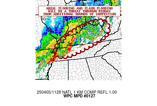
mesoscale precipitation discussion 0127
nws weather prediction center college park md
1149 pm edt sun apr 17 2016
areas affected... texas
concerning... heavy rainfall... flash flooding likely
valid 180349z - 180949z
summary... mcv/cold pool within warm sector to establish reinforced boundary with the potential for extreme totals and life threatening flash flooding through the overnight.
discussion... excellent upper level divergence/diffluence exists across e tx to maintain mcs complex with well defined mcv lifting into ne texas... with a convective qlcs with efficient high rates up to 2.0"/hr and will continue to pose a short term flash flooding threat though it is moving into higher guidance... this area will also be increasingly obstructed by the complex developing south of it across near/nw of the houston metro attm.
in the low levels the broad 40-45kt sely llj had been transporting high moisture into the larger complex toward the north... but enough convergence lead to convective development which due to latent heat release developed a decent mcv and cold pool... this mcv lifting north with attendant cold pool/outflow boundary has established a convective line from colorado to montgomery county which due to orientation with the mcv to the north should continue to reinforce the alignment of the boundary and act as a nearly stationary convective initiation point for deep mst flux with tpws to 1.75-2.0" and sbcapes maintained from the gulf in the 1500-2000 j/kg range within a environment for warm cloud hvy rainfall production with rates in excess of 3"/hr with potential for 4"/hr or higher not out of the realm of possibility. with little movement... extreme totals and life threatening flash flooding are likely.
the signal for 6hr totals in excess of 7" has been fairly consistent within large scale guidance for a few days... just not sure in exact location. recent hi-res cams... such as the hrrr and esrl exp. hurr over 9" by 10z... though given radar trends this is a few counties north and west of current setup.
gallina
...please see http://www.wpc.ncep.noaa.gov for graphic product...
attn...wfo...ewx...fwd...hgx...lch...shv...
attn...rfc...wgrfc...
Last edited by unome on Sun Apr 17, 2016 11:08 pm, edited 1 time in total.
-
DoctorMu
- Posts: 7783
- Joined: Sun Jun 28, 2015 11:58 am
- Location: College Station
- Contact:
BULLETIN - EAS ACTIVATION REQUESTED
FLASH FLOOD WARNING
NATIONAL WEATHER SERVICE HOUSTON/GALVESTON TX
1036 PM CDT SUN APR 17 2016
THE NATIONAL WEATHER SERVICE IN LEAGUE CITY HAS ISSUED A
* FLASH FLOOD WARNING FOR...
NORTHEASTERN COLORADO COUNTY IN SOUTHEASTERN TEXAS...
CENTRAL WALLER COUNTY IN SOUTHEASTERN TEXAS...
WESTERN HARRIS COUNTY IN SOUTHEASTERN TEXAS...
EASTERN AUSTIN COUNTY IN SOUTHEASTERN TEXAS...
* UNTIL 130 AM CDT
* AT 1034 PM CDT...DOPPLER RADAR AND AUTOMATED RAIN GAUGES INDICATED
THUNDERSTORMS PRODUCING HEAVY RAIN ACROSS THE WARNED AREA. TWO TO
FOUR INCHES OF RAIN HAVE ALREADY FALLEN. FLASH FLOODING IS
EXPECTED TO BEGIN SHORTLY.
* SOME LOCATIONS THAT WILL EXPERIENCE FLOODING INCLUDE...
SEALY...PRAIRIE VIEW...BELLVILLE...WALLER...PINE ISLAND...SAN FELIPE...
PATTISON...MONAVILLE AND CAT SPRING.
-
DoctorMu
- Posts: 7783
- Joined: Sun Jun 28, 2015 11:58 am
- Location: College Station
- Contact:
unome: that outflow boundary and border between the cold pool and warm air is creating a heck of a lot of lift.
The meso in Waller and Austin Cos. is being fed by a QPF firehose. Note that incoming moisture from the Gulf is expanding the southern border retrograde back to I-10 and south while the northern border continues to lift north. We have an expanding, extreme situation.
The meso in Waller and Austin Cos. is being fed by a QPF firehose. Note that incoming moisture from the Gulf is expanding the southern border retrograde back to I-10 and south while the northern border continues to lift north. We have an expanding, extreme situation.
-
- Information
-
Who is online
Users browsing this forum: Bing [Bot], Google [Bot], Semrush [Bot] and 44 guests