Page 9 of 11
Re: NOVEMBER 2018: Slow Warming Trend/Thanksgiving Outlook
Posted: Wed Nov 14, 2018 8:49 pm
by Cpv17
Katdaddy wrote:Ready for Spring and Summer 2019 however if Winter 2018-2019 brings some snow; I will enjoy and stay warm.
It already has once lol I believe a lot more will come. This setup is looking fantastic!
Re: NOVEMBER 2018: Slow Warming Trend/Thanksgiving Outlook
Posted: Thu Nov 15, 2018 6:14 am
by unome
Hooks hasn't reported since last night
https://www.wrh.noaa.gov/zoa/getobext.php?sid=KDWH
https://www.wunderground.com/wundermap reads anywhere from 28 to 34 for my immediate area
cheapo patio thermometer reads 34, but it's on the house wall, which is likely warmer
I'm done with winter for now, bring back my sun & warming rays !
Re: NOVEMBER 2018: Slow Warming Trend/Thanksgiving Outlook
Posted: Thu Nov 15, 2018 6:40 am
by snowman65
Now that this big freeze event will be over today, when is the NEXT one?? That's all I want to know....lol....keep on bringin em....
Re: NOVEMBER 2018: Slow Warming Trend/Thanksgiving Outlook
Posted: Thu Nov 15, 2018 7:42 am
by srainhoutx
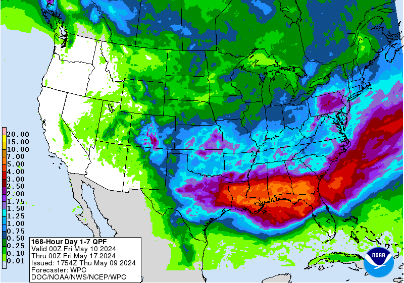
The forecast for the very busy Thanksgiving travel period looks messy across the Texas Gulf Coast. While there remains some uncertainty this far out, the computer guidance does indicate a Coastal trough develops near Brownsville after the next cold front arrives Sunday. That trough appears to deepen Tuesday and into Wednesday with showers and thunderstorms developing and some potential for heavy rainfall depending on the actual track of a strong Coastal Low. Travel may be impacted particularly Wednesday into Thanksgiving Day and possibly extending into next Friday. We will be monitoring carefully as many of us have travel plans. Stay Tuned!
Re: NOVEMBER 2018: Slow Warming Trend/Thanksgiving Outlook
Posted: Thu Nov 15, 2018 8:45 am
by jasons2k
Saturday: Mostly Sunny and 70F. I can't wait!!!
Re: NOVEMBER 2018: Slow Warming Trend/Thanksgiving Outlook
Posted: Thu Nov 15, 2018 10:55 am
by MontgomeryCoWx
December is starting to look very cold and stormy! We may be locking in an epic Winter in a couple weeks.
Long range has flipped to much Colder.
Re: NOVEMBER 2018: Slow Warming Trend/Thanksgiving Outlook
Posted: Thu Nov 15, 2018 11:07 am
by srainhoutx
MontgomeryCoWx wrote:December is starting to look very cold and stormy! We may be locking in an epic Winter in a couple weeks.
Long range has flipped to much Colder.
The longer range guidance will be playing cat up with these new Updated Teleconnection Indices. Impressive Hemispheric Pattern developing as we end November and begin December. Siberia is running well below normal temperature wise for mid November. A massive Northern latitude blocking regime establishes a very negative NAO and AO. That positive PNA suggests a Western Ridge and a negative EPO delivers storms system at the higher latitudes up and over the Bering Sea/Western Alaska dumping cold air across the North Pole into North America. Above normal snowfall across the Northern Hemisphere also suggests less airmass modification as we roll forward in time.
Re: NOVEMBER 2018: Slow Warming Trend/Thanksgiving Outlook
Posted: Thu Nov 15, 2018 12:04 pm
by snowman65
MontgomeryCoWx wrote:December is starting to look very cold and stormy! We may be locking in an epic Winter in a couple weeks.
Long range has flipped to much Colder.
I hope you're right!!
Re: NOVEMBER 2018: Slow Warming Trend/Thanksgiving Outlook
Posted: Thu Nov 15, 2018 12:54 pm
by CrashTestDummy
And I'm wishcasting that the models are wrong! We finally got a good crop of oranges and grapefruit this year. Praying we don't get a setback with freezing weather this fall/winter.
Re: NOVEMBER 2018: Slow Warming Trend/Thanksgiving Outlook
Posted: Thu Nov 15, 2018 1:51 pm
by snowman65
The longer range guidance will be playing cat up with these new Updated Teleconnection Indices. Impressive Hemispheric Pattern developing as we end November and begin December. Siberia is running well below normal temperature wise for mid November. A massive Northern latitude blocking regime establishes a very negative NAO and AO. That positive PNA suggests a Western Ridge and a negative EPO delivers storms system at the higher latitudes up and over the Bering Sea/Western Alaska dumping cold air across the North Pole into North America. Above normal snowfall across the Northern Hemisphere also suggests less airmass modification as we roll forward in time.[/quote]
This is what I read: The longer range ndfgoijhdgh[ne[hoerhoh Novemebr and begin December. A massive i;apiohvihvfqhphnpuihafguiomvehp[iomhcwaemhe. Above normal snowfall.......


Re: NOVEMBER 2018: Slow Warming Trend/Thanksgiving Outlook
Posted: Thu Nov 15, 2018 2:18 pm
by Cpv17
snowman65 wrote:The longer range guidance will be playing cat up with these new Updated Teleconnection Indices. Impressive Hemispheric Pattern developing as we end November and begin December. Siberia is running well below normal temperature wise for mid November. A massive Northern latitude blocking regime establishes a very negative NAO and AO. That positive PNA suggests a Western Ridge and a negative EPO delivers storms system at the higher latitudes up and over the Bering Sea/Western Alaska dumping cold air across the North Pole into North America. Above normal snowfall across the Northern Hemisphere also suggests less airmass modification as we roll forward in time.
This is what I read: The longer range ndfgoijhdgh[ne[hoerhoh Novemebr and begin December. A massive i;apiohvihvfqhphnpuihafguiomvehp[iomhcwaemhe. Above normal snowfall.......


[/quote]
Just know that the temperatures of the oceans play a very important role in the weather globally, not just here.
Re: NOVEMBER 2018: Slow Warming Trend/Thanksgiving Outlook
Posted: Thu Nov 15, 2018 2:52 pm
by srainhoutx
Sorry snowman65. I was in a hurry and didn't explain myself very well. I'll dial back the technical jargon and keep it readable in the days ahead. Hectic times these days with everything with the Weather Forum future issues and Thanksgiving Holidays speeding toward us...

Re: NOVEMBER 2018: Slow Warming Trend/Thanksgiving Outlook
Posted: Thu Nov 15, 2018 3:09 pm
by Cpv17
All of the 12z model runs today backed away from cold air. The only model run today that showed any potential for Artic air was the 6z FV3. Plenty of rain around though for the next couple weeks.
Re: NOVEMBER 2018: Slow Warming Trend/Thanksgiving Outlook
Posted: Thu Nov 15, 2018 3:54 pm
by tireman4
NWS Houston Tonight Forecast
Re: NOVEMBER 2018: Slow Warming Trend/Thanksgiving Outlook
Posted: Thu Nov 15, 2018 4:05 pm
by Cpv17
WPC keeps most of the rain offshore for next week.

Re: NOVEMBER 2018: Slow Warming Trend/Thanksgiving Outlook
Posted: Fri Nov 16, 2018 6:52 am
by cperk
srainhoutx wrote:MontgomeryCoWx wrote:December is starting to look very cold and stormy! We may be locking in an epic Winter in a couple weeks.
Long range has flipped to much Colder.
The longer range guidance will be playing cat up with these new Updated Teleconnection Indices. Impressive Hemispheric Pattern developing as we end November and begin December. Siberia is running well below normal temperature wise for mid November. A massive Northern latitude blocking regime establishes a very negative NAO and AO. That positive PNA suggests a Western Ridge and a negative EPO delivers storms system at the higher latitudes up and over the Bering Sea/Western Alaska dumping cold air across the North Pole into North America. Above normal snowfall across the Northern Hemisphere also suggests less airmass modification as we roll forward in time.
This is why we need our forum and I'm willing to contribute to keep if that's what it comes down to.
Re: NOVEMBER 2018: Slow Warming Trend/Thanksgiving Outlook
Posted: Fri Nov 16, 2018 8:58 am
by jasons2k
The AFD was very detailed. Here is sorta the summary at the end:
Fortunately the models continue to show the highest rainfall amounts well off the
coast in the Gulf that the area should avoid the heavy rainfall
threat. That`s not to say we will not get any rain in the area
because we are still looking at a good 1 to 3 inches of rain
across the area for the 5 day period next week. It just looks like
those isolated higher amounts will stay of the coast and not be a
problem for the area. Keep in mind this is still the extended
forecast and we`ve seen the second shortwave trough change in
timing for Wed/Thur quite a bit with the last day or two`s worth
of model runs.
Re: NOVEMBER 2018: Slow Warming Trend/Thanksgiving Outlook
Posted: Fri Nov 16, 2018 9:22 am
by tireman4
srainhoutx wrote:Sorry snowman65. I was in a hurry and didn't explain myself very well. I'll dial back the technical jargon and keep it readable in the days ahead. Hectic times these days with everything with the Weather Forum future issues and Thanksgiving Holidays speeding toward us...

It happens to all pro mets Srain. Even Dr. Frank was chastised about meteorological jargon..LOL ( USA Today Weather book about his dealings with the public after Camille)...lol..we love ya
Re: NOVEMBER 2018: Slow Warming Trend/Thanksgiving Outlook
Posted: Fri Nov 16, 2018 9:24 am
by tireman4
HGX Weather Forecast...
Re: NOVEMBER 2018: Slow Warming Trend/Thanksgiving Outlook
Posted: Fri Nov 16, 2018 10:42 am
by BlueJay
Just got done un-blanketing in the yard. It looks like all my plants, with the exception of the sweet potato vine, survived our first freeze.
So glad to see the sun.
