Page 10 of 12

Re: May 2017: Memorial Day/End Of May Outlook

Posted: Sun May 28, 2017 4:52 pm
by DoctorMu
Area Forecast Discussion
National Weather Service Houston/Galveston TX
346 PM CDT Sun May 28 2017

.DISCUSSION...
Line of storms likely about to fire along a frontal boundary
draped across ncntl Texas. As previously talked about, the atmos
is very unstable in advance w/ high CAPES and low LI`s. Anticipate
some severe storms to emerge as they make their way into se Tx
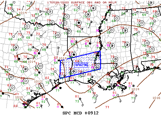
this evening. Severe Thunderstorm Watch is in effect generally
northwest of a Columbus-Livingston line until 10 pm.
Dependent on
strength/movement trends, we may end up needing to add the metro
area to the watch as well. Aircraft soundings around there still
indicate some capping at 700mb, but has eroded some since this
morning.
Almost all hazards are are the table with hail/winds the
primary threat, followed by localized heavy rain amounts & rates,
and finally a low (but non-zero) chance of a tornado.

This storm complex will send a boundary southward, and this will
determine the overall threat and/or locations for future hazardous
wx as another shortwave makes its way in from the sw late tonight
and Monday. Ongoing thinking continues to point to the southern
1/3 of the region being the more favored spot, but if a boundary
ends up well off the coast later tonight, pops and qpf amounts
will need to be adjusted downward Monday. Unfortunately, but not
unexpectedly, there isn`t a good model consensus.

Coastal troffiness is expected into midweek. Deeper moisture and convergence
along the trof (along with some passing upper impulses) will probably
trigger overnight and morning precip closer to the coast followed
by inland expansion with daytime heating. Looks like the trof
could wash out and we`d lose a surface focusing mechanism later in
the week, but atmos still looks plenty moist for higher end &
diurnally driven pops through the remainder of the work week.

There will probably be some locations we`ll need to keep an eye on
as we go thru the week as rainfall adds up. As ground gets more
saturated it won`t be able to absorb as much water, and higher
rain rates themselves could become more of a problem in regards to
flash flooding as this occurs. 47

Re: May 2017: Memorial Day/End Of May Outlook

Posted: Sun May 28, 2017 4:54 pm
by DoctorMu
Image

Image

Re: May 2017: Memorial Day/End Of May Outlook

Posted: Sun May 28, 2017 7:24 pm
by StormOne
KHGX radar down. These things always go down at the perfect times!

Re: May 2017: Memorial Day/End Of May Outlook

Posted: Sun May 28, 2017 7:39 pm
by DoctorMu
The line of storms is coming together just north of Bryan/College Station:

Image

Image

http://www.accuweather.com/en/us/easter ... dar?play=1


Severe Thunderstorm Warning
TXC041-051-185-290100-
/O.NEW.KHGX.SV.W.0129.170529T0028Z-170529T0100Z/

BULLETIN - IMMEDIATE BROADCAST REQUESTED
Severe Thunderstorm Warning
National Weather Service Houston/Galveston TX
728 PM CDT SUN MAY 28 2017

The National Weather Service in League City has issued a

* Severe Thunderstorm Warning for...
Burleson County in southeastern Texas...
Northwestern Grimes County in southeastern Texas...
Brazos County in southeastern Texas...

* Until 800 PM CDT.

* At 727 PM CDT, a severe thunderstorm was located 9 miles north of
Caldwell, moving southeast at 20 mph. Dime size hail has been
reported south of Goldthwaite.

HAZARD...60 mph wind gusts and quarter size hail.

SOURCE...Radar indicated.

IMPACT...Hail damage to vehicles is expected. Expect wind damage
to roofs, siding, and trees.

* Locations impacted include...
College Station, Bryan, Caldwell, Somerville, Snook, Kurten, Wixon
Valley, Millican, Kyle Field, Lyons, Deanville, Chriesman, Wellborn
and Carlos.

PRECAUTIONARY/PREPAREDNESS ACTIONS...

For your protection move to an interior room on the lowest floor of a
building.

&&

Re: May 2017: Memorial Day/End Of May Outlook

Posted: Sun May 28, 2017 7:44 pm
by DoctorMu
StormOne wrote:KHGX radar down. These things always go down at the perfect times!

This may help. Central TX, East TX radar overlaps with some of the Hou area. Galveston and the immediate coast are a reach.

http://www.accuweather.com/en/us/easter ... nteractive

Re: May 2017: Memorial Day/End Of May Outlook

Posted: Sun May 28, 2017 7:48 pm
by mckinne63
Chance of rain for tomorrow was 80% this morning, now it's 60%.

Re: May 2017: Memorial Day/End Of May Outlook

Posted: Sun May 28, 2017 7:59 pm
by unome
NWS EDD: http://tinyurl.com/yd83mkq3
or
Weather and Hazards Data Viewer: http://www.wrh.noaa.gov/map/?&zoom=7&sc ... opacity=70

this twitter feed lists wpc & spc alerts for our area as well as hgx info https://twitter.com/iembot_hgx

Re: May 2017: Memorial Day/End Of May Outlook

Posted: Sun May 28, 2017 8:15 pm
by srainhoutx
The techs are working on our local radar. Unfortunately it may be tomorrow according to HGX. The frontal boundary is hardly moving. For those under the impressive squal line, heavy rainfall rates are certainly possible. Radar suggests Crocket has received almost 6 inches.
.so far

Re: May 2017: Memorial Day/End Of May Outlook

Posted: Sun May 28, 2017 8:20 pm
by StormOne
KCRP broke down just now too. Bad timing.

Re: May 2017: Memorial Day/End Of May Outlook

Posted: Sun May 28, 2017 8:24 pm
by mcheer23
mckinne63 wrote:Chance of rain for tomorrow was 80% this morning, now it's 60%.

Still at 80.

Re: May 2017: Memorial Day/End Of May Outlook

Posted: Sun May 28, 2017 8:25 pm
by brooksgarner
What's up, guys? Happy Sunday night. Just dropping in to see what's going on in the forum. The rain is all mesoscale driven. So tough to try to tell people that we can't predict the timing/amount/location exactly. "But, it's tomorrow's forecast! You can't predict 1 stinkin' day into the future?" "Nope. Sorry." haha

I saw someone had posted about the HGX radar site. In the mean time, it's a good time to play around with the various IR scans of GOES-16 --> https://weather.msfc.nasa.gov/goes/abi/ ... and14.html :D

Re: May 2017: Memorial Day/End Of May Outlook

Posted: Sun May 28, 2017 8:35 pm
by unome

Re: May 2017: Memorial Day/End Of May Outlook

Posted: Sun May 28, 2017 8:47 pm
by srainhoutx
This cell is worth monitoring. Seeing reports of some impressive downburst winds.

BULLETIN - IMMEDIATE BROADCAST REQUESTED
Severe Thunderstorm Warning
National Weather Service Houston/Galveston TX
840 PM CDT SUN MAY 28 2017

The National Weather Service in League City has issued a

* Severe Thunderstorm Warning for...
Burleson County in southeastern Texas...
Northwestern Washington County in southeastern Texas...
Southwestern Brazos County in southeastern Texas...

* Until 930 PM CDT.

* At 840 PM CDT, a severe thunderstorm was located near Somerville,
or 13 miles southeast of Caldwell, moving east at 30 mph.

HAZARD...70 mph wind gusts.

SOURCE...Radar indicated.

IMPACT...Expect considerable tree damage. Damage is likely to
mobile homes, roofs, and outbuildings.

* Locations impacted include...
Western College Station, southwestern Bryan, Caldwell, Somerville,
Snook, Lake Somerville Dam, Lyons, Deanville, Independence and
Quarry.


Re: May 2017: Memorial Day/End Of May Outlook

Posted: Sun May 28, 2017 8:58 pm
by StormOne
Thanks so much for the GOES-16 links, Brooks and Unome. Really impressive! The KLCH and KGRK sites are covering about 2/3 of our WFO fairly well, we should survive.

Re: May 2017: Memorial Day/End Of May Outlook

Posted: Sun May 28, 2017 9:03 pm
by unome
lightning is lighting up the sky to the NW

http://atmo.tamu.edu/ciams/lma/network_loop.html

Re: May 2017: Memorial Day/End Of May Outlook

Posted: Sun May 28, 2017 9:06 pm
by srainhoutx
Flash Flood Statement
National Weather Service Houston/Galveston TX
903 PM CDT SUN MAY 28 2017

Houston TX-
903 PM CDT SUN MAY 28 2017

...THE FLASH FLOOD WARNING REMAINS IN EFFECT UNTIL 1015 PM CDT FOR
NORTHERN HOUSTON COUNTY...

At 901 PM CDT, local law enforcement reported heavy rain due to a
thunderstorm over Crockett. Many road closures have been reported
due to water over the road in Crockett including 6th street...4th
street...E Goliad...E Loop...S Loop...19 South...and 7 East. 4 to 6
inches of rain have fallen. Flash flooding is already ongoing.

Some locations that will experience flooding include...
Crockett, Grapeland, Kennard, Latexo and Weches.


Re: May 2017: Memorial Day/End Of May Outlook

Posted: Sun May 28, 2017 9:11 pm
by srainhoutx
Alright gang, I am out for the evening. Thanks to all of you that are faithful to keeping our folks updated... ;)

BULLETIN - IMMEDIATE BROADCAST REQUESTED
Severe Thunderstorm Warning
National Weather Service Houston/Galveston TX
909 PM CDT SUN MAY 28 2017

The National Weather Service in League City has issued a

* Severe Thunderstorm Warning for...
Southwestern Trinity County in southeastern Texas...
Eastern Grimes County in southeastern Texas...
Northwestern Montgomery County in southeastern Texas...
Southwestern Houston County in southeastern Texas...
Eastern Madison County in southeastern Texas...
Walker County in southeastern Texas...

* Until 1000 PM CDT.

* At 908 PM CDT, severe thunderstorms were located along a line
extending from 9 miles southwest of Austonio to near Navasota,
moving east at 30 mph.

HAZARD...60 mph wind gusts and penny size hail.

SOURCE...Radar indicated.

IMPACT...Expect damage to roofs, siding, and trees.

* Locations impacted include...
Huntsville, Willis, Trinity, New Waverly, Lovelady, Montgomery,
Riverside, Anderson, Huntsville State Park, Crabbs Prairie, Dacus,
Roans Prairie and Richards.

Re: May 2017: Memorial Day/End Of May Outlook

Posted: Sun May 28, 2017 9:22 pm
by unome
https://twitter.com/iembot_hgx/status/8 ... 6424230912
http://www.spc.noaa.gov/products/md/2017/md0912.html

Image
Mesoscale Discussion 0912
NWS Storm Prediction Center Norman OK
0916 PM CDT Sun May 28 2017

Areas affected...LA...Western MS

Concerning...Severe Thunderstorm Watch 296...

Valid 290216Z - 290315Z

The severe weather threat for Severe Thunderstorm Watch 296
continues.

SUMMARY...Severe threat will shift south across WW296 over the next
few hours.

DISCUSSION...Slowly expanding MCS has propagated across the northern
half of LA and the leading edge of this complex will soon shift east
of the MS River. This leading edge is oriented perpendicular to the
mean flow aloft which could enhance damaging wind potential as it
moves east, though instability is considerably weaker across MS than
LA. Trailing convection across central/western portions of the
watch has now been undercut by outflow and marginally severe hail
seems the primary threat with this elevated activity.

..Darrow.. 05/29/2017

...Please see http://www.spc.noaa.gov for graphic product...

ATTN...WFO...JAN...LIX...LCH...SHV...HGX...

LAT...LON 31199457 31939113 30629113 29889457 31199457

Re: May 2017: Memorial Day/End Of May Outlook

Posted: Sun May 28, 2017 10:01 pm
by unome
https://twitter.com/iembot_hgx/status/8 ... 2233007104

Special Weather Statement
National Weather Service Houston/Galveston TX
956 PM CDT SUN MAY 28 2017

TXZ177>179-198>200-212-290330-
San Jacinto TX-Walker TX-Grimes TX-Waller TX-Liberty TX-Polk TX-
Montgomery TX-
956 PM CDT SUN MAY 28 2017

...SIGNIFICANT WEATHER ADVISORY FOR SOUTHEASTERN GRIMES...
MONTGOMERY...SAN JACINTO...NORTHEASTERN WALLER...NORTHWESTERN
LIBERTY...SOUTHERN POLK AND WALKER COUNTIES UNTIL 1030 PM CDT...

At 956 PM CDT, Doppler radar was tracking strong thunderstorms along
a line extending from 9 miles southeast of Bedias to 8 miles north of
Votaw. Movement was south at 30 mph.

Winds in excess of 40 mph will be possible with these storms.

Locations impacted include...
Conroe, Huntsville, Cleveland, Willis, Livingston, Pinehurst, The
Woodlands, Shepherd, Panorama Village, Shenandoah, Onalaska,
Splendora, Patton Village, Roman Forest, Magnolia, Woodbranch, Cut
And Shoot, New Waverly, Coldspring and Hardin.

PRECAUTIONARY/PREPAREDNESS ACTIONS...

Frequent cloud to ground lightning is occurring with these storms.
Lightning can strike 10 miles away from a thunderstorm. Seek a safe
shelter inside a building or vehicle.

These storms may intensify, so be certain to monitor local radio
stations and available television stations for additional information
and possible warnings from the National Weather Service.

&&

A severe thunderstorm watch remains in effect until 1100 PM CDT for
southeastern Texas.

LAT...LON 3049 9454 3049 9473 3017 9462 3020 9580
3025 9581 3023 9605 3089 9560 3086 9541
3083 9539 3084 9534 3086 9532 3084 9525
3080 9517 3085 9511 3081 9461
TIME...MOT...LOC 0256Z 015DEG 26KT 3068 9582 3056 9464

$$

Hathaway

Re: May 2017: Memorial Day/End Of May Outlook

Posted: Sun May 28, 2017 10:06 pm
by unome
Local Storm Reports, surrounding areas

https://nwschat.weather.gov/lsr/#LCH,SH ... 90303/1101