Page 10 of 13
Re: April 2018- Warming Trend/Weak Front Thursday/Stormy Wee
Posted: Tue Apr 17, 2018 5:53 pm
by Cromagnum
That's 4 days out, and folks lately have struggled with today/tomorrow. I'll look at the forecast Friday when I get home from work.
Re: April 2018- Cool Front Wednesday/Weekend Rain Chances
Posted: Wed Apr 18, 2018 5:32 am
by Katdaddy
A warm and humid day with showers possible this afternoon and night. A cool front will move across SE TX tonight and early tomorrow morning bringing cooler and drier weather for Thursday and Friday. Rain and thunderstorm chances increase Friday night through Saturday night ahead of the next cold on Sunday.
Re: April 2018- Cool Front Wednesday/Weekend Rain Chances
Posted: Wed Apr 18, 2018 6:59 am
by srainhoutx
I am not seeing much hope for any meaningful rainfall this weekend and the severe thunderstorms chances even for Central Texas are diminishing day by day as the available moisture decreases and jet structures appear out of sync. Maybe by Friday things will change, but at this time a quarter to possibly an inch of rainfall with isolated higher amounts where any thunderstorms do develop along the cold front late Saturday night into early Sunday morning look reasonable as of Wednesday morning.
Re: April 2018- Cool Front Wednesday/Weekend Rain Chances
Posted: Wed Apr 18, 2018 7:36 am
by jasons2k
Yeah, this is a case when the trend is not your friend if you want rain. Huge disappointment as this system looked so promising.
Re: April 2018- Cool Front Wednesday/Weekend Rain Chances
Posted: Wed Apr 18, 2018 7:54 am
by srainhoutx
Wednesday morning briefing from Jeff:
weak cool front will slide into the area on Thursday and stall near the coast resulting in cooler conditions both Thursday and Friday. Could see a few showers with the boundary Thursday, but strong capping aloft looks to prevent much in the way of thunderstorms.
Main forecast period continues to be this weekend as a strong upper level storm system will move across the state. Recent global model runs are still not in very good agreement on the exact track of this system nor the placement of critical upper level features which could either enhance or hinder thunderstorm development. Coastal boundary on Friday looks to only slowly return northward, so the quality of moisture return is also coming into question. Overall timing remains from late Saturday afternoon through early Sunday morning…with a tendency to support to slower solutions.
Severe threat and heavy rainfall still look possible with this system, but unsure on the coverage and potential severity at this range given the conflicting data on the placement of upper level features over the area Saturday evening. Hopefully things will firm up some over the next 24-48 hours.
Re: April 2018- Cool Front Wednesday/Weekend Rain Chances
Posted: Wed Apr 18, 2018 8:54 am
by ticka1
In 2016 and 2009 we had large amounts of rain and flooding . Saw it on my FB history.
Re: April 2018- Cool Front Wednesday/Weekend Rain Chances
Posted: Wed Apr 18, 2018 9:15 am
by srainhoutx
ticka1 wrote:In 2016 and 2009 we had large amounts of rain and flooding . Saw it on my FB history.
Tax Day Flood was 2 years ago yesterday when I measured over 20 inches in 12 hours. In 2009, a stationary thunderstorm complex developed during the overnight hours and dropped almost 17 inches in about hours in my back yard flooding Hearthstone and Bear Creek Subdivisions among many other.
Re: April 2018- Cool Front Wednesday/Weekend Rain Chances
Posted: Wed Apr 18, 2018 10:18 am
by jasons2k
Jeff has also resorted to using the word "still" in his discussion. Famous last words before busting.
Re: April 2018- Cool Front Wednesday/Weekend Rain Chances
Posted: Wed Apr 18, 2018 10:19 am
by jasons2k
srainhoutx wrote:ticka1 wrote:In 2016 and 2009 we had large amounts of rain and flooding . Saw it on my FB history.
Tax Day Flood was 2 years ago yesterday when I measured over 20 inches in 12 hours. In 2009, a stationary thunderstorm complex developed during the overnight hours and dropped almost 17 inches in about hours in my back yard flooding Hearthstone and Bear Creek Subdivisions among many other.
Anyone have time to dig-up this thread? It would be worth revisiting...
Re: April 2018- Cool Front Wednesday/Weekend Rain Chances
Posted: Wed Apr 18, 2018 10:45 am
by ccbluewater
Tax Day flood was an intense night! I remember when those storms started to explode to my SW and started training over my house at the time in Cypress/Copperfield area, the lightning was just relentless. My son was 2 years old at the time, and has been terrified of thunder/lightning ever since that night. A house a couple blocks away burned down, and a client we work with had his sons house burn down in Blackhorse from a lightning strike that night also. I believe we had 16.5 inches of rain from 8PM-6AM. Never thought we would see that much rain in a short period of time again for a while.. Wrong!
Re: April 2018- Cool Front Wednesday/Weekend Rain Chances
Posted: Wed Apr 18, 2018 11:49 am
by Ounce
jasons wrote:srainhoutx wrote:ticka1 wrote:In 2016 and 2009 we had large amounts of rain and flooding . Saw it on my FB history.
Tax Day Flood was 2 years ago yesterday when I measured over 20 inches in 12 hours. In 2009, a stationary thunderstorm complex developed during the overnight hours and dropped almost 17 inches in about hours in my back yard flooding Hearthstone and Bear Creek Subdivisions among many other.
Anyone have time to dig-up this thread? It would be worth revisiting...
This starts on the Saturday before.
http://forums.khou.com/viewtopic.php?f= ... 6&start=90
Page 10 of the April 2016 thread.
Re: April 2018- Cool Front Wednesday/Weekend Rain Chances
Posted: Thu Apr 19, 2018 7:33 am
by srainhoutx
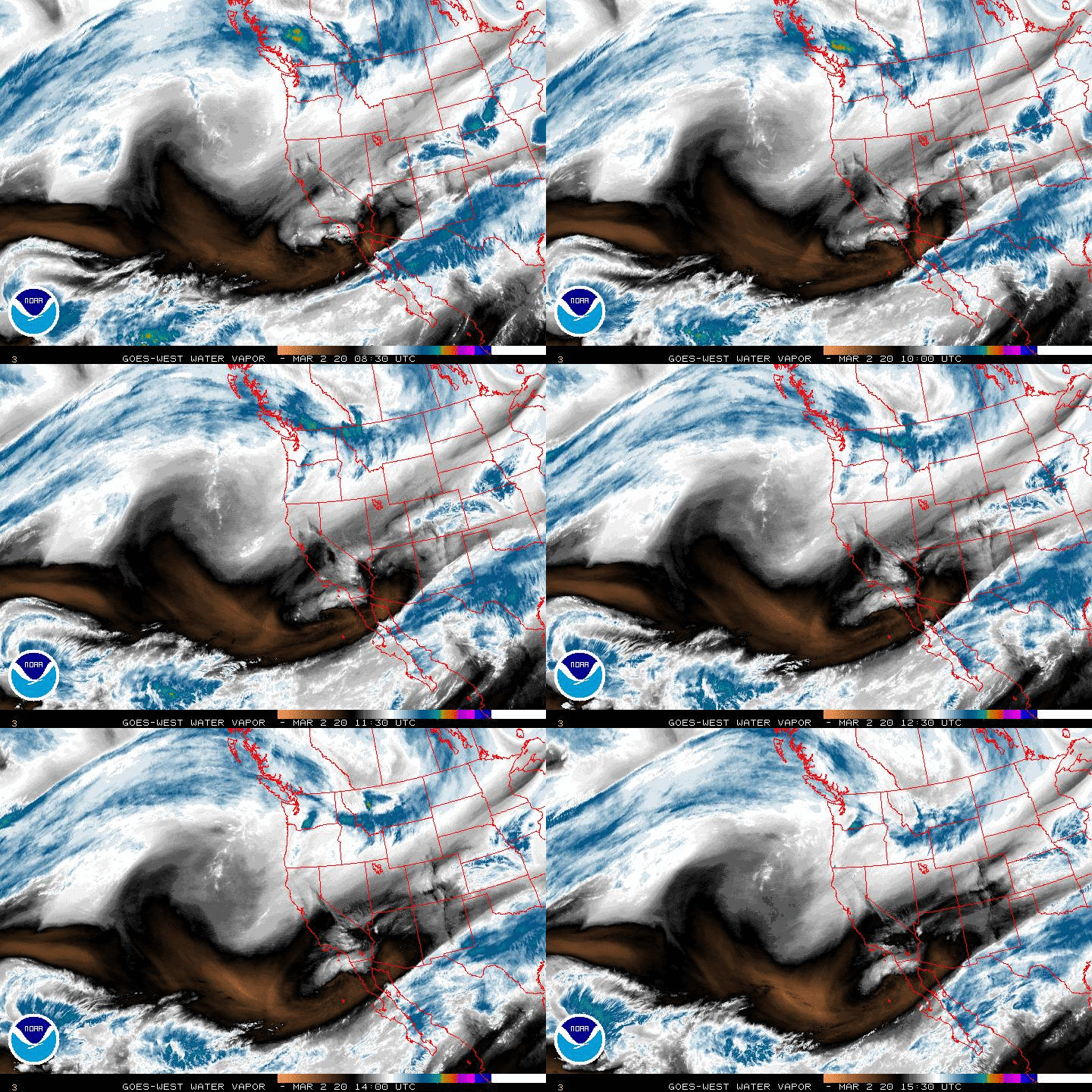
Still uncertainty regarding the sensible weather this morning for Saturday into early Sunday morning. Our bowling ball upper low is nearing the California Coast and should be fully onshore later today. The ECMWF/GFS continue to decrease both severe storms and rainfall potential as the frontal boundary that has brought us cooler weather this morning may be a bit slower to return N to increase enough available moisture and instability before the upper low passes and a strong front arrives Sunday morning.

The latest NAM solutions are a bit more aggressive with rainfall and some stronger storms, but right now it appears to be an outlier solution. We will continue to monitor the trends through Saturday morning for any surprises in the sensible weather forecast which is particularly important with the Funeral for Barbara Bush on Saturday here in Houston.
Re: April 2018- Cool Front Wednesday/Weekend Rain Chances
Posted: Thu Apr 19, 2018 8:09 am
by tireman4
Weekend Forecast
Re: April 2018- Cool Front Wednesday/Weekend Rain Chances
Posted: Thu Apr 19, 2018 8:46 am
by tireman4
Severe Weather Forecast This Weekend
Re: April 2018- Cool Front Wednesday/Weekend Rain Chances
Posted: Thu Apr 19, 2018 12:14 pm
by DoctorMu
Nearly Chamber of Commerce weather in College Station today. A little windy, but it's Texas and I'm used to that aspect.
Most of the precip. Sat/Sun is projected N of the Houston area on GFS and Canadian runs. Maybe 0.5-1 in. of rain in CLL.

Re: April 2018- Cool Front Wednesday/Weekend Rain Chances
Posted: Thu Apr 19, 2018 5:34 pm
by jasons2k
Update from Jeff:
Models have finally started to come into better agreement on the weekend storm system and overall it appears the things will not be lining up to produce much severe weather nor excessive rainfall.
Moisture return will begin on Friday afternoon and a few showers can be expected across the area by Saturday morning as the moist layer deepens. A warm front will cross the area on Saturday and while thunderstorms will be possible with this feature…especially NNE/NE of Houston, overall instability is low on Saturday which should keep the severe threat low. The actual cold front will move across the area Saturday night with a line of showers and thunderstorms. While a couple of severe thunderstorms will be possible, still not seeing much instability and the strongest forcing (lift) is not really in phase with the surface front…this is somewhat similar to last weekend.
Rainfall amounts will average .50 to 1.5 inches over the area with isolated totals upwards of 2.0 inches. Not expecting any flooding concerns with these amounts given the generally dry ground conditions.
Showers will linger into early Sunday morning before a drier air mass moves into the region with clearing skies by midday Sunday.
Re: April 2018- Cool Front Wednesday/Weekend Rain Chances
Posted: Fri Apr 20, 2018 5:39 am
by Katdaddy
Another cool April morning with temps in the 50s across SE TX. Highs around 70F today with high and mid level clouds. The SPC has a marginal risk area for Central and N portions of SE TX Saturday evening and night.
Re: April 2018- Barbara Bush Public Viewing/Private Funeral
Posted: Fri Apr 20, 2018 8:50 am
by tireman4
000
FXUS64 KHGX 201109
AFDHGX
Area Forecast Discussion
National Weather Service Houston/Galveston TX
609 AM CDT Fri Apr 20 2018
.AVIATION [12Z TAF Issuance]...
VFR through most of the forecast period with high clouds.
Northeasterly winds expected to strengthen through the morning
and become easterly. Winds will continue to veer to southeasterly
tonight. Overnight, ceilings will come down, reaching MVFR around
or after midnight. Outside shot at some showers tomorrow morning,
but beyond the forecast period for all but IAH. Given uncertainty
in moistening the atmosphere, not quite enough confidence for a
PROB30 at this time.
Luchs
Re: April 2018- Barbara Bush Public Viewing/Private Funeral
Posted: Fri Apr 20, 2018 1:01 pm
by unome
Re: April 2018- Barbara Bush Public Viewing/Private Funeral
Posted: Fri Apr 20, 2018 1:58 pm
by tireman4
073
FXUS64 KHGX 201712
AFDHGX
Area Forecast Discussion
National Weather Service Houston/Galveston TX
1212 PM CDT Fri Apr 20 2018
.AVIATION...
Mainly cirrus expected this afternoon into this evening but there
is a weak short wave over Central Texas that is generating some
very light rain. This feature is moving east into weak riding over
SE TX. The precip is expected to weaken and dissipate before
reaching area TAF sites. Low level moisture begins to increase
overnight as a warm front approaches from the south and MVFR
ceilings will develop between 06-09z with perhaps some weak WAA
showers or patchy light rain/drizzle developing by sunrise. Leaned
a bit toward the HiRes ARW and NMM for early morning precip. Fcst
soundings support a mix of IFR/MVFR ceilings but have leaned
toward an HRRR/ECMWF blend and a nod toward continuity for
ceilings early Saturday. Ceilings generally trend to IFR with
returning warm fronts so confidence is low at this time and will
likely make some modifications in ceilings for Saturday morning
with the 21z update. 43

