Page 11 of 13
Re: April 2018- Barbara Bush Public Viewing/Private Funeral
Posted: Fri Apr 20, 2018 3:02 pm
by BlueJay
I was wondering the same thing. We are at 65F. It feels cold today.
Re: April 2018- Barbara Bush Public Viewing/Private Funeral
Posted: Fri Apr 20, 2018 3:38 pm
by DoctorMu
Partly cloudy. Close to 70°F. Dewpoint of 42°F.
Just doesn't get any better than this. A/C and sprinklers are off. Just hoping for enough rain Saturday to keep the sprinklers off for another week.
The Canadian is bring in more rain than GFS this weekend, so my vote is for the former.

Re: April 2018- Barbara Bush Public Viewing/Private Funeral
Posted: Fri Apr 20, 2018 9:09 pm
by Cromagnum
Latest on the news is slight chance of scattered showers. Guess I'm dragging the sprinklers out again.
Re: April 2018- Barbara Bush Public Viewing/Private Funeral
Posted: Sat Apr 21, 2018 12:23 pm
by jasons2k
Sure is quiet on the forums. No update from Jeff yet today. The sun is breaking out and dewpoints are coming up. Maybe I can still get about an inch of rain from this. Really need it.
Re: April 2018- Barbara Bush Public Viewing/Private Funeral
Posted: Sat Apr 21, 2018 1:12 pm
by mckinne63
jasons wrote:Sure is quiet on the forums. No update from Jeff yet today. The sun is breaking out and dewpoints are coming up. Maybe I can still get about an inch of rain from this. Really need it.
Had some very light drizzle this morning in SW Houston. Just enough to turn on the windshield wipers every once in awhile. No sun today at all yet here in Stafford. Very cloudy. Can see some breaks in the clouds, not enough to let the sunshine through.
Re: April 2018- Barbara Bush Public Viewing/Private Funeral
Posted: Sat Apr 21, 2018 2:00 pm
by Katdaddy
A some scattered showers moving quickly across SE TX this afternoon. Some strong thunderstorms still look possible for the Houston-Galveston areas early tomorrow morning between midnight and 6AM. Once the front moves through the area, expect clearing skies and cooler temps yet again. Lows in the 50s for Monday and Tuesday morning. More perfect weather for late April.
Re: April 2018- Barbara Bush Public Viewing/Private Funeral
Posted: Sat Apr 21, 2018 5:26 pm
by DoctorMu
Sprinkles, light rain, and high 60s. At least the rate of evaporation is low!

Re: April 2018- Barbara Bush Public Viewing/Private Funeral
Posted: Sat Apr 21, 2018 7:09 pm
by jasons2k
The LLJ is really cranking up. Could make things interesting after all..
Re: April 2018- Saturday Night Storms/Sunday Strong Front
Posted: Sat Apr 21, 2018 8:54 pm
by unome
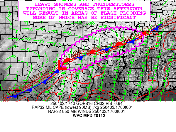
MESOSCALE PRECIPITATION DISCUSSION 0112
NWS WEATHER PREDICTION CENTER COLLEGE PARK MD
930 PM EDT SAT APR 21 2018
AREAS AFFECTED...SOUTHEAST TEXAS
CONCERNING...HEAVY RAINFALL...FLASH FLOODING POSSIBLE
VALID 220130Z - 220630Z
SUMMARY...POTENTIAL FOR TRAINING CELLS WITH RAIN RATES UP TO 2"/HR
AND POSSIBLE FLASH FLOODING
DISCUSSION...RECENT GOES-16 VISIBLE/3.9 SWIR/10.3 IR AND WSR-88D
RALA MOSAIC DEPICT INCREASED CONVECTION ACTIVATING ALONG COASTAL
BOUNDARY GENERALLY COLLOCATED WITH DEEP MOISTURE AXIS OF SSW TO
NNE WARM CONVEYOR BELT THAT EXTENDS FROM DEEP SOUTH TEXAS TO THE
ARKLATEX REGION. RADAR AND SURFACE OBSERVATIONS ALSO DENOTE A
WEAK SFC INFLECTION ALONG THE LINE MOVING INTO LAVACA COUNTY,TX.
NORTH AND EAST OF THIS INFLECTION...LOW LEVEL MOISTURE FLUX AND
CONVERGENCE WERE MAXIMIZED WITH ABOUT 1000 J/KG OF SBCAPES AIDING
DEVELOPMENT. ADDITIONALLY THE AREA IS ALSO FAVORABLE ALOFT WHERE
GOES-16 WV SUITE SHOW THE APEX OF THE ANTICYLONIC SUBTROPICAL JET
CLOUD STREAKS WITH 3-4H LOWER FLOW BACKING TOWARD THE NORTHEAST
PROVIDING A LOCALIZED MAXIMA OF DIVERGENCE TO FURTHER STRENGTHEN
UPDRAFTS.
SFC TDS UP TO 70F AND 10-15 KTS AND MODESTLY DEEP SATURATION
(1.75" TPW) IN THE PROFILES (PER CIRA LAYERED PW SUITE) IN THE
WARM CONVEYOR SUPPORT GOOD FLUX BUT ALSO EFFICIENT RAINFALL
PRODUCTION. THIS IS REFLECTED WELL WITH RECENT 01Z HRLY
OBSERVATION OF 1.99". LIMITING FACTORS ARE IN PLACE MAINLY
FOCUSED ON DRY/ABSORPTIVE SOILS CONDITIONS WITH 1HR FFG VALUES
OVER 3 AND 3HRLY OVER 4" MAKING FLASH FLOODING LIMITED TO VERY
ISOLATED AREAS OF MAXIMIZED TRAINING AND URBAN/HYDROPHOBIC
SURFACES. MEAN CELL MOTIONS WITHIN THE WARM SECTOR (SE OF THE
WARM CONVEYOR) ARE FLATTER RELATIVE TO THE INFLECTION POINT
SUGGESTING TRAINING IS POSSIBLE. RECENT HRRR SUGGESTS 3-4" ARE
POSSIBLE BUT OVER A SMALL DOMAIN. AS SUCH FLASH FLOODING IS
CONSIDERED POSSIBLE BUT ONLY BARELY ABOVE THRESHOLD...SUGGESTING
VERY LIMITED AREAL CONCERN OR DURATION.
GALLINA
ATTN...WFO...EWX...HGX...LCH...SHV...
ATTN...RFC...WGRFC...
Re: April 2018- Saturday Night Storms/Sunday Strong Front
Posted: Sat Apr 21, 2018 8:56 pm
by unome
http://www.spc.noaa.gov/products/outloo ... _0100.html
Day 1 Convective Outlook
NWS Storm Prediction Center Norman OK
0738 PM CDT Sat Apr 21 2018
Valid 220100Z - 221200Z
...THERE IS A MARGINAL RISK OF SEVERE THUNDERSTORMS ACROSS MUCH OF
EASTERN TEXAS INTO WESTERN LOUISIANA...
...SUMMARY...
Isolated severe thunderstorms are possible from eastern Texas into
western Louisiana through tonight.
...Eastern Texas into northern Louisiana...
A line of thunderstorms currently exists along a cold front over
north central TX, and will translate southeast through evening.
These storms will move coincident with an upper trough which will
provide favorable deep shear and cool temperatures aloft. At the
surface, 60s F dewpoints and weak southeasterly surface winds will
maintain favorable inflow into the existing storms, and some upscale
growth and/or additional isolated activity is possible producing
hail or wind. A brief/weak tornado cannot be ruled out over
southeastern TX, where low-level shear is maximized and dewpoints
are a bit higher.
..Jewell.. 04/22/2018
Re: April 2018- Saturday Night Storms/Sunday Strong Front
Posted: Sat Apr 21, 2018 9:12 pm
by jasons2k
Looks like a decent rain headed this way!
Re: April 2018- Saturday Night Storms/Sunday Strong Front
Posted: Sat Apr 21, 2018 9:23 pm
by davidiowx
Bring it on! Looking good for some nice steady rains over the next few hours. Some heavy rain mixed in as well! I’ll take it! No sprinklers tomorrow for you Jason

Re: April 2018- Saturday Night Storms/Sunday Strong Front
Posted: Sat Apr 21, 2018 10:28 pm
by Katdaddy
Special Weather Statement
National Weather Service Houston/Galveston TX
1020 PM CDT SAT APR 21 2018
TXZ213-226-227-237-220415-
Brazoria TX-Wharton TX-Harris TX-Fort Bend TX-
1020 PM CDT SAT APR 21 2018
...SPECIAL WEATHER STATEMENT...
At 1020 PM CDT, Doppler radar was tracking a strong thunderstorm near
East Bernard, or 12 miles west of Rosenberg, moving east at 30 mph.
Half inch hail and winds in excess of 30 mph will be possible with
this storm.
Locations impacted include...
Western Pearland, Sugar Land, Missouri City, Rosenberg, Stafford,
Richmond, western Manvel, First Colony, Fresno, Pecan Grove,
Needville, East Bernard, Arcola, Iowa Colony, Pleak, Fairchilds,
Beasley, Kendleton, Orchard and Bonney.
PRECAUTIONARY/PREPAREDNESS ACTIONS...
Frequent cloud to ground lightning is occurring with this storm.
Lightning can strike 10 miles away from a thunderstorm. Seek a safe
shelter inside a building or vehicle.
Re: April 2018- Saturday Night Storms/Sunday Strong Front
Posted: Sat Apr 21, 2018 11:14 pm
by Katdaddy
Special Weather Statement
National Weather Service Houston/Galveston TX
1042 PM CDT SAT APR 21 2018
TXZ226-227-237-220415-
Brazoria TX-Wharton TX-Fort Bend TX-
1042 PM CDT SAT APR 21 2018
...SIGNIFICANT WEATHER ADVISORY FOR EAST CENTRAL WHARTON...SOUTHERN
FORT BEND AND NORTHWESTERN BRAZORIA COUNTIES UNTIL 1115 PM CDT...
At 1042 PM CDT, Doppler radar was tracking strong thunderstorms along
a line extending from Rosenberg to near Pleak to near Boling-Iago.
Movement was east at 35 mph.
Half inch hail and winds in excess of 40 mph will be possible with
these storms.
Locations impacted include...
Sugar Land, western Missouri City, Rosenberg, Stafford, Richmond,
First Colony, Pecan Grove, Needville, Pleak, Fairchilds, Beasley,
Thompsons, Greatwood, New Territory, Cumings, Fifth Street and
northwestern Sienna Plantation.
Re: April 2018- Saturday Night Storms/Sunday Strong Front
Posted: Sat Apr 21, 2018 11:34 pm
by Katdaddy
Special Weather Statement
National Weather Service Houston/Galveston TX
1117 PM CDT SAT APR 21 2018
TXZ213-214-227-237-238-220515-
Brazoria TX-Chambers TX-Galveston TX-Harris TX-Fort Bend TX-
1117 PM CDT SAT APR 21 2018
...SPECIAL WEATHER STATEMENT...
At 1117 PM CDT, Doppler radar was tracking strong thunderstorms along
a line extending from Pearland to 6 miles south of Brazos Bend State
Park. Movement was east at 45 mph.
Winds in excess of 30 mph will be possible with these storms.
Locations impacted include...
Southern Pasadena, Pearland, League City, Galveston Causeway,
Galveston Island West End, Texas City, Friendswood, Alvin, northern
Angleton, Dickinson, La Marque, Santa Fe, Seabrook, Webster,
Hitchcock, Manvel, Kemah, Galveston Pier 21, Clear Lake and Fresno.
PRECAUTIONARY/PREPAREDNESS ACTIONS...
Torrential rainfall is also occurring with these storms, and may lead
to localized flooding. Do not drive your vehicle through flooded
roadways.
Frequent cloud to ground lightning is occurring with these storms.
Lightning can strike 10 miles away from a thunderstorm. Seek a safe
shelter inside a building or vehicle.
Re: April 2018- Saturday Night Storms/Sunday Strong Front
Posted: Sun Apr 22, 2018 12:31 am
by DoctorMu
Looks like the Canadian was right after all. We reached up a little under an inch of rain. Good soaking stuff. I'd take this week's weather all year long. No question about it. Sprinklers and A/C OFF, just where I like them!

Re: April 2018- Saturday Night Storms/Sunday Strong Front
Posted: Sun Apr 22, 2018 9:02 am
by srainhoutx
Just emptied 1.33 inches from the rain gage. If we keep this up, no drought worries for our part of the State for a while...
Re: April 2018- 2 Fronts This Week/Mostly Pleasant WX Ahead
Posted: Sun Apr 22, 2018 9:44 am
by Cromagnum
Managed 2.5 inches south of town, so thankfully can keep the sprinklers locked up.
Re: April 2018- 2 Fronts This Week/Mostly Pleasant WX Ahead
Posted: Sun Apr 22, 2018 10:18 am
by mckinne63
Not sure how much rain we received in Stafford, but the pool is full. Loving these temps!
Re: April 2018- 2 Fronts This Week/Mostly Pleasant WX Ahead
Posted: Sun Apr 22, 2018 10:40 am
by Cromagnum
mckinne63 wrote:Not sure how much rain we received in Stafford, but the pool is full. Loving these temps!
That's the truth. Gonna go ride my bike in a bit.