
October 2015 - Severe Storms/Moderate Risk Excessive Rainfal
-
DoctorMu

- Posts: 7624
- Joined: Sun Jun 28, 2015 11:58 am
- Location: College Station
- Contact:
GFS has moved the target considerably East with expected Patricia remnants impacting.Andrew wrote:Large D3 Moderate Excessive Rainfall for E and S Texas.
-
srainhoutx

- Site Admin

- Posts: 19699
- Joined: Tue Feb 02, 2010 2:32 pm
- Location: Maggie Valley, NC
- Contact:
The 12Z Euro is in agreement with the GFS suggesting a Coastal low tracking up the Coast from near Brownsville dropping a lot of heavy rain from Corpus to Houston and on East toward Beaumont. Jeff sent out an Update for Coastal Flooding issues that seems to be increasing. Will update further this afternoon.
From Jeff:
High tide coastal flooding occurring late this morning.
Increase in winds overnight and early this morning has forced more water against the coast with the morning high tide having produced coastal flooding in portions of Harris County and on the Bolivar Peninsula. Expect tidal conditions to remain similar Friday and Saturday with an increase on Sunday.
Now intense (category 4) hurricane Patricia is expected to strike the Mexican west coast and turn NNE to NE with upper level energy moving into TX Sunday. Forecast models are attempting to deepen a surface low along the TX coast in response to the strong upper level energy from Patricia on Sunday. This will only serve to enhance already high rainfall totals and increase coastal winds.
Concern is growing that coastal tides will increase another 1.0-1.5 ft on Sunday which will place us into flood warning levels at many locations along the coast…including Bolivar, west end of Galveston Island, Clear Lake/Kemah/Seabrook. There is still a lot of uncertainty on how this will play out, but persons should be aware of the potential for coastal flooding and impassable roadways near the coast this weekend.
- Attachments
-
-
Carla/Alicia/Jerry(In The Eye)/Michelle/Charley/Ivan/Dennis/Katrina/Rita/Wilma/Humberto/Ike/Harvey
Member: National Weather Association
Facebook.com/Weather Infinity
Twitter @WeatherInfinity
Member: National Weather Association
Facebook.com/Weather Infinity
Twitter @WeatherInfinity
-
srainhoutx
- Site Admin
- Posts: 19699
- Joined: Tue Feb 02, 2010 2:32 pm
- Location: Maggie Valley, NC
- Contact:
Update from Nesdis:
LOCATION...TEXAS...OKLAHOMA...
.
ATTN WFOS...FWD...OUN...EWX...SJT...
ATTN RFCS...LMRFC...ABRFC...WGRFC...
.
EVENT...UPDATE TO EARLIER SPE FOR HEAVY RAIN THREAT
.
SATELLITE ANALYSIS AND TRENDS...LATEST WV IMAGERY WAS SHOWING LIFTING AREA
OF HEIGHT FALLS TOWARDS PORTIONS OF E CO IN RESPONSE TO HEIGHT FALLS NOW
AMPLIFYING SE TOWARDS THE GREAT BASIN REGION. WITHIN THE LARGER TROF,
IMPULSE OVER PORTIONS OF NE NM WAS BEGINNING TO LIFT NE OUT OF THE BASE
OF THE TROF WITH PRONOUNCED STRATOSPHERIC EXTRUSION WITHIN UPPER LEVEL
FRONTAL ZONE OVER PORTIONS OF E NM SUGGESTED BY LATEST GOES RGB PRODUCTS.
UPPER JET STREAK WITHIN THIS FRONTAL ZONE WITH DRY SLOT EXTENDING FROM E
CO/W KS S TO W CENTRL TX AND E NM. IN SUBTROPICAL STREAM WITH UPSTREAM
TAP TO PATRICIA, JET STREAK BEING ENHANCED BY RAPIDLY STRENGTHENING
PATRICIA WAS LIFTING NE THROUGH N MEXICO AND TOWARDS S CENTRAL TX.
AT THE SURFACE, OUTFLOW/EFFECTIVE FRONTAL BOUNDARY FROM MORNING MCS
EXTENDED FROM PORTIONS OF N CNTRL OK IN THE VIC OF SWO EXTENDING S TO
N CENTRAL TX IN THE VIC OF GLE AND THEN ARCING S TO N OF 6R6. THIS HAS
LIMITED DESTABILIZATION OVER MUCH OF W OK AND N CENTRAL TX WITH BREAKS
IN THE LOW LEVEL CLOUD FIELD COMBINED WITH STEEPER MID LEVEL LAPSE
RATES ON GOES SOUNDER IMAGERY OVER PORTIONS OF CENTRAL TX ALLOWING FOR
MODERATE DESTABILIZATION OVER CENTRAL AND S CENTRAL TX. INTERPOLATED
GOES SOUNDER IMAGERY WAS INDICATING INHIBITION REMAINS WITH PREFRONTAL
ENVIRONMENT BUT HAVE BEGUN TO SEE SOME EROSION OF THIS BACK TOWARDS
THE VIC OF SJT. WOULD EXPECT A CONTINUED REDUCTION OF INHIBITION AND
EITHER STRENGTHENING OR REDEVELOPING CONVECTION THROUGHOUT THE AFTERNOON
INTO EVENING ALONG EFFECTIVE FRONTAL BOUNDARY AS FORCING FROM LIFTING
SHORTWAVE TROF OVER NM SKIMS THE AREA AND IS ENHANCED BY DEVELOPING
COUPLED JET PATTERN AS JET OVER N MEXICO LIFTS NE. MOISTURE WAS RATHER
ANOMALOUS ON LATEST BLENDED PW ANALYSIS WITH PW ANOMALIES AROUND 200%
ABOVE NORMAL CLIMATOLOGICAL VALUES BUT PERSISTENT CONVECTIVE COMPLEX HAS
INHIBITED DEEPER MOISTURE TRANSPORT TO SOME EXTENT TO THE NW. INFLOW FROM
INSTABILITY SOURCE REGION TOWARDS FAVORABLE DIFFLUENT FLOW PATTERN TO THE
SE OF HEIGHT FALLS CENTERED OVER PORTINOS OF N CENTRAL TX, COMBINED WITH
UNIDIRECTIONAL PROFILES WOULD SUGGEST THAT ENVIRONMENT SHOULD BE FAVORABLE
FOR TRAINING AND BACKWARD PROPAGATING/BACKBUILIDING CONVECTIVE COMPONENTS.
LARGE SCALE PATTERN DID APPEAR SIMILAR TO MADDOX SYNOPTIC TYPE EVENTS.
PLEASE SEE STATEMENTS FROM SPC FOR SEVERE WEATHER THREAT AND UPCOMING
FFGMPD FOR DETAILED MODEL ANALYSIS AND FORECAST RAINFALL AMOUNTS.
Carla/Alicia/Jerry(In The Eye)/Michelle/Charley/Ivan/Dennis/Katrina/Rita/Wilma/Humberto/Ike/Harvey
Member: National Weather Association
Facebook.com/Weather Infinity
Twitter @WeatherInfinity
Member: National Weather Association
Facebook.com/Weather Infinity
Twitter @WeatherInfinity
-
ticka1
- Posts: 1265
- Joined: Wed Feb 03, 2010 3:02 pm
- Location: Baytown/Mont Belvieu
- Contact:
When will all this rain start affecting us here in SE Texas? Friday or will it wait until Saturday?
-
Andrew
- Site Admin
- Posts: 3506
- Joined: Wed Feb 03, 2010 9:46 pm
- Location: North-West Houston
- Contact:
ticka1 wrote:When will all this rain start affecting us here in SE Texas? Friday or will it wait until Saturday?
Current thinking is Friday night into Saturday morning is when it should begin to start. Then Saturday evening is when the heavier stuff should arrive
For Your Infinite Source For All Things Weather Visit Our Facebook
-
srainhoutx
- Site Admin
- Posts: 19699
- Joined: Tue Feb 02, 2010 2:32 pm
- Location: Maggie Valley, NC
- Contact:
5 Day QPF graphics are out. HGX going with 3 to 5 inches across the area with some 5 to 10 inch totals not out of the question. They particularly are interested in the Coastal low and just how strong and well developed it becomes. There is a chance that their rainfall totals could be a bit on the low side, and this a remains a very complicated and somewhat low confidence forecast because of the unknowns as of this afternoon. It is appearing the Patricia is well on the way to becoming a very dangerous Category 5 Hurricane as it makes landfall. Going to edit the Topic Title to reflect the better chances of a Heavy Rainfall Event since Flash Flood Watches likely will be issued tomorrow morning for much of SE Texas and our neighbors to the East.
- Attachments
-
Carla/Alicia/Jerry(In The Eye)/Michelle/Charley/Ivan/Dennis/Katrina/Rita/Wilma/Humberto/Ike/Harvey
Member: National Weather Association
Facebook.com/Weather Infinity
Twitter @WeatherInfinity
Member: National Weather Association
Facebook.com/Weather Infinity
Twitter @WeatherInfinity
-
stormlover
- Posts: 439
- Joined: Wed Dec 04, 2013 10:21 am
- Location: Lumberton TX
- Contact:
I think we could see the amount go higher, weird feeling about this
-
unome
- Posts: 3062
- Joined: Fri Feb 12, 2010 6:11 pm
latest full HGX Area Forecast Discussion here: http://forecast.weather.gov/product.php ... roduct=AFD
a piece of it:
still expecting to see periods of on-again off-again showers and possible thunderstorms through friday night. heaviest rains are expected to remain off to our north through west...roughly from the red river area south and southwest into the hill country and possibly toward the middle texas coast (corpus christi area). it is looking like our area`s threat for heavy rainfall increases from west to east during the day on saturday...but our best chance comes saturday night through much of sunday as the remnants of hurricane patricia interact with a developing surface low just off the texas coast. this potentially strong coastal storm system will have very abundant moisture levels along with a lot of lift and instability to work with to produce lots of rain. where the system forms...how strong it gets...and where it goes will be a big player as to what parts of our area receive the highest rainfall amounts. with this forecast package...the potential is there for widespread rainfall totals of 2 to 5 inches along with isolated totals of 5 to 10 inches. flash flood watches are possible. rains lingering on into monday and tuesday have the potential to cause flooding problems if occurring on already saturated grounds
-
unome
- Posts: 3062
- Joined: Fri Feb 12, 2010 6:11 pm
some great WU blogs on Patricia and rains affecting Texas:
Major Threat to Mexico from Category 4 Patricia
By: Bob Henson , 8:07 PM GMT on October 22, 2015
http://www.wunderground.com/blog/JeffMa ... rynum=3163
Conditions are aligning for a predecessor rain event (PRE) across the heart of Texas as Patricia approaches this weekend. In such events, tropical moisture well out ahead of a landfalling tropical cyclone interacts with a surface front and upper-level trough to produce heavy rainfall, often with significant inland flooding. By Saturday and Sunday, Patricia’s remnants will be moving across southern Texas, exacerbating rainfall there. Multi-day totals for the whole event will depend on where each of the various elements ends up being focused, but central Texas from Dallas to Austin appears to be most at risk for totals that could locally exceed a foot. It’s been a year of rainfall extremity for Texas: May was by far the wettest month in state history, quenching severe drought conditions, while dryness in late summer and early fall put much of the state back into drought
Heavy Rain in Texas as Progressive Pattern Leads to Increased Forecast Uncertainty
By: Steve Gregory , 8:50 PM GMT on October 22, 2015
http://www.wunderground.com/blog/SteveG ... trynum=394
Between the approaching high level TROF and a surge of deep, tropical moisture laden air associated with Hurricane PATRICIA now approaching the southwest Mexican coast, there is a (continued) growing threat of extreme rainfall and flash flooding in portions of Texas as we move through the weekend. The TROF and developing tropical flow will first bring a period of heavy rain to central and western TX - with the remnants of Hurricane PATRICIA then expected to bring a second and stronger rain event to central and east TX during the weekend. In total, widespread 2-4 inches of rain – with localized 5-Day totals over 10” - appears likely. These rain producing systems will then advance northeastward towards the Great Lakes region and East/Northeast US next week. The exact path of the heaviest rainfall is fairly uncertain due to the broader scale uncertainties that continue to plague the modeling programs.
-
Texaspirate11

- Posts: 1278
- Joined: Tue Dec 31, 2013 12:24 am
- Contact:
David Paul says Sunday will be the heaviest rain day....
Just because you're disabled, you don't have to be a victim
Be Weather Aware & Prepared!
Barbara Jordan Winner in Media
Disability Integration Consultant
Be Weather Aware & Prepared!
Barbara Jordan Winner in Media
Disability Integration Consultant
-
srainhoutx
- Site Admin
- Posts: 19699
- Joined: Tue Feb 02, 2010 2:32 pm
- Location: Maggie Valley, NC
- Contact:
Afternoon briefing from Jeff:
High tides and coastal flooding increasingly likely Sunday-Monday
Heavy rainfall and possible flooding Saturday-Monday
Strong coastal storm possible Sunday-Monday
Discussion:
Ingredients coming together to produce adverse and moderate to high impact weather event across much of Texas Friday-Monday. Big change today has been the explosive development of Hurricane Patricia off the Mexican west coast growing from a TS to a category 4 hurricane in the last 24 hours. Data from USAF mission this afternoon indicates a very powerful hurricane has evolved today and will landfall on the Mexican coast late Friday and then track across MX and into TX Sunday. Given the extremely intense core of this hurricane, it is likely that a better defined upper level core structure will survive the mountains of MX and reach SW TX early Sunday. This feature will likely help to induce surface low pressure along the middle TX coast which then deepens Sunday into Monday. This is certainly concerning for coastal tidal impacts and now potential for gale force winds across the NW Gulf and coastal counties along with sustained heavy rainfall.
Will not go into much additional detail than that as there is still some uncertainty on exactly how intense the remains of Patricia will be when they arrive into TX and how this helps to develop and interact with the coastal low, but as seen below (there is not much spread in the model tracks).
Impacts:
Heavy Rainfall:
Heavy rainfall is already ongoing over NW TX and this band will slowly move SE on Friday into C TX and then SE TX on Saturday (afternoon). Moisture profiles are near record levels by Saturday over S TX as mid and high level moisture from Patricia pours NE into the region and low level Gulf inflow is maintained. PWS progged to rise to 2.3-2.6 inches over the region which is easily +2SD above late October normals. Models are certainly showing some excessive rainfall pockets, but are not consistent on where these pockets will be. General experience is that we will not know where the most significant rainfall will happen until it is underway and usually this is a function of training bands. See no reason at the moment to change the previous rainfall forecast.
4-6 inches W of I-45
2-4 inches E of I-45
Isolated locations will likely see 6-8 inches and even 10 inches or greater cannot be ruled out especially from Matagorda Bay northward to near College Station.
While grounds are dry this rainfall magnitude will certainly cause run-off and significant rises on area watersheds. Additionally, nearly saturated air column will support high hourly rainfall rates leading to potential urban flooding.
Tides:
Getting increasingly worried on the tides and threat of more significant coastal flooding Sunday-Monday. Utilization of ET-storm surge model run of the GFS forecast model shows storm surge values of 1.0-1.5 ft by Sunday along the upper TX coast as a function of increasing E to ESE winds over the NW Gulf on the eastern flank of the developing surface reflection. This storm surge is a function of sustained ENE winds over the last several days which is trapping high tides on the coast and additional increasing wave action due to stronger winds (near or over gale force) by Sunday. Total water level rises on the coast of 4.0-5.0 ft are now possible which is at or above our coastal flood warning criteria.
Water levels of this magnitude would likely result in overwash and flooding on Bolivar, the west end of Galveston Island, portions of Surfside and Freeport, portions of Seabrook/Kemah/Shoreacres/Baytown/Nassau Bay. Some locations could become cut-off during high tides and some coastal roads may be inundated for a long period of time. Toward Matagorda Bay tides of 4.0-4.5 ft will be possible along the west side of the Bay from Port Lavaca southward to Port O Connor and this would likely cause some minor coastal flooding. Critical levels where more widespread coastal flooding and impacts begin range from 4.0-5.0 ft at various locations along the upper TX coast and in the inland bays. Even with values around 3.5-3.7ft this morning there were impacts on Bolivar and at Nassau Bay.
Will need to monitor this aspect very closely over the next 24-48 hours as any additional increase would only result in greater impacts.
Winds:
ESE winds today have really increased into the 20-30mph range and expect slightly lower speeds on Friday. Developing surface low on Sunday will really ramp up wind speeds possibly into high end Small Craft Advisory levels or Gale Warning levels. Could see a large area of sustained 30-45mph winds Sunday into Monday over the Gulf waters and inland bays. Still too early to be certain, but will watch this aspect.
Highlights:
· Prolonged heavy rainfall event from Saturday afternoon in Monday
· Elevated coastal tides Friday-Saturday (minor impacts)
· Near or above warning criteria tides Sunday/Monday (impacts becoming more likely)
· Winds increasing Sunday to 30-45mph coast to 25-35mph inland
· Seas building 8-10ft over the weekend over the Gulf waters
Impacts:
· Urban flooding (street) possible Saturday-Monday
· Rises on area bayous/creeks likely
· River rises (possibly to bankfull) next week
· Coastal flooding impact to roads, low lying areas, docks, some homes Sunday/Monday especially at high tide
· High wave action will likely result in beach and dune erosion
· Hazardous marine conditions Sunday-Monday…small craft may need to remain in port
· Dangerous rip currents…Galveston Beach Patrol reports strong rip currents and these will continue due to building wave action.
·
Total Water Level Forecast for Galveston through Sunday (Black line):
Carla/Alicia/Jerry(In The Eye)/Michelle/Charley/Ivan/Dennis/Katrina/Rita/Wilma/Humberto/Ike/Harvey
Member: National Weather Association
Facebook.com/Weather Infinity
Twitter @WeatherInfinity
Member: National Weather Association
Facebook.com/Weather Infinity
Twitter @WeatherInfinity
-
Texaspirate11
- Posts: 1278
- Joined: Tue Dec 31, 2013 12:24 am
- Contact:
City of Galveston Press release
FOR IMMEDIATE RELEASE
Galveston Could Experience Severe Weather and Flooding
Four and One-half Foot Elevated Tides Possible Over the Weekend
GALVESTON, TX (October 22, 2015) – The National Weather Service (NWS) has issued a Coastal Flood Advisory for areas along the Gulf Coast this weekend to include Galveston Island. A tidal rise of over four feet is possible during this time, increasing the likelihood that roadways will become impassable. Heavy rains are also expected and will exacerbate drainage issues. Residents are cautioned to not drive through standing water and remember: Turn around, don’t drown! Stay tuned to local weather stations, websites, and news outlets for further information over the weekend.
XXXX
Just because you're disabled, you don't have to be a victim
Be Weather Aware & Prepared!
Barbara Jordan Winner in Media
Disability Integration Consultant
Be Weather Aware & Prepared!
Barbara Jordan Winner in Media
Disability Integration Consultant
-
sambucol

- Posts: 1215
- Joined: Wed Feb 03, 2010 5:43 pm
- Location: Mont Belvieu
- Contact:
Are the remnants of Patricia going to get over water once it crosses Mexico? Could it reorganize into a depression or tropical storm once it crosses over Mexico?
-
unome
- Posts: 3062
- Joined: Fri Feb 12, 2010 6:11 pm
latest 72-hr Marine Surface Forecast from NHC's site: http://www.nhc.noaa.gov/marine/
About their Surface Forecasts: http://www.nhc.noaa.gov/abouttafbprod.s ... RFACEFCSTS
the larger X in the gulf is the estimated 96-hr forecast position
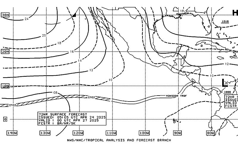

About their Surface Forecasts: http://www.nhc.noaa.gov/abouttafbprod.s ... RFACEFCSTS
the larger X in the gulf is the estimated 96-hr forecast position
Last edited by unome on Thu Oct 22, 2015 7:14 pm, edited 1 time in total.
-
Paul Robison
srainhoutx wrote:Afternoon briefing from Jeff:
High tides and coastal flooding increasingly likely Sunday-Monday
Heavy rainfall and possible flooding Saturday-Monday
Strong coastal storm possible Sunday-Monday
Discussion:
Ingredients coming together to produce adverse and moderate to high impact weather event across much of Texas Friday-Monday. Big change today has been the explosive development of Hurricane Patricia off the Mexican west coast growing from a TS to a category 4 hurricane in the last 24 hours. Data from USAF mission this afternoon indicates a very powerful hurricane has evolved today and will landfall on the Mexican coast late Friday and then track across MX and into TX Sunday. Given the extremely intense core of this hurricane, it is likely that a better defined upper level core structure will survive the mountains of MX and reach SW TX early Sunday. This feature will likely help to induce surface low pressure along the middle TX coast which then deepens Sunday into Monday. This is certainly concerning for coastal tidal impacts and now potential for gale force winds across the NW Gulf and coastal counties along with sustained heavy rainfall.
Will not go into much additional detail than that as there is still some uncertainty on exactly how intense the remains of Patricia will be when they arrive into TX and how this helps to develop and interact with the coastal low, but as seen below (there is not much spread in the model tracks).
Impacts:
Heavy Rainfall:
Heavy rainfall is already ongoing over NW TX and this band will slowly move SE on Friday into C TX and then SE TX on Saturday (afternoon). Moisture profiles are near record levels by Saturday over S TX as mid and high level moisture from Patricia pours NE into the region and low level Gulf inflow is maintained. PWS progged to rise to 2.3-2.6 inches over the region which is easily +2SD above late October normals. Models are certainly showing some excessive rainfall pockets, but are not consistent on where these pockets will be. General experience is that we will not know where the most significant rainfall will happen until it is underway and usually this is a function of training bands. See no reason at the moment to change the previous rainfall forecast.
4-6 inches W of I-45
2-4 inches E of I-45
Isolated locations will likely see 6-8 inches and even 10 inches or greater cannot be ruled out especially from Matagorda Bay northward to near College Station.
While grounds are dry this rainfall magnitude will certainly cause run-off and significant rises on area watersheds. Additionally, nearly saturated air column will support high hourly rainfall rates leading to potential urban flooding.
Tides:
Getting increasingly worried on the tides and threat of more significant coastal flooding Sunday-Monday. Utilization of ET-storm surge model run of the GFS forecast model shows storm surge values of 1.0-1.5 ft by Sunday along the upper TX coast as a function of increasing E to ESE winds over the NW Gulf on the eastern flank of the developing surface reflection. This storm surge is a function of sustained ENE winds over the last several days which is trapping high tides on the coast and additional increasing wave action due to stronger winds (near or over gale force) by Sunday. Total water level rises on the coast of 4.0-5.0 ft are now possible which is at or above our coastal flood warning criteria.
Water levels of this magnitude would likely result in overwash and flooding on Bolivar, the west end of Galveston Island, portions of Surfside and Freeport, portions of Seabrook/Kemah/Shoreacres/Baytown/Nassau Bay. Some locations could become cut-off during high tides and some coastal roads may be inundated for a long period of time. Toward Matagorda Bay tides of 4.0-4.5 ft will be possible along the west side of the Bay from Port Lavaca southward to Port O Connor and this would likely cause some minor coastal flooding. Critical levels where more widespread coastal flooding and impacts begin range from 4.0-5.0 ft at various locations along the upper TX coast and in the inland bays. Even with values around 3.5-3.7ft this morning there were impacts on Bolivar and at Nassau Bay.
Will need to monitor this aspect very closely over the next 24-48 hours as any additional increase would only result in greater impacts.
Winds:
ESE winds today have really increased into the 20-30mph range and expect slightly lower speeds on Friday. Developing surface low on Sunday will really ramp up wind speeds possibly into high end Small Craft Advisory levels or Gale Warning levels. Could see a large area of sustained 30-45mph winds Sunday into Monday over the Gulf waters and inland bays. Still too early to be certain, but will watch this aspect.
Highlights:
· Prolonged heavy rainfall event from Saturday afternoon in Monday
· Elevated coastal tides Friday-Saturday (minor impacts)
· Near or above warning criteria tides Sunday/Monday (impacts becoming more likely)
· Winds increasing Sunday to 30-45mph coast to 25-35mph inland
· Seas building 8-10ft over the weekend over the Gulf waters
Impacts:
· Urban flooding (street) possible Saturday-Monday
· Rises on area bayous/creeks likely
· River rises (possibly to bankfull) next week
· Coastal flooding impact to roads, low lying areas, docks, some homes Sunday/Monday especially at high tide
· High wave action will likely result in beach and dune erosion
· Hazardous marine conditions Sunday-Monday…small craft may need to remain in port
· Dangerous rip currents…Galveston Beach Patrol reports strong rip currents and these will continue due to building wave action.
·
Total Water Level Forecast for Galveston through Sunday (Black line):
Dear Jeff:
Is there anything to what SPC says?
...SUMMARY...
ORGANIZED SEVERE THUNDERSTORMS ARE NOT EXPECTED ON SATURDAY ACROSS
THE CONTIGUOUS UNITED STATES.
...SYNOPSIS...
BROAD CYCLONIC MID-LEVEL FLOW WILL EXTEND FROM THE CANADIAN ROCKIES
THROUGH THE UPPER MIDWEST/GREAT LAKES AND INTO ERN CANADA WHILE A
LOWER-LATITUDE TROUGH SLOWLY MOVES EWD OVER THE SRN PLAINS. A COLD
FRONT WILL MOVE EWD ACROSS THE OH VALLEY AND THE SWRN EXTENSION OF
THE FRONTAL ZONE WILL RESIDE OVER THE ARKLATEX AND INTO ERN-SRN
PORTIONS OF TX. MOISTURE RICH...SELY LOW-LEVEL FLOW OVER THE WRN
GULF BASIN COUPLED WITH FRONTAL LIFT WILL SUPPORT THE DEVELOPMENT OF
SCATTERED SHOWERS/THUNDERSTORMS FROM THE LOWER OH VALLEY SWWD INTO
TX. A DIMINISHING RESERVOIR OF BUOYANCY/SHEAR COMPARED TO PRIOR
DAYS WILL TEND TO LIMIT STORM STRENGTH AND PRECLUDE THE NEED FOR
LOW-SEVERE PROBABILITIES.
-
Paul Robison
Texaspirate11 wrote:David Paul says Sunday will be the heaviest rain day....
Oh, no!
-
Cromagnum
- Posts: 3021
- Joined: Thu Feb 03, 2011 10:42 pm
- Location: Georgetown
- Contact:
Category 5 based on Dvorak intensity and only continuing to strengthen.
-
Paul Robison
What does that mean for us?Cromagnum wrote:Category 5 based on Dvorak intensity and only continuing to strengthen.
-
Cromagnum
- Posts: 3021
- Joined: Thu Feb 03, 2011 10:42 pm
- Location: Georgetown
- Contact:
The mountains in Mexico should shred it up all the same, but I imagine stronger in still = stronger out.