
I love your enthusiasm BB.biggerbyte wrote:Landfall will be somewhere from S. E. Texas, to Central LA. You can take that to the bank. Certainly no further east than NOLA, but I think this will push a bit further south than some may think at this point, so NOLA would seem less likely.
We'll see..
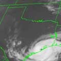
TD 5 Gulf Of Mexico
-
desiredwxgd
- Posts: 125
- Joined: Wed Feb 03, 2010 6:30 pm
- Location: TX/LA/Southern New England
- Contact:
JMS
SR. ENSC.
SR. ENSC.
-
Snowman
- Posts: 191
- Joined: Sun Jun 27, 2010 11:25 pm
- Location: Mountain View, CA
- Contact:
at this point there seems to be a lot of rain on the west side of the low so who knows maybe we will get some rain even if the system makes landfall east of us.
any thoughts?
any thoughts?
-
Ptarmigan

- Statistical Specialist

- Posts: 4431
- Joined: Wed Feb 03, 2010 7:20 pm
- Contact:
Should bear watching. I noticed summers without 100°F and wet July's saw major hurricanes make landfall from Great Galveston Hurricane of 1900 to Alicia.
-
desiredwxgd
- Posts: 125
- Joined: Wed Feb 03, 2010 6:30 pm
- Location: TX/LA/Southern New England
- Contact:
Th QPF would suggest some rain.Snowman wrote:at this point there seems to be a lot of rain on the west side of the low so who knows maybe we will get some rain even if the system makes landfall east of us.
any thoughts?
JMS
SR. ENSC.
SR. ENSC.
-
Rip76

- Posts: 2083
- Joined: Mon Feb 15, 2010 12:38 am
- Location: The Woodlands
- Contact:
I notice they've moved us out of the purple.... to about 1 inch..
-
srainhoutx

- Site Admin

- Posts: 19699
- Joined: Tue Feb 02, 2010 2:32 pm
- Location: Maggie Valley, NC
- Contact:
Carla/Alicia/Jerry(In The Eye)/Michelle/Charley/Ivan/Dennis/Katrina/Rita/Wilma/Humberto/Ike/Harvey
Member: National Weather Association
Facebook.com/Weather Infinity
Twitter @WeatherInfinity
Member: National Weather Association
Facebook.com/Weather Infinity
Twitter @WeatherInfinity
-
desiredwxgd
- Posts: 125
- Joined: Wed Feb 03, 2010 6:30 pm
- Location: TX/LA/Southern New England
- Contact:
Rip76 wrote:I notice they've moved us out of the purple.... to about 1 inch..
Keep in mind thats on a 5-day "scale".
JMS
SR. ENSC.
SR. ENSC.
-
biggerbyte
- Posts: 1420
- Joined: Thu Feb 04, 2010 12:15 am
- Location: Porter, Texas. (Montgomery County)
- Contact:
desiredwxgd wrote:I love your enthusiasm BB.biggerbyte wrote:Landfall will be somewhere from S. E. Texas, to Central LA. You can take that to the bank. Certainly no further east than NOLA, but I think this will push a bit further south than some may think at this point, so NOLA would seem less likely.
We'll see..
Again, nothing is for certain just yet.
-
srainhoutx
- Site Admin
- Posts: 19699
- Joined: Tue Feb 02, 2010 2:32 pm
- Location: Maggie Valley, NC
- Contact:
HPC:
MEANWHILE...CONFIDENCE REMAINS LOW WITH OUR DEPICTION OF THE
REMAINS OF TD FIVE FORECAST NEAR THE GULF COAST DURING THE SHORT
RANGE BEFORE WEAKENING OVER THE LOWER MS VALLEY DURING THE FIRST
HALF OF THE MEDIUM RANGE. THIS REMAINS OUR COMPROMISE TRACK AFTER
COORDINATION WITH TPC. THIS SYSTEM HAS POTENTIAL TO FOCUS SOME
HEAVY DOWNPOURS LOCALLY. HOWEVER...THIS COMPROMISE GUIDANCE TRACK
REMAINS AT ODDS WITH THE 00 UTC GFS THAT BRINGS THE SYSTEM MUCH
FARTHER NEWD...RECENT ECMWF AND DGEX RUNS THAT ARE MUCH FARTHER
SWWD INTO TX...AND LATEST 06/12 UTC GFS RUNS THAT HAVE TRENDED WWD
FROM ITS RESPECTIVE 00 UTC GFS RUN.
Carla/Alicia/Jerry(In The Eye)/Michelle/Charley/Ivan/Dennis/Katrina/Rita/Wilma/Humberto/Ike/Harvey
Member: National Weather Association
Facebook.com/Weather Infinity
Twitter @WeatherInfinity
Member: National Weather Association
Facebook.com/Weather Infinity
Twitter @WeatherInfinity
-
desiredwxgd
- Posts: 125
- Joined: Wed Feb 03, 2010 6:30 pm
- Location: TX/LA/Southern New England
- Contact:
You can defiantly (in my opinion) make out the “L” itself and the cyclonic flow. Nice convective activity to its southwest.
JMS
SR. ENSC.
SR. ENSC.
-
desiredwxgd
- Posts: 125
- Joined: Wed Feb 03, 2010 6:30 pm
- Location: TX/LA/Southern New England
- Contact:
How does one a link or rather radar in motion type link?
JMS
SR. ENSC.
SR. ENSC.
-
srainhoutx
- Site Admin
- Posts: 19699
- Joined: Tue Feb 02, 2010 2:32 pm
- Location: Maggie Valley, NC
- Contact:
desiredwxgd wrote:How does one a link or rather radar in motion type link?
Hope it helps...
http://forums.khou.com/faq.php#f2r7
Carla/Alicia/Jerry(In The Eye)/Michelle/Charley/Ivan/Dennis/Katrina/Rita/Wilma/Humberto/Ike/Harvey
Member: National Weather Association
Facebook.com/Weather Infinity
Twitter @WeatherInfinity
Member: National Weather Association
Facebook.com/Weather Infinity
Twitter @WeatherInfinity
-
srainhoutx
- Site Admin
- Posts: 19699
- Joined: Tue Feb 02, 2010 2:32 pm
- Location: Maggie Valley, NC
- Contact:
18Z NAM @ hour 42...

Carla/Alicia/Jerry(In The Eye)/Michelle/Charley/Ivan/Dennis/Katrina/Rita/Wilma/Humberto/Ike/Harvey
Member: National Weather Association
Facebook.com/Weather Infinity
Twitter @WeatherInfinity
Member: National Weather Association
Facebook.com/Weather Infinity
Twitter @WeatherInfinity
-
Rip76
- Posts: 2083
- Joined: Mon Feb 15, 2010 12:38 am
- Location: The Woodlands
- Contact:
That convection really looks like it wants to break off on it's own.
-
srainhoutx
- Site Admin
- Posts: 19699
- Joined: Tue Feb 02, 2010 2:32 pm
- Location: Maggie Valley, NC
- Contact:
18Z NAM @ 60 hours...

Carla/Alicia/Jerry(In The Eye)/Michelle/Charley/Ivan/Dennis/Katrina/Rita/Wilma/Humberto/Ike/Harvey
Member: National Weather Association
Facebook.com/Weather Infinity
Twitter @WeatherInfinity
Member: National Weather Association
Facebook.com/Weather Infinity
Twitter @WeatherInfinity
-
desiredwxgd
- Posts: 125
- Joined: Wed Feb 03, 2010 6:30 pm
- Location: TX/LA/Southern New England
- Contact:
Starting to see a decent amount of convection to the north wrapping around to the south-southeast.
JMS
SR. ENSC.
SR. ENSC.
-
TexasMetBlake
- Pro Met

- Posts: 839
- Joined: Wed Feb 03, 2010 7:03 pm
- Location: Spring/Woodlands
- Contact:
There is certainly an LLC or appears to be. Seems convection is on the uptick as well as banding features per Pensacola Radar trends. It's exciting/unnerving that models have trended south and west. IF** this gets far enough out, it will miss Louisiana and could pull an Alicia. Warning time here in Houston will be minimal so spread the word.
At this time, EVEN IF it missed Louisiana, I don't think we're looking at a major hurricane because the proximity to land. However, nothing can be ruled out at this time.
At this time, EVEN IF it missed Louisiana, I don't think we're looking at a major hurricane because the proximity to land. However, nothing can be ruled out at this time.
-
srainhoutx
- Site Admin
- Posts: 19699
- Joined: Tue Feb 02, 2010 2:32 pm
- Location: Maggie Valley, NC
- Contact:
18Z NAM @ hour 72...

Carla/Alicia/Jerry(In The Eye)/Michelle/Charley/Ivan/Dennis/Katrina/Rita/Wilma/Humberto/Ike/Harvey
Member: National Weather Association
Facebook.com/Weather Infinity
Twitter @WeatherInfinity
Member: National Weather Association
Facebook.com/Weather Infinity
Twitter @WeatherInfinity
-
TexasMetBlake
- Pro Met
- Posts: 839
- Joined: Wed Feb 03, 2010 7:03 pm
- Location: Spring/Woodlands
- Contact:
Man, just 50 miles further south could make all the difference in Houston getting a possible 'significant storm' and remaining dry and hot on the subsidence side of the low. Interesting scenario.
-
srainhoutx
- Site Admin
- Posts: 19699
- Joined: Tue Feb 02, 2010 2:32 pm
- Location: Maggie Valley, NC
- Contact:
18Z NAM @ hour 84...

Carla/Alicia/Jerry(In The Eye)/Michelle/Charley/Ivan/Dennis/Katrina/Rita/Wilma/Humberto/Ike/Harvey
Member: National Weather Association
Facebook.com/Weather Infinity
Twitter @WeatherInfinity
Member: National Weather Association
Facebook.com/Weather Infinity
Twitter @WeatherInfinity