Page 14 of 16
Re: March 2010- In Like A Lamb, Out Like A Lion?
Posted: Wed Mar 24, 2010 5:33 pm
by sleetstorm
Currently 63ºF in Baytown
Re: March 2010- In Like A Lamb, Out Like A Lion?
Posted: Wed Mar 24, 2010 6:03 pm
by sleetstorm
One thing that I do not like about this new weather forum, and I just now found this out, is that Font Color selection bar is only coded with letters and numbers and it is not shown even when you press the Font Hue button. Someone very seriously needs to work on that knowing that it is needless to say a downside to this forum.
Re: March 2010- In Like A Lamb, Out Like A Lion?
Posted: Wed Mar 24, 2010 6:50 pm
by srainhoutx
sleetstorm wrote:One thing that I do not like about this new weather forum, and I just now found this out, is that Font Color selection bar is only coded with letters and numbers and it is not shown even when you press the Font Hue button. Someone very seriously needs to work on that knowing that it is needless to say a downside to this forum.
A bit off Topic sleet, but
wxdata has worked hard as well as the staff of KHOU to provide
us with a huge "step up" from the old Forum.

Looks like we may see some early morning storms across the area.
Re: March 2010- In Like A Lamb, Out Like A Lion?
Posted: Wed Mar 24, 2010 7:15 pm
by srainhoutx

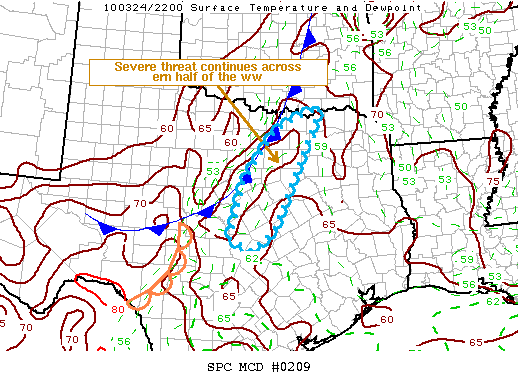
MESOSCALE DISCUSSION 0209
NWS STORM PREDICTION CENTER NORMAN OK
0629 PM CDT WED MAR 24 2010
AREAS AFFECTED...N CNTRL AND CNTRL TX
CONCERNING...SEVERE THUNDERSTORM WATCH 34...
VALID 242329Z - 250030Z
THE SEVERE WEATHER THREAT FOR SEVERE THUNDERSTORM WATCH 34
CONTINUES.
AN ISOLATED SEVERE THREAT WILL BE MAINTAINED ACROSS THE ERN HALF OF
THE SEVERE THUNDERSTORM WATCH. THE GREATEST THREAT WILL SHIFT SWD
INTO CNTRL TX LATER THIS EVENING...BUT IS EXPECTED TO REMAIN TOO
MARGINAL TO WARRANT AN ADDITIONAL SEVERE WW.
A LINE OF THUNDERSTORMS NEARLY COINCIDENT WITH THE ANALYZED SFC COLD
FRONT WILL CONTINUE TO MOVE EWD ACROSS N CNTRL TX...INCLUDING THE
DFW METROPLEX DURING THE NEXT HOUR. LATEST SFC ANALYSIS INDICATES A
NARROW INSTABILITY/THETA-E CORRIDOR IMMEDIATELY AHEAD OF THE
FRONT...CHARACTERIZED BY DEWPOINTS IN THE UPPER 50S AND LOWER 60S.
STRONGER CONVECTION HAS DEVELOPED FARTHER S ACROSS CNTRL TX...WHILE
STORMS N OF DFW HAVE EXHIBITED A NOTABLE WEAKENING TREND OVER THE
PAST HOUR.
WITH THE LOSS OF SOLAR HEATING...INSTABILITY WILL DECREASE TO AROUND
500 J/KG MUCAPE AND WILL BECOME MAXIMIZED FARTHER S IN CNTRL TX.
HOWEVER...INCREASING FORCED ASCENT ASSOCIATED WITH A MID-LEVEL VORT
MAX SHOULD HELP MAINTAIN CONVECTION AFTER SUNSET. ALTHOUGH LOW-LEVEL
WINDS ARE WEAK...SUFFICIENT DEEP LAYER SHEAR SHOULD SUPPORT EMBEDDED
SUPERCELL STRUCTURES WITHIN THE CONVECTIVE LINE. A MARGINAL
WIND/HAIL THREAT MAY STILL EXIST...BUT WILL LIKELY NOT REQUIRE AN
ADDITIONAL WW.
..ROGERS.. 03/24/2010
ATTN...WFO...FWD...OUN...EWX...
Re: March 2010- In Like A Lamb, Out Like A Lion?
Posted: Wed Mar 24, 2010 7:31 pm
by wxdata
D/FW NWS:
The Northern half/two-thirds of the line has been weakening and the severe weather threat is lowering. There is still some potential along the southern part of line...basically Hillsboro southward. We will be canceling some more counties out of the severe thunderstorm watch in the next 20-25 minutes. The potential for some flooding continues as the storms are slow moving.
Re: March 2010- In Like A Lamb, Out Like A Lion?
Posted: Wed Mar 24, 2010 8:02 pm
by wxdata
A bit interesting how the line of thunderstorms between Lampasas and Burnet is becoming 'wavy.'
Re: March 2010- In Like A Lamb, Out Like A Lion?
Posted: Wed Mar 24, 2010 8:32 pm
by Ptarmigan
wxdata wrote:A bit interesting how the line of thunderstorms between Lampasas and Burnet is becoming 'wavy.'
Looks like the wind is stronger in the storm. I expect thunderstorms while we sleep. Another nighttime thunderstorm.
Re: March 2010- In Like A Lamb, Out Like A Lion?
Posted: Wed Mar 24, 2010 8:57 pm
by wxdata
MESOSCALE DISCUSSION 0210
NWS STORM PREDICTION CENTER NORMAN OK
0856 PM CDT WED MAR 24 2010
AREAS AFFECTED...ECNTRL TX
CONCERNING...SEVERE THUNDERSTORM WATCH 34...
VALID 250156Z - 250330Z
THE SEVERE WEATHER THREAT FOR SEVERE THUNDERSTORM WATCH 34
CONTINUES.
AN ISOLATED SEVERE THREAT WILL BE MAINTAINED WITH A LINE CURRENTLY
MOVING THROUGH THE AUSTIN AREA. HAIL AND STRONG WIND GUSTS WILL BE
POSSIBLE ESEWD TOWARD THE BRENHAM...COLLEGE STATION AND HEMPSTEAD
AREAS LATER THIS EVENING. THE SEVERE THREATS ARE EXPECTED TO REMAIN
TOO MARGINAL TO WARRANT THE ISSUANCE OF A SEVERE WEATHER WATCH.
A MULT-SEGMENTED LINE FROM NEAR DALLAS SSWWD TO JUST NORTH OF SAN
ANTONIO IS LOCATED ALONG THE AXIS OF A NARROW CORRIDOR OF
INSTABILITY. OBJECTIVE ANALYSIS CURRENTLY SHOWS THE MOST INSTABILITY
CONCENTRATED FROM NEAR AUSTIN SSWWD WITH SBCAPE VALUES GENERALLY IN
THE 500 TO 1000 J/KG RANGE. INSTABILITY SHOULD GRADUALLY WEAKEN THIS
EVENING RESULTING IN AN INCREASINGLY MARGINAL SEVERE THREAT. TWO
SOMEWHAT ORGANIZED BOWING LINE-SEGMENTS ARE ONGOING ON THE SRN END
OF THE LINE. THESE STORMS WILL MOVE ESEWD AND SHOULD HAVE ACCESS TO
SFC DEWPOINTS NEAR 60 F. THIS COMBINED WITH INCREASING LOW-LEVEL
FLOW MAY RESULT IN POTENTIAL FOR STRONG WIND GUSTS OVER THE NEXT 1
TO 2 HOURS.
Re: March 2010- In Like A Lamb, Out Like A Lion?
Posted: Wed Mar 24, 2010 9:03 pm
by wxdata
Radar GRK showing winds over 70mph 800 ft above the surface just west of the radar.
Re: March 2010- In Like A Lamb, Out Like A Lion?
Posted: Wed Mar 24, 2010 9:05 pm
by wxdata
Winds over 80mph 800 ft off the ground just west of the GRK radar.
Re: March 2010- In Like A Lamb, Out Like A Lion?
Posted: Wed Mar 24, 2010 9:08 pm
by wxdata
SPECIAL WEATHER STATEMENT
NATIONAL WEATHER SERVICE HOUSTON/GALVESTON TX
904 PM CDT WED MAR 24 2010
TXZ195>197-211-250400-
AUSTIN-BRAZOS-BURLESON-WASHINGTON-
904 PM CDT WED MAR 24 2010
...SIGNIFICANT WEATHER ADVISORY...
AT 904 PM CDT...NATIONAL WEATHER SERVICE DOPPLER RADAR INDICATED
STRONG THUNDERSTORMS ALONG A LINE EXTENDING FROM WACO TO GRANGER TO
AUSTIN...MOVING EAST AT 40 MPH.
WINDS GREATER THAN 40 MPH...FREQUENT CLOUD TO GROUND
LIGHTNING...BRIEF HEAVY DOWNPOURS...AND SMALL HAIL ARE ALL POSSIBLE
WITH THIS STORMS AS THEY MOVE INTO THE BRAZOS VALLEY AREA BETWEEN
930 PM AND 1030 PM.
LOCATIONS IN THE PATH OF THESE STORMS INCLUDE...WELLBORN...QUARRY...
MILLICAN...KURTEN...INDEPENDENCE...CHRIESMAN...WIXON VALLEY...
SNOOK...COLLEGE STATION...CALDWELL...BURTON...BRYAN AND BRENHAM.
Re: March 2010- In Like A Lamb, Out Like A Lion?
Posted: Wed Mar 24, 2010 9:09 pm
by wxdata
Winds near Temple (Conley) reported at 60mph
Re: March 2010- In Like A Lamb, Out Like A Lion?
Posted: Wed Mar 24, 2010 9:14 pm
by wxdata
High winds just east of GRK radar at 9:06pm
Re: March 2010- In Like A Lamb, Out Like A Lion?
Posted: Wed Mar 24, 2010 9:21 pm
by sleetstorm
wxdata wrote:sleetstorm wrote:One thing that I do not like about this new weather forum, and I just now found this out, is that Font Color selection bar is only coded with letters and numbers and it is not shown even when you press the Font Hue button. Someone very seriously needs to work on that knowing that it is needless to say a downside to this forum.
Why is that even important? Just select the color you want, and be done with it..
I honestly did not mean any insult to you, srainhoutx, or the KHOU staff. I am truly thankful that we have a new forum to enjoy just like everyone else on this forum is.

Re: March 2010- In Like A Lamb, Out Like A Lion?
Posted: Wed Mar 24, 2010 9:26 pm
by wxdata
I honestly did not mean any insult to you, srainhoutx, or the KHOU staff. I am truly thankful that we have a new forum to enjoy just like everyone else on this forum is.

LOL, you didn't. I was just curious about the concerns with the colors that's all....
Re: March 2010- In Like A Lamb, Out Like A Lion?
Posted: Wed Mar 24, 2010 9:45 pm
by wxdata
BULLETIN - EAS ACTIVATION REQUESTED
SEVERE THUNDERSTORM WARNING
NATIONAL WEATHER SERVICE HOUSTON/GALVESTON TX
944 PM CDT WED MAR 24 2010
THE NATIONAL WEATHER SERVICE IN LEAGUE CITY HAS ISSUED A
* SEVERE THUNDERSTORM WARNING FOR...
BRAZOS COUNTY IN SOUTHEAST TEXAS...
BURLESON COUNTY IN SOUTHEAST TEXAS...
* UNTIL 1045 PM CDT
* AT 942 PM CDT...NATIONAL WEATHER SERVICE DOPPLER RADAR INDICATED A
LINE OF SEVERE THUNDERSTORMS. THESE STORMS WERE LOCATED ALONG A
LINE EXTENDING FROM ROSEBUD TO ROCKDALE TO ELGIN...AND WERE MOVING
EAST AT 40 MPH. THESE STORMS HAVE A HISTORY OF PRODUCING STRONG
WINDS UP TO 60 MPH.
* LOCATIONS IN THE SEVERE THUNDERSTORM WARNING INCLUDE BUT ARE NOT
LIMITED TO CHRIESMAN...SOMERVILLE...COLLEGE STATION...BRYAN...
WIXON VALLEY AND BRYAN.
Re: March 2010- In Like A Lamb, Out Like A Lion?
Posted: Wed Mar 24, 2010 9:54 pm
by sleetstorm
wxdata wrote:I honestly did not mean any insult to you, srainhoutx, or the KHOU staff. I am truly thankful that we have a new forum to enjoy just like everyone else on this forum is.

LOL, you didn't. I was just curious about the concerns with the colors that's all....
Honestly, I would just like to know what hue that I select, like I was able to in the old forum, rather than have to guess which hue that I it is & I am sure that other people would too.
Re: March 2010- In Like A Lamb, Out Like A Lion?
Posted: Wed Mar 24, 2010 9:55 pm
by wxdata
I'll do some homework and see if there is another option for the color picker utility....
Re: March 2010- In Like A Lamb, Out Like A Lion?
Posted: Wed Mar 24, 2010 10:18 pm
by wxdata
Nice weak bow echo just northwest of Bryan,
Re: March 2010- In Like A Lamb, Out Like A Lion?
Posted: Wed Mar 24, 2010 10:26 pm
by wxdata
It appears that metro Houston will stay on the extreme southern fringe of the line of storms,,
