
The CPC sees this further east.
October 2023
-
Cpv17
- Posts: 6801
- Joined: Fri Aug 31, 2018 1:58 pm
- Location: El Campo/Wharton
- Contact:

-
Ptarmigan

- Statistical Specialist

- Posts: 4429
- Joined: Wed Feb 03, 2010 7:20 pm
- Contact:
-
Ptarmigan
- Statistical Specialist
- Posts: 4429
- Joined: Wed Feb 03, 2010 7:20 pm
- Contact:
-
snowman65

- Posts: 1373
- Joined: Thu Feb 04, 2010 6:39 am
- Location: Orange, Tx
- Contact:
Man... walking outside and taking in a deep, cold breath... its hard to believe that it will be 90 Saturday.. welcome to SE Tx 

-
tireman4

- Global Moderator

- Posts: 6730
- Joined: Wed Feb 03, 2010 9:24 pm
- Location: Humble, Texas
- Contact:
000
FXUS64 KHGX 171120
AFDHGX
Area Forecast Discussion
National Weather Service Houston/Galveston TX
620 AM CDT Tue Oct 17 2023
...New AVIATION...
.SHORT TERM...
(Today through Wednesday Night)
Issued at 227 AM CDT Tue Oct 17 2023
Surface high pressure will be in the process of moving east of the
region this afternoon and tonight. With onshore flow resuming, look
for a gradual increase in temperatures and cloud cover heading thru
the midweek time period.
47
&&
.LONG TERM...
(Thursday through Monday)
Issued at 227 AM CDT Tue Oct 17 2023
An upper level trough axis (spanning from the Upper Mississippi
River Valley to the ArkLaTex region) should dig towards the Ohio
Valley/SE CONUS on Thursday. This feature will drape a weak cold
front across SE Texas late in the work week. This frontal boundary
is progged to reach the Brazos valley Thursday morning, slowly
pushing south overnight, then eventually reaching the coastline mid
Friday morning. PWs manage to pool above 1" ahead of the FROPA,
which may be sufficient for isolated showers/storms. Otherwise,
this should by-in-large be a dry FROPA. Drier conditions brought
by the FROPA and increased 850mb temperatures should bring highs
in the 80s/lower 90s for Friday. These dry conditions and clear
skies should also provide effective radiative cooling, bringing
lows in the 50s/60s for Friday night.
Surface high pressure passes over the region early Saturday,
drifting drifting east of the state and allowing onshore flow to
resume during the day. This will usher in moisture return through
the weekend and into next week. Dewpoints on Sunday rise into the
50s/60s, bringing lows in the 60s/lower 70s. By Monday, PWs climb
above 1.0 inch, exceeding 1.5 inches at the end of the long term.
Strengthening onshore flow and isentropic lifting may bring
isolated showers early next week, primarily over the Gulf waters.
03
&&
.AVIATION...
(12Z TAF Issuance)
Issued at 618 AM CDT Tue Oct 17 2023
Mainly VFR for the next 24+ hours. Cannot totally rule out some
very shallow ground fog before sunrise Wed at LBX and more rural
locations. 47
&&
.MARINE...
Issued at 227 AM CDT Tue Oct 17 2023
Light, predominantly offshore winds are expected across the Gulf
waters this morning. Onshore flow should return late this afternoon
as surface high pressure drifts east of the state. Winds strengthen
slightly into Wednesday, becoming southwesterly on Thursday ahead of
a weak cold front. This front should push offshore by Friday
morning, bringing west to northwest winds into Saturday. Onshore
flow resumes Saturday afternoon. Seas will range from 1 to 3 feet
over the next several days.
03
&&
.PRELIMINARY POINT TEMPS/POPS...
College Station (CLL) 76 50 82 60 / 0 0 0 0
Houston (IAH) 75 54 81 62 / 0 0 0 0
Galveston (GLS) 72 66 79 71 / 0 0 0 0
&&
.HGX WATCHES/WARNINGS/ADVISORIES...
TX...None.
GM...None.
&&
$$
-
Cpv17
- Posts: 6801
- Joined: Fri Aug 31, 2018 1:58 pm
- Location: El Campo/Wharton
- Contact:
The GFS operational and its ensemble are both showing a decent signal for rain next week. The Euro isn’t onboard though.
-
Stratton20
- Posts: 5595
- Joined: Tue Feb 09, 2021 11:35 pm
- Location: College Station, Texas
- Contact:
Cpv17 not surprising, the euro is always last to join the party every time lol
-
Stratton20
- Posts: 5595
- Joined: Tue Feb 09, 2021 11:35 pm
- Location: College Station, Texas
- Contact:
Ensemble guidance is trending toward more chilly weather the week of halloween, we will see, but the signal is growing, even the 18z GFS is getting really intriguing
-
DoctorMu

- Posts: 7597
- Joined: Sun Jun 28, 2015 11:58 am
- Location: College Station
- Contact:
-
DoctorMu
- Posts: 7597
- Joined: Sun Jun 28, 2015 11:58 am
- Location: College Station
- Contact:
The next big cold FROPA per GFS, CMC, Ensembles is about Oct 27.
-
tireman4
- Global Moderator
- Posts: 6730
- Joined: Wed Feb 03, 2010 9:24 pm
- Location: Humble, Texas
- Contact:
00
FXUS64 KHGX 181122
AFDHGX
Area Forecast Discussion
National Weather Service Houston/Galveston TX
622 AM CDT Wed Oct 18 2023
...New AVIATION...
.SHORT TERM...
(Today through Thursday Night)
Issued at 257 AM CDT Wed Oct 18 2023
It`s another cool start to the day across southeast Texas with
temperatures predominantly in the 50s. There are areas of patchy
fog. Any fog should break by mid-morning at the latest. Today will
be another pleasant day, albeit a little warmer due to return flow
on the back side of an eastward progressing surface high pressure
system. Most areas are expected to warm into the low-80s which is
pretty normal for this time of year. The aforementioned return flow
from the Gulf will also help to gradually increase dew points
throughout the day. Dew points over the southern half of the CWA
will likely be in the 60s by the afternoon. Tonight will be
seasonably mild with lows generally in the low/mid-60s (upper-50s
northern counties, near 70F at the coast).
Another front will approach the region on Thursday. We are not
anticipating any rainfall associated with the front. Moist, warm,
southerly flow from the Gulf will result in a summer-ish feel ahead
of the boundary, bringing highs well into the 80s with dew points in
the 60s. As the front pushes southward, winds will shift to a more
westerly direction by the afternoon. Perhaps this will be enough to
push lower dew points into our northern and western counties by
day`s end. With drier air in place, Thursday night`s temperatures
are expected to drop a few more degrees than the night before
(generally upper-50s to low-60s).
Self
&&
.LONG TERM...
(Friday through Tuesday)
Issued at 257 AM CDT Wed Oct 18 2023
Upper level ridging stretching from Mexico into the Rockies will
maintain a dry nw flow aloft Friday. In the lower levels, ridging
sets up across the west central Gulf which should provide wsw
winds locally. Combination of both is a favorable set-up for
efficient warming. Currently have highs topping out in the 89-92
degree range for now for Friday, but wouldn`t doubt if these
might need to be tweaked up a touch in the days to come.
A diffuse, decaying frontal boundary will sag southward into parts of
the area Fri afternoon and night, but not anticipating any of us will
notice as it`ll just maintain some lower dewpoints and allow for overnight
readings to cool back into the 60s Friday night.
This boundary will washout during the day Saturday and onshore
winds will gradually resume. Upper ridging will flatten later this
weekend into early next week as the next western trof digs down
into the Desert Southwest and western Mexico. It`ll probably scoop
up moisture from the eventual remnants of what is currently TS
Norma in the eastern Pacific, but general trajectory should keep
better rain chances well to our nw. Locally, into midweek, we`ll
probably just see increasing s/se winds that`ll provide warm overnight
lows into the upper 60s to low 70s, daytime highs in the 80s, and
just some iso-sct waa shower chances. 47
&&
.AVIATION...
(12Z TAF Issuance)
Issued at 618 AM CDT Wed Oct 18 2023
With the lone exception of the areas experiencing patchy fog this
morning, VFR cigs and vis will prevail today. Any patchy fog
should break within the next hour or two. We will need to monitor
the potential for patchy fog again tonight. No reduced vis
mention in the TAFs for tonight as of this update.
&&
.MARINE...
Issued at 257 AM CDT Wed Oct 18 2023
Light onshore winds today and Thursday will veer to the west on
Friday as high pressure sets up across the west central Gulf. A
diffuse frontal boundary may briefly sag into the nearshore waters
Friday night or Saturday morning before washing out. Onshore
winds will then resume and increase heading into the early parts
of next week. With a long fetch setting up, seas should be on an
upward trend as well...possibly approaching SCEC/SCA territory
early-mid next week. 47
&&
.PRELIMINARY POINT TEMPS/POPS...
College Station (CLL) 82 59 87 57 / 0 0 0 0
Houston (IAH) 82 62 87 61 / 0 0 0 0
Galveston (GLS) 78 70 81 68 / 0 0 0 0
&&
.HGX WATCHES/WARNINGS/ADVISORIES...
TX...None.
GM...None.
&&
$$
SHORT TERM...Adams
LONG TERM....Adams
AVIATION...Self
MARINE...Adams
-
Cpv17
- Posts: 6801
- Joined: Fri Aug 31, 2018 1:58 pm
- Location: El Campo/Wharton
- Contact:
Latest CPC 6-10, 8-14 day forecasts are awesome!!
-
Stratton20
- Posts: 5595
- Joined: Tue Feb 09, 2021 11:35 pm
- Location: College Station, Texas
- Contact:
Cpv17 no kidding! Those precipitation outlooks are a work of art! And we might get an early tease of winter in that time as well, definitely looking great down the road
 And we might get an early tease of winter in that time as well, definitely looking great down the road
-
DoctorMu
- Posts: 7597
- Joined: Sun Jun 28, 2015 11:58 am
- Location: College Station
- Contact:
Pretty sweet in pictures:


-
DoctorMu
- Posts: 7597
- Joined: Sun Jun 28, 2015 11:58 am
- Location: College Station
- Contact:
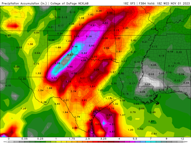
GFS, CMC, Euro all showing 2 FROPA with rain in the last week of October October 26-27 and the 30/31st.
-
MontgomeryCoWx

- Posts: 2641
- Joined: Wed Dec 14, 2011 4:31 pm
- Location: Weimar, TX
- Contact:
-
Pas_Bon
- Posts: 920
- Joined: Tue Sep 11, 2018 7:58 am
- Location: League City, TX
- Contact:
Cold? Never heard of her.MontgomeryCoWx wrote: ↑Wed Oct 18, 2023 9:18 pmWeather looks great that last week into November.
November looks fairly average which means we could be in for a cool to cold December.
-
Cromagnum
- Posts: 3018
- Joined: Thu Feb 03, 2011 10:42 pm
- Location: Georgetown
- Contact:
The cold needs to hurry up and come back to shut down these damned mosquitoes. They are God awful right now.
-
DoctorMu
- Posts: 7597
- Joined: Sun Jun 28, 2015 11:58 am
- Location: College Station
- Contact:
Then a warm January. Followed by a February winter storm.MontgomeryCoWx wrote: ↑Wed Oct 18, 2023 9:18 pmWeather looks great that last week into November.
November looks fairly average which means we could be in for a cool to cold December.