Page 18 of 23
Re: April 2024
Posted: Sun Apr 28, 2024 3:48 pm
by DoctorMu
Some small cells are trying to form off the inflow to that tornadic supercell near Franklin. Better be careful what I wish for!
Re: April 2024
Posted: Sun Apr 28, 2024 3:58 pm
by don
- IMG_0207.gif (50.27 KiB) Viewed 2423 times
Re: April 2024
Posted: Sun Apr 28, 2024 4:18 pm
by tireman4
Radar
Re: April 2024
Posted: Sun Apr 28, 2024 4:30 pm
by don
Re: April 2024
Posted: Sun Apr 28, 2024 4:34 pm
by Stratton20
Hopefully no severe weather

Re: April 2024
Posted: Sun Apr 28, 2024 4:50 pm
by Cpv17
It’s too windy and too overcast for anything to really get going. This isn’t the kind of conditions you need for a severe weather outbreak.
Re: April 2024
Posted: Sun Apr 28, 2024 4:51 pm
by Cpv17
don wrote: ↑Sun Apr 28, 2024 4:30 pm
There may be some strong thunderstorms late tonight for areas
along and east of I-45.As the storm clusters to the north eventually form into a MCS and moves southeast with the frontal boundary. It's MCS season in the southern plains...

Screenshot 2024-04-28 at 16-17-00 Models HRRR - Pivotal Weather.png
Screenshot 2024-04-28 at 16-26-30 Models HRRR - Pivotal Weather.pngScreenshot 2024-04-28 at 16-26-44 Models HRRR - Pivotal Weather.png
Well maybe 25% of the viewing area can get something then lol
Re: April 2024
Posted: Sun Apr 28, 2024 5:20 pm
by Pas_Bon
I’m feeling like I will miss out on rain in League City.
Re: April 2024
Posted: Sun Apr 28, 2024 5:23 pm
by DoctorMu
Inflow FTW. Don't discount it folks SE of CLL. It just started raining at last.
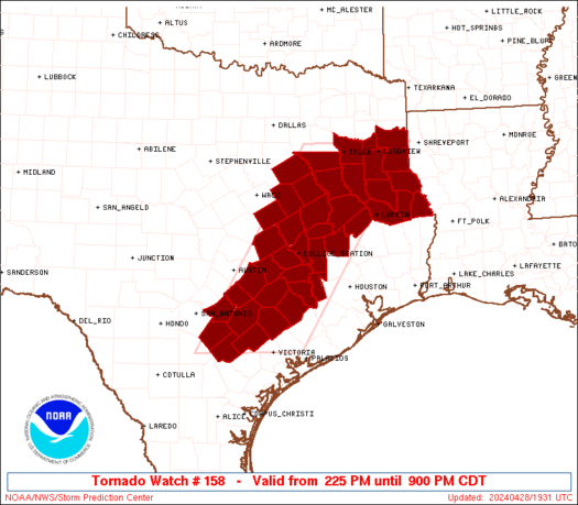
Special Weather Statement issued April 28 at 5:10PM CDT by NWS Houston/Galveston TX
At 509 PM CDT, Doppler radar was tracking a strong thunderstorm near
Snook, or 7 miles southwest of College Station, moving northeast at
35 mph.
HAZARD...Wind gusts up to 40 mph and pea size hail.
SOURCE...Radar indicated.
IMPACT...Gusty winds could knock down tree limbs and blow around
unsecured objects. Minor hail damage to vegetation is
possible.
Locations impacted include...
College Station, Bryan, Snook, Kyle Field, and Wellborn.
Instructions
If outdoors, consider seeking shelter inside a building.
A Tornado Watch remains in effect until 900 PM CDT for southeastern
Texas.
Re: April 2024
Posted: Sun Apr 28, 2024 5:33 pm
by DoctorMu
The cell is deepening and potentially over us per NWS weather. Forming a hail core?? We'll see.
Re: April 2024
Posted: Sun Apr 28, 2024 5:53 pm
by Cpv17
Pas_Bon wrote: ↑Sun Apr 28, 2024 5:20 pm
I’m feeling like I will miss out on rain in League City.
It doesn’t look like much for areas south of I-10.
Re: April 2024
Posted: Sun Apr 28, 2024 5:57 pm
by DoctorMu
Those small cells in Grimes Co mean business. Can see some shear up in the clouds now. Keep an eye out. There could be a severe store forming eventually in Harris Co.
Re: April 2024
Posted: Sun Apr 28, 2024 6:25 pm
by Stratton20
Looks like its going to be a non event for much of se texas with the exception of northern counties, i really sont see much development out west, mostly NE near college station
Re: April 2024
Posted: Sun Apr 28, 2024 6:28 pm
by Cromagnum
So much for that "wet spring" and "wet April". What a joke.
Re: April 2024
Posted: Sun Apr 28, 2024 6:45 pm
by tireman4
Nasty Tornado warned storm near Madisonville
Re: April 2024
Posted: Sun Apr 28, 2024 6:46 pm
by Scott747
Possibee large wedge tornado up near Madisonville.
Re: April 2024
Posted: Sun Apr 28, 2024 6:54 pm
by DoctorMu
tireman4 wrote: ↑Sun Apr 28, 2024 6:45 pm
Nasty Tornado warned storm near Madisonville
That was the cell that formed over us and bombed over Grimes Co.
Re: April 2024
Posted: Sun Apr 28, 2024 6:58 pm
by DoctorMu
Scott747 wrote: ↑Sun Apr 28, 2024 6:46 pm
Possibee large wedge tornado up near Madisonville.
Potentially over Madisonville...
https://x.com/SimonStormRider/status/17 ... 8384517607
https://x.com/fargussmedia/status/1784734303903212001
Re: April 2024
Posted: Sun Apr 28, 2024 7:00 pm
by DoctorMu
Another cell is forming over us now. Grimes and Madison Cos get prepared for even more nasty stuff...
Re: April 2024
Posted: Sun Apr 28, 2024 7:02 pm
by don
Stratton20 wrote: ↑Sun Apr 28, 2024 6:25 pm
Looks like its going to be a non event for much of se texas with the exception of northern counties, i really sont see much development out west, mostly NE near college station
Are y'all looking at mesoscale models?

The storms to the Northeast are the same storms that will congeal into a MCS and move southeast with the front late tonight/overnight.This MCS looks to effect areas along and east of I-45 all the way to the coast.I'm
not concerned about severe weather in metro Houston, but looking forward to some heavy rain even if only brief.
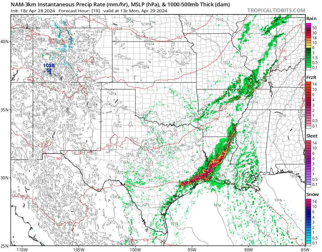
- nam3km_mslp_pcpn_frzn_scus_19.png (247.69 KiB) Viewed 2307 times
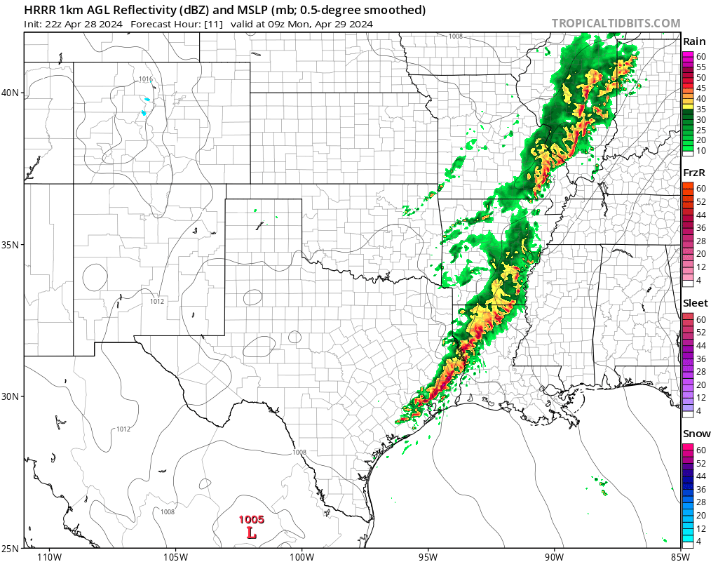
- hrrr_ref_frzn_scus_11.png (153.13 KiB) Viewed 2307 times


 The storms to the Northeast are the same storms that will congeal into a MCS and move southeast with the front late tonight/overnight.This MCS looks to effect areas along and east of I-45 all the way to the coast.I'm not concerned about severe weather in metro Houston, but looking forward to some heavy rain even if only brief.