
April 2015: Pleasant Weather To End April
-
BlueJay
- Posts: 938
- Joined: Tue Mar 04, 2014 10:47 am
- Location: Alden Bridge-The Woodlands, Texas
- Contact:
We are being rained on.
-
Katdaddy

- Global Moderator

- Posts: 2521
- Joined: Thu Feb 04, 2010 8:18 am
- Location: League City, Tx
- Contact:
Rain chances will remain at 60% through Monday. There will be some isolated areas of locally heavy rainfall where the storms cluster. This morning there are heavy thundershowers in Galveston and Brazoria Counties SE of Houston metro.
-
JulieC
- Posts: 52
- Joined: Sun Jan 30, 2011 9:13 pm
- Contact:
I thought today was supposed to be a washout, where is the rain?
-
Ptarmigan

- Statistical Specialist

- Posts: 4431
- Joined: Wed Feb 03, 2010 7:20 pm
- Contact:
000
FXUS64 KHGX 121959
AFDHGX
AREA FORECAST DISCUSSION
NATIONAL WEATHER SERVICE HOUSTON/GALVESTON TX
259 PM CDT SUN APR 12 2015
.DISCUSSION...
SCATTERED SHOWERS HAVE BEGUN TO DEVELOP ACROSS PARTS OF SOUTHEAST
TEXAS THIS AFTERNOON AS BREAKS IN THE CLOUDS HAVE BROUGHT SOME OF
OUR TEMPERATURES (2 PM READINGS) CLOSE TO 80 DEGREES. EXPECT ACTIVITY
TO CONTINUE TO DEVELOP DURING THE REST OF THE AFTERNOON WITH SOME
THUNDER AND BRIEF LOCALLY HEAVY RAINFALL POSSIBLE TOO. MUCH OF THE
AREA SHOULD SEE A BREAK THIS EVENING...THEN A FAST EASTWARD MOVING
STORM COMPLEX (SHOWERS/THUNDERSTORMS WITH LOCALLY HEAVY RAINFALL AND
POSSIBLY SOME STRONG GUSTY WINDS TOO) IS ANTICIPATED TO MOVE INTO
MUCH OF OUR CENTRAL AND SOUTHERN AREAS FROM THE WEST DURING THE
OVERNIGHT THROUGH EARLY MORNING HOURS. IF WE CAN HANDLE WHAT RAIN
FALLS OVER THE NEXT SEVERAL HOURS...CURRENT THINKING IS THAT WE
SHOULD BE ABLE TO HANDLE THE OVERNIGHT SYSTEM AND ITS HEAVY RAINFALL
TOO DUE TO ITS EXPECTED FAST EASTWARD MOVEMENT. THE GREATEST RISK FOR
SEVERE STORM DEVELOPMENT WITH THESE STORMS WILL BE OFF TO OUR WEST
AND SOUTHWEST WHERE SPC HAS PARTS OF THE STATE UNDER THEIR DAY 1
SLIGHT RISK. BACK OVER HERE FOR THE REST OF TODAY AND ON THROUGH
MONDAY...RAINFALL TOTALS ARE EXPECTED TO AVERAGE AROUND 1 INCH WITH
ISOLATED 2 TO 4 INCHES POSSIBLE WITH THE STRONGER ACTIVITY. WILL
CARRY LOWER RAIN CHANCES AS WE HEAD INTO THE AFTERNOON HOURS TOMORROW
DUE TO EXPECTED TEMPORARY STABILIZATION...BUT THE SLOW MOVING WEST
TEXAS MID/UPPER LEVEL LOW COULD SUPPORT MORE STORM DEVELOPMENT AS
WE HEAD ON INTO MONDAY NIGHT AND TUESDAY. OUR AREA IS EXPECTED TO
REMAIN IN A SOUTHWEST FLOW ALOFT FOR MUCH OF NEXT WEEK...AND THIS
SHOULD PROVIDE US WITH ADDITIONAL PERIODS OF SHOWERS AND THUNDERSTORMS.
HAVE NOW EXTENDED RAIN CHANCES ON INTO NEXT SATURDAY AS THE PREVIOUSLY
ADVERTISED COLD FRONT LOOKS DELAYED ONCE AGAIN. 42
&&
.MARINE...
SHOWERS AND THUNDERSTORMS WILL CONTINUE OVER THE COASTAL WATERS THIS
AFTERNOON AND EVENING. ANOTHER ROUND OF STORMS ARE POSSIBLE LATE
TONIGHT AND INTO MONDAY MORNING AS AN UPPER LEVEL DISTURBANCE
APPROACHES FROM THE WEST... WITH LOCALLY ELEVATED WINDS AND SEAS
POSSIBLE NEAR ANY STORM. MESSY SOUTHWEST FLOW ALOFT WILL CONTINUE
THROUGH THE REMAINDER OF THE WEEK WITH AN EFFECTIVE SHORTWAVE PARADE
KEEPING THE POSSIBILITY OF THUNDERSTORMS OVER THE COASTAL WATERS
INTO NEXT WEEKEND. GUIDANCE STILL WAFFLING A BIT REGARDING THE COLD
FRONT ON TUESDAY... WITH SOME INDICATION THAT IT MAY REACH PARTS OF
THE MIDDLE TO UPPER TEXAS COAST SOMETIME TUESDAY MORNING. ANY WIND
SHIFT ASSOCIATED WITH THIS WOULD BE BRIEF... WITH LIGHT TO
OCCASIONALLY MODERATE ONSHORE FLOW PERSISTING THROUGH THE WEEK.
ANOTHER COLD FRONT REMAINS POSSIBLE FOR THE COASTAL WATERS NEXT
WEEKEND.
HUFFMAN
&&
.AVIATION...
SCATTERED CONVECTION CONTINUES TO DEVELOP ACROSS AREA TAF SITES THIS
AFTERNOON. MAIN CONCERN FOR THE TERMINALS WOULD BE LIGHTNING AND
BRIEF HEAVY RAIN... WITH A FEW ISOLATED STRIKES HAVING ALREADY BEEN
OBSERVED THIS AFTERNOON. UPDATED TAFS TO REFLECT TEMPO MENTION OF
TSRA THROUGH 23Z. ADDITIONALLY... KHGX VAD WIND PROFILER IS SHOWING
15 TO 20 KNOT WINDS JUST OFF THE SURFACE THIS AFTERNOON AND A FEW
ISOLATED... ELEVATED GUSTS NEAR TSRA MAY BE POSSIBLE AS WELL.
HUFFMAN
&&
http://forecast.weather.gov/product.php ... glossary=1
Looks like we could have rain and thunderstorms tonight to early tomorrow morning.
-
srainhoutx

- Site Admin

- Posts: 19699
- Joined: Tue Feb 02, 2010 2:32 pm
- Location: Maggie Valley, NC
- Contact:
A Severe Thunderstorm Watch has been issued for a large portion of South and portions of SW Texas. A very large line of strong to severe storms extends from Monterrey where golf ball size hail has been observed extending N into West Texas just W of the Permian Basin. This large area of severe storms appear to be organizing into a squall line with 1 to 2 mb per hour pressure falls being reported across S Texas and the Lower Rio Grande Valley. The movement of this area of organizing storms is shifting E and may approach the Middle and Upper Texas Coast near daybreak.

Carla/Alicia/Jerry(In The Eye)/Michelle/Charley/Ivan/Dennis/Katrina/Rita/Wilma/Humberto/Ike/Harvey
Member: National Weather Association
Facebook.com/Weather Infinity
Twitter @WeatherInfinity
Member: National Weather Association
Facebook.com/Weather Infinity
Twitter @WeatherInfinity
-
Ptarmigan
- Statistical Specialist
- Posts: 4431
- Joined: Wed Feb 03, 2010 7:20 pm
- Contact:
Some nasty storms in South Texas.


The storms in Central Texas are impressive.

The storms in Central Texas are impressive.
-
Paul Robison
Am I imagining things, or are those storms on the radar that Ptarmigan posted actually intensifying rather than dissipating? Kinda would like to know before I go to bed.
-
srainhoutx
- Site Admin
- Posts: 19699
- Joined: Tue Feb 02, 2010 2:32 pm
- Location: Maggie Valley, NC
- Contact:
The MCS (mesoscale convective system) and the squall line offshore are producing storms across portions of SE Texas early this morning and could lead to a messy morning commute. The atmosphere likely will be worked over and take into the afternoon/evening hours to recharge and expect a new area of storms to organize across the Hill Country and move E as a weak frontal boundary drapes across the Region. The pesky upper low to our NW looks to be absorbed into the generally slow moving split flow before yet another strong upper low drops into the 4 Corners Region Wednesday. That upper air feature should once again set the stage for an unsettled pattern Thursday into Friday and possibly extending into Saturday. As a note, Monterrey,MX and the Lower Rio Grande Valley are very wet due to unusually high rainfall all Winter into early Spring. The cotton farmers are struggling in the RGV due to an exceptionally wet pattern and that may continue with additional heavy rainfall expected this week. Portions of Galveston County received 8+ inches of rainfall so far from this messy unsettled pattern since last Thursday.
Carla/Alicia/Jerry(In The Eye)/Michelle/Charley/Ivan/Dennis/Katrina/Rita/Wilma/Humberto/Ike/Harvey
Member: National Weather Association
Facebook.com/Weather Infinity
Twitter @WeatherInfinity
Member: National Weather Association
Facebook.com/Weather Infinity
Twitter @WeatherInfinity
-
BlueJay
- Posts: 938
- Joined: Tue Mar 04, 2014 10:47 am
- Location: Alden Bridge-The Woodlands, Texas
- Contact:
We have received 0.47 inches since last Thursday.
Although that is not an impressive amount of rain, I will take it.
After 2011 - any rain is good rain!
Although that is not an impressive amount of rain, I will take it.
After 2011 - any rain is good rain!
-
srainhoutx
- Site Admin
- Posts: 19699
- Joined: Tue Feb 02, 2010 2:32 pm
- Location: Maggie Valley, NC
- Contact:
That meso low that rolled off the Sierra Madre Mountains that also led to the United flight from Las Vegas skidding off the runway while landing at IAH early this morning is shifting E. Visible satellite imagery clearly shows the main upper low spinning across Southern New Mexico and with a SW flow aloft and clearing skies across West and Central Texas, the SPC has issued a Slight Risk for severe storms later today across the Hill Country as the atmosphere destabilizes once again. Very heavy rainfall with heavy storms continue across Louisiana ahead of the MCV currently near Beaumont/Lake Charles.
Carla/Alicia/Jerry(In The Eye)/Michelle/Charley/Ivan/Dennis/Katrina/Rita/Wilma/Humberto/Ike/Harvey
Member: National Weather Association
Facebook.com/Weather Infinity
Twitter @WeatherInfinity
Member: National Weather Association
Facebook.com/Weather Infinity
Twitter @WeatherInfinity
-
srainhoutx
- Site Admin
- Posts: 19699
- Joined: Tue Feb 02, 2010 2:32 pm
- Location: Maggie Valley, NC
- Contact:
Morning briefing from Jeff:
Overnight S/SC TX MCS/bow echo has progressed quickly across SE TX in the last few hours while weakening. Main thrust of the related wind damage was across S TX to as far north as Matagorda Bay and then across the offshore Gulf waters. CRP radar early this morning was showing 50-70kts of rear flank inflow into the system and the current Houston radar shows a well defined MVC directly over Harris County lifting ENE. Palacios recorded 41mph of inflow wind out of the south at around 140am this morning.
Should see fairly rapid clearing and ending of showers/thunderstorms in the next few hours as current disturbance exits to the NE. Upstream air mass has been overturned and greatly stabilized by the widespread convection per meso analysis over S TX showing considerable CIN values and little to no CAPE. Clearing skies will begin the destabilization process by late morning, but models are usually too quick in the resulting unstable air mass behind such a strong convective system and with no defined upstream impulse heading for the region, think any additional development today will be spotty and along any old outflow boundaries from the overnight storms.
Upper level trough responsible for this wet pattern will remain anchored over the SW US all week with the next strong disturbance expected to affect the area Tuesday afternoon and evening. Air mass should have fully recovered by Tuesday afternoon and ready to support another round of storms. Timing of this activity in the afternoon and evening hours does raise the severe threat level some as the air mass will be most unstable toward and just after peak heating.
Wednesday appears to be the driest day of the week, but cannot rule out at least scattered showers developing in the afternoon heat.
Thursday-Saturday:
Another upper level trough digs into the SW US (sound familiar) with a surface cool front moving into the area. Model solutions have been trending slower and weaker with this front which was expected to move across the region on Thursday with clearing skies and drier weather for the weekend, but that appears in serious doubt at the moment. Instead the latest guidance redevelops the SW flow aloft bring several more disturbances across the region and maintains a very moist air mass allowing more rounds of thunderstorms Thursday and Friday. If the front does manage to work into the area it will only serve to focus thunderstorms and heavy rainfall in a more organized fashion.
Flood Threat:
Air mass remains extremely moist for mid April with moisture levels 150-200% of average for this time of year. Storms have been capable of producing very heavy rainfall rates of over 2 inches per hour, but have been moving quickly enough to limit the duration of the rainfall. Additionally, breaks between rounds of storms have been long enough to allow run-off the drain. This looks to continue with a more sustained rainfall threat Thursday/Friday in which the flood threat may be more elevated. Rises on area rivers and creeks is likely over the next few days as repeated rounds of storms move across the area.
Carla/Alicia/Jerry(In The Eye)/Michelle/Charley/Ivan/Dennis/Katrina/Rita/Wilma/Humberto/Ike/Harvey
Member: National Weather Association
Facebook.com/Weather Infinity
Twitter @WeatherInfinity
Member: National Weather Association
Facebook.com/Weather Infinity
Twitter @WeatherInfinity
-
BlueJay
- Posts: 938
- Joined: Tue Mar 04, 2014 10:47 am
- Location: Alden Bridge-The Woodlands, Texas
- Contact:
I've got to admit I was expecting gray and cloudy skies today but it is an amazingly beautiful spring day! I'm glad that I have a window view! 
-
Paul Robison
But the higher rainfall totals appear to be offshore, Srainhoutex. Last time I looked at the projected rainfall totals, Houston Metro came in with .17 inches expected, while our coastal counties and offshore came in with Galveston expected to accumulate .62. I'd say the severe threat seems to be more likely toward the coast as opposed to the Houston Metro, sir.srainhoutx wrote:Morning briefing from Jeff:
Upper level trough responsible for this wet pattern will remain anchored over the SW US all week with the next strong disturbance expected to affect the area Tuesday afternoon and evening. Air mass should have fully recovered by Tuesday afternoon and ready to support another round of storms. Timing of this activity in the afternoon and evening hours does raise the severe threat level some as the air mass will be most unstable toward and just after peak heating.
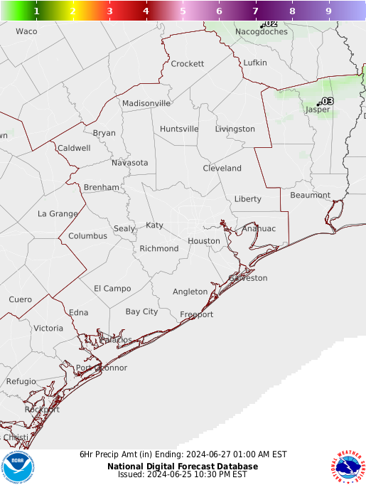
[img]C:\Users\robfam\Favorites\Links\QPF3_hgx[1].png[/img]
-
Katdaddy
- Global Moderator
- Posts: 2521
- Joined: Thu Feb 04, 2010 8:18 am
- Location: League City, Tx
- Contact:
The NWS has had and continues to have a challenging forecast due to a very slow moving upper level low and the timing of the disturbances in the SW flow aloft. Another disturbance located across STX this morning is forecast to move NE into SE TX and interact with a stalled frontal boundary which will likely lead to the development of showers and thunderstorms later today. The potential exist for heavy rainfall with localized flooding.
-
unome
- Posts: 3062
- Joined: Fri Feb 12, 2010 6:11 pm
-
unome
- Posts: 3062
- Joined: Fri Feb 12, 2010 6:11 pm
from Wundermap: http://horizon.wunderground.com/wundermap/
53mph gust at this station http://horizon.wunderground.com/history ... story.html

53mph gust at this station http://horizon.wunderground.com/history ... story.html
-
unome
- Posts: 3062
- Joined: Fri Feb 12, 2010 6:11 pm
power outage map https://aeptexas.com/outages/outageMap.aspx
Customer Outages
Last updated: 05:58 AM CT 04-14-2015
County, Customers Without Power, Total Customers, Percentage
Aransas Co., TX 968 19,161 5.1
Bee Co., TX 146 9,349 1.6
Brooks Co., TX 118 4,669 2.5
Duval Co., TX 362 6,685 5.4
Jim Wells Co., TX 529 14,968 3.5
Kleberg Co., TX 7,142 12,250 58.3
Nueces Co., TX 3,801 142,907 2.7
San Patricio Co., TX 3,098 29,357 10.6
Webb Co., TX 611 87,258 0.7
Total Outages 16,775 1,016,297 1.7
AEP Texas serves 1,016,297 customers in 87 counties in TX
Note: This system uses outage information reported by our customers to create a computer projection of the total number of customers affected by an outage event. During fast-changing situations – such as a major storm – the accuracy of this estimate can be affected by the large number of unusual situations that must be analyzed.
-
unome
- Posts: 3062
- Joined: Fri Feb 12, 2010 6:11 pm
-
srainhoutx
- Site Admin
- Posts: 19699
- Joined: Tue Feb 02, 2010 2:32 pm
- Location: Maggie Valley, NC
- Contact:
Morning briefing from Jeff:
Next upstream impulse in the SW flow aloft resulting in strong/severe MCS over the coastal bend this morning producing torrential rainfall rates.
Well defined thunderstorm complex extends from CRP to near VCT and moving E to ESE with the main thrust of the weather along the coast from CRP to Rockport. Hourly rainfall rates nearing 3.5-4.0 inches per hour just north of CRP where cell mergers have occurred….flash flooding is ongoing. Recent radar trends over the upper TX coastal waters show an increase in convective development over the Gulf waters as lift from this impulse arrives into SE TX. Think the majority of the heavy rains will be along the coast and offshore with a larger area of light to moderate rainfall affecting inland areas south of I-10. North of I-10, low level inflow of moisture will be cut off by storms over the Gulf and not expecting much activity today.
Should be between disturbances on Wednesday before things turn very wet Thursday into Friday. A slow moving frontal boundary will slowly move into the area while another nearly stationary upper level low cuts off over the SW US leading to multiple disturbances moving across the region. Moisture levels will remain very high for mid April and storm motions will be gradually slowing suggesting the overall threat for sustained excessive rainfall will be increased Thursday and Friday. Hard to time which day or time period will be the most active as we have seen over the past few days mesoscale influences can wreak havoc with the forecast.
While the overall pattern will be favorable for heavy rainfall and even a few severe storms the details in the mesoscale environment will dictate when and where such events may occur on Thursday and Friday. Models are still not in good agreement on if the area with dry out over the weekend or remain wet.
Carla/Alicia/Jerry(In The Eye)/Michelle/Charley/Ivan/Dennis/Katrina/Rita/Wilma/Humberto/Ike/Harvey
Member: National Weather Association
Facebook.com/Weather Infinity
Twitter @WeatherInfinity
Member: National Weather Association
Facebook.com/Weather Infinity
Twitter @WeatherInfinity
-
unome
- Posts: 3062
- Joined: Fri Feb 12, 2010 6:11 pm
crazy lightning
http://www.blitzortung.org/Webpages/ind ... &page_0=30
http://www.blitzortung.org/Webpages/ind ... =en&page=1
I hope I get a chance to sneak in a yard trim !

http://www.blitzortung.org/Webpages/ind ... &page_0=30
http://www.blitzortung.org/Webpages/ind ... =en&page=1
I hope I get a chance to sneak in a yard trim !