Re: January 2024
Posted: Mon Jan 08, 2024 2:35 pm
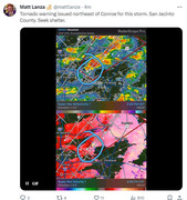
Tornado Warning
National Weather Service Houston/Galveston TX
207 PM CST Mon Jan 8 2024
The National Weather Service in League City has issued a
* Tornado Warning for... Northeastern Montgomery County in southeastern Texas... Southwestern San Jacinto County in southeastern Texas... Southwestern Polk County in southeastern Texas...
* Until 230 PM CST.
* At 206 PM CST, a severe thunderstorm capable of producing a tornado was located 9 miles southwest of Coldspring, or 12 miles northwest of Cleveland, moving northeast at 50 mph.
HAZARD...Tornado.
SOURCE...Radar indicated rotation.
IMPACT...Flying debris will be dangerous to those caught without shelter. Mobile homes will be damaged or destroyed. Damage to roofs, windows, and vehicles will occur. Tree damage is likely.
* This dangerous storm will be near... Coldspring around 210 PM CST. Shepherd, Lake Livingston State Park, and West Livingston around 215 PM CST. Livingston and Goodrich around 220 PM CST.
Other locations impacted by this tornadic thunderstorm include Evergreen.
PRECAUTIONARY/PREPAREDNESS ACTIONS...
TAKE COVER NOW! Move to a basement or an interior room on the lowest floor of a sturdy building. Avoid windows. If you are outdoors, in a mobile home, or in a vehicle, move to the closest substantial shelter and protect yourself from flying debris.
&&
TIME...MOT...LOC 2006Z 223DEG 49KT 3047 9522
TORNADO...RADAR INDICATED
MAX HAIL SIZE...<.75 IN
$$
Cady