General Weather Discussions and Analysis
unome
Posts: 3062Joined: Fri Feb 12, 2010 6:11 pm
Tue Aug 22, 2017 9:13 pm
http://www.nhc.noaa.gov/marine/forecast ... .php?large
GMZ001-231415-
Synopsis for the Gulf of Mexico
1001 PM EDT Tue Aug 22 2017
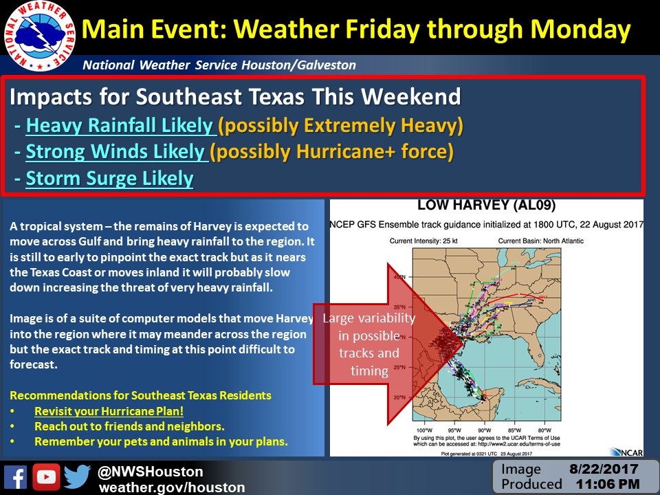
.SYNOPSIS...The remnant low of tropical cyclone Harvey has moved over water along the Yucatan coast near 21N91W at 1009 mb and will move NW across the SW Gulf through Wed, possibly becoming a tropical cyclone. The low will then continue NW across the west central and NW Gulf through Fri and is expected to strengthen.
stormlover
Posts: 439Joined: Wed Dec 04, 2013 10:21 amLocation: Lumberton TX
Contact:
Scott747
Posts: 1641Joined: Tue Feb 23, 2010 9:56 amLocation: Freeport/Surfside Beach
Contact:
Tue Aug 22, 2017 10:23 pm
Oz gfs is running. NCEP status message doesnt mention the dropsondes or special soundings. Have to believe they are in there regardless.
Scott747
Posts: 1641Joined: Tue Feb 23, 2010 9:56 amLocation: Freeport/Surfside Beach
Contact:
Tue Aug 22, 2017 10:39 pm
So far through 30 hrs looks a touch slower and slightly e.
Scott747
Posts: 1641Joined: Tue Feb 23, 2010 9:56 amLocation: Freeport/Surfside Beach
Contact:
Tue Aug 22, 2017 10:44 pm
Hr 48 it's still e and weaker. Looks like matagorda bay or n unless it slows and hooks back w.
Scott747
Posts: 1641Joined: Tue Feb 23, 2010 9:56 amLocation: Freeport/Surfside Beach
Contact:
Tue Aug 22, 2017 10:56 pm
Comes in around sargent as a cat 1 late friday/early saturday and then moving n towards houston
jasons2k
Posts: 6053Joined: Thu Feb 04, 2010 12:54 pmLocation: Imperial Oaks
Contact:
Tue Aug 22, 2017 10:57 pm
Yeah, and moving very slowly. Incredible rainfall and flooding over Houston Metro with this run.
davidiowx
Posts: 1169Joined: Thu Jan 23, 2014 2:39 pmLocation: Richmond, TX
Contact:
Tue Aug 22, 2017 11:01 pm
That was certainly not pleasant to see.. did that have the GIV data in it? Very similar to last nights run.
jasons2k
Posts: 6053Joined: Thu Feb 04, 2010 12:54 pmLocation: Imperial Oaks
Contact:
Tue Aug 22, 2017 11:11 pm
davidiowx wrote: That was certainly not pleasant to see.. did that have the GIV data in it? Very similar to last nights run.
Yes, full dropsonde data set in the 00Z runs.
DoctorMu
Posts: 7622Joined: Sun Jun 28, 2015 11:58 amLocation: College Station
Contact:
DoctorMu
Posts: 7622Joined: Sun Jun 28, 2015 11:58 amLocation: College Station
Contact:
sau27
Posts: 415Joined: Sat Apr 24, 2010 12:04 amLocation: Bellaire
Contact:
Tue Aug 22, 2017 11:21 pm
Looks like the 0z GFS gives us a bigger first punch than previous runs, but moved it out a little bit faster. Still 10-12+ inches of rain though.
srainhoutx
Site Admin
Posts: 19699Joined: Tue Feb 02, 2010 2:32 pmLocation: Maggie Valley, NC
Contact:
Tue Aug 22, 2017 11:42 pm
From James Spann via Twitter suggests much higher rainfall amounts across SE Texas from that GFS solution.
Attachments
Carla/Alicia/Jerry(In The Eye)/Michelle/Charley/Ivan/Dennis/Katrina/Rita/Wilma/Humberto/Ike/Harvey
unome
Posts: 3062Joined: Fri Feb 12, 2010 6:11 pm
unome
Posts: 3062Joined: Fri Feb 12, 2010 6:11 pm
Users browsing this forum: Google [Bot] and 14 guests


