
COASTAL HAZARD MESSAGE
NATIONAL WEATHER SERVICE HOUSTON/GALVESTON TX
1233 PM CDT FRI MAY 27 2016
...HIGH RIP CURRENT RISK THIS AFTERNOON AND TONIGHT...
.VERY STRONG RIP CURRENTS HAVE BEEN OBSERVED ON GALVESTON BEACH.
AVOID GOING INTO THE WATER OF GULF FACING BEACHES.
...HIGH RIP CURRENT RISK IN EFFECT UNTIL 10 PM CDT THIS EVENING...
THE NATIONAL WEATHER SERVICE IN HOUSTON/GALVESTON HAS ISSUED A HIGH RIP CURRENT RISK... WHICH IS IN EFFECT UNTIL 10 PM CDT THIS EVENING.
* TIMING...THIS AFTERNOON AND TONIGHT.
* IMPACTS... LIFE THREATENING RIP CURRENTS ALONG AREA BEACHES.
PRECAUTIONARY/PREPAREDNESS ACTIONS...
THERE IS A HIGH RISK OF RIP CURRENTS. LIFE THREATENING RIP CURRENTS ARE LIKELY IN THE SURF ZONE.
RIP CURRENTS ARE POWERFUL CHANNELS OF WATER FLOWING QUICKLY AWAY FROM SHORE... WHICH OCCUR MOST OFTEN AT LOW SPOTS OR BREAKS IN THE SANDBAR AND IN THE VICINITY OF STRUCTURES SUCH AS GROINS... JETTIES AND PIERS. HEED THE ADVICE OF LIFEGUARDS... BEACH PATROL... FLAGS AND SIGNS. SWIM NEAR A LIFEGUARD.
IF YOU BECOME CAUGHT IN A RIP CURRENT... YELL FOR HELP. REMAIN CALM... DO NOT EXHAUST YOURSELF AND STAY AFLOAT WHILE WAITING FOR HELP. IF YOU HAVE TO SWIM OUT OF A RIP CURRENT... SWIM PARALLEL TO SHORE AND BACK TOWARD THE BEACH WHEN POSSIBLE. DO NOT ATTEMPT TO SWIM DIRECTLY AGAINST A RIP CURRENT AS YOU WILL TIRE QUICKLY.
May 2016: Shower/Storm Chances To End May
-
unome
- Posts: 3062
- Joined: Fri Feb 12, 2010 6:11 pm
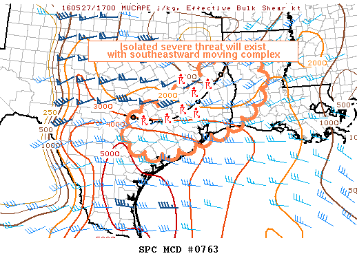
MESOSCALE DISCUSSION 0763
NWS STORM PREDICTION CENTER NORMAN OK
1257 PM CDT FRI MAY 27 2016
AREAS AFFECTED...SOUTHEASTERN TEXAS AND SOUTHWESTERN LOUISIANA
CONCERNING...SEVERE POTENTIAL...WATCH POSSIBLE
VALID 271757Z - 271900Z
PROBABILITY OF WATCH ISSUANCE...40 PERCENT
SUMMARY...A VERY ISOLATED SEVERE THREAT SHOULD CONTINUE WITH A
SLOWLY SOUTHEASTWARD MOVING MCS OVER THE DISCUSSION AREA.
DISCUSSION...WIDESPREAD CONVECTION ASSOCIATED WITH AN MCS TRAVERSING
THE REGION IS EXPECTED TO CONTINUE THROUGH THE AFTERNOON. MOST OF
THE CONVECTION IS UNDERCUT BY A SOUTHWARD MOVING COLD POOL LOCATED
FROM 20 S LUF TO 45 NW HOU TO NEAR BAZ. THE PRE-CONVECTIVE AIRMASS
AHEAD OF THIS MCS IS FAVORABLE FOR CONTINUED CONVECTIVE DEVELOPMENT
GIVEN STRONG DESTABILIZATION /OVER 4000 J/KG MUCAPE IN WESTERN PARTS
OF THE DISCUSSION AREA/ AND SUFFICIENT DEEP SHEAR /30-45 KNOTS/ FOR
STORM ORGANIZATION. SOME INCIDENCES OF HAIL MAY BE POSSIBLE
ESPECIALLY ALONG THE WESTERN PORTIONS OF THE DISCUSSION AREA...WHERE
MODIFIED POINT FORECAST SOUNDINGS ATOP THE COLD POOL REMAIN
MODERATELY UNSTABLE DUE TO 7-7.5C MIDLEVEL LAPSE RATES. A COUPLE OF
SUPERCELL STRUCTURES HAVE BEEN OBSERVED IN FAYETTE AND MONTGOMERY
COUNTIES IN SOUTHEAST TEXAS...AND A LOW PROBABILITY OF A TORNADO
WILL EXIST WITH CONVECTION THAT CAN EITHER MAINTAIN DISTANCE FROM
THE SURGING COLD POOL OR ENCOUNTER A FAVORABLE INTERACTION ALONG THE
LEADING EDGE OF THE COLD POOL. ANY WIND GUST POTENTIAL MAY INCREASE
IN SOUTHWESTERN LOUISIANA DEPENDENT ON FORWARD PROPAGATION OF THE
LINEAR SYSTEM THROUGH THAT AREA ALONG WITH INCREASING SURFACE BASED
INSTABILITY.
MODEL GUIDANCE IS CONFLICTING REGARDING THE EVENTUAL EVOLUTION OF
THIS SYSTEM /LIKELY DUE TO DIFFICULTIES INITIALIZING THE ONGOING
COLD POOL OVER THE AREA/. CURRENT THINKING IS THAT THE COMPLEX WILL
CONTINUE SOUTHEASTWARD ACROSS THE DISCUSSION AREA...PERHAPS REACHING
THE SABINE RIVER AND HOUSTON METRO AREAS WITHIN THE NEXT 1-3 HOURS.
AN ISOLATED SEVERE THREAT WILL PERSIST WITH THIS ACTIVITY.
CONVECTIVE TRENDS ARE BEING MONITORED FOR ANY INCREASE IN THE SEVERE
THREAT...WHICH COULD NECESSITATE A WW ISSUANCE.
..COOK/CORFIDI.. 05/27/2016
ATTN...WFO...LCH...SHV...HGX...CRP...EWX...
-
srainhoutx

- Site Admin

- Posts: 19699
- Joined: Tue Feb 02, 2010 2:32 pm
- Location: Maggie Valley, NC
- Contact:
1:00PM Update from Jeff:
Heavy rainfall moving across SE TX with hourly rates of 1-2 inches.
A line of thunderstorms extends from roughly Columbus to The Woodlands and is spreading SSE at 10-15mph. Air mass south of this line has become unstable with modest surface heating and strong low level SSE inflow off the Gulf of Mexico of a very moist air mass. While leading edge of the line is moving high moisture levels and periods of SSW to NNE cell training is resulting in rainfall amounts of 1-2 inches.
This rainfall is falling on top of areas that saw widespread amounts of 8-12 inches overnight with isolated totals of 19.0-20.0 inches over Washington County. Grounds are saturated and run-off is in progress over the region. Additional rainfall north of I-10 will only worsen ongoing flooding problems.
Areas south of I-10 where rainfall was significantly less overnight will be able to handle the incoming rainfall.
Messaging:
Do not drive into high water. There have been several incidents this morning of persons driving into high water along Spring Creek and becoming stranded.
[/i]
Heavy rainfall moving across SE TX with hourly rates of 1-2 inches.
A line of thunderstorms extends from roughly Columbus to The Woodlands and is spreading SSE at 10-15mph. Air mass south of this line has become unstable with modest surface heating and strong low level SSE inflow off the Gulf of Mexico of a very moist air mass. While leading edge of the line is moving high moisture levels and periods of SSW to NNE cell training is resulting in rainfall amounts of 1-2 inches.
This rainfall is falling on top of areas that saw widespread amounts of 8-12 inches overnight with isolated totals of 19.0-20.0 inches over Washington County. Grounds are saturated and run-off is in progress over the region. Additional rainfall north of I-10 will only worsen ongoing flooding problems.
Areas south of I-10 where rainfall was significantly less overnight will be able to handle the incoming rainfall.
Messaging:
Do not drive into high water. There have been several incidents this morning of persons driving into high water along Spring Creek and becoming stranded.
Carla/Alicia/Jerry(In The Eye)/Michelle/Charley/Ivan/Dennis/Katrina/Rita/Wilma/Humberto/Ike/Harvey
Member: National Weather Association
Facebook.com/Weather Infinity
Twitter @WeatherInfinity
Member: National Weather Association
Facebook.com/Weather Infinity
Twitter @WeatherInfinity
-
srainhoutx
- Site Admin
- Posts: 19699
- Joined: Tue Feb 02, 2010 2:32 pm
- Location: Maggie Valley, NC
- Contact:
NWS STORM PREDICTION CENTER NORMAN OK
1257 PM CDT FRI MAY 27 2016
AREAS AFFECTED...SOUTHEASTERN TEXAS AND SOUTHWESTERN LOUISIANA
CONCERNING...SEVERE POTENTIAL...WATCH POSSIBLE
VALID 271757Z - 271900Z
PROBABILITY OF WATCH ISSUANCE...40 PERCENT
SUMMARY...A VERY ISOLATED SEVERE THREAT SHOULD CONTINUE WITH A
SLOWLY SOUTHEASTWARD MOVING MCS OVER THE DISCUSSION AREA.
DISCUSSION...WIDESPREAD CONVECTION ASSOCIATED WITH AN MCS TRAVERSING
THE REGION IS EXPECTED TO CONTINUE THROUGH THE AFTERNOON. MOST OF
THE CONVECTION IS UNDERCUT BY A SOUTHWARD MOVING COLD POOL LOCATED
FROM 20 S LUF TO 45 NW HOU TO NEAR BAZ. THE PRE-CONVECTIVE AIRMASS
AHEAD OF THIS MCS IS FAVORABLE FOR CONTINUED CONVECTIVE DEVELOPMENT
GIVEN STRONG DESTABILIZATION /OVER 4000 J/KG MUCAPE IN WESTERN PARTS
OF THE DISCUSSION AREA/ AND SUFFICIENT DEEP SHEAR /30-45 KNOTS/ FOR
STORM ORGANIZATION. SOME INCIDENCES OF HAIL MAY BE POSSIBLE
ESPECIALLY ALONG THE WESTERN PORTIONS OF THE DISCUSSION AREA...WHERE
MODIFIED POINT FORECAST SOUNDINGS ATOP THE COLD POOL REMAIN
MODERATELY UNSTABLE DUE TO 7-7.5C MIDLEVEL LAPSE RATES. A COUPLE OF
SUPERCELL STRUCTURES HAVE BEEN OBSERVED IN FAYETTE AND MONTGOMERY
COUNTIES IN SOUTHEAST TEXAS...AND A LOW PROBABILITY OF A TORNADO
WILL EXIST WITH CONVECTION THAT CAN EITHER MAINTAIN DISTANCE FROM
THE SURGING COLD POOL OR ENCOUNTER A FAVORABLE INTERACTION ALONG THE
LEADING EDGE OF THE COLD POOL. ANY WIND GUST POTENTIAL MAY INCREASE
IN SOUTHWESTERN LOUISIANA DEPENDENT ON FORWARD PROPAGATION OF THE
LINEAR SYSTEM THROUGH THAT AREA ALONG WITH INCREASING SURFACE BASED
INSTABILITY.
MODEL GUIDANCE IS CONFLICTING REGARDING THE EVENTUAL EVOLUTION OF
THIS SYSTEM /LIKELY DUE TO DIFFICULTIES INITIALIZING THE ONGOING
COLD POOL OVER THE AREA/. CURRENT THINKING IS THAT THE COMPLEX WILL
CONTINUE SOUTHEASTWARD ACROSS THE DISCUSSION AREA...PERHAPS REACHING
THE SABINE RIVER AND HOUSTON METRO AREAS WITHIN THE NEXT 1-3 HOURS.
AN ISOLATED SEVERE THREAT WILL PERSIST WITH THIS ACTIVITY.
CONVECTIVE TRENDS ARE BEING MONITORED FOR ANY INCREASE IN THE SEVERE
THREAT...WHICH COULD NECESSITATE A WW ISSUANCE.
..COOK/CORFIDI.. 05/27/2016
ATTN...WFO...LCH...SHV...HGX...CRP...EWX...
Carla/Alicia/Jerry(In The Eye)/Michelle/Charley/Ivan/Dennis/Katrina/Rita/Wilma/Humberto/Ike/Harvey
Member: National Weather Association
Facebook.com/Weather Infinity
Twitter @WeatherInfinity
Member: National Weather Association
Facebook.com/Weather Infinity
Twitter @WeatherInfinity
-
DoctorMu

- Posts: 7622
- Joined: Sun Jun 28, 2015 11:58 am
- Location: College Station
- Contact:
StormOne wrote:Likely not. Does look like the highest totals may stay North of the 10, but severe weather is possible almost everywhere.mcheer23 wrote:Will this action stay north of I-10
Yep - invading NW Harris Co now.
-
srainhoutx
- Site Admin
- Posts: 19699
- Joined: Tue Feb 02, 2010 2:32 pm
- Location: Maggie Valley, NC
- Contact:
Heavy rainfall heading toward La Grange and Carmine in Fayette County. Rainfall rates may exceed 2 inch per hour to our West. Jeff reports Spring Creek 249 @ FM 2978 is 1 ft below the Tax Day Regional Flood Event. Also Jeff reports water is near going back over US 290 @ Brazos River...again.
Carla/Alicia/Jerry(In The Eye)/Michelle/Charley/Ivan/Dennis/Katrina/Rita/Wilma/Humberto/Ike/Harvey
Member: National Weather Association
Facebook.com/Weather Infinity
Twitter @WeatherInfinity
Member: National Weather Association
Facebook.com/Weather Infinity
Twitter @WeatherInfinity
-
DoctorMu
- Posts: 7622
- Joined: Sun Jun 28, 2015 11:58 am
- Location: College Station
- Contact:
-
srainhoutx
- Site Admin
- Posts: 19699
- Joined: Tue Feb 02, 2010 2:32 pm
- Location: Maggie Valley, NC
- Contact:
FLASH FLOOD STATEMENT
NATIONAL WEATHER SERVICE AUSTIN/SAN ANTONIO TX
117 PM CDT FRI MAY 27 2016
FAYETTE TX-BASTROP TX-CALDWELL TX-LEE TX-
117 PM CDT FRI MAY 27 2016
...THE FLASH FLOOD WARNING REMAINS IN EFFECT UNTIL 300 PM CDT FRIDAY
FOR FAYETTE...BASTROP...CENTRAL CALDWELL AND LEE COUNTIES...
AT 113 PM CDT...DOPPLER RADAR INDICATED THUNDERSTORMS PRODUCING
HEAVY RAIN ACROSS MOSTLY FAYETTE COUNTY FROM LAGRANGE TO CARMINE.
RAPID RE-DEVELOPMENT OF FLASH FLOODING IS LIKELY...ESPECIALLY ALONG
HIGHWAY 77 AND 237 IN FAYETTE COUNTY. RAINFALL RATES OF 1 TO 2
INCHES PER HOUR ARE EXPECTED OVER THE NEXT 2 HOURS.
ADDITIONAL RAINFALL AMOUNTS OF 2 TO 4 INCHES ARE POSSIBLE ACROSS
FAYETTE COUNTY. FOR CALDWELL...BASTROP...AND LEE COUNTIES...UP TO AN
INCH OF ADDITIONAL RAINFALL REMAINS POSSIBLE.
PRECAUTIONARY/PREPAREDNESS ACTIONS...
TURN AROUND...DON'T DROWN WHEN ENCOUNTERING FLOODED ROADS. MOST FLOOD
DEATHS OCCUR IN VEHICLES.
A FLASH FLOOD WARNING MEANS THAT FLOODING IS IMMINENT OR OCCURRING.
IF YOU ARE IN THE WARNED AREA MOVE TO HIGHER GROUND IMMEDIATELY.
RESIDENTS LIVING ALONG STREAMS AND CREEKS SHOULD TAKE IMMEDIATE
PRECAUTIONS TO PROTECT LIFE AND PROPERTY.
Carla/Alicia/Jerry(In The Eye)/Michelle/Charley/Ivan/Dennis/Katrina/Rita/Wilma/Humberto/Ike/Harvey
Member: National Weather Association
Facebook.com/Weather Infinity
Twitter @WeatherInfinity
Member: National Weather Association
Facebook.com/Weather Infinity
Twitter @WeatherInfinity
-
srainhoutx
- Site Admin
- Posts: 19699
- Joined: Tue Feb 02, 2010 2:32 pm
- Location: Maggie Valley, NC
- Contact:
For those of you South of I-10, HGX is thinking there is a possibility that storms will push to the Coast later today/this evening...
Area Forecast Discussion
National Weather Service Houston/Galveston TX
127 PM CDT FRI MAY 27 2016
.AVIATION...
Storms continuing to develop and sag slowly south along a surface
boundary that was previously stalled E-W across northern parts of
the area this morning. A strong low-level inflow into these TSRAs
noted with downstream obs (with gusts approaching 30kts with some
sites) along with daytime heating and high PWs all indicating the
strong possibility that this line of storms will move all the way
to the coast. As such, have tried to time the TEMPO groups for TS
onset based on current movements. Behind the line kept with a gen-
eral VCTS for the rest of the afternoon. Went with a more blanket
BKN015 (MVFR CIGS) for the overnight hours for all sites. 41
Carla/Alicia/Jerry(In The Eye)/Michelle/Charley/Ivan/Dennis/Katrina/Rita/Wilma/Humberto/Ike/Harvey
Member: National Weather Association
Facebook.com/Weather Infinity
Twitter @WeatherInfinity
Member: National Weather Association
Facebook.com/Weather Infinity
Twitter @WeatherInfinity
-
mckinne63
- Posts: 553
- Joined: Fri Jul 08, 2011 4:50 pm
- Location: Stafford, TX
- Contact:
It is VERY windy here in Stafford. On my drive home earlier this afternoon I had to grip that steering wheel to keep the car in my lane. Mixture of clouds with some sun peeking through currently.
srainhoutx wrote:For those of you South of I-10, HGX is thinking there is a possibility that storms will push to the Coast later today/this evening...
Area Forecast Discussion
National Weather Service Houston/Galveston TX
127 PM CDT FRI MAY 27 2016
.AVIATION...
Storms continuing to develop and sag slowly south along a surface
boundary that was previously stalled E-W across northern parts of
the area this morning. A strong low-level inflow into these TSRAs
noted with downstream obs (with gusts approaching 30kts with some
sites) along with daytime heating and high PWs all indicating the
strong possibility that this line of storms will move all the way
to the coast. As such, have tried to time the TEMPO groups for TS
onset based on current movements. Behind the line kept with a gen-
eral VCTS for the rest of the afternoon. Went with a more blanket
BKN015 (MVFR CIGS) for the overnight hours for all sites. 41
-
BlueJay
- Posts: 938
- Joined: Tue Mar 04, 2014 10:47 am
- Location: Alden Bridge-The Woodlands, Texas
- Contact:
srainhoutx wrote:Heavy rainfall heading toward La Grange and Carmine in Fayette County. Rainfall rates may exceed 2 inch per hour to our West. Jeff reports Spring Creek 249 @ FM 2978 is 1 ft below the Tax Day Regional Flood Event. Also Jeff reports water is near going back over US 290 @ Brazos River...again.
At about Noon today, I saw 2 emergency pickup trucks - one pulling a small boat and the other was pulling what appeared to be an airboat. Each truck had its emergency lights on. They were heading from FM 1488 to South FM 2978.
This rain has been relentless for us up here in the woods. It reminds me of Tropical Storm Allison in 2001.
-
srainhoutx
- Site Admin
- Posts: 19699
- Joined: Tue Feb 02, 2010 2:32 pm
- Location: Maggie Valley, NC
- Contact:
Those of you in Richmond, the Brazos River may crest Monday at levels equal to the October 1994 Regional Flood Event.
Carla/Alicia/Jerry(In The Eye)/Michelle/Charley/Ivan/Dennis/Katrina/Rita/Wilma/Humberto/Ike/Harvey
Member: National Weather Association
Facebook.com/Weather Infinity
Twitter @WeatherInfinity
Member: National Weather Association
Facebook.com/Weather Infinity
Twitter @WeatherInfinity
-
srainhoutx
- Site Admin
- Posts: 19699
- Joined: Tue Feb 02, 2010 2:32 pm
- Location: Maggie Valley, NC
- Contact:
Jeff reports Spring Creek has overflowed @ SH 249 and has been closed due to flooding
Carla/Alicia/Jerry(In The Eye)/Michelle/Charley/Ivan/Dennis/Katrina/Rita/Wilma/Humberto/Ike/Harvey
Member: National Weather Association
Facebook.com/Weather Infinity
Twitter @WeatherInfinity
Member: National Weather Association
Facebook.com/Weather Infinity
Twitter @WeatherInfinity
-
srainhoutx
- Site Admin
- Posts: 19699
- Joined: Tue Feb 02, 2010 2:32 pm
- Location: Maggie Valley, NC
- Contact:
Need to take a break...carry on gang:
BULLETIN - EAS ACTIVATION REQUESTED
FLASH FLOOD WARNING
NATIONAL WEATHER SERVICE HOUSTON/GALVESTON TX
155 PM CDT FRI MAY 27 2016
THE NATIONAL WEATHER SERVICE IN LEAGUE CITY HAS ISSUED A
* FLASH FLOOD WARNING FOR...
WALLER COUNTY IN SOUTHEASTERN TEXAS...
SOUTHERN MONTGOMERY COUNTY IN SOUTHEASTERN TEXAS...
NORTHWESTERN HARRIS COUNTY IN SOUTHEASTERN TEXAS...
* UNTIL 400 PM CDT
* AT 153 PM CDT...DOPPLER RADAR AND AUTOMATED RAIN GAUGES INDICATED
THUNDERSTORMS PRODUCING HEAVY RAIN ACROSS THE WARNED AREA. 1 TO 2
INCHES OF RAIN HAVE FALLEN OVER ALREADY FLOODED AREAS. FLASH
FLOODING IS EXPECTED TO BEGIN SHORTLY.
* SOME LOCATIONS THAT WILL EXPERIENCE FLOODING INCLUDE...
SOUTHERN CONROE...HUMBLE...TOMBALL...HEMPSTEAD...PRAIRIE VIEW...
PINEHURST...SPRING...KINGWOOD...THE WOODLANDS...HOCKLEY...OAK RIDGE
NORTH...WALLER...SHENANDOAH...PATTON VILLAGE...ROMAN FOREST...MAGNOLIA...
WOODBRANCH...CUT AND SHOOT...PINE ISLAND AND STAGECOACH.
ADDITIONAL RAINFALL AMOUNTS OF 1 TO 3 INCHES ARE POSSIBLE IN THE
WARNED AREA.
Carla/Alicia/Jerry(In The Eye)/Michelle/Charley/Ivan/Dennis/Katrina/Rita/Wilma/Humberto/Ike/Harvey
Member: National Weather Association
Facebook.com/Weather Infinity
Twitter @WeatherInfinity
Member: National Weather Association
Facebook.com/Weather Infinity
Twitter @WeatherInfinity
-
Andrew
- Site Admin
- Posts: 3506
- Joined: Wed Feb 03, 2010 9:46 pm
- Location: North-West Houston
- Contact:
Starting to see more backbuilding from KEWX which is very concerning with the slow movement the line has developed. Getting close to peak daytime heating now too.
For Your Infinite Source For All Things Weather Visit Our Facebook
-
srainhoutx
- Site Admin
- Posts: 19699
- Joined: Tue Feb 02, 2010 2:32 pm
- Location: Maggie Valley, NC
- Contact:
Update from Jeff:
NWS has issued a Flash Flood Warning for N Harris and Montgomery Counties until 400pm.
Heavy rainfall slowing over N Harris County with already 1-2 inches over Spring Creek. Additional 1-2 inches is possible as this line very slowly sags southward.
Major flooding continues across extreme N and NW Harris County from run-off from overnight rainfall and current rainfall will only worsen the ongoing flooding.
[/i]
Carla/Alicia/Jerry(In The Eye)/Michelle/Charley/Ivan/Dennis/Katrina/Rita/Wilma/Humberto/Ike/Harvey
Member: National Weather Association
Facebook.com/Weather Infinity
Twitter @WeatherInfinity
Member: National Weather Association
Facebook.com/Weather Infinity
Twitter @WeatherInfinity
-
tireman4

- Global Moderator

- Posts: 6747
- Joined: Wed Feb 03, 2010 9:24 pm
- Location: Humble, Texas
- Contact:
Please stay weather aware. This is an ever changing situation. Humble got shellacked last night.
-
Texaspirate11

- Posts: 1278
- Joined: Tue Dec 31, 2013 12:24 am
- Contact:
tireman4 wrote:Please stay weather aware. This is an ever changing situation. Humble got shellacked last night.
Wondering if its gonna get to the bay area?
Just because you're disabled, you don't have to be a victim
Be Weather Aware & Prepared!
Barbara Jordan Winner in Media
Disability Integration Consultant
Be Weather Aware & Prepared!
Barbara Jordan Winner in Media
Disability Integration Consultant
-
tireman4
- Global Moderator
- Posts: 6747
- Joined: Wed Feb 03, 2010 9:24 pm
- Location: Humble, Texas
- Contact:
If trends are such, I would say ( I am not Srain or Andrew) yes....eventually.
-
Andrew
- Site Admin
- Posts: 3506
- Joined: Wed Feb 03, 2010 9:46 pm
- Location: North-West Houston
- Contact:
tireman4 wrote:If trends are such, I would say ( I am not Srain or Andrew) yes....eventually.
Yea, the line is moving, slowly, but it is still moving. As a result expect it to make it further south. As we move into the evening though it may slow down some.
For Your Infinite Source For All Things Weather Visit Our Facebook