
May 2015 Record Setting May Rainfall Totals For Region
-
Rip76

- Posts: 2083
- Joined: Mon Feb 15, 2010 12:38 am
- Location: The Woodlands
- Contact:
Hail coming down now.
-
unome
- Posts: 3062
- Joined: Fri Feb 12, 2010 6:11 pm
what a night... a few useful links
NWS Houston/Galveston http://www.srh.noaa.gov/hgx/ Twitter: https://twitter.com/NWSHouston
Harris County Flood Warning System (select ALL for area gauges) http://www.harriscountyfws.org/
West Gulf River Forecast Center (color coded to see flooding at a glance) http://www.srh.noaa.gov/wgrfc/
Ready.gov, Floods (a wealth of info) http://www.ready.gov/floods and
FloodSmart.gov https://www.floodsmart.gov/floodsmart/ (also a wealth of info)
TranStar http://traffic.houstontranstar.org/layers/ mobile: http://traffic.houstontranstar.org/mobi ... _maps.html
Rice Univ & Texas Medical Center Flood Alert System http://fas3.flood-alert.org/#Home:Home
Brazoria County OEM https://twitter.com/brazoriacounty
Ft Bend County OEM https://twitter.com/fbcoem
Galveston County OEM https://twitter.com/galvcountyoem
Harris County OEM http://www.hcoem.org/ Twitter: https://twitter.com/hcohsem
City of Houston Emergency Information http://www.houstonemergency.org/go/doc/2263/1994414/
Montgomery County OEM https://twitter.com/mcoem
Entergy Texas, Lewis Creek Reservoir Updates http://www.entergynewsroom.com/blog/lew ... r-updates/
Gauge for water level: http://www.harriscountyfws.org/GageDeta ... /2640?R=14 (up 1 ft in 12 hrs, but still 2 ft+ lower than a wk ago)
TxDOT Houston District https://twitter.com/TxDOTHoustonPIO
Waller County OEM Contact http://www.co.waller.tx.us/default.aspx ... /Emergency
Last edited by unome on Tue May 26, 2015 6:01 am, edited 3 times in total.
-
srainhoutx

- Site Admin

- Posts: 19699
- Joined: Tue Feb 02, 2010 2:32 pm
- Location: Maggie Valley, NC
- Contact:
Folks, if you are just waking up and thinking about heading to work downtown...forget about it. The Flash Flood Emergency continues. Many of our freeways are flooded and littered with abandoned cars. Katy Freeway between DT and the West Loop is impassable. Same thing for the North Freeway between the N Loop and DT. HISD has delayed starting school by 2 hours...at least. Storms continue this morning across the Houston area and NW near Brenham. Storms continue to back build to the West and lifting N. It is possible that we could see additional storm development later today. Please stay home during this record breaking flood event for our area.
Carla/Alicia/Jerry(In The Eye)/Michelle/Charley/Ivan/Dennis/Katrina/Rita/Wilma/Humberto/Ike/Harvey
Member: National Weather Association
Facebook.com/Weather Infinity
Twitter @WeatherInfinity
Member: National Weather Association
Facebook.com/Weather Infinity
Twitter @WeatherInfinity
-
srainhoutx
- Site Admin
- Posts: 19699
- Joined: Tue Feb 02, 2010 2:32 pm
- Location: Maggie Valley, NC
- Contact:
HISD, Alief ISD and Spring Branch ISD have cancelled school for the day.
Carla/Alicia/Jerry(In The Eye)/Michelle/Charley/Ivan/Dennis/Katrina/Rita/Wilma/Humberto/Ike/Harvey
Member: National Weather Association
Facebook.com/Weather Infinity
Twitter @WeatherInfinity
Member: National Weather Association
Facebook.com/Weather Infinity
Twitter @WeatherInfinity
-
srainhoutx
- Site Admin
- Posts: 19699
- Joined: Tue Feb 02, 2010 2:32 pm
- Location: Maggie Valley, NC
- Contact:
Flash Flood Watches for SE Texas extended until Noon.
Carla/Alicia/Jerry(In The Eye)/Michelle/Charley/Ivan/Dennis/Katrina/Rita/Wilma/Humberto/Ike/Harvey
Member: National Weather Association
Facebook.com/Weather Infinity
Twitter @WeatherInfinity
Member: National Weather Association
Facebook.com/Weather Infinity
Twitter @WeatherInfinity
-
srainhoutx
- Site Admin
- Posts: 19699
- Joined: Tue Feb 02, 2010 2:32 pm
- Location: Maggie Valley, NC
- Contact:
Ft Bend ISD has cancelled school for today.
Carla/Alicia/Jerry(In The Eye)/Michelle/Charley/Ivan/Dennis/Katrina/Rita/Wilma/Humberto/Ike/Harvey
Member: National Weather Association
Facebook.com/Weather Infinity
Twitter @WeatherInfinity
Member: National Weather Association
Facebook.com/Weather Infinity
Twitter @WeatherInfinity
-
unome
- Posts: 3062
- Joined: Fri Feb 12, 2010 6:11 pm
TxDOT Alert http://www.txdot.gov/inside-txdot/media ... -2015.html
Flooding in Houston Area Causing Dangerous Situation on Many Roadways
Home > Inside TxDOT > Media Center > Local News > Houston
Contact: Danny Perez
Phone: (713) 802-5077
Date: May 26, 2015
HOUSTON — Major flooding has occurred on various roadways in the Harris County area. Motorists are discouraged from travel at this time. Specific locations experiencing high water include IH 10 Katy from downtown Houston to IH 610 West Loop, IH 45 North from downtown Houston to Crosstimbers, IH 69/ US 59 Southwest Freeway from Spur 527 to IH 610 West Loop.
Harris County is at its highest flood threat. Be advised many bayous and waterways are at or over capacity and this could impact the rate of reduction of flood waters on major roadways. Stay advised of weather conditions.
Avoid travel during flood water conditions. Turn around don't drown.
For updates on traffic conditions in the Houston area go to the Houston Transtar and for statewide updates go to DriveTexas.
Follow these safety tips:
If water is covering a road, don’t try to cross. As little as six inches of water can float some vehicles.
It is illegal to remove barricades blocking lower water crossings. Penalties can range from $200 to $1,000 and/or two years in jail.
Never try to walk, swim or drive through swift water.
If your vehicle stalls in deep water, leave it and move to higher ground if you can do so safely.
###
The Texas Department of Transportation is responsible for maintaining 80,000 miles of road and for supporting aviation, rail, and public transportation across the state. TxDOT and its 12,000 employees are committed to working with others to provide safe and reliable transportation solutions for Texas by maintaining a safe system, addressing congestion, connecting Texas communities, and being a Best in Class state agency. Find out more at TxDOT.gov. Fan us on Facebook, and follow us on Twitter.
-
unome
- Posts: 3062
- Joined: Fri Feb 12, 2010 6:11 pm
happy to say that Cypress Creek near Cypress (by Grant Rd) APPEARS to have crested, below the forecast flood stage - of course, more rains can & will change that quickly
http://www.srh.noaa.gov/wgrfc/ and http://water.weather.gov/ahps2/hydrogra ... gage=CCGT2
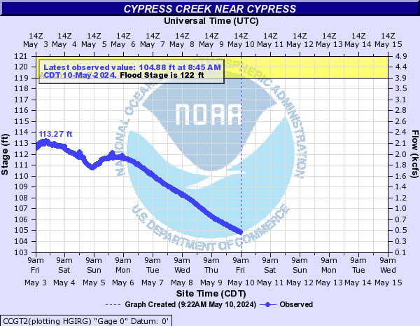
http://www.srh.noaa.gov/wgrfc/ and http://water.weather.gov/ahps2/hydrogra ... gage=CCGT2
-
tireman4

- Global Moderator

- Posts: 6747
- Joined: Wed Feb 03, 2010 9:24 pm
- Location: Humble, Texas
- Contact:
From Houston Community College:
All HCC campuses are closed today due to the weather conditions in Houston @HCCDistrict
All HCC campuses are closed today due to the weather conditions in Houston @HCCDistrict
-
unome
- Posts: 3062
- Joined: Fri Feb 12, 2010 6:11 pm
https://twitter.com/hfdincidents
Unofficial Twittercast of active Houston Fire Department non-EMS incidents
Unofficial Twittercast of active Houston Fire Department non-EMS incidents
-
srainhoutx
- Site Admin
- Posts: 19699
- Joined: Tue Feb 02, 2010 2:32 pm
- Location: Maggie Valley, NC
- Contact:
Carla/Alicia/Jerry(In The Eye)/Michelle/Charley/Ivan/Dennis/Katrina/Rita/Wilma/Humberto/Ike/Harvey
Member: National Weather Association
Facebook.com/Weather Infinity
Twitter @WeatherInfinity
Member: National Weather Association
Facebook.com/Weather Infinity
Twitter @WeatherInfinity
-
unome
- Posts: 3062
- Joined: Fri Feb 12, 2010 6:11 pm
CIMSS Blog: http://cimss.ssec.wisc.edu/goes/blog/archives/18515
Youtube video: https://youtu.be/i47yfoAEnJ0
GOES-14 remained in Super Rapid Scan Operations for GOES-R (SRSO-R) mode on 25 May 2015, providing 1-minute 0.6 µm visible channel imagery of severe thunderstorms that produced widespread damaging winds, hail, and tornadoes across much of Texas
Youtube video: https://youtu.be/i47yfoAEnJ0
GOES-14 remained in Super Rapid Scan Operations for GOES-R (SRSO-R) mode on 25 May 2015, providing 1-minute 0.6 µm visible channel imagery of severe thunderstorms that produced widespread damaging winds, hail, and tornadoes across much of Texas
-
srainhoutx
- Site Admin
- Posts: 19699
- Joined: Tue Feb 02, 2010 2:32 pm
- Location: Maggie Valley, NC
- Contact:
Morning Update from Jeff
Overnight rainfall 8-11 inches over Fort Bend and Harris Counties.
Widespread flooding in in progress…even in areas that do not normally flood. Several bayous have exceeded their banks with rainfall rates of 8.3 inches recorded in 3-hr (over 100-yr rate).
Numerous major freeways are closed and many vehicles are stranded in high water on freeways and secondary roads.
Brays Bayou: worst flooding since 1983
Keegans Bayou: record flood crest has occurred….near 500-yr level
Buffalo Bayou: over 7 ft overbanks in Downtown Houston
37 Texas counties have been declared disaster areas and a declaration for Harris County will be sent to the Governor’s office this morning.
Residents should remain at their current location. Do NOT travel at this time until the flood waters recede.
Carla/Alicia/Jerry(In The Eye)/Michelle/Charley/Ivan/Dennis/Katrina/Rita/Wilma/Humberto/Ike/Harvey
Member: National Weather Association
Facebook.com/Weather Infinity
Twitter @WeatherInfinity
Member: National Weather Association
Facebook.com/Weather Infinity
Twitter @WeatherInfinity
-
TxLady

- Posts: 110
- Joined: Thu Feb 04, 2010 8:39 am
- Location: New Waverly, Walker Co., TX
- Contact:
I know everyone is worn out from last night, and this morning's flooding, but what can we expect for the rest of the day/week? There has been some talk of a possible hurricane impacting the Western Coast of Mexico and eventually making our lives miserable at the end of the week. Is that still a possibility? Thanks for all the very useful information!
-
srainhoutx
- Site Admin
- Posts: 19699
- Joined: Tue Feb 02, 2010 2:32 pm
- Location: Maggie Valley, NC
- Contact:
TxLady wrote:I know everyone is worn out from last night, and this morning's flooding, but what can we expect for the rest of the day/week? There has been some talk of a possible hurricane impacting the Western Coast of Mexico and eventually making our lives miserable at the end of the week. Is that still a possibility? Thanks for all the very useful information!
Right now it looks like just scattered heat of the day showers and storms until around Thursday when another Western upper air disturbance begins to influence our weather and increase our rain chances. Regarding that potential Eastern Pacific Tropic disturbance, it is just beginning to organize several hundred miles West of Mexico and its strength and eventual track toward the Southern Baja Peninsula is highly uncertain and would likely be weakening if it did approach Cabo San Lucas due to cool sea surface temperatures in that part of the Pacific. We will update developments in the Eastern Pacific in our Hurricane Central area of the forum.
Carla/Alicia/Jerry(In The Eye)/Michelle/Charley/Ivan/Dennis/Katrina/Rita/Wilma/Humberto/Ike/Harvey
Member: National Weather Association
Facebook.com/Weather Infinity
Twitter @WeatherInfinity
Member: National Weather Association
Facebook.com/Weather Infinity
Twitter @WeatherInfinity
-
srainhoutx
- Site Admin
- Posts: 19699
- Joined: Tue Feb 02, 2010 2:32 pm
- Location: Maggie Valley, NC
- Contact:
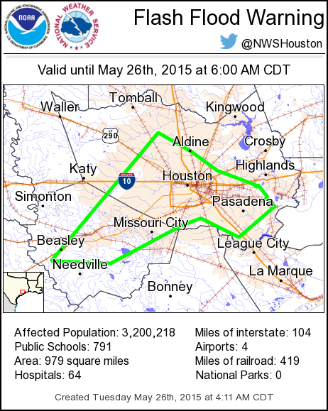
BULLETIN - IMMEDIATE BROADCAST REQUESTED
FLOOD WARNING
NATIONAL WEATHER SERVICE HOUSTON/GALVESTON TX
842 AM CDT TUE MAY 26 2015
HARRIS TX-FORT BEND TX-
842 AM CDT TUE MAY 26 2015
THE NATIONAL WEATHER SERVICE IN LEAGUE CITY HAS EXTENDED THE
* FLOOD WARNING FOR...
SOUTHEASTERN HARRIS COUNTY IN SOUTHEASTERN TEXAS...
CENTRAL FORT BEND COUNTY IN SOUTHEASTERN TEXAS...
* UNTIL 245 PM CDT TUESDAY
* AT 836 AM CDT...STREET...BAYOU AND CREEK FLOODING IS ONGOING FROM
TORRENTIAL RAINFALL OVERNIGHT. HIGH WATER WILL TAKE SEVERAL HOURS
TO RECEDE. DO NOT DRIVE INTO FLOODED ROADS. YOU RISK YOUR LIFE AS
WELL AS FIRST RESPONDERS IF YOU DO SO.
* SOME LOCATIONS THAT WILL EXPERIENCE FLOODING INCLUDE...
PASADENA...SUGAR LAND...NORTHERN BAYTOWN...MISSOURI CITY...NORTHERN
FRIENDSWOOD...DEER PARK...ROSENBERG...STAFFORD...SOUTH HOUSTON...
BELLAIRE...WEST UNIVERSITY PLACE...RICHMOND...GALENA PARK...JACINTO
CITY...JERSEY VILLAGE...HUNTERS CREEK VILLAGE...BUNKER HILL
VILLAGE...PINEY POINT VILLAGE...ASTRODOME AREA AND SPRING VALLEY.
Carla/Alicia/Jerry(In The Eye)/Michelle/Charley/Ivan/Dennis/Katrina/Rita/Wilma/Humberto/Ike/Harvey
Member: National Weather Association
Facebook.com/Weather Infinity
Twitter @WeatherInfinity
Member: National Weather Association
Facebook.com/Weather Infinity
Twitter @WeatherInfinity
-
srainhoutx
- Site Admin
- Posts: 19699
- Joined: Tue Feb 02, 2010 2:32 pm
- Location: Maggie Valley, NC
- Contact:
9;00 AM Update from Jeff:
Flood water is starting to recede however many locations remain flooded especially along Brays Bayou.
Overbanks Flooding:
Brays Bayou
Keegans Bayou
Cypress Creek
Lower White Oak Bayou
Buffalo Bayou (inside 610 loop)
Halls Bayou
South Mayde Creek
West Fork of San Jacinto River
Willow Water Hole
Clear Creek
Armand Bayou
Most channels have crested and are starting to recede. It will take time for the water to go down.
Two flood fatalities have been reported in Harris County thus far.
Widespread house flooding has occurred especially along Brays and Keegans Bayou and other watersheds
Carla/Alicia/Jerry(In The Eye)/Michelle/Charley/Ivan/Dennis/Katrina/Rita/Wilma/Humberto/Ike/Harvey
Member: National Weather Association
Facebook.com/Weather Infinity
Twitter @WeatherInfinity
Member: National Weather Association
Facebook.com/Weather Infinity
Twitter @WeatherInfinity
-
ticka1
- Posts: 1265
- Joined: Wed Feb 03, 2010 3:02 pm
- Location: Baytown/Mont Belvieu
- Contact:
just a few comments
first thank you Khou TV -gannett for this forun aling with srainhoutx, all the membes who posted updates and moderators - yall gave great info for another weather event.
thanks to jeff lindner -this guy is a machine during weather events always therebwith up to date infoan keeps us safe
and one last observation - I hate to think what would happen if we get a real tropical storm impacting this area this season - how bad will we flood.
-
wxman57

- Global Moderator
- Posts: 2621
- Joined: Thu Feb 04, 2010 5:34 am
- Location: Southwest Houston (Westbury)
- Contact:
Had a lot of rain last night in SW Houston. I measured 8.85" at my house. Street flooding but we're far enough from Brays Bayou so as to have no flood threat from it. Couldn't make it to work (by Hobby Apt) until 10am, as Hillcroft was flooded north and south of me as was W. Belfort (east/west).
Can we have a little DRY weather now?
Can we have a little DRY weather now?