June 2025

General Weather Discussions and Analysis
Post Reply
User avatar
DoctorMu
Posts: 7149
Joined: Sun Jun 28, 2015 11:58 am
Location: College Station
Contact:

don wrote: Sat Jun 07, 2025 12:49 pm Wow! They issued a Moderate Risk here tomorrow! 😮 A Derecho is looking likely with 80-100 mph winds possible per SPC. Time to get the batteries charged up. LOL
In other words, the usual! This is a remarkably sustained severe season in the same general areas (SW) of tornado alley.

And a derecho not in the Midwest. The Derecho may head through the DFW area tonight. :shock:
Stratton20
Posts: 5419
Joined: Tue Feb 09, 2021 11:35 pm
Location: College Station, Texas
Contact:

Yeah im seeing big talk about deracho potential in north texas, hope that doesn’t come to pass
User avatar
tireman4
Global Moderator
Global Moderator
Posts: 6211
Joined: Wed Feb 03, 2010 9:24 pm
Location: Humble, Texas
Contact:

Today's Outlook
Attachments
small3.png
small3.png (275.73 KiB) Viewed 932 times
small2.png
small2.png (274.16 KiB) Viewed 932 times
small1.png
small1.png (324.45 KiB) Viewed 932 times
User avatar
don
Posts: 3090
Joined: Wed Feb 03, 2010 3:33 pm
Location: Wichita Falls
Contact:

Getting ready for a severe weather outbreak tonight. Winds of 80-100 mph are possible from the potential Derecho. I'm also under a flood watch.Interesting night ahead lol.
Attachments
xxc4.png
xxc4.png (1.08 MiB) Viewed 847 times
xx2.png
xx2.png (1.38 MiB) Viewed 847 times
Cpv17
Posts: 6606
Joined: Fri Aug 31, 2018 1:58 pm
Location: El Campo/Wharton
Contact:

don wrote: Sun Jun 08, 2025 1:50 pm Getting ready for a severe weather outbreak tonight. Winds of 80-100 mph are possible from the potential Derecho. I'm also under a flood watch.Interesting night ahead lol.
Awesome!
User avatar
Rip76
Posts: 2020
Joined: Mon Feb 15, 2010 12:38 am
Location: The Woodlands
Contact:

tireman4 wrote: Sun Jun 08, 2025 7:05 am Today's Outlook
yay
User avatar
don
Posts: 3090
Joined: Wed Feb 03, 2010 3:33 pm
Location: Wichita Falls
Contact:

A PDS severe thunderstorm watch was issued here.👀
Attachments
Cwwwapture.PNG
Cwwwapture.PNG (259.6 KiB) Viewed 794 times
User avatar
Rip76
Posts: 2020
Joined: Mon Feb 15, 2010 12:38 am
Location: The Woodlands
Contact:

Wondering if this complex of storms may make it to the Houston area tonight.
User avatar
DoctorMu
Posts: 7149
Joined: Sun Jun 28, 2015 11:58 am
Location: College Station
Contact:

No sure.

It *may* make it to B/CS. Seems to be sliding east, though. For now.

Image
869MB
Posts: 197
Joined: Fri Oct 30, 2015 8:44 am
Location: Katy, TX
Contact:

IMG_0162.png
IMG_0162.png (655.75 KiB) Viewed 689 times
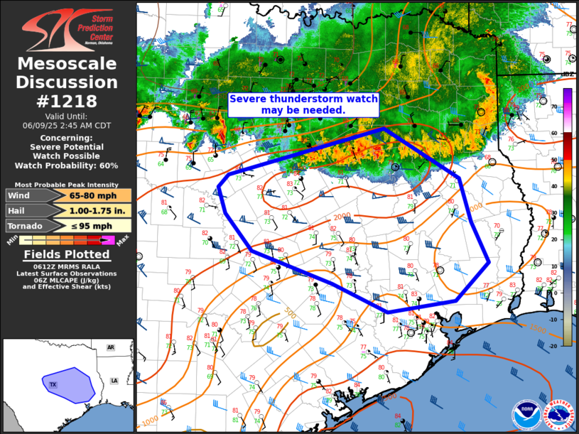
Mesoscale Discussion 1218
NWS Storm Prediction Center Norman OK
0114 AM CDT Mon Jun 09 2025

Areas affected...parts of east-central/southeast Texas

Concerning...Severe potential...Watch possible

Valid 090614Z - 090745Z

Probability of Watch Issuance...60 percent

SUMMARY...A severe thunderstorm watch may be needed south of watch
399.

DISCUSSION...A southward moving line of storms from northeast Texas
to north-central Texas will pose some severe weather threat through
the early morning hours Monday. 2000 to 3000 J/kg MUCAPE and 40
knots of effective shear should provide sufficient
instability/organization for this line of storms to persist through
the morning. The line is broken across central Texas with some more
organized segments southeast of Dallas and more supercellular
structure southwest of Fort Worth. Some guidance, such as the HRRR,
suggests that these supercells across central Texas may congeal into
a cluster and move southeast toward College Station. If this occurs,
a greater severe weather threat may materialize across east-central
Texas. However, if the storms remain somewhat spaced and well behind
the gust front, a more organized severe wind threat seems more
uncertain.

Trends will be monitored and a downstream severe thunderstorm watch
may be needed.

..Bentley/Hart.. 06/09/2025
User avatar
tireman4
Global Moderator
Global Moderator
Posts: 6211
Joined: Wed Feb 03, 2010 9:24 pm
Location: Humble, Texas
Contact:

Be ware of this mornings activity.
Attachments
KHGX_loop.gif
KHGX_loop.gif (730.55 KiB) Viewed 652 times
hgx.png
hgx.png (41.67 KiB) Viewed 652 times
8.png
8.png (746.49 KiB) Viewed 652 times
JDsGN
Posts: 165
Joined: Tue May 23, 2017 10:25 pm
Location: Cypress TX
Contact:

Man that main thrust really fell apart as it hit Austin County. Even still we got 1.3" this morning in Fairfield section of Cypress with 2"+ rainfall rates from 6:20 to 7ish at times. Thats almost as much as models were showing me get for the whole week. Nice start.
User avatar
jasons2k
Posts: 5922
Joined: Thu Feb 04, 2010 12:54 pm
Location: Imperial Oaks
Contact:

Almost an inch here. Great pattern for summer.
User avatar
Rip76
Posts: 2020
Joined: Mon Feb 15, 2010 12:38 am
Location: The Woodlands
Contact:

Any way this “front,” stalls in the gulf?
User avatar
Rip76
Posts: 2020
Joined: Mon Feb 15, 2010 12:38 am
Location: The Woodlands
Contact:

Rip76 wrote: Mon Jun 09, 2025 9:56 am Any way this “front,” stalls in the gulf?
Eh, doesn't look like there's a lot left of this.
MH5
Posts: 61
Joined: Mon Jun 22, 2020 2:20 pm
Location: The Heights
Contact:

Slight risk has been expanded to include the metro and parts east for this evening. CAMs have all suggested that redevelopment is possible right over central Harris Co with all this daytime heating around rush hour. Keep an eye out.

Image
User avatar
tireman4
Global Moderator
Global Moderator
Posts: 6211
Joined: Wed Feb 03, 2010 9:24 pm
Location: Humble, Texas
Contact:

Heads up for later today
Attachments
FB_IMG_1749497169959.jpg
FB_IMG_1749497169959.jpg (122.73 KiB) Viewed 393 times
User avatar
don
Posts: 3090
Joined: Wed Feb 03, 2010 3:33 pm
Location: Wichita Falls
Contact:

Harris County is the severe thunderstorm “capital” of SE Texas. It is a favored spot for frontal and mesoscale boundaries to setup.I think Galveston Bay and the heat island plays a role…
User avatar
don
Posts: 3090
Joined: Wed Feb 03, 2010 3:33 pm
Location: Wichita Falls
Contact:

Fun fact the #1 county in Texas for severe thunderstorm warnings is Pecos County where Ft Stockton is located. Due to a semi permanent supercell that develops frequently in the Spring from the topography of the region. This supercell sometimes goes by the name “Old Faithful”. 😀
User avatar
tireman4
Global Moderator
Global Moderator
Posts: 6211
Joined: Wed Feb 03, 2010 9:24 pm
Location: Humble, Texas
Contact:

Might be a harbinger of things to come
Attachments
KHGX_loop-1.gif
KHGX_loop-1.gif (274.63 KiB) Viewed 239 times
Post Reply
  • Information