Page 5 of 16
Re: March 2010- In Like A Lamb, Out Like A Lion?
Posted: Wed Mar 03, 2010 10:50 am
by srainhoutx
Paul wrote:
we are in March...El Nino fading...sun angle higher...snow pack shrinking....IMO, winter is OVER!!
Although no wintry weather for us. The GFS has been rather persistent on some 'cooler'/wet weather near the middle of March...

Re: March 2010- In Like A Lamb, Out Like A Lion?
Posted: Wed Mar 03, 2010 10:53 am
by wxman57
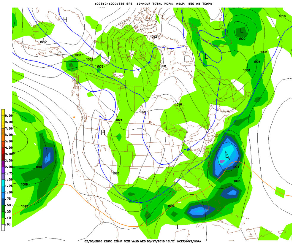
Still bad news on the 80F front. Latest GFS keeps us cold through 15 days:
Remember on March 4, 2002 IAH hit 22F. That's almost the coldest ever recorded in March. Houston hit 21F on March 3, 1943.


Re: March 2010- In Like A Lamb, Out Like A Lion?
Posted: Wed Mar 03, 2010 11:36 am
by biggerbyte
Winter season ends, but we can usually count on more cold weather around Easter. It has been like that here in Texas since I can remember, and I see nothing that would prevent that this year. Let's get past that before calling it done???

Re: March 2010- In Like A Lamb, Out Like A Lion?
Posted: Wed Mar 03, 2010 11:54 am
by wxman57
biggerbyte wrote:Winter season ends, but we can usually count on more cold weather around Easter. It has been like that here in Texas since I can remember, and I see nothing that would prevent that this year. Let's get past that before calling it done???
Winter over? Ha! I certainly wouldn't say that. GFS temperature forecast is for colder after March 15th. I expect that April, too, will turn out 3-5F below normal. We'll continue to see cold fronts through early May, at least. However, our chances of any additional winter precipitation are remote.
Re: March 2010- In Like A Lamb, Out Like A Lion?
Posted: Wed Mar 03, 2010 12:59 pm
by biggerbyte
wxman57 wrote:biggerbyte wrote:Winter season ends, but we can usually count on more cold weather around Easter. It has been like that here in Texas since I can remember, and I see nothing that would prevent that this year. Let's get past that before calling it done???
Winter over? Ha! I certainly wouldn't say that. GFS temperature forecast is for colder after March 15th. I expect that April, too, will turn out 3-5F below normal. We'll continue to see cold fronts through early May, at least. However, our chances of any additional winter precipitation are remote.
Agreed! But didn't I say that already? Lol
Your reply must have been meant for someone else.
Anyway, folks we are not done with cold weather, no matter when Spring has sprung. Speaking of which, my yard is showing signs of now.
Re: March 2010- In Like A Lamb, Out Like A Lion?
Posted: Wed Mar 03, 2010 1:41 pm
by jasonhoutx
ugggh......This winter is getting old. I am craving warmth.
Guess this year will be no record breaker for heat.
Re: March 2010- In Like A Lamb, Out Like A Lion?
Posted: Wed Mar 03, 2010 11:34 pm
by Paul
srainhoutx wrote:Paul wrote:
we are in March...El Nino fading...sun angle higher...snow pack shrinking....IMO, winter is OVER!!
Although no wintry weather for us. The GFS has been rather persistent on some 'cooler'/wet weather near the middle of March...
I got up into the mid-60's today....March 15 is la la land.....I doubt we will see cold fronts into May also. JMO.....
Re: March 2010- In Like A Lamb, Out Like A Lion?
Posted: Thu Mar 04, 2010 7:57 am
by wxman57
Don't be so sure the fronts won't continue into May. It's a rare May that we DON'T get a cold front through, in fact. Had a strong front pass Houston last May 16th and a weak front in early June last year. See the Houston climo from last year here:
http://www.weather.gov/climate/index.php?wfo=hgx
Note the 1055mb high the GFS has building in western Canada now. The GFS is quite cool for mid March, but the Euro is even colder. Here's the 06Z GFS forecast for temps/precip the next 15 days:


And here's the Euro 500mb pattern and 850mb temps for next week. Quite a cold pattern.

Re: March 2010- In Like A Lamb, Out Like A Lion?
Posted: Thu Mar 04, 2010 8:47 am
by Katdaddy
Ready to enjoy the sunny warm weather the next few days. Its about time!!
Re: March 2010- In Like A Lamb, Out Like A Lion?
Posted: Thu Mar 04, 2010 10:48 am
by sleetstorm
I know that some of us on this weather forum are very much looking forward to the season of Spring & warmer temperatures which I am too. I think that we need to enjoy the last cool and cold days and nights during the last of these winter days and however many that the season of Spring does happen to have in them this year because come summer time some of us are going to wish that they were much much cooler.
Re: March 2010- In Like A Lamb, Out Like A Lion?
Posted: Thu Mar 04, 2010 10:51 am
by wxman57
12Z GFS is in. No hope of spring next 2 weeks. GFS is beginning to agree more with the ECMWF on an extended cold period after the 15th, but it isn't
NEARLY[/b] as cold as the Euro for that period.
I'd be perfectly happy if the temperatures never dropped below 60F for lows, sleetstorm. A tropical island near the Equator would have perfect weather for me. 90F? 100F? No big deal. Bring it on. I'll even go for long bike rides in the heat. Can't recall every wishing for cool weather in July...


Re: March 2010- In Like A Lamb, Out Like A Lion?
Posted: Thu Mar 04, 2010 11:30 am
by wxdata
But, and this is a big but (tempted to hotlink an image but won't), if we can get some moisture return, Monday could be a fun-derstorm day.
Main action on Monday may stay a little north.
SPC-
"THUNDERSTORMS WOULD BEGIN THE SRN HIGH PLAINS SATURDAY
NIGHT SPREADING EWD AND INCREASING IN COVERAGE ACROSS THE SRN PLAINS
BY SUNDAY AFTERNOON. AT THIS TIME...THE MODELS ARE FORECASTING
LIMITED MOISTURE RETURN UNTIL SUNDAY NIGHT WHEN SFC DEWPOINTS MAY
REACH THE LOWER 60S F ACROSS PARTS OF EAST TX.
THIS WOULD BE THE
MOST LIKELY TIME FOR A SEVERE THREAT ESPECIALLY IF A SQUALL-LINE CAN
ORGANIZE IN NORTH TX AND MOVE EWD ACROSS THE ARKLATEX DURING THE DAY
ON MONDAY/DAY 5."
Further down the road, some disagreement between the 0z GFS and 0z ECMWF for the middle of next week. ECMWF shows a nice upper system moving across Texas, while the GFS show a much weaker system. The beige color is the Euro, while the gray is the GFS. Click to enlarge
Re: March 2010- In Like A Lamb, Out Like A Lion?
Posted: Thu Mar 04, 2010 5:56 pm
by srainhoutx
Keep an eye on Mid March. I suspect a change is coming...
Interesting article...
http://www.jondavies.net/041005nwks/041005nwks.htm
Re: March 2010- In Like A Lamb, Out Like A Lion?
Posted: Thu Mar 04, 2010 9:35 pm
by sambucol
What kind of change, srainhoutx? Is it going to get cold one more time here before spring sets in?
Re: March 2010- In Like A Lamb, Out Like A Lion?
Posted: Thu Mar 04, 2010 11:03 pm
by C2G
Can't wait to see a few of these around.

Re: March 2010- In Like A Lamb, Out Like A Lion?
Posted: Thu Mar 04, 2010 11:37 pm
by wxdata
GFS has come around to the thinking of the ECMWF about the strong upper system crossing Texas the middle part of next week. May be interesting for some in Texas next week.
Re: March 2010- In Like A Lamb, Out Like A Lion?
Posted: Fri Mar 05, 2010 7:55 am
by wxman57
Yeah, looks like we've moved out of "winter weather mode" and are moving into "severe weather mode" across Texas. The active southern storm track all winter may translate into an active severe storm season across the Southern Plains this spring.
Re: March 2010- In Like A Lamb, Out Like A Lion?
Posted: Fri Mar 05, 2010 8:13 am
by svrwx0503
Yeah, the system forecast by the models to be moving into the region by the middle of next week could possibly pack quite a punch for someone in the state. The upper level dynamics look impressive with a strong s/w cutting down into central Texas along with at least part (northern) of our region falling in the left exit region of a currently (00z and 06z GFS) forecast 150kt+ jet streak. This would lead to plenty of lift across the area, the only problem could be a lack of instability due to cloud cover and possibly the amount of quality moisture return due to Monday/Tuesday's system possibly scouring out some of the moisture. Also a lack of a real pronounced low level jet ahead of Wednesday's storm until it moves to our east could keep moisture levels a tad bit low for real strong thunderstorm development. So the severe threat is still questionable but another round of showers and possibly some storms does look like a good bet Wednesday afternoon and evening with the strongest storms possibly up to the northeast (something we see a lot during the early spring months).
Re: March 2010- In Like A Lamb, Out Like A Lion?
Posted: Fri Mar 05, 2010 11:21 am
by biggerbyte
wxman57 wrote:Yeah, looks like we've moved out of "winter weather mode" and are moving into "severe weather mode" across Texas. The active southern storm track all winter may translate into an active severe storm season across the Southern Plains this spring.
I'm confused, Wxman. I too am curious how your official stance is on the rest of this winter season, comparing to some others. The statement about severe weather seems to be a different position. Can't have severe storms AND cold temps. Splain, Lucy.
.... Copy of our previous conversation...
wxman57 wrote:biggerbyte wrote:Winter season ends, but we can usually count on more cold weather around Easter. It has been like that here in Texas since I can remember, and I see nothing that would prevent that this year. Let's get past that before calling it done???
Winter over? Ha! I certainly wouldn't say that. GFS temperature forecast is for colder after March 15th. I expect that April, too, will turn out 3-5F below normal. We'll continue to see cold fronts through early May, at least. However, our chances of any additional winter precipitation are remote.
Re: March 2010- In Like A Lamb, Out Like A Lion?
Posted: Fri Mar 05, 2010 1:10 pm
by TexasMetBlake
biggerbyte wrote:wxman57 wrote:Yeah, looks like we've moved out of "winter weather mode" and are moving into "severe weather mode" across Texas. The active southern storm track all winter may translate into an active severe storm season across the Southern Plains this spring.
I'm confused, Wxman. I too am curious how your official stance is on the rest of this winter season, comparing to some others. The statement about severe weather seems to be a different position. Can't have severe storms AND cold temps. Splain, Lucy.
.... Copy of our previous conversation...
wxman57 wrote:biggerbyte wrote:Winter season ends, but we can usually count on more cold weather around Easter. It has been like that here in Texas since I can remember, and I see nothing that would prevent that this year. Let's get past that before calling it done???
Winter over? Ha! I certainly wouldn't say that. GFS temperature forecast is for colder after March 15th. I expect that April, too, will turn out 3-5F below normal. We'll continue to see cold fronts through early May, at least. However, our chances of any additional winter precipitation are remote.
Well keep in mind with the sun angle and time of year, "below-average" still translates to WAY TO WARM FOR WINTRY WX here in southeast Texas. With average temps this month SURGING into the mid 70s, below average only translates to temps between 68 and 72. I hardly wouldn't rule out one last freeze at IAH, but for the most part, winter 2009-10 is history. Sniff, now if you'll excuse me, I'm going into mourning. Sniff.