Page 49 of 55
Re: JUNE 2015 -Tracking Tropical Depression Bill
Posted: Thu Jun 18, 2015 2:27 pm
by srainhoutx
BULLETIN - IMMEDIATE BROADCAST REQUESTED
FLOOD WARNING
NATIONAL WEATHER SERVICE HOUSTON/GALVESTON, TX
220 PM CDT THU JUN 18 2015
...The National Weather Service in Houston/Galveston has issued a flood warning
for the following rivers...
Cypress Creek Near Katy-Hockley Road affecting the following counties in
Texas...Harris...Waller
Bands of heavy rain associated with Tropical Storm Bill has produced 2 to 3
inches of rain with isolated areas of 4 to 5 inches over the upper Cypress Creek
watershed. Runoff from this rainfall is expected to produce minor flooding near
Katy-Hockley Road.
Re: JUNE 2015 -Tracking Tropical Depression Bill
Posted: Thu Jun 18, 2015 2:47 pm
by Ounce
The gift that keeps on giving.
Re: JUNE 2015 -Tracking Tropical Depression Bill
Posted: Thu Jun 18, 2015 2:50 pm
by nuby3
Ounce wrote:The gift that keeps on giving.
those cells North of Victoria seem completely determined to get into Grimes county. lol
sea breeze activity maybe?
Re: JUNE 2015 -Tracking Tropical Depression Bill
Posted: Thu Jun 18, 2015 2:52 pm
by davidiowx
Crazy how all of the rain has been N, S, E and W of Fort Bend county lol
Re: JUNE 2015 -Tracking Tropical Depression Bill
Posted: Thu Jun 18, 2015 3:05 pm
by Ounce
nuby3 wrote:Ounce wrote:The gift that keeps on giving.
those cells North of Victoria seem completely determined to get into Grimes county. lol
With 59 closed south of El Campo, I would like to have one or two other options not under water so I can drive back to Houston from Corpus, tomorrow. I have the options planned out. But I'd hate to have to take I-37 to SA to pick up 10.
Re: JUNE 2015 -Tracking Tropical Depression Bill
Posted: Thu Jun 18, 2015 3:48 pm
by srainhoutx
FLOOD STATEMENT
NATIONAL WEATHER SERVICE HOUSTON/GALVESTON TX
341 PM CDT THU JUN 18 2015
HOUSTON TX-TRINITY TX-MADISON TX-WALKER TX-SAN JACINTO TX-
MONTGOMERY TX-GRIMES TX-
341 PM CDT THU JUN 18 2015
...THE FLOOD WARNING FOR URBAN AREAS AND SMALL STREAMS HAS EXPIRED
FOR HOUSTON...TRINITY...EASTERN MADISON...WALKER...NORTHWESTERN SAN
JACINTO...NORTHWESTERN MONTGOMERY AND GRIMES COUNTIES...
HEAVY RAINFALL HAS ENDED ACROSS THE WARNED AREA. EVEN THOUGH LIGHT
TO MODERATE RAINS WILL COME TO AN END LATER THIS AFTERNOON...MANY
AREA ROADS THAT HAVE ALREADY FLOODED COULD REMAIN IMPASSABLE AND
CLOSED THROUGHOUT THE NIGHT BEFORE CREEK AND RIVER LEVELS DROP
ENOUGH TO ALLOW WATER LEVELS TO RECEDE FROM THE ROADWAY. AT 330 PM
CDT...EMERGENCY MANAGEMENT AND LAW ENFORCEMENT OFFICIALS IN WALKER
AND TRINITY COUNTIES REPORTED MANY ROADS IMPASSABLE ACROSS PARTS OF
THE AREA. EVEN WITH LITTLE OR NO RAIN...WATER LEVELS MIGHT NOT
RECEDE UNTIL SOME TIME ON FRIDAY MORNING.
DO NOT DRIVE YOUR VEHICLE INTO AREAS WHERE THE WATER COVERS THE
ROADWAY. THE WATER DEPTH MAY BE TOO GREAT TO ALLOW YOUR CAR TO CROSS
SAFELY. MOVE TO HIGHER GROUND. TURN AROUND...DONT DROWN.
Re: JUNE 2015 -Tracking Tropical Depression Bill
Posted: Thu Jun 18, 2015 4:11 pm
by Ounce
Looks like the flow from across the border at Brownsville has stopped. And it looks like the blob from Kingsville to Cuero is raining itself out, too.
Re: JUNE 2015 -Tracking Tropical Depression Bill
Posted: Thu Jun 18, 2015 4:29 pm
by brooksgarner
Gravity Waves?
If you look at the water vapor loop of that MCS interacting with "Bill", you may also notice the gravity wave racing southward "thru" the tropical depression -- seemingly able to propagate as if it's a low frequency radio wave, penetrating every cloud on its journey southward until its finally absorbed into the ridge to the south. So my question of the evening when it comes to "unexpected" forecast features overnight: Will that wave make it SE TX and trigger the tropical moisture to produce "surprise" overnight storms -- something that the models aren't picking up on? (Eye balling it, if it holds together, it wouldn't arrive until after 2am...)
Re: JUNE 2015 -Tracking Tropical Depression Bill
Posted: Thu Jun 18, 2015 4:57 pm
by TexasBreeze
I took a look at the satellite loops of the central U.S. and that is a really neat observation of that wave going right through the low pressure system of Bill! Interesting!
Re: JUNE 2015 -Tracking Tropical Depression Bill
Posted: Thu Jun 18, 2015 5:03 pm
by brooksgarner
TexasBreeze wrote:I took a look at the satellite loops of the central U.S. and that is a really neat observation of that wave going right through the low pressure system of Bill! Interesting!
Check out on my Facebook page (link below), the gravity waves originating from Cuba and traveling "against the grain" and free from influence, straight to the Yucatan, where they induced afternoon storms. Fascinating feature. They are pure, low frequency energy.
Re: JUNE 2015 -Tracking Tropical Depression Bill
Posted: Thu Jun 18, 2015 5:08 pm
by unome
brooksgarner wrote:Gravity Waves?
If you look at the water vapor loop of that MCS interacting with "Bill", you may also notice the gravity wave racing southward "thru" the tropical depression -- seemingly able to propagate as if it's a low frequency radio wave, penetrating every cloud on its journey southward until its finally absorbed into the ridge to the south. So my question of the evening when it comes to "unexpected" forecast features overnight: Will that wave make it SE TX and trigger the tropical moisture to produce "surprise" overnight storms -- something that the models aren't picking up on? (Eye balling it, if it holds together, it wouldn't arrive until after 2am...)
something's going to collide with the msc coming down from central tx
http://weather.cod.edu/satrad/nexrad/in ... K-N0Q-1-48
Re: JUNE 2015 -Tracking Tropical Depression Bill
Posted: Thu Jun 18, 2015 5:15 pm
by Ounce
brooksgarner wrote:TexasBreeze wrote:I took a look at the satellite loops of the central U.S. and that is a really neat observation of that wave going right through the low pressure system of Bill! Interesting!
Check out on my Facebook page (link below), the gravity waves originating from Cuba and traveling "against the grain" and free from influence, straight to the Yucatan, where they induced afternoon storms. Fascinating feature. They are pure, low frequency energy.
As if the wave can go through walls, like a ghost. Is there a kryptonite or a speed bump to hinder its travel?
Re: JUNE 2015 -Tracking Tropical Depression Bill
Posted: Thu Jun 18, 2015 5:17 pm
by unome
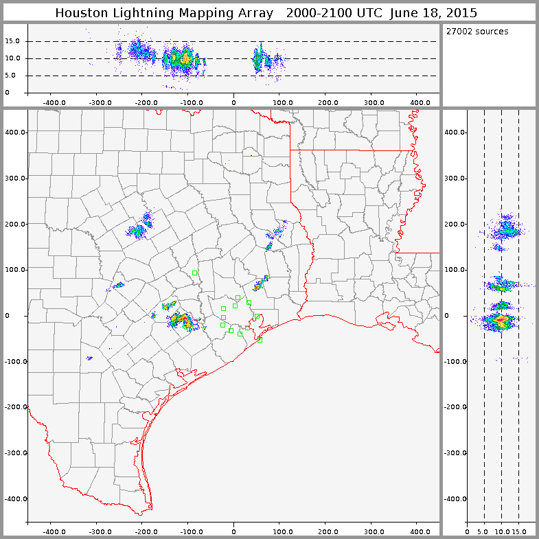
the central tx storm literally "stole the thunder" from it's southern counterpart

previous hour

Re: JUNE 2015 -Tracking Tropical Depression Bill
Posted: Thu Jun 18, 2015 5:36 pm
by brooksgarner
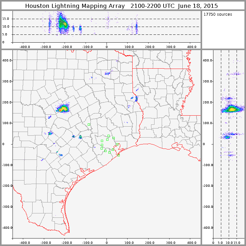
Cool shot of the lightning... yes, to reply to the previous poster, the "ghost" comparison is good. Gravity waves seems to act by their own rules, immune to clouds or atmospheric flow direction in their trek.
Re: JUNE 2015 -Tracking Tropical Depression Bill
Posted: Thu Jun 18, 2015 7:03 pm
by Paul Robison
[quote[]="unome"]
brooksgarner wrote:Gravity Waves?
If you look at the water vapor loop of that MCS interacting with "Bill", you may also notice the gravity wave racing southward "thru" the tropical depression -- seemingly able to propagate as if it's a low frequency radio wave, penetrating every cloud on its journey southward until its finally absorbed into the ridge to the south. So my question of the evening when it comes to "unexpected" forecast features overnight: Will that wave make it SE TX and trigger the tropical moisture to produce "surprise" overnight storms -- something that the models aren't picking up on? (Eye balling it, if it holds together, it wouldn't arrive until after 2am...)
something's going to collide with the msc coming down from central tx
http://weather.cod.edu/satrad/nexrad/in ... K-N0Q-1-48

[/quote]
doesn't look to me like it's holding together. But: would this mean severe weather for the overnight period?
Re: JUNE 2015 -Tracking Tropical Depression Bill
Posted: Thu Jun 18, 2015 8:03 pm
by nuby3
Paul Robison wrote:[quote[]="unome"]
brooksgarner wrote:Gravity Waves?
If you look at the water vapor loop of that MCS interacting with "Bill", you may also notice the gravity wave racing southward "thru" the tropical depression -- seemingly able to propagate as if it's a low frequency radio wave, penetrating every cloud on its journey southward until its finally absorbed into the ridge to the south. So my question of the evening when it comes to "unexpected" forecast features overnight: Will that wave make it SE TX and trigger the tropical moisture to produce "surprise" overnight storms -- something that the models aren't picking up on? (Eye balling it, if it holds together, it wouldn't arrive until after 2am...)
something's going to collide with the msc coming down from central tx
http://weather.cod.edu/satrad/nexrad/in ... K-N0Q-1-48

doesn't look to me like it's holding together. But: would this mean severe weather for the overnight period?[/quote]
I don't think that's what Brooks meant, and what collided with that MCS was an outflow boundary I believe. I still haven't seen the gravity wave Brooks was mentioning but I simply may not know what I'm supposed to be looking for. The MCS in central Texas will not impact our weather
Re: JUNE 2015 -Tracking Tropical Depression Bill
Posted: Thu Jun 18, 2015 8:06 pm
by Paul Robison
Then the worst we'd get from this "gravity wave" (if it affects SE TX at all) is maybe a little shot of heavy rain, nuby3. (Not a question)
Re: JUNE 2015 -Tracking Tropical Depression Bill
Posted: Thu Jun 18, 2015 8:54 pm
by nuby3
Paul Robison wrote:Then the worst we'd get from this "gravity wave" (if it affects SE TX at all) is maybe a little shot of heavy rain, nuby3. (Not a question)
yep, I really don't think there's a high chance of it making an impact, I think he was just making an observation, and posing a hypothesis. if it rains tonight, we'll know why.

but more than likely it's gone until the sun comes back out, and normal scattered afternoon showers resume
Re: JUNE 2015 -Tracking Tropical Depression Bill
Posted: Thu Jun 18, 2015 9:23 pm
by Paul Robison
nuby3 wrote:Paul Robison wrote:Then the worst we'd get from this "gravity wave" (if it affects SE TX at all) is maybe a little shot of heavy rain, nuby3. (Not a question)
yep, I really don't think there's a high chance of it making an impact, I think he was just making an observation, and posing a hypothesis. if it rains tonight, we'll know why.

but more than likely it's gone until the sun comes back out, and normal scattered afternoon showers resume
Back to basics.
Re: JUNE 2015 -Typical Summer Pattern Returns
Posted: Fri Jun 19, 2015 3:26 am
by srainhoutx
A sight for sore eyes for those that have been dealing with flooding, rising rivers and streams and sleepless nights. The San Antonio area is seeing some flooding this morning from the area of thunderstorms that Brooks was mentioning yesterday afternoon and training slow moving thunderstorms have remained almost stationary overnight. The Quantitative Precipitation Forecast for the next week suggests a very typical summer time pattern with heat of the day thunderstorm chances across our Region. The only fly in the ointment will be near the Rio Grande Valley where an inverted trough develops between a building SW United States ridge and the upper ridge across the SE United States. Showers and thunderstorms appear likely throughout the weekend in that area, but drier conditions set up elsewhere.
Rain chances begin to increase by mid next week as a return flow off the Gulf becomes established with a building ridge over the Central United States develops and a rather deep trough organizes to our East. The tropics look quiet across the Atlantic Basin and the Eastern Pacific Basin with no tropical development expected for the next week.


 [/quote]