
April Weather Discussion.


-
srainhoutx

- Site Admin

- Posts: 19616
- Joined: Tue Feb 02, 2010 2:32 pm
- Location: Maggie Valley, NC
- Contact:
Morning e-mail from Jeff confirms as well wxman57.
After another very windy weekend, high pressure has built into the region overnight with strong NW winds relaxing under another below normal morning.
High pressure overhead today and Tuesday will allow for lighter winds and continued below normal temperatures for the last few days of March. Lows back into the 40’s each morning with gradual warming of the highs into the mid 70’s looks reasonable through Wednesday under mostly sunny skies.
All forecast concerns this morning lay in the extended for Friday and Saturday as the next upper level storm system moves toward TX. Upper level pattern change with a developing trough over the SW US versus the east coast will usher in a few days of moist return flow off the Gulf of Mexico…something we have seen little of this spring . Expect surface ridge to move east of the region Wed with southerly winds returning and gradual increasing moisture levels. Dewpoints should reach into the 60’s by late Thursday as 40-50kt low level jet develops from S TX through the coastal bend into N TX. GFS shows dewpoints pushing 65-70 by late Friday as a stout dry line develops over central TX. Strong dynamics come to bear across TX Friday afternoon/night with good wind energy and for what appears to be the first time this spring some decent instability. Expect the dry line to begin to surge eastward Friday afternoon and ignite strong to severe convection over central TX. Wind profiles favor rapid upgrowth into a linear MCS or squall line with favorable profiles for numerous bowing segments. Timing for impacts into SE TX and the coastal bend region look to be after midnight into early Saturday morning. We are still 5-6 days out for this event and much can/will change with regards to convective parameters over the next few days…two important questions will be cap intensity building out of NE Mexico and quality of returning Gulf air mass.
Sytem should be east of the area by Saturday afternoon with dry and mild conditions for next Sunday. For now will disreagrd the GFS solution showing the upper trough cutting off of TX and keeping rain chances into Sunday.
Carla/Alicia/Jerry(In The Eye)/Michelle/Charley/Ivan/Dennis/Katrina/Rita/Wilma/Humberto/Ike/Harvey
Member: National Weather Association
Facebook.com/Weather Infinity
Twitter @WeatherInfinity
Member: National Weather Association
Facebook.com/Weather Infinity
Twitter @WeatherInfinity
-
srainhoutx
- Site Admin
- Posts: 19616
- Joined: Tue Feb 02, 2010 2:32 pm
- Location: Maggie Valley, NC
- Contact:
Looks like areas from just W of San Antonio to Abilene to OKC will be the firing line beginning on Friday afternoon at this time. I noticed that San Angelo, Austin/San Antonio and Ft Worth/Dallas are already mentioning the severe threat. As always, how strong of a cap we have will be the key, but I suspect Friday to be an eventful afternoon and evening for areas E of the dry line. I would not be surprised to see a Slight Risk issued by the SPC in the next couple of days.
Carla/Alicia/Jerry(In The Eye)/Michelle/Charley/Ivan/Dennis/Katrina/Rita/Wilma/Humberto/Ike/Harvey
Member: National Weather Association
Facebook.com/Weather Infinity
Twitter @WeatherInfinity
Member: National Weather Association
Facebook.com/Weather Infinity
Twitter @WeatherInfinity

Ft Worth NWS for North Texas Friday:
FRIDAY LOOKS LIKE A SET UP FOR SEVERE WEATHER...AND I HAVE
INDICATED SEVERE THUNDERSTORMS IN THE GRIDS. THERE WILL BE A
STRONG CAP OVER NORTH TEXAS TO START THE DAY. STRONG LARGE SCALE
FORCING AS THE UPPER LOW APPROACHES WILL ERODE THIS CAP BY LATE
MORNING TO EARLY AFTERNOON. MODERATE CAPE AND FAIRLY STRONG SHEAR
PROFILES SUGGEST A SQUALL LINE DEVELOPING ACROSS THE BIG COUNTRY
AND WESTERN COUNTIES DURING THE AFTERNOON...TRANSITIONING EAST
ACROSS NORTH TEXAS INTO THE OVERNIGHT HOURS. LARGE HAIL AND
DAMAGING WINDS WILL BE THE MAIN THREAT. HODOGRAPHS SHOW GOOD LOW
LEVEL TURNING IN THE WINDS...BUT A TORNADO LIMITING FACTOR MAY BE
WIDESPREAD CLOUD COVER KEEPING LOW LEVEL TEMPERATURES AND THUS
INSTABILITY DOWN. DURING THE EVENT...BREAKS IN CLOUD COVER AND
OTHER MESOSCALE FEATURES WILL BE KEY IN PREDICTING THE EVOLUTION
OF A TORNADO THREAT.
-
sleetstorm
- Posts: 651
- Joined: Thu Feb 04, 2010 12:33 pm
- Contact:
Would Supercell Thunderstorms, Bow Echo Thunderstorms, & Hook Echo Thunderstorms be feasible in SE Texas on 4/3-4/10?
-
srainhoutx
- Site Admin
- Posts: 19616
- Joined: Tue Feb 02, 2010 2:32 pm
- Location: Maggie Valley, NC
- Contact:
Ed Mahmoud wrote:Friday now officially potentially fun (>30%) around Dallas.
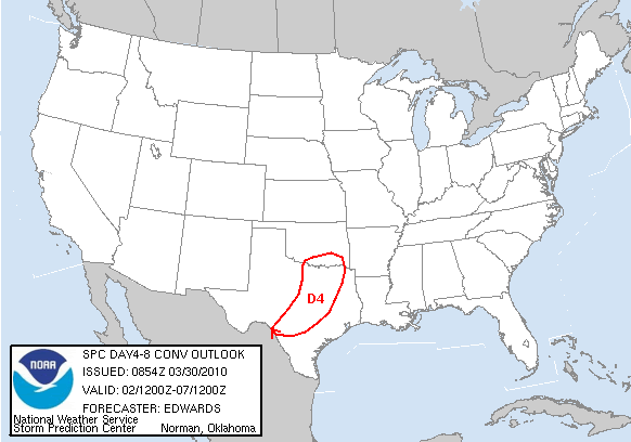
DAY 4-8 CONVECTIVE OUTLOOK
NWS STORM PREDICTION CENTER NORMAN OK
0354 AM CDT TUE MAR 30 2010
VALID 021200Z - 071200Z
...DISCUSSION...
STG WRN TROUGHING IS EXPECTED FROM WY-NM TO NWRN MEX BY START OF
DAY-4/2ND-3RD...WITH CONSENSUS AMONG BOTH ENSEMBLE AND OPERATIONAL
MODELS THAT THIS FEATURE WILL TURN NEWD LATE DAY-4 AND INTO
DAY-5/3RD-4TH...REACHING VICINITY LS BY END OF DAY-5. SFC CYCLONE
LIKEWISE SHOULD EJECT NEWD FROM SRN PLAINS TO UPPER MS VALLEY...AS
COLD FRONT SWEEPS EWD/SEWD OVER MID-UPPER MS VALLEY AND SRN PLAINS.
UKMET APPEARS TO BE LESS-RELIABLE FAST OUTLIER COMPARED TO
ECMWF/SPECTRAL AND MOST MREF MEMBERS. FRONT SHOULD WEAKEN ACROSS S
TX DAYS 5-6/3RD-5TH AS UPPER SUPPORT WILL BE WELL-REMOVED.
GREATEST SVR POTENTIAL APPEARS TO BE DAY-4 INVOF FRONT...BEGINNING
EARLY IN PERIOD OVER WRN PORTIONS SRN PLAINS...WHEN GEOMETRY OF MASS
FIELDS...MAX AVAILABILITY OF MOISTURE TO THIS SYSTEM...AND PROBABLE
ALIGNMENT OF FRONT SUGGEST LIKELIHOOD OF DOMINANT LINEAR
ORGANIZATION. DEEP-LAYER SHEAR CERTAINLY COULD BE SUFFICIENT TO
SUPPORT SUPERCELLS ESPECIALLY NEAR SRN PORTION OF CONVECTIVE ZONE
OVER TX...WHERE CAPPING WILL BE STRONGER DUE TO ANTECEDENT ELEVATED
MIXED LAYER. ACTUAL CORRIDOR OF POTENTIAL SVR THREAT IS LONGER THAN
30% AREA HERE...WHICH INSTEAD REPRESENTS BEST ESTIMATE OF
JUXTAPOSITION OF MOVING FRONTAL ZONE...RICHEST RETURNING MOISTURE
AND STG DEEP-LAYER SHEAR.
..EDWARDS.. 03/30/2010
CLICK TO GET WUUS48 PTSD48 PRODUCT
Carla/Alicia/Jerry(In The Eye)/Michelle/Charley/Ivan/Dennis/Katrina/Rita/Wilma/Humberto/Ike/Harvey
Member: National Weather Association
Facebook.com/Weather Infinity
Twitter @WeatherInfinity
Member: National Weather Association
Facebook.com/Weather Infinity
Twitter @WeatherInfinity

-
srainhoutx
- Site Admin
- Posts: 19616
- Joined: Tue Feb 02, 2010 2:32 pm
- Location: Maggie Valley, NC
- Contact:
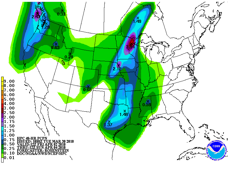
HPC still thinking the heaviest rainfall will be N and W of Houston.
Carla/Alicia/Jerry(In The Eye)/Michelle/Charley/Ivan/Dennis/Katrina/Rita/Wilma/Humberto/Ike/Harvey
Member: National Weather Association
Facebook.com/Weather Infinity
Twitter @WeatherInfinity
Member: National Weather Association
Facebook.com/Weather Infinity
Twitter @WeatherInfinity
-
srainhoutx
- Site Admin
- Posts: 19616
- Joined: Tue Feb 02, 2010 2:32 pm
- Location: Maggie Valley, NC
- Contact:
San Angelo Multi Media briefing offering some hints as to what we may see on Friday in TX...
http://www.srh.noaa.gov/sjt/?n=daily
http://www.srh.noaa.gov/sjt/?n=daily
Carla/Alicia/Jerry(In The Eye)/Michelle/Charley/Ivan/Dennis/Katrina/Rita/Wilma/Humberto/Ike/Harvey
Member: National Weather Association
Facebook.com/Weather Infinity
Twitter @WeatherInfinity
Member: National Weather Association
Facebook.com/Weather Infinity
Twitter @WeatherInfinity
-
sleetstorm
- Posts: 651
- Joined: Thu Feb 04, 2010 12:33 pm
- Contact:
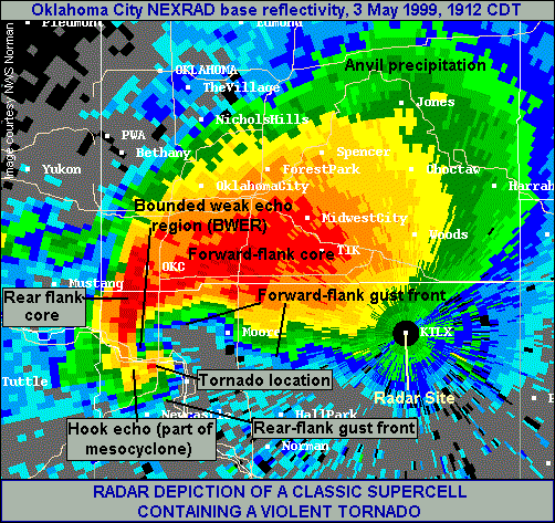
No, Ed Mahmoud, I honestly did not know that a Hook Echo was a very good indication of strong low level shear. I have for a very long time sensed that had something to do with the way that it forms and why it forms and how strong that it could become.Ed Mahmoud wrote:You know a "hook echo" is something that develops on a supercell, and is usually a very good indication of strong low level rotation, right?
Interweb search on "Oklahoma City 1999 hook echo brings up this Wiki page. It is a classic. But it is just part of a supercell. The scary part. Before doppler, ground truth and hook echoes were the only way of detecting tornadoes, and lead time was considerably shorter between detecting rotation in the storm by velocity and seeing a hook echo.
BTW, the tornado that became the F-5 Jarrell tornado was already on the ground at the time of this radar image. Nothing that looks like a hook leaps out.
I'm sure hams were already on the horn to the NWS offices bt this time, so even in the 1950s this would have been warned by now, but this is in Jarrell. Note radial velocity is much more determinant...

The tornado in question at about this time.
Anyway, that was a weird system, propagating Southwest along a weak windshift, the remnant of an old dryline, fairly low shear, very high CAPE. But, not every tornado has a hook echo. And we haven't even discussed the spins ups that sometimes happen in squall lines or on the bookends of bow echoes...


-
sleetstorm
- Posts: 651
- Joined: Thu Feb 04, 2010 12:33 pm
- Contact:
I think that I learned about that several years ago on the Weather Channel.
-
srainhoutx
- Site Admin
- Posts: 19616
- Joined: Tue Feb 02, 2010 2:32 pm
- Location: Maggie Valley, NC
- Contact:
SPC now has a large part of TX , OK, NW LA, and AR under a Slight Risk...


DAY 3 CONVECTIVE OUTLOOK
NWS STORM PREDICTION CENTER NORMAN OK
0229 AM CDT WED MAR 31 2010
VALID 021200Z - 031200Z
...THERE IS A SLGT RISK OF SVR TSTMS PORTIONS SRN PLAINS TO ARKLATEX
REGION AND AR...
...SYNOPSIS...
BY 2/12Z...SERIES OF MID-UPPER LEVEL SHORTWAVE TROUGHS -- NOW
CONTRIBUTING TO HEIGHT FALLS OVER MUCH OF WRN CONUS -- WILL LEAD TO
HIGH-AMPLITUDE TROUGH FROM DAKOTAS SSWWD ACROSS CENTRAL HIGH
PLAINS...SRN NM AND INTERIOR NWRN MEX. ANCHORING/SRN SHORTWAVE
TROUGH SHOULD MOVE EWD TO W TX BY 3/00Z...THEN PIVOT GRADUALLY ENEWD
ACROSS CENTRAL/NRN TX AND PERHAPS ARKLATEX REGION BY END OF PERIOD.
MINOR TIMING DIFFERENCES REMAIN IN MOST SHORT-RANGE PROGS...AND
UNLIKE OPERATIONAL SPECTRAL/WRF...SOME SREF MEMBERS INDICATE CLOSED
500 MB LOW BY MIDDLE OF PERIOD OVER W TX. DESPITE THESE MESOSCALE
DIFFERENCES...GENERAL TREND IS FOR MORE PROGRESSIVE AND STRONGER
HEIGHT FALLS AT LOWER LATITUDES THAN PROGS HAVE INDICATED BEFORE.
AT SFC...COLD FRONT SHOULD EXTEND FROM MN LOW SSWWD ACROSS WRN OK
AND E-CENTRAL TX EARLY IN PERIOD...MOVING EWD AND SEWD TO NEAR WRN
WI...NWRN MO...SRN OK AND SW TX BY 3/00Z...WITH DRYLINE INTERSECTING
FRONT OVER SRN OK OR N-CENTRAL TX. BY 3/12Z...FRONT SHOULD
ACCELERATE TO LM...ERN AR AND SWRN LA/SE TX AREA AS MID-UPPER TROUGH
APCHS.
...SRN PLAINS TO ARKLATEX REGION AND AR...
WHILE NOT OPTIMAL FOR THIS TIME OF YEAR...MOISTURE RETURN BY DAY-3
SHOULD BE SUFFICIENT TO SUPPORT DEVELOPMENT OF LINE OF STG-SVR TSTMS
LATE DAY-2 INTO EARLY DAY-3 PERIOD ALONG COLD FRONT...AS THAT
BOUNDARY IMPINGES UPON MOIST SECTOR. EXPECT UPPER 50S TO MID 60S F
DEW POINTS IN PRE-STORM/PRE-FRONTAL AIR MASS ACROSS CENTRAL TX INTO
OK AND SERN KS...VERTICAL SHEAR STRENGTHENING WITH TIME EARLY IN
PERIOD AS UPPER TROUGH AND PRECEDING...NEARLY MERIDIONAL UPPER JET
MAX APCH.
ADDITIONAL DEVELOPMENT OF TSTMS...WITH DAMAGING WIND...LARGE HAIL
AND TORNADOES ALL POSSIBLE...COULD DEVELOP FARTHER S ACROSS PORTIONS
CENTRAL/NRN TX AND SRN OK DURING DAY AS COMBINATION OF LOW-LEVEL
THETAE ADVECTION AND AREAS OF DIABATIC HEATING ASSIST WITH AIR MASS
RECOVERY BEHIND MORNING ACTIVITY. SPATIAL AND TEMPORAL EXTENT OF
SUCH DESTABILIZATION IS UNCERTAIN...OTHERWISE THIS COULD BE
SIGNIFICANT SVR EVENT GIVEN STRENGTH OF DEEP-LAYER WIND FIELDS.
ANTECEDENT LOW CLOUDS MAY RENDER ONLY NARROW CORRIDOR OF STG SFC
HEATING AHEAD OF FRONT AND DRYLINE DURING AFTERNOON. VERTICAL SHEAR
WILL BE STG ENOUGH TO SUPPORT TORNADO POTENTIAL...WHICH WILL DEPEND
LARGELY ON FACTORS SUCH AS PREDOMINANCE OF DISCRETE OR SEMI-DISCRETE
STORM MODES THAT ARE TOO SMALL IN SCALE TO FCST THIS FAR IN ADVANCE.
CONVECTION SHOULD PERSIST INTO EVENING AND OVERNIGHT HOURS OVER
PORTIONS E TX...ERN OK...NWRN LA AND AR...GRADUALLY OUTRUNNING
FAVORABLE DESTABILIZATION FOR SFC-BASED EFFECTIVE INFLOW PARCELS.
SVR PROBABILITIES THEREFORE ARE SLOPED GENTLY DOWNWARD WITH EWD
EXTENT OVER OUTLOOK AREA.
..EDWARDS.. 03/31/2010
Carla/Alicia/Jerry(In The Eye)/Michelle/Charley/Ivan/Dennis/Katrina/Rita/Wilma/Humberto/Ike/Harvey
Member: National Weather Association
Facebook.com/Weather Infinity
Twitter @WeatherInfinity
Member: National Weather Association
Facebook.com/Weather Infinity
Twitter @WeatherInfinity
From Houston's NWS:
THE THREAT OF STRONG OR SEVERE STORMS LOOKS TO BE SMALL ON FRIDAY
WITH THE BEST CHANCES TO THE NORTHWEST OF THE FORECAST AREA.
HOWEVER...CANNOT RULE OUT THE POSSIBILITY OVER THE NORTHWESTERN
SET OF COUNTIES DURING THE AFTERNOON AND EVENING. THE MODELS
CONTINUE TO ADVERTISE A DECENT CAP WITH A WARM NOSE AROUND 700 MB.
THE NAM BUFR DOES ERODE THE CAP AS THE FRONT MOVES INTO THE AREA
LATE IN THE DAY. MODEL FORECASTS OF HELICITY ARE HIGH LATE DURING
THE MORNING AND EARLY AFTERNOON...BUT STORMS WILL NEED TO DEVELOP
IN ORDER TO REALIZE THAT POTENTIAL. THE NAM12 DOES JUST THAT OVER
THE NORTHWESTERN COUNTIES FRIDAY AFTERNOON. IT THEN BRINGS THE
MAIN LINE OF STORMS ACROSS SE TX AFTER MIDNIGHT JUST AHEAD OF THE
COLD FRONT. ALL THE MODELS HAVE THE HIGHEST QPF OVER THE NORTH
HALF OF THE FORECAST AREA.
Late morning update from Houston's NWS:
"WILL STILL HAVE TO KEEP AN EYE ON SEVERE WEATHER
POTENTIAL ON FRIDAY NIGHT BUT THINK THE MAIN THREAT WILL BE OVER
N/NE TX."
"WILL STILL HAVE TO KEEP AN EYE ON SEVERE WEATHER
POTENTIAL ON FRIDAY NIGHT BUT THINK THE MAIN THREAT WILL BE OVER
N/NE TX."
-
srainhoutx
- Site Admin
- Posts: 19616
- Joined: Tue Feb 02, 2010 2:32 pm
- Location: Maggie Valley, NC
- Contact:
Things may get started a bit earlier as the SPC has upgraded parts of OK and KS to a Slight Risk for tomorrow. With dew points and warm air advection working N, the stage may be setting up for some rough weather.
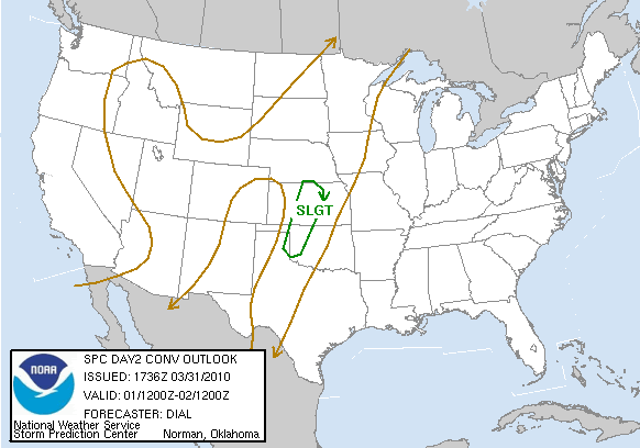
SPC AC 311736
DAY 2 CONVECTIVE OUTLOOK CORR 2
NWS STORM PREDICTION CENTER NORMAN OK
1236 PM CDT WED MAR 31 2010
VALID 011200Z - 021200Z
...THERE IS A SLGT RISK OF SVR TSTMS OVER A PORTION OF WRN OK
THROUGH CNTRL KS...
CORRECTED FIRST SENTENCE IN LAST PARAGRAPH
...SYNOPSIS...
LARGE UPPER TROUGH APPROACHING THE CA COAST WILL AMPLIFY OVER THE
WRN STATES INTO THURSDAY AND SUBSEQUENTLY ADVANCE EWD...REACHING THE
CNTRL AND SRN HIGH PLAINS LATER THURSDAY NIGHT. LEAD SHORTWAVE
TROUGH EMBEDDED WITHIN THE BROADER TROUGH IS FORECAST TO EJECT NEWD
THROUGH THE CNTRL HIGH PLAINS DURING THE AFTERNOON...THEN CONTINUE
INTO THE NRN PLAINS OVERNIGHT.
AT THE SURFACE THE INITIAL CYCLONE WILL DEEPEN OVER THE CNTRL HIGH
PLAINS IN ASSOCIATION WITH EJECTING LEAD IMPULSE AND CONTINUE NEWD
ALONG BAROCLINIC ZONE THROUGH THE NRN PLAINS AND UPPER MS VALLEY.
SECONDARY CYCLOGENESIS WILL COMMENCE OVER THE SRN HIGH PLAINS
THURSDAY NIGHT IN ASSOCIATION WITH ASCENT ATTENDING SHORTWAVE TROUGH
ROTATING THROUGH THE BASE OF PRIMARY UPPER TROUGH. DRYLINE WILL
SETUP OVER THE CNTRL AND SRN PLAINS. A WARM FRONT WILL EXTEND EWD
FROM THE CNTRL PLAINS CYCLONE AND LIFT NWD THROUGH THE UPPER MS
VALLEY. POLAR FRONT WILL ADVANCE INTO THE CNTRL PLAINS IN WAKE OF
EJECTING IMPULSE AND LIKELY OVERTAKE THE DRYLINE THURSDAY NIGHT.
PACIFIC FRONT WILL ACCOMPANY LOWER LATITUDE SHORTWAVE TROUGH INTO
THE SRN HIGH PLAINS WHERE IT WILL LIKELY MERGE WITH THE DRYLINE LATE
THURSDAY NIGHT.
Carla/Alicia/Jerry(In The Eye)/Michelle/Charley/Ivan/Dennis/Katrina/Rita/Wilma/Humberto/Ike/Harvey
Member: National Weather Association
Facebook.com/Weather Infinity
Twitter @WeatherInfinity
Member: National Weather Association
Facebook.com/Weather Infinity
Twitter @WeatherInfinity
Noticed HPC has the front backing back up through SE TX early Sunday. If the front does move east of SE TX Saturday, it doesn't for long....
Afternoon update from HGX:
HERE IS STILL SOME UNCERTAINTY TO THE THREAT OF SEVERE. FIRST
THERE WILL PROBABLY BE A LOW STRATUS DECK OVER MUCH OF SE AND E
TX DURING THE MORNING FRI. THIS WILL LIMIT DAYTIME HEATING AND
THUS LIMIT INSTABILITY. THE OTHER CONCERN WILL BE THE QUALITY OF
RETURNING BOUNDARY LAYER MOISTURE. GIVEN COOLER GULF WATERS...MAY
HAVE DEWPOINT TEMPS TOP OUT IN THE MID 60S BUT HARD TO SAY HOW
FAR NORTH THE MOISTURE WILL ADVECT. THE GFS THINKS THERE WILL BE
ENOUGH MOISTURE AND SOME CLEARING OVER C TX TO DEPICT A BAND OF
2000 J/KG CAPE AT 00Z SAT BASICALLY THROUGH A WEDGE FROM AUSTIN
TO CONROE AND UP TO THE METROPLEX. SHOULD THIS ACTUALLY PAN
OUT...THERE MAY BE AN INCREASED THREAT FOR SEVERE WEATHER OVER
THE BRAZOS VALLEY AND EASTWARD FOR THE EVENING HOURS. BASIC
OUTLINE OF THE THREAT DURING THE EVENING WILL BE NORTH OF A
BRENHAM TO LUFKIN LINE. MAIN THREATS WILL BE SEVERE WIND/HAIL BUT
A ROTATING SUPERCELL THAT DEVELOPS IN THE UNSTABLE WARM SECTOR
CANNOT BE RULED OUT. THIS AT LEAST PRESENTS A SMALL TORNADO
THREAT BUT SINCE LOW LEVEL WINDS VEER DURING THE
AFTERNOON...THINK THE THREAT WILL BE SMALL.
A COLD FRONT WILL PUSH SOUTH LATE IN THE EVENING AND OVERNIGHT BUT INSTABILITY WILL
BE LIMITED AS DAY TIME HEATING IS LOST. THERE SHOULD AT LEAST BE
A SQUALL LINE THAT FORMS ON THE FRONT AND PUSHES ACROSS SE TX
OVERNIGHT. THERE MAY BE A SMALL ISO SEVERE THREAT FOR WIND/HAIL
OVER THE HOUSTON METRO WITH THIS SQUALL LINE BUT THESE CHANCES
LOOK RATHER SMALL AT THE MOMENT.
As for the front:
COLD FRONT FRI NIGHT/SAT MORNING DOES PUSH OFF THE COAST BUT NOT
VERY FAR. STRONG RETURN FLOW SETS UP SAT NIGHT INTO SUN MORNING
SO THE FRONT MOVES NORTH AS A WARM FRONT ON EASTER SUNDAY. WILL
KEEP SOME MENTION OF SHOWERS AND ISO THUNDER BUT CONFIDENCE IS
RATHER LOW WITH THIS. SUSPECT THERE WILL BE MORE CLOUDS AND GULF
MOISTURE MOVING BACK INTO SE TX THAN CHANCES OF THUNDER.
I did notice that the 12z GFS MOS pushes rain chance up to 30% Sunday.
-
sleetstorm
- Posts: 651
- Joined: Thu Feb 04, 2010 12:33 pm
- Contact:
So the problem in getting severe thunderstorms to develop in southeast Texas during Good Friday into early Saturday morning is that the temperature is not warm enough, or that the dew point is not high enough? What is SE Texas lacking that would cause severe thunderstorms to be much more feasible and widespread srainhoutx, Ed Mahmoud, and wxdata? Please help me out here.
Last edited by sleetstorm on Wed Mar 31, 2010 6:03 pm, edited 1 time in total.


We could use the rain this weekend.
-
sleetstorm
- Posts: 651
- Joined: Thu Feb 04, 2010 12:33 pm
- Contact:
What about peoples' Easter plans, Ptarmigan? Do you think that they would not be ruined if showers/thunderstorms were to come through this area this Sunday?