

Now we can ask the question- why is HGX still in clear air mode? Light rain in the Galleria area..
edit- guess they read our forum, in precip mode now..
edit 2- guess not, back in clear air mode....
April Weather Discussion.
-
srainhoutx

- Site Admin

- Posts: 19616
- Joined: Tue Feb 02, 2010 2:32 pm
- Location: Maggie Valley, NC
- Contact:
I am beginning to think that the front may stall near or just W of our area. I noticed Austin-Bergstrom is at 75 with dewpoints in the upper 60's at this hour. Should that occur, it may throw another wrinkle in the weekend forecast.
Carla/Alicia/Jerry(In The Eye)/Michelle/Charley/Ivan/Dennis/Katrina/Rita/Wilma/Humberto/Ike/Harvey
Member: National Weather Association
Facebook.com/Weather Infinity
Twitter @WeatherInfinity
Member: National Weather Association
Facebook.com/Weather Infinity
Twitter @WeatherInfinity
-
Poltracker
- Posts: 44
- Joined: Wed Feb 03, 2010 7:38 pm
- Location: Deer Park, Texas
- Contact:
srainhoutx wrote:I am beginning to think that the front may stall near or just W of our area. I noticed Austin-Bergstrom is at 75 with dewpoints in the upper 60's at this hour. Should that occur, it may throw another wrinkle in the weekend forecast.
For a novice, what ind of wrinkle would that be?
HGX thinks the dry lines stalls, but the weak front makes it for a few hours. So does HPC
20z RUC dims are chances for rain today.
Cams out of Galveston show sea fog rolling in.
Also our dry line/front has finally made it across I-35....
Also our dry line/front has finally made it across I-35....
-
sleetstorm
- Posts: 651
- Joined: Thu Feb 04, 2010 12:33 pm
- Contact:
I take it that our chances for getting any severe thunderstorms are have been totally disintegrated.
-
wxman57

- Global Moderator

- Posts: 2621
- Joined: Thu Feb 04, 2010 5:34 am
- Location: Southwest Houston (Westbury)
- Contact:
I got a sprinkle this afternoon - not enough to wet the ground. Looks to be about it for this system. All the activity is well NE of us up in Arkansas. Looks like a relatively nice weekend in store. Mid 80s! Biking weather!
The line (small as it is) is to the northwest of Houston (as of 1:40am.) Winds are NW behind the line, so that is the front. So far, no lightning in this line.
-
srainhoutx
- Site Admin
- Posts: 19616
- Joined: Tue Feb 02, 2010 2:32 pm
- Location: Maggie Valley, NC
- Contact:
Fog has lifted and skies are clear with a light S wind in NW Harris County this morning. Front? Not here. Enjoy the bike ride wxman57 and get the sun screen ready. 
Carla/Alicia/Jerry(In The Eye)/Michelle/Charley/Ivan/Dennis/Katrina/Rita/Wilma/Humberto/Ike/Harvey
Member: National Weather Association
Facebook.com/Weather Infinity
Twitter @WeatherInfinity
Member: National Weather Association
Facebook.com/Weather Infinity
Twitter @WeatherInfinity
-
srainhoutx
- Site Admin
- Posts: 19616
- Joined: Tue Feb 02, 2010 2:32 pm
- Location: Maggie Valley, NC
- Contact:
Cloud may linger a bit longer than expected today. HGX Morning Update...
AREA FORECAST DISCUSSION
NATIONAL WEATHER SERVICE HOUSTON/GALVESTON TX
1000 AM CDT SUN APR 4 2010
.UPDATE...
MORNING UPDATE BELOW.
&&
.DISCUSSION...
ANOTHER EPISODE OF SEA FOG IS AFFECTING THE COAST AROUND GALVESTON
BAY. ISSUED A DENSE FOG ADVISORY FOR GALVESTON/CHAMBERS COUNTIES
THROUGH NOON. HOPING THE FOG BEGINS TO ERODE BY THEN BUT A STRONG
TEMPERATURE INVERSION...LITTLE MIXING AS STRONGER WINDS ALOFT WILL
HAVE A HARD TIME REACHING THE MARINE SURFACE AND A CONTINUED FLOW
OF VERY MOIST AIR OVER THE COOLER SHELF WATERS WILL CONTINUE A
THREAT FOR FOG. SKIES WILL BEGIN TO CLEAR OVER INLAND AREAS THIS
AFTERNOON AS THE INVERSION WEAKENS A BIT AND INLAND WINDS BEGIN TO
INCREASE. NEW ZONES ARE ALREADY OUT. ANOTHER UPDATE MAY BE NEEDED
IF THE SEA FOG LINGERS. 43
Carla/Alicia/Jerry(In The Eye)/Michelle/Charley/Ivan/Dennis/Katrina/Rita/Wilma/Humberto/Ike/Harvey
Member: National Weather Association
Facebook.com/Weather Infinity
Twitter @WeatherInfinity
Member: National Weather Association
Facebook.com/Weather Infinity
Twitter @WeatherInfinity
As of Noon, Galveston Beach still pretty socked in with fog.
-
srainhoutx
- Site Admin
- Posts: 19616
- Joined: Tue Feb 02, 2010 2:32 pm
- Location: Maggie Valley, NC
- Contact:
I'll edit the Topic to cover April now. It does appear that we may be heading into an active severe weather season. Tomorrow night may spawn so bumpy weather in Central TX if the cap can be broken.Ed Mahmoud wrote:Out of holidays for about 7 weeks.
Carla/Alicia/Jerry(In The Eye)/Michelle/Charley/Ivan/Dennis/Katrina/Rita/Wilma/Humberto/Ike/Harvey
Member: National Weather Association
Facebook.com/Weather Infinity
Twitter @WeatherInfinity
Member: National Weather Association
Facebook.com/Weather Infinity
Twitter @WeatherInfinity
Both the 12z GFS and NAM indicate a mixed bag of severe weather indices on Wednesday. Cap still strong. Unless that changes, may be another yawner for SE TX Wednesday.
-
srainhoutx
- Site Admin
- Posts: 19616
- Joined: Tue Feb 02, 2010 2:32 pm
- Location: Maggie Valley, NC
- Contact:
HGX thoughts this afternoon. Perhaps a chance of storms as the rather strong early Spring Cold Front makes a run on SE TX...
AREA FORECAST DISCUSSION
NATIONAL WEATHER SERVICE HOUSTON/GALVESTON TX
231 PM CDT MON APR 5 2010
.DISCUSSION...
NO REAL CHANGES FOR THE NEXT 36 HOURS AS A MODERATE TO STRONG
ONSHORE FLOW CONTINUES. AM EXPECTING CLOUDINESS TO INCREASE AGAIN
TONIGHT AND MIX OUT BY MID AFTERNOON ON TUESDAY. OVERNIGHT LOW
TEMPERATURES WILL REMAIN WELL ABOVE NORMAL TONIGHT AND AGAIN
TUESDAY NIGHT DUE TO THE CLOUDS AND MIXING. WEDNESDAY IS A TOUGH
CALL ON POPS/RAIN POTENTIAL. PW VALUES REACH 1.5 INCHES AND UPPER LEVEL
WINDS LOOK FAVORABLE AS SOUTHEAST TEXAS WILL LIE IN A RIGHT REAR
QUAD AND A SPLITTING JET. FORECAST SOUNDINGS SHOW A LARGE CAPPING
INVERSION IN PLACE THROUGH WEDNESDAY MORNING WHICH SUDDENLY
VANISHES JUST AS THE FRONT APPROACHES. MODELS HAVE ERODED THE CAP
TOO FAST OVER THE LAST COUPLE OF EVENTS SO NOT SURE IF THE CAP
WILL ERODE AS ADVERTISED. THAT SAID...UPPER LEVEL DYNAMICS LOOK
IMPRESSIVE ENOUGH TO BREAK/ERODE THE CAP. WILL MAINTAIN CHANCE
POPS FOR NOW...BUT BUMPED THEM UP SLIGHTLY OVER THE EXTREME
SOUTHEAST. THE ECMWF/UK AND CAN ARE ALL SLOWER WITH THE FRONT.
SLOWED THINGS DOWN A BIT AND PARED BACK ON THE RAPID CLEARING BY
ABOUT SIX HOURS. AFTER THE FRONT...COOLER AND DRIER AIR WILL WORK
INTO THE REGION. THE LATTER HALF OF THE WEEK LOOKS FANTASTIC WITH
WARM DAYS...COOL NIGHTS AND RELATIVELY LOW HUMIDITY LEVELS.
Carla/Alicia/Jerry(In The Eye)/Michelle/Charley/Ivan/Dennis/Katrina/Rita/Wilma/Humberto/Ike/Harvey
Member: National Weather Association
Facebook.com/Weather Infinity
Twitter @WeatherInfinity
Member: National Weather Association
Facebook.com/Weather Infinity
Twitter @WeatherInfinity
-
sleetstorm
- Posts: 651
- Joined: Thu Feb 04, 2010 12:33 pm
- Contact:
How good does the feasibility for severe thunderstorms look for the day after tomorrow? What percentage does southeast Texas have at getting severe thunderstorms?


Should be interesting.
0z NAM still shows marginal instability but it does erode the cap by late afternoon. That would mean at least thunderstorms for at least someone in SE TX Wednesday (unless of course as the NWS wrote this afternoon, the models are again underestimating the cap again.)
0z GFS looking a little better for possible severe weather Wednesday afternoon.
0z GFS looking a little better for possible severe weather Wednesday afternoon.
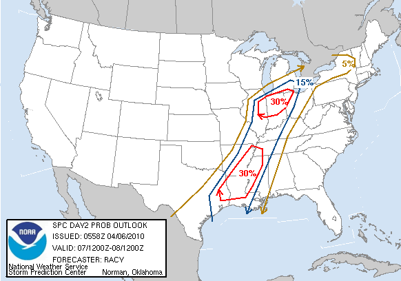
SPC now putting SE TX under slight risk Wednesday (although this dog has barked before...)
"...S TX...
PRECEDING THE SEWD SURGING CDFNT...BOUNDARY LAYER ACROSS THE REGION
WILL BECOME MODERATELY UNSTABLE OWING TO MID/UPR 60S SFC DEW POINTS
BENEATH STEEP MID-LVL LAPSE RATES. TSTMS WILL LIKELY BUILD SWWD
FROM THE UPR TX COAST SWWD ALONG THE FRONT INTO S TX DURING THE
AFTN. CAP WILL BE AN ISSUE AND STORM COVERAGE SHOULD REMAIN ISOLD.
HOWEVER...DMGG WIND GUSTS/HAIL MAY ACCOMPANY ANY STORM THAT DOES
MANAGE TO BECOME ESTABLISHED. "
-
srainhoutx
- Site Admin
- Posts: 19616
- Joined: Tue Feb 02, 2010 2:32 pm
- Location: Maggie Valley, NC
- Contact:
Could get a bit bumpy as the SPC has expanded the Slight Risk area into SE TX for Wednesday...
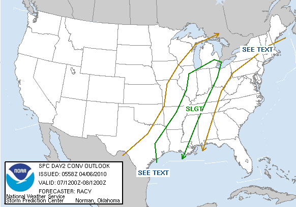
DAY 2 CONVECTIVE OUTLOOK
NWS STORM PREDICTION CENTER NORMAN OK
1258 AM CDT TUE APR 06 2010
VALID 071200Z - 081200Z
...THERE IS A SLGT RISK OF SVR TSTMS FROM THE MIDWEST TO THE WRN
GULF COASTAL REGION...
...SYNOPSIS...
UPR TROUGH EVOLVING OVER THE WRN STATES WILL AMPLIFY OVER THE PLAINS
TUESDAY NIGHT AND THEN MIGRATE INTO THE GRTLKS...MIDWEST AND
LWR/MID-MS VLY BY 12Z THURSDAY. SFC LOW...INITIALLY OVER NCNTRL MO
WILL TRANSLATE INTO SRN ONTARIO DURING THE DAY TUESDAY WITH A CDFNT
SWEEPING SEWD. THE FRONT WILL REACH OH...WRN TN...LA BY EARLY
THURSDAY MORNING. MEANWHILE...A WRMFNT WILL DEVELOP NWD INTO CNTRL
NEW ENGLAND AND CNTRL/NRN NY DURING WEDNESDAY AFTN.
...MIDWEST TO THE WRN GULF COASTAL REGION...
CORRIDOR OF GULF MOISTURE ARCING AROUND THE SFC HIGH OVER THE SWRN
ATLC WILL MAINTAIN A MODESTLY UNSTABLE ENVIRONMENT IN A NARROW ZONE
ALONG/AHEAD OF THE CDFNT ON WEDNESDAY. CINH WILL BE QUITE
ROBUST...BUT APPROACH OF ASCENT TIED WITH THE UPR TROUGH WILL WEAKEN
THE EML. THUS...BANDS OF TSTMS WILL INTENSIFY WITHIN EXISTING
MORNING CONVECTION AND JUST AHEAD OF THE FRONT FROM IL SWWD TO E TX
BY MID-AFTN.
SSWLY DEEP-LAYER FLOW WILL LARGELY BE ALIGNED WITH THE FRONT BUT
CONTAIN STRONG SPEED SHEAR. THUS...WHILE LINEAR STORM MODES WILL BE
FAVORED...EMBEDDED SUPERCELLS WILL BE POSSIBLE ALONG WITH LEWPS/BOWS
WITH DMGG WINDS AND LARGE HAIL. ISOLD TORNADOES WILL BE
POSSIBLE...PARTICULARLY ALONG THE TRACK OF THE SFC LOW OVER PARTS OF
IL NEWD INTO SRN LWR MI AND NRN IND. COMPARATIVELY MORE ROBUST
MOISTURE AND SLIGHTLY HIGHER PROBABILITY FOR LONGER-LIVED DISCRETE
CELLS WILL BE SUPPORTIVE OF TORNADOES ACROSS THE MID-SOUTH SWWD INTO
PARTS OF LA/E TX AS WELL.
STRONGER ACTIVITY WILL LIKELY TRACK ENE INTO THE OH VLY WEDNESDAY
NIGHT WHILE WEAKENING. SVR THREATS WILL CONTINUE ALL NIGHT FARTHER
TO THE S FROM WRN TN SWWD INTO THE LWR MS VLY WHERE HIGH WINDS/HAIL
AND ISOLD TORNADOES WILL BE POSSIBLE.
...S TX...
PRECEDING THE SEWD SURGING CDFNT...BOUNDARY LAYER ACROSS THE REGION
WILL BECOME MODERATELY UNSTABLE OWING TO MID/UPR 60S SFC DEW POINTS
BENEATH STEEP MID-LVL LAPSE RATES. TSTMS WILL LIKELY BUILD SWWD
FROM THE UPR TX COAST SWWD ALONG THE FRONT INTO S TX DURING THE
AFTN. CAP WILL BE AN ISSUE AND STORM COVERAGE SHOULD REMAIN ISOLD.
HOWEVER...DMGG WIND GUSTS/HAIL MAY ACCOMPANY ANY STORM THAT DOES
MANAGE TO BECOME ESTABLISHED.
...CNTRL/NRN NY...
BUILDING HEIGHTS AND INCREASING CINH WILL OCCUR IN ADVANCE OF THE
PLAINS UPR TROUGH ACROSS THE ERN SEABOARD ON WEDNESDAY. CORRIDOR OF
MID-UPR 50S SFC DEW POINTS...EXPECTED HEATING AND LLVL CONVERGENCE
INVOF THE WRMFNT MAY BE SUFFICIENT FOR ISOLD TSTMS ACROSS CNTRL/NRN
NY. SHOULD A STORM FORM...PRESENCE OF STEEP MID-TROPOSPHERIC LAPSE
RATES AND CLOSE PROXIMITY OF 50 KTS OF WLY MID-LVL FLOW WILL BE
FAVORABLE FOR ORGANIZED SVR STORMS. ATTM...STORM COVERAGE IS
EXPECTED TO REMAIN ISOLD.
..RACY.. 04/06/2010
Carla/Alicia/Jerry(In The Eye)/Michelle/Charley/Ivan/Dennis/Katrina/Rita/Wilma/Humberto/Ike/Harvey
Member: National Weather Association
Facebook.com/Weather Infinity
Twitter @WeatherInfinity
Member: National Weather Association
Facebook.com/Weather Infinity
Twitter @WeatherInfinity
-
- Information
-
Who is online
Users browsing this forum: Ahrefs [Bot], Amazon [Bot], Bing [Bot], Cromagnum, Semrush [Bot] and 68 guests