
April Weather Discussion.

The storm moving out of northeastern Ft. Bend into Western Harris county is a very proficient rain and lightning maker. Have over 1 inch in the rain bucket and its only been raining for about 20min. Also, there are a ton of cloud to ground lightning strikes with the storm as well so be careful if your going to be going out on the western side of the county.

Also, Nexrad suggest .25" hail possible with the storm.
-
srainhoutx

- Site Admin

- Posts: 19616
- Joined: Tue Feb 02, 2010 2:32 pm
- Location: Maggie Valley, NC
- Contact:
Getting some rumbles of thunder now in NW Harris County. Very dark skies to my S as well.
Carla/Alicia/Jerry(In The Eye)/Michelle/Charley/Ivan/Dennis/Katrina/Rita/Wilma/Humberto/Ike/Harvey
Member: National Weather Association
Facebook.com/Weather Infinity
Twitter @WeatherInfinity
Member: National Weather Association
Facebook.com/Weather Infinity
Twitter @WeatherInfinity


It is raining and I hear thunder outside.
Echo tops with the storms in Harris county approaching 30,000 ft.
-
srainhoutx
- Site Admin
- Posts: 19616
- Joined: Tue Feb 02, 2010 2:32 pm
- Location: Maggie Valley, NC
- Contact:
Over an inch of rain at my location and still coming down. My allergies are grateful. 
Carla/Alicia/Jerry(In The Eye)/Michelle/Charley/Ivan/Dennis/Katrina/Rita/Wilma/Humberto/Ike/Harvey
Member: National Weather Association
Facebook.com/Weather Infinity
Twitter @WeatherInfinity
Member: National Weather Association
Facebook.com/Weather Infinity
Twitter @WeatherInfinity
Does anyone know if this cluster of storms is going to increase in size or is this all we will get today?
Neat shot from one of the Weather Bug cameras showing the storms moving northeast of the Galleria and brighter skies to the west...
-
TexasMetBlake
- Pro Met

- Posts: 839
- Joined: Wed Feb 03, 2010 7:03 pm
- Location: Spring/Woodlands
- Contact:
Just in from church and the drive from Greenway to The Woodlands was SLOW and the weather was HORRIBLE!!! I bet the rainfall rates EASILY topped an inch and a half an hour at times. Man, that's the hardest rain I've seen in a while...
Quite a rainfall it was.Candy Cane wrote:Just in from church and the drive from Greenway to The Woodlands was SLOW and the weather was HORRIBLE!!! I bet the rainfall rates EASILY topped an inch and a half an hour at times. Man, that's the hardest rain I've seen in a while...
-
weatherguy425
- Pro Met
- Posts: 830
- Joined: Wed Feb 03, 2010 7:45 pm
- Location: Atlanta, Georgia
- Contact:
Storms re-firing
They may be along the actual front.weatherguy425 wrote:Storms re-firing
-
weatherguy425
- Pro Met
- Posts: 830
- Joined: Wed Feb 03, 2010 7:45 pm
- Location: Atlanta, Georgia
- Contact:
There also appears to be a boundary moving NW off of earlier storms in the mix.
-
srainhoutx
- Site Admin
- Posts: 19616
- Joined: Tue Feb 02, 2010 2:32 pm
- Location: Maggie Valley, NC
- Contact:
Slow moving storms have dumped another inch of rain in NW Harris County.
Carla/Alicia/Jerry(In The Eye)/Michelle/Charley/Ivan/Dennis/Katrina/Rita/Wilma/Humberto/Ike/Harvey
Member: National Weather Association
Facebook.com/Weather Infinity
Twitter @WeatherInfinity
Member: National Weather Association
Facebook.com/Weather Infinity
Twitter @WeatherInfinity
-
weatherguy425
- Pro Met
- Posts: 830
- Joined: Wed Feb 03, 2010 7:45 pm
- Location: Atlanta, Georgia
- Contact:
Tornado Warning
--------------------------------------------------------------------------------
SEVERE WEATHER STATEMENT
NATIONAL WEATHER SERVICE CORPUS CHRISTI TX
654 PM CDT SUN APR 18 2010
TXC057-190000-
/O.CON.KCRP.TO.W.0006.000000T0000Z-100419T0000Z/
CALHOUN-
654 PM CDT SUN APR 18 2010
...A TORNADO WARNING REMAINS IN EFFECT UNTIL 700 PM CDT FOR NORTH
CENTRAL CALHOUN COUNTY...
AT 647 PM CDT...TRAINED WEATHER SPOTTERS REPORTED A FUNNEL CLOUD.
THIS TORNADO WAS LOCATED NEAR KAMAY...OR 7 MILES SOUTHWEST OF PORT
LAVACA...MOVING EAST AT 10 MPH.
* LOCATIONS IMPACTED INCLUDE...
PORT LAVACA...
PRECAUTIONARY/PREPAREDNESS ACTIONS...
IF YOU ARE CAUGHT OUTSIDE...SEEK SHELTER IN A NEARBY REINFORCED
BUILDING. AS A LAST RESORT...SEEK SHELTER IN A CULVERT...DITCH OR LOW
SPOT AND COVER YOUR HEAD WITH YOUR HANDS.
&&
LAT...LON 2863 9655 2863 9660 2859 9660 2857 9658
2846 9664 2858 9680 2866 9673 2869 9665
2864 9660 2865 9658 2867 9657 2866 9653
TIME...MOT...LOC 2354Z 285DEG 8KT 2855 9669
Doesn't look impressive at all on radar, maybe a waterspout?
-
sleetstorm
- Posts: 651
- Joined: Thu Feb 04, 2010 12:33 pm
- Contact:
Are any of you getting anything from the rather healthy thunderstorm that is currently and mainly in northern Harris County? Some of it is in the Houston metroplex area too.
yep, had some decent thunder and lightning here in kingwood...its tapering off now though.
-
sleetstorm
- Posts: 651
- Joined: Thu Feb 04, 2010 12:33 pm
- Contact:
A rather healthy small line of thunderstorms seem to be heading toward Baytown even as we speak.
-
biggerbyte
- Posts: 1142
- Joined: Thu Feb 04, 2010 12:15 am
- Location: Porter, Texas. (Montgomery County)
- Contact:
Porter got some good rains today. I hope all of you did as well.
BB
BB
-
srainhoutx
- Site Admin
- Posts: 19616
- Joined: Tue Feb 02, 2010 2:32 pm
- Location: Maggie Valley, NC
- Contact:
Some concern about capping issues on Thursday, but SPC has our area in the 4-8 day longer range outlook for Friday as the cap breaks down and a rather potent piece of Upper Level energy swings through TX and the Southern Plains...
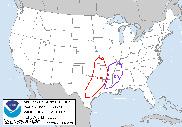
DAY 4-8 CONVECTIVE OUTLOOK
NWS STORM PREDICTION CENTER NORMAN OK
0346 AM CDT TUE APR 20 2010
VALID 231200Z - 281200Z
...DISCUSSION...
A LARGE UPPER STORM SYSTEM WILL CONTINUE MOVING SLOWLY EWD
INTO/ACROSS THE CENTRAL U.S. DURING THE FIRST TWO DAYS OF THE
PERIOD...AFTER WHICH THE SYSTEM IS EXPECTED TO BEGIN
WEAKENING/SHIFTING MORE NEWD TOWARD THE MIDWEST. MODELS BEGIN TO
DIVERGE FAIRLY SUBSTANTIALLY DAY 6 AND BEYOND...BUT AGREEMENT IS
SUFFICIENT DAYS 4-5 /FRI. AND SAT. APR. 24-25/ TO BOOST CONFIDENCE
WITH RESPECT TO THE EVOLUTION OF SEVERE POTENTIAL.
IT APPEARS ATTM THAT A WIDESPREAD AREA OF FAIRLY SUBSTANTIAL SEVERE
THREAT WILL EXIST DAY 4 /FRI THE 24TH/...WITH THE GREATEST THREAT
APPARENT ATTM FROM SERN KS/SWRN MO SSWWD INTO SERN TX. HERE...A
MOIST/UNSTABLE PRE-FRONTAL AIRMASS IS EXPECTED...AND WITH FAVORABLE
SHEAR -- INCLUDING MID-LEVEL FLOW IN EXCESS OF 50 KT -- ATOP THE
FRONTAL ZONE...THE OVERALL ENVIRONMENT APPEARS FAVORABLE FOR AN
ACTIVE SEVERE WEATHER EVENT.
ENHANCED SEVERE POTENTIAL SHOULD SPREAD EWD INTO THE MS VALLEY
REGION DAY 5 /SAT. THE 25TH/...WITH A SIMILARLY FAVORABLE KINEMATIC
AND THERMODYNAMIC ENVIRONMENT LIKELY NEAR/AHEAD OF THE ADVANCING
FRONT. BOTH DAYS...LARGE HAIL AND DAMAGING WINDS WILL BE
POSSIBLE...WHILE THE MOIST BOUNDARY LAYER AND FAVORABLY-STRONG SHEAR
ARE ALSO INDICATIVE OF TORNADO POTENTIAL.
COMBINATION OF THE DECREASING MODEL AGREEMENT AND VEERING LOW-LEVEL
FLOW DAY 6 ACROSS THE SOUTHEAST AS THE UPPER SYSTEM TURNS MORE NELY
PRECLUDES THE ISSUANCE OF A THREAT AREA. NONETHELESS...SOME SEVERE
POTENTIAL WILL LIKELY EXIST -- PARTICULARLY E OF THE MS AND S OF THE
OH VALLEYS.
..GOSS.. 04/20/2010
Carla/Alicia/Jerry(In The Eye)/Michelle/Charley/Ivan/Dennis/Katrina/Rita/Wilma/Humberto/Ike/Harvey
Member: National Weather Association
Facebook.com/Weather Infinity
Twitter @WeatherInfinity
Member: National Weather Association
Facebook.com/Weather Infinity
Twitter @WeatherInfinity