April Weather Discussion.

General Weather Discussions and Analysis
User avatar
srainhoutx
Site Admin
Site Admin
Posts: 19616
Joined: Tue Feb 02, 2010 2:32 pm
Location: Maggie Valley, NC
Contact:

SPC has a large area under a Slight Risk for Friday that includes SE TX. It appears that timing and capping will be the main issues that will need to be ironed out over the next couple of days. Perhaps a Moderate Risk Upgrade? We shall see.

Image

DAY 3 CONVECTIVE OUTLOOK
NWS STORM PREDICTION CENTER NORMAN OK
0230 AM CDT WED APR 21 2010

VALID 231200Z - 241200Z

...THERE IS A SLGT RISK OF SVR TSTMS ACROSS A LARGE PORTION OF THE
CENTRAL AND S CENTRAL CONUS...

...SYNOPSIS...
LARGE WRN U.S. UPPER STORM SYSTEM WILL CONTINUE MOVING EWD INTO THE
CENTRAL U.S. THIS PERIOD...ACCOMPANIED BY A SEASONABLY-STRONG
DEEP-LAYER WIND FIELD. AT THE SURFACE...A COMPLEX EVOLUTION IS
EXPECTED...BUT WILL INCLUDE A COLD FRONT SHIFTING EWD ACROSS THE
PLAINS AND A WARM FRONT MOVING NWD ACROSS THE MID MS/MID MO VALLEY
REGION.

...MID MO/MID MS VALLEYS SWD TO THE WRN AND CENTRAL GULF COASTS...
ANOTHER DAY OF WIDESPREAD/POTENTIALLY SIGNIFICANT SEVERE WEATHER IS
FORECAST...COVERING THE CENTRAL U.S. FROM PARTS OF NEB/SRN IA/IL SWD
TO ERN TX/LA/MS...AHEAD OF THE EXPANSIVE UPPER SYSTEM AS IT
PROGRESSES EWD INTO THE CENTRAL CONUS. A COMPLEX SURFACE EVOLUTION
IS FORECAST -- THUS MAKING AREAS OF GREATEST SEVERE POTENTIAL
DIFFICULT TO DISCERN ATTM.
OVERALL HOWEVER...IT APPEARS THAT
CONCENTRATED AREAS OF STORM DEVELOPMENT WILL EVOLVE BOTH
ALONG/AHEAD OF THE COLD FRONT AS IT CROSSES THE CENTRAL AND SRN
PLAINS...AND INVOF THE WARM FRONT WHICH SHOULD EXTEND ESEWD FROM NEB
INTO THE MID MS/TN VALLEY REGION DURING THE AFTERNOON AND EVENING.
WITH A LARGE MOIST/UNSTABLE WARM SECTOR IN PLACE AND WITH
STRONG/VEERING WIND FIELD WITH HEIGHT...EXPECT NUMEROUS
SEVERE/SUPERCELL STORMS -- PRIMARILY FROM EARLY AFTERNOON THROUGH
MID EVENING.


AGAIN -- WHILE DETAILED EVOLUTION CANNOT BE ASCERTAINED ATTM...IT
APPEARS THAT A RELATIVE TORNADO MAXIMUM MAY OCCUR INVOF THE WARM
FRONT -- I.E. ACROSS MO AND VICINITY...WHILE POTENTIAL FOR VERY
LARGE HAIL MAY BE MAXIMIZED FROM SERN OK SSWWD INTO THE HILL COUNTRY
AND ADJACENT PORTIONS OF SERN TX
.


FARTHER E -- INTO THE LOWER AND MID MS VALLEY REGION -- THE IMPETUS
FOR STORM INITIATION WITHIN THE BROAD WARM SECTOR REMAINS MORE
UNCERTAIN. HOWEVER...GIVEN FAVORABLE KINEMATIC AND THERMODYNAMIC
ENVIRONMENT...WILL EXTEND THE SLIGHT RISK EWD ACROSS AR/TX AND INTO
WRN TN...MS...AND LA.

..GOSS.. 04/21/2010
Carla/Alicia/Jerry(In The Eye)/Michelle/Charley/Ivan/Dennis/Katrina/Rita/Wilma/Humberto/Ike/Harvey

Member: National Weather Association
Facebook.com/Weather Infinity
Twitter @WeatherInfinity
Houstonkid
Posts: 53
Joined: Mon Feb 08, 2010 2:31 pm
Contact:

From: Lindner Jeffrey


An impressive upper level storm system moving into the west coast.

Ridge will break down over TX starting today and into Thursday with southerly air flow returning Gulf moisture to the region. Upper level storm will drop into the SW US and then eject NE in pieces starting Friday. W TX dry line will surge eastward each afternoon and then retreat westward during the evening hours with thunderstorm chances tied to this feature Thursday and Friday afternoons.

Main event appears pegged for Friday night into Saturday as main upper storm moves toward Kansas and secondary piece of energy drops into the base of the trough over N MX and S NM and then rounds into TX. Impressive dynamics and severe weather parameters will be in place Friday night and Saturday over the entire region with surface based instability of 2000 J/kg or greater and very strong low level wind shear (0-1km of 300 m^2/s^2) with soundings showing long curved hodographs supportive of long live supercells. Forecast soundings also show a tremendous capping inversion advected out of NE MX in a mid level SW flow ahead of the short wave Friday evening. NAM and ECMWF suggest this cap is weakened by mid level cooling and lift and will be breakable by late afternoon across SC and C TX ahead of the dry line while the GFS suggest the cap will be too strong to overcome.

Line of thinking from SPC on this event is that with enough surface heating and track of the short wave the cap will be broken allowing rapid development of severe convection Friday evening along the dry line from W of CRP to AUS to DFW. Extremely favorable severe parameters support rapid growth of supercells with rotation and a high threat of extreme sized hail and a decent tornado potential mainly west of a line from Huntsville to Columbus to Victoria. Initial development of discrete supercells may grow upscale into a linear squall line or MCS and move eastward to northeast overnight into a favorably backed low level flow off the Gulf increasing the damaging wind threat eastward into the late night hours and into Saturday.

Evolution of this system and potential severe weather event bears close watch over the next 24-36 hours as additional data will become available on severe indices and forecasted cap intensity. SPC has already outlooked the entire region for DAY 3.
User avatar
wxdata
Site Admin
Site Admin
Posts: 1059
Joined: Wed Feb 03, 2010 3:04 pm
Location: Houston, TX
Contact:

New 12z NAM showing cap holding until Saturday morning near fropa time. However same model showing heaviest rains staying just north of south SE TX. Most severe indicies are all in the red well before the frontal passage. Once again it appears the cap is holding the cards. Bottom line- wait and see for frontal timing and the strength of the cap.
sleetstorm
Posts: 651
Joined: Thu Feb 04, 2010 12:33 pm
Contact:

So, while one model says that severe thunderstorms are not that likely, another one says that SE Texas could feasibly be receiving some serious and ominous thunderstorms, right?
User avatar
wxdata
Site Admin
Site Admin
Posts: 1059
Joined: Wed Feb 03, 2010 3:04 pm
Location: Houston, TX
Contact:

sleetstorm wrote:So, while one model says that severe thunderstorms are not that likely, another one says that SE Texas could feasibly be receiving some serious and ominous thunderstorms, right?
GFS is showing less cap but quicker frontal passage. It also shows a rather unstable atmo. Seen similar, but each time heavier storms stayed north. A few more days to watch it all..
User avatar
wxdata
Site Admin
Site Admin
Posts: 1059
Joined: Wed Feb 03, 2010 3:04 pm
Location: Houston, TX
Contact:

HPC's map kind of tells the story on their thinking for rain on Friday night/Saturday morning's event. The map may very well mirror where the largest bulk of severe weather may end up as well..
sleetstorm
Posts: 651
Joined: Thu Feb 04, 2010 12:33 pm
Contact:

Hey, I want to apologize to all of you if any of my posts that I have posted, since the day that I signed on to this forum and the old forum too, were slightly lofty to any of you.
User avatar
wxdata
Site Admin
Site Admin
Posts: 1059
Joined: Wed Feb 03, 2010 3:04 pm
Location: Houston, TX
Contact:

Ed, you're pretty right on. Closest hatched area from central TX to SW Arkansas. Wouldn't rule out a rogue severe thunderstorm this far south, but most severe weather should stay further north...
User avatar
srainhoutx
Site Admin
Site Admin
Posts: 19616
Joined: Tue Feb 02, 2010 2:32 pm
Location: Maggie Valley, NC
Contact:

HGX thoughts this morning. I noticed the SPC came very close to upgrading to a Moderte Risk both today and tomoorrow as well.

AREA FORECAST DISCUSSION
NATIONAL WEATHER SERVICE HOUSTON/GALVESTON TX
520 AM CDT THU APR 22 2010

.DISCUSSION...
ABUNDANT MID/HIGH CLOUDS MOVING IN FROM THE WEST TODAY BUT STILL
NO SIGNIFICANT POPS IN THE NEAR FUTURE. THIS STRONG CAP IN PLACE
SHOULD HOLD THIS AFTN...WITH JUST PERHAPS SOME ISOLATED WAA TYPE
SHOWERS OVERNIGHT OVER THE SRN THIRD OF THE CWA. THEN FOR FRI...
NOT SEEING A LOT (FROM THE MODELS) THAT WOULD BE ENOUGH TO BREAK
THE CAP SO WILL KEEP POPS LOW THROUGH THE AFTN. HOWEVER THE SAME
CANNOT BE SAID FOR THE FRI NIGHT/SAT MORNING TIMEFRAME. A STRONG
S/WV MOVING AROUND THE BASE OF THE MAIN UPPER LOW IS EXPECTED TO
PUSH ACROSS THE STATE...LIKELY PRODUCING A DECENT AMOUNT OF CON-
VECTION WITH ITS PASSAGE. ATTM CONFIDENCE NOT THAT HIGH WITH THE
IDEA OF SVR WITH THESE STORMS (SEE SPC`S DAY2 OUTLOOK) GIVEN THE
TIME OF DAY AND UNCERTAINTY WITH THE CAP. HOWEVER THE PROGS OF A
SPLITTING JET ALOFT/PWS APPROACHING 2" AND FAVORABLE SHEAR PROF-
ILES SHOULD MAKE FOR AN INTERESTING NIGHT NONETHELESS
.


CLEARING/DRIER BY SUN IN THE WAKE OF THE WEAK PACIFIC COOL FRONT
WITH MILD SEASONAL WX RETURNING ONCE AGAIN. HOWEVER IN THE LONG-
RANGE GUIDANCE...THERE ARE HINTS AT MORE TROUBLE AS THEY DEVELOP
A DOUBLE BUBBLE IN THE TROF ALOFT TOWARD THE END OF NEXT WEEK.
41
Carla/Alicia/Jerry(In The Eye)/Michelle/Charley/Ivan/Dennis/Katrina/Rita/Wilma/Humberto/Ike/Harvey

Member: National Weather Association
Facebook.com/Weather Infinity
Twitter @WeatherInfinity
Houstonkid
Posts: 53
Joined: Mon Feb 08, 2010 2:31 pm
Contact:

HOWEVER IN THE LONG-
RANGE GUIDANCE...THERE ARE HINTS AT MORE TROUBLE AS THEY DEVELOP
A DOUBLE BUBBLE IN THE TROF ALOFT TOWARD THE END OF NEXT WEEK.
Any one care to elaborate on this? what exactly does "double bubble" imply/mean?
User avatar
srainhoutx
Site Admin
Site Admin
Posts: 19616
Joined: Tue Feb 02, 2010 2:32 pm
Location: Maggie Valley, NC
Contact:

Houstonkid wrote:
HOWEVER IN THE LONG-
RANGE GUIDANCE...THERE ARE HINTS AT MORE TROUBLE AS THEY DEVELOP
A DOUBLE BUBBLE IN THE TROF ALOFT TOWARD THE END OF NEXT WEEK.
Any one care to elaborate on this? what exactly does "double bubble" imply/mean?
SPC is already mentioning this in the Longer Range Convective Outlook..

DAY 4-8 CONVECTIVE OUTLOOK
NWS STORM PREDICTION CENTER NORMAN OK
0345 AM CDT THU APR 22 2010

VALID 251200Z - 301200Z

...DISCUSSION...
SEVERE WEATHER FOCUS IS ON THE MIDDLE AND SRN ATLANTIC
COAST/SOUTHEAST U.S. DAY 4 /SUN. APR. 25/...WHERE MEDIUM-RANGE
MODELS DEPICT CONTINUED EWD ADVANCEMENT OF THE SURFACE COLD FRONT
TOWARD -- AND EVENTUALLY OFF -- THE MIDDLE AND SRN ATLANTIC COAST.
VERY STRONG FLOW ALOFT IS FORECAST TO REMAIN ATOP THE WARM
SECTOR...PROVIDING SHEAR FAVORABLE FOR SUPERCELLS. THIS COMBINED
WITH A MOIST ENVIRONMENT DESTABILIZING THROUGH THE AFTERNOON APPEARS
SUPPORTIVE OF THE POTENTIAL FOR WIDESPREAD SEVERE WEATHER ACROSS
THIS AREA.

BY DAY 5 /MON. APR. 26/...THE FRONT WILL LIKELY HAVE MOVED WELL OFF
THE ATLANTIC COAST. WHILE THE TRAILING PORTION OF THE BOUNDARY
SHOULD BE SHIFTING SWD ACROSS THE FL PENINSULA...WEAK LAPSE RATES
ARE INDICATED -- SUGGESTING POTENTIAL FOR DESTABILIZATION WILL BE
LIMITED. THUS -- DESPITE ENHANCED FLOW ALOFT...CONFIDENCE IN
SIGNIFICANT SEVERE WEATHER REMAINS RATHER LOW ATTM.

AS THE MAIN ERN U.S. UPPER TROUGH APPROACHES THE ATLANTIC COAST DAY
5 BUT LINGERS OVER ERN CANADA/NEW ENGLAND...THE NEXT MAJOR
TROUGH/LOW IS FORECAST TO DIG SEWD ACROSS THE WRN U.S. TOWARD THE
DESERT SW THROUGH DAY 7 /WED. APR. 28/. THE GFS AND ECMWF -- WHILE
DIFFERENT IN THE DETAILS...AGREE THAT THIS LOW/TROUGH SHOULD MOVE
EWD DAY 8...WITH AN EXPANDING CENTRAL/SRN PLAINS WARM SECTOR
EVOLVING EAST OF LEE CYCLOGENESIS. THIS SUGGESTS INCREASING SEVERE
POTENTIAL INTO/THROUGH DAY 8 /THU. APR. 29/...BUT ATTM CONFIDENCE IN
THIS EVOLUTION IS NOT SUFFICIENT TO WARRANT THE INTRODUCTION OF A
THREAT AREA.

..GOSS.. 04/22/2010
Carla/Alicia/Jerry(In The Eye)/Michelle/Charley/Ivan/Dennis/Katrina/Rita/Wilma/Humberto/Ike/Harvey

Member: National Weather Association
Facebook.com/Weather Infinity
Twitter @WeatherInfinity
Houstonkid
Posts: 53
Joined: Mon Feb 08, 2010 2:31 pm
Contact:

Jeff Lindner Thursday AM email.

Battle between favorable dynamics and severe weather indices and strong capping inversion will play out over TX Friday afternoon into Saturday.

Very strong and large upper level storm system centered over the SW US this morning will move toward the ENE today with energy spreading into the plains. Lift along the dry line in W TX will set off numerous severe thunderstorms by early evening, but these will remain well west of our region. Increasing southeasterly flow off the Gulf will spread lower TX coast mid to upper 60 degree dewpoints northward into the region by this afternoon. Increasing capping in the mid levels will keep convection from developing today and for most of Friday although a few streamer showers may develop under the inversion in the moisture return.

Main event targeted for late Friday night into early Saturday morning where potential remains for a bumpy period. Models are now is good agreement that a strong vort max will rotate through the base of the upper trough over the central US with the track of this feature from NE MX toward Texarkana. Rapid formation of a deepening surface low in NE MX late Friday afternoon will track NE with low level flow backing to the SE and ESE below strong 60-80kt of SW flow in the mid levels. This brings strong directional and speed shear into much of eastern TX by Friday evening. Surface dry line will be heated and will likely be the point of ignition by late Friday afternoon from N of Austin to near Del Rio. Very unstable air mass with LI’s to -8 and CAPE of 2000-3000 J/kg support explosive development once inversion is removed or broken. Surface low sweeps NE overnight and linear forcing south of this feature will bring strong lift to SC and SE TX helping to erode any remaining capping inversion. Models continue to show highest rain chances and track of strongest storms from roughly Del Rio to College Station to NW Louisiana with a somewhat glancing blow to SE TX. Not sure if this will play out as the models suggest as meso scale influences may help drive a squall line deeper into the area.

While severe weather appears likely given forecasted atmospheric indices, the time of day of the forecasted event (late night/early morning) will likely help to mute this threat some. Additionally, there remains questions as to the cap intensity over the southern part of the region which could greatly affect where the strongest storms track. SPC continues to highlight the entire region for a slight risk and see no reason why to disagree with the proper uncertainties noted.
User avatar
kayci
Posts: 358
Joined: Thu Feb 04, 2010 10:30 am
Location: Alvin
Contact:

It's gonna rain on my birthday...... :(
User avatar
wxdata
Site Admin
Site Admin
Posts: 1059
Joined: Wed Feb 03, 2010 3:04 pm
Location: Houston, TX
Contact:

12z NAM- I-10 is the dividing line between the haves and have-nots (as far as for rain amounts..)
User avatar
wxdata
Site Admin
Site Admin
Posts: 1059
Joined: Wed Feb 03, 2010 3:04 pm
Location: Houston, TX
Contact:

12z NAM- Develops coastal low and swings it our way. If valid, it may indeed be an interesting Saturday morning for some!

By 10am Saturday morning, NAM shows cap gone and (hey, Ed) LFC & LCL near surface!
sleetstorm
Posts: 651
Joined: Thu Feb 04, 2010 12:33 pm
Contact:

kayci wrote:It's gonna rain on my birthday...... :(
Your birthday is this saturday, kayci?
User avatar
kayci
Posts: 358
Joined: Thu Feb 04, 2010 10:30 am
Location: Alvin
Contact:

sleetstorm wrote:
kayci wrote:It's gonna rain on my birthday...... :(
Your birthday is this saturday, kayci?

It's tomorrow, but will end on Sunday. ;)
biggerbyte
Posts: 1142
Joined: Thu Feb 04, 2010 12:15 am
Location: Porter, Texas. (Montgomery County)
Contact:

It looks like folks north and east will get in on the "big" action this time. However, that does not mean that we in s.e. Texas will be left out. Just like with the last event when many said we were going to be dry, the same uncertainty remains with this event. If you need a more detailed view of these weather events, follow Jeff's blog. He was right on last go round, and he is with this one as well. Watch for Friday morning's forecast. I would not be surprised, the way things are shaping up now, to see much less confidence in this cap. Still, again, expect bigger things north of Montgomery County as this unfolds Friday night, and on Saturday.
User avatar
wxman57
Global Moderator
Global Moderator
Posts: 2621
Joined: Thu Feb 04, 2010 5:34 am
Location: Southwest Houston (Westbury)
Contact:

Chances for anything significant here look slim. Frontal timing (just after sunrise) won't "help", either.
User avatar
srainhoutx
Site Admin
Site Admin
Posts: 19616
Joined: Tue Feb 02, 2010 2:32 pm
Location: Maggie Valley, NC
Contact:

Moderate Risk up for our neighbors in AR and Northern LA.

Image
Image

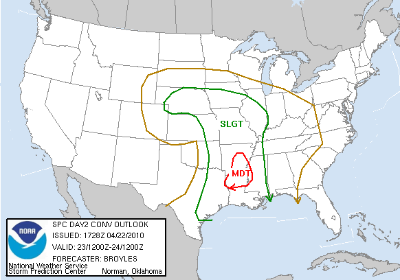
DAY 2 CONVECTIVE OUTLOOK
NWS STORM PREDICTION CENTER NORMAN OK
1228 PM CDT THU APR 22 2010

VALID 231200Z - 241200Z

...THERE IS A MDT RISK OF SVR TSTMS ACROSS PARTS OF AR AND NRN LA...

...THERE IS A SLGT RISK OF SVR TSTMS ACROSS PARTS OF THE LOWER MS
VALLEY...SRN PLAINS...OZARKS...MID MO VALLEY AND SRN PLAINS...

...A SIGNIFICANT SEVERE WEATHER EVENT POSSIBLE LATE FRIDAY AFTERNOON
INTO FRIDAY EVENING ACROSS PARTS OF AR AND NRN LA...
...THE START OF A TORNADO OUTBREAK POSSIBLE LATE FRIDAY NIGHT INTO
SATURDAY MORNING POSSIBLE ACROSS THE ARKLATEX AND LOWER MS VALLEY...


...LOWER TO MID MS VALLEY...
A WELL-DEVELOPED SYSTEM OVER THE CNTRL ROCKIES WILL MOVE INTO THE
SRN PLAINS FRIDAY. AN IMPRESSIVE 80 TO 90 KT MID-LEVEL JET WILL
ROUND THE BASE OF THE UPPER-LEVEL TROUGH MOVING QUICKLY NEWD INTO
THE SRN PLAINS FRIDAY AFTERNOON. AS LARGE-SCALE ASCENT INCREASES
ACROSS THE ARKLATEX...A LOW-LEVEL JET IS FORECAST TO STRENGTHEN AND
MOVE NWD ACROSS LA INTO SRN AR. CONVECTION ASSOCIATED WITH THE
LOW-LEVEL JET SHOULD INITIATE ACROSS NRN LA AND SRN AR FRIDAY
AFTERNOON WITH THE STORMS EXPANDING QUICKLY IN COVERAGE ACROSS ERN
AR...NRN MS AND SRN MO. FORECAST SOUNDINGS FRIDAY AFTERNOON IN NRN
LA AND SRN AR SHOW MODERATE INSTABILITY...STRONG DEEP LAYER SHEAR
WITH 0-1 KM SHEAR AROUND 30 KT. THIS ENVIRONMENT SHOULD BE FAVORABLE
FOR SUPERCELLS WITH A POTENTIAL FOR TORNADOES ESPECIALLY IF THE
DEVELOPING STORMS BECOME SFC-BASED BY LATE FRIDAY AFTERNOON. AN
ISOLATED STRONG TORNADO ALONG WITH A SUBSTANTIAL WIND DAMAGE THREAT
WILL BE POSSIBLE AS STORMS MOVE QUICKLY NEWD OUT OF NRN LA ACROSS
ERN AR AND WRN MS FRIDAY EVENING.

DURING THE OVERNIGHT PERIOD...THE UPPER-LEVEL SYSTEM ACROSS THE
GREAT PLAINS IS FORECAST TO BECOME INCREASINGLY ORGANIZED. MODEL
FORECASTS DEVELOP A PRONOUNCED LOW-LEVEL JET ACROSS THE NW GULF OF
MEXICO FRIDAY NIGHT...MOVING THIS FEATURE QUICKLY NNEWD ACROSS LA
AROUND DAYBREAK SATURDAY. THUNDERSTORMS ARE FORECAST TO INITIATE
ALONG THE WRN EDGE OF THE LOW-LEVEL JET ACROSS EAST TX AFTER
MIDNIGHT WITH THIS CONVECTION SPREADING NEWD ACROSS THE ARKLATEX
LATE FRIDAY NIGHT INTO SATURDAY MORNING. INCREASING LARGE-SCALE
ASCENT ASSOCIATED WITH THE EXIT REGION OF AN APPROACHING MID-LEVEL
JET...STRONG VERTICAL SHEAR AND MODERATE INSTABILITY SHOULD MAKE
CONDITIONS VERY FAVORABLE FOR SUPERCELLS ACROSS THE ARKLATEX LATE IN
THE PERIOD. FORECAST SOUNDINGS ACROSS NRN LA AND SRN AR FROM 09Z TO
12Z SATURDAY SUGGEST LOW-LEVEL SHEAR WILL RAPIDLY BECOME FAVORABLE
FOR TORNADOES. THE SYNOPTIC SETUP ALONG WITH OUTPUT FROM VARIOUS
SEVERE PARAMETERS SUGGEST THAT A TORNADO OUTBREAK MAY START LATE
FRIDAY NIGHT ACROSS NRN LA...SRN AR...WRN MS AND POSSIBLY FAR NE TX.
TORNADOES WILL BE POSSIBLE WITH THE MORE DOMINANT DISCRETE
SUPERCELLS WITH A FEW STRONG TORNADOES POSSIBLE. IN ADDITION...LARGE
HAIL AND WIND DAMAGE APPEARS LIKELY WITH SUPERCELLS THAT DEVELOP
FRIDAY NIGHT.

THE MAIN UNCERTAINTY CONCERNING THE OUTBREAK POTENTIAL IS TIMING
WITH THE LOW-LEVEL JET LATE IN THE PERIOD. AT THIS POINT...MODEL
FORECASTS FOCUS THE LOW-LEVEL JET ACROSS THE ARKLATEX AND LOWER MS
VALLEY JUST BEYOND 12Z ON SATURDAY SUGGESTING THE POTENTIAL FOR A
TORNADO OUTBREAK COULD HOLD OFF UNTIL AFTER 12Z SATURDAY.

...MID-MO VALLEY...
AN UPPER-LEVEL LOW IS FORECAST TO MOVE INTO THE CNTRL PLAINS FRIDAY
AS A CORRIDOR OF LOW-LEVEL MOISTURE SETS UP FROM ERN KS NWWD ACROSS
SRN NEB WHERE SFC DEWPOINTS SHOULD BE IN THE MID 50S TO LOWER 60S F.
MODEL FORECASTS DEVELOP MODERATE INSTABILITY FROM CNTRL NEB SEWD
ACROSS ERN KS AND WRN MO. THUNDERSTORMS APPEAR LIKELY TO INITIATE
ALONG THE INSTABILITY AXIS LATE FRIDAY AFTERNOON WHERE FORECASTS
SOUNDINGS SHOW STEEP MID-LEVEL LAPSE RATES AND MODERATE TO STRONG
VERTICAL SHEAR SUGGESTING SUPERCELLS WITH LARGE HAIL WILL BE
POSSIBLE. VERY LARGE HAIL MAY OCCUR WITH THE MORE DOMINANT
SUPERCELLS ACROSS ERN NEB...FAR NE KS AND NW MO AS THE EXIT REGION
OF A MID-LEVEL JET MOVES INTO THE REGION FROM THE SOUTH. THIS
COMBINED WITH MLCAPE VALUES AROUND 2000 J/KG AND 850 TO 500 MB LAPSE
RATES BETWEEN 7.0 AND 7.5 C/KM MAY BE SUFFICIENT FOR VERY LARGE
HAIL. THIS THREAT FOR 2 INCH AND GREATER SIZE HAIL SHOULD BE FOCUSED
WITH THE MORE DOMINANT SUPERCELLS ACROSS ERN NEB...FAR NE KS AND NW
MO AS THE EXIT REGION OF A MID-LEVEL JET MOVES INTO THE REGION FROM
THE SOUTH LATE FRIDAY AFTERNOON.

..BROYLES.. 04/22/2010
Carla/Alicia/Jerry(In The Eye)/Michelle/Charley/Ivan/Dennis/Katrina/Rita/Wilma/Humberto/Ike/Harvey

Member: National Weather Association
Facebook.com/Weather Infinity
Twitter @WeatherInfinity
Post Reply
  • Information
  • Who is online

    Users browsing this forum: Ahrefs [Bot], Bing [Bot] and 58 guests