Page 16 of 31
Re: April Weather Discussion. Storm Chance Late Week?
Posted: Tue Apr 20, 2010 11:44 am
by wxdata
12z NAM Bufkit soundings show that as suggested by the NWS, there will be a nice cap over the area Friday. However if there's enough forcing, any thunderstorms that bursts through the cap could quickly become 'supercells' Friday afternoon.
Re: April Weather Discussion. Storm Chance Late Week?
Posted: Tue Apr 20, 2010 11:57 am
by sleetstorm
I do not ever recall experiencing a Supercell Thunderstorm.
Re: April Weather Discussion. Storm Chance Late Week?
Posted: Tue Apr 20, 2010 12:01 pm
by sleetstorm
wxdata wrote:12z NAM Bufkit soundings show that as suggested by the NWS, there will be a nice cap over the area Friday. However if there's enough forcing, any thunderstorms that bursts through the cap could quickly become 'supercells' Friday afternoon.
Southeast Texas could have a slight to moderate Supercell Thunderstorm outbreak this friday if all of the components in the atmosphere come together just right, huh, wxdata?
Re: April Weather Discussion. Storm Chance Late Week?
Posted: Tue Apr 20, 2010 12:11 pm
by wxdata
sleetstorm wrote:
Southeast Texas could have a slight to moderate Supercell Thunderstorm outbreak this friday if all of the components in the atmosphere come together just right, huh, wxdata?
Our ol' friend/nemesis (depending on one's point of view) 'the cap' will once again be holding the aces in this hand of Friday's weather.
Re: April Weather Discussion. Storm Chance Late Week?
Posted: Tue Apr 20, 2010 2:37 pm
by wxdata
HPC's QPF suggests that the cap may be partially responsible for the greatest rain amounts staying north and east at weeks end (and the fact that most of the main energy stays further north as well.)
Re: April Weather Discussion. Storm Chance Late Week?
Posted: Tue Apr 20, 2010 3:04 pm
by medicalgirl32
ok everybody i am having a crawfish boil on Saturday outside and we have a band playing! It starts at 4pm. Are we goin to get drenched!!
Re: April Weather Discussion. Storm Chance Late Week?
Posted: Tue Apr 20, 2010 3:59 pm
by sleetstorm
wxdata wrote:sleetstorm wrote:
Southeast Texas could have a slight to moderate Supercell Thunderstorm outbreak this friday if all of the components in the atmosphere come together just right, huh, wxdata?
Our ol' friend/nemesis (depending on one's point of view) 'the cap' will once again be holding the aces in this hand of Friday's weather.
What does that mean, wxdata, that the chances of a slight to moderate Supercell Thunderstorm outbreak are not in our favor?
Re: April Weather Discussion. Storm Chance Late Week?
Posted: Tue Apr 20, 2010 5:24 pm
by wxdata
What does that mean, wxdata, that the chances of a slight to moderate Supercell Thunderstorm outbreak are not in our favor?
Strong southwest winds aloft usually keep the cap strong here. Under current forecasts, the only chance for severe would occur with the upward forcing from the front late Friday/early Saturday. Even then the chance is slight or less ( for here.)
That being said, the NAM may not yet go out far enough into the future. The 12z GFS is looking a little more favorable for severe weather early Saturday morning.
Re: April Weather Discussion. Storm Chance Late Week?
Posted: Tue Apr 20, 2010 10:44 pm
by sleetstorm
Okay, thank you wxdata.

Hey, who knows, perhaps the front will easily overcome the cap enough to where a slight to moderate Supercell Thunderstorm outbreak does in fact happen to be the case of transpiring. Just my thoughts.
Re: April Weather Discussion. Storm Chance Late Week?
Posted: Tue Apr 20, 2010 11:16 pm
by Ptarmigan
Now, if we could find a way to get rid of this southwestern cockroach wind aloft and cockroach cap.....................

Re: April Weather Discussion. Storm Chance Late Week?
Posted: Wed Apr 21, 2010 6:10 am
by srainhoutx
SPC has a large area under a Slight Risk for Friday that includes SE TX. It appears that timing and capping will be the main issues that will need to be ironed out over the next couple of days. Perhaps a Moderate Risk Upgrade? We shall see.
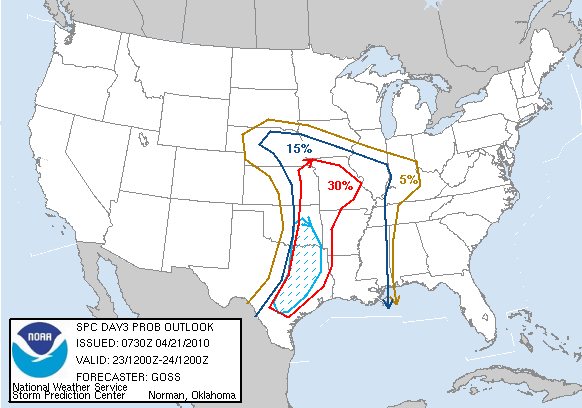
DAY 3 CONVECTIVE OUTLOOK
NWS STORM PREDICTION CENTER NORMAN OK
0230 AM CDT WED APR 21 2010
VALID 231200Z - 241200Z
...THERE IS A SLGT RISK OF SVR TSTMS ACROSS A LARGE PORTION OF THE
CENTRAL AND S CENTRAL CONUS...
...SYNOPSIS...
LARGE WRN U.S. UPPER STORM SYSTEM WILL CONTINUE MOVING EWD INTO THE
CENTRAL U.S. THIS PERIOD...ACCOMPANIED BY A SEASONABLY-STRONG
DEEP-LAYER WIND FIELD. AT THE SURFACE...A COMPLEX EVOLUTION IS
EXPECTED...BUT WILL INCLUDE A COLD FRONT SHIFTING EWD ACROSS THE
PLAINS AND A WARM FRONT MOVING NWD ACROSS THE MID MS/MID MO VALLEY
REGION.
...MID MO/MID MS VALLEYS SWD TO THE WRN AND CENTRAL GULF COASTS...
ANOTHER DAY OF WIDESPREAD/POTENTIALLY SIGNIFICANT SEVERE WEATHER IS
FORECAST...COVERING THE CENTRAL U.S. FROM PARTS OF NEB/SRN IA/IL SWD
TO ERN TX/LA/MS...AHEAD OF THE EXPANSIVE UPPER SYSTEM AS IT
PROGRESSES EWD INTO THE CENTRAL CONUS. A COMPLEX SURFACE EVOLUTION
IS FORECAST -- THUS MAKING AREAS OF GREATEST SEVERE POTENTIAL
DIFFICULT TO DISCERN ATTM. OVERALL HOWEVER...IT APPEARS THAT
CONCENTRATED AREAS OF STORM DEVELOPMENT WILL EVOLVE BOTH
ALONG/AHEAD OF THE COLD FRONT AS IT CROSSES THE CENTRAL AND SRN
PLAINS...AND INVOF THE WARM FRONT WHICH SHOULD EXTEND ESEWD FROM NEB
INTO THE MID MS/TN VALLEY REGION DURING THE AFTERNOON AND EVENING.
WITH A LARGE MOIST/UNSTABLE WARM SECTOR IN PLACE AND WITH
STRONG/VEERING WIND FIELD WITH HEIGHT...EXPECT NUMEROUS
SEVERE/SUPERCELL STORMS -- PRIMARILY FROM EARLY AFTERNOON THROUGH
MID EVENING.
AGAIN -- WHILE DETAILED EVOLUTION CANNOT BE ASCERTAINED ATTM...IT
APPEARS THAT A RELATIVE TORNADO MAXIMUM MAY OCCUR INVOF THE WARM
FRONT -- I.E. ACROSS MO AND VICINITY...WHILE POTENTIAL FOR VERY
LARGE HAIL MAY BE MAXIMIZED FROM SERN OK SSWWD INTO THE HILL COUNTRY
AND ADJACENT PORTIONS OF SERN TX.
FARTHER E -- INTO THE LOWER AND MID MS VALLEY REGION -- THE IMPETUS
FOR STORM INITIATION WITHIN THE BROAD WARM SECTOR REMAINS MORE
UNCERTAIN.
HOWEVER...GIVEN FAVORABLE KINEMATIC AND THERMODYNAMIC
ENVIRONMENT...WILL EXTEND THE SLIGHT RISK EWD ACROSS AR/TX AND INTO
WRN TN...MS...AND LA.
..GOSS.. 04/21/2010
Re: April Weather Discussion. SPC: Slight Risk Late Week!
Posted: Wed Apr 21, 2010 7:01 am
by Houstonkid
From: Lindner Jeffrey
An impressive upper level storm system moving into the west coast.
Ridge will break down over TX starting today and into Thursday with southerly air flow returning Gulf moisture to the region. Upper level storm will drop into the SW US and then eject NE in pieces starting Friday. W TX dry line will surge eastward each afternoon and then retreat westward during the evening hours with thunderstorm chances tied to this feature Thursday and Friday afternoons.
Main event appears pegged for Friday night into Saturday as main upper storm moves toward Kansas and secondary piece of energy drops into the base of the trough over N MX and S NM and then rounds into TX. Impressive dynamics and severe weather parameters will be in place Friday night and Saturday over the entire region with surface based instability of 2000 J/kg or greater and very strong low level wind shear (0-1km of 300 m^2/s^2) with soundings showing long curved hodographs supportive of long live supercells. Forecast soundings also show a tremendous capping inversion advected out of NE MX in a mid level SW flow ahead of the short wave Friday evening. NAM and ECMWF suggest this cap is weakened by mid level cooling and lift and will be breakable by late afternoon across SC and C TX ahead of the dry line while the GFS suggest the cap will be too strong to overcome.
Line of thinking from SPC on this event is that with enough surface heating and track of the short wave the cap will be broken allowing rapid development of severe convection Friday evening along the dry line from W of CRP to AUS to DFW. Extremely favorable severe parameters support rapid growth of supercells with rotation and a high threat of extreme sized hail and a decent tornado potential mainly west of a line from Huntsville to Columbus to Victoria. Initial development of discrete supercells may grow upscale into a linear squall line or MCS and move eastward to northeast overnight into a favorably backed low level flow off the Gulf increasing the damaging wind threat eastward into the late night hours and into Saturday.
Evolution of this system and potential severe weather event bears close watch over the next 24-36 hours as additional data will become available on severe indices and forecasted cap intensity. SPC has already outlooked the entire region for DAY 3.
Re: April Weather Discussion. SPC: Slight Risk Late Week!
Posted: Wed Apr 21, 2010 11:02 am
by wxdata
New 12z NAM showing cap holding until Saturday morning near fropa time. However same model showing heaviest rains staying just north of south SE TX. Most severe indicies are all in the red well before the frontal passage. Once again it appears the cap is holding the cards. Bottom line- wait and see for frontal timing and the strength of the cap.
Re: April Weather Discussion. SPC: Slight Risk Late Week!
Posted: Wed Apr 21, 2010 11:35 am
by sleetstorm
So, while one model says that severe thunderstorms are not that likely, another one says that SE Texas could feasibly be receiving some serious and ominous thunderstorms, right?
Re: April Weather Discussion. SPC: Slight Risk Late Week!
Posted: Wed Apr 21, 2010 12:41 pm
by wxdata
sleetstorm wrote:So, while one model says that severe thunderstorms are not that likely, another one says that SE Texas could feasibly be receiving some serious and ominous thunderstorms, right?
GFS is showing less cap but quicker frontal passage. It also shows a rather unstable atmo. Seen similar, but each time heavier storms stayed north. A few more days to watch it all..
Re: April Weather Discussion. SPC: Slight Risk Late Week!
Posted: Wed Apr 21, 2010 2:11 pm
by wxdata
HPC's map kind of tells the story on their thinking for rain on Friday night/Saturday morning's event. The map may very well mirror where the largest bulk of severe weather may end up as well..
Re: April Weather Discussion. SPC: Slight Risk Late Week!
Posted: Wed Apr 21, 2010 7:55 pm
by sleetstorm
Hey, I want to apologize to all of you if any of my posts that I have posted, since the day that I signed on to this forum and the old forum too, were slightly lofty to any of you.
Re: April Weather Discussion. SPC: Slight Risk Late Week!
Posted: Thu Apr 22, 2010 2:04 am
by wxdata
Ed, you're pretty right on. Closest hatched area from central TX to SW Arkansas. Wouldn't rule out a rogue severe thunderstorm this far south, but most severe weather should stay further north...
Re: April Weather Discussion. SPC: Slight Risk Late Week!
Posted: Thu Apr 22, 2010 6:06 am
by srainhoutx
HGX thoughts this morning. I noticed the SPC came very close to upgrading to a Moderte Risk both today and tomoorrow as well.
AREA FORECAST DISCUSSION
NATIONAL WEATHER SERVICE HOUSTON/GALVESTON TX
520 AM CDT THU APR 22 2010
.DISCUSSION...
ABUNDANT MID/HIGH CLOUDS MOVING IN FROM THE WEST TODAY BUT STILL
NO SIGNIFICANT POPS IN THE NEAR FUTURE. THIS STRONG CAP IN PLACE
SHOULD HOLD THIS AFTN...WITH JUST PERHAPS SOME ISOLATED WAA TYPE
SHOWERS OVERNIGHT OVER THE SRN THIRD OF THE CWA. THEN FOR FRI...
NOT SEEING A LOT (FROM THE MODELS) THAT WOULD BE ENOUGH TO BREAK
THE CAP SO WILL KEEP POPS LOW THROUGH THE AFTN. HOWEVER THE SAME
CANNOT BE SAID FOR THE FRI NIGHT/SAT MORNING TIMEFRAME. A STRONG
S/WV MOVING AROUND THE BASE OF THE MAIN UPPER LOW IS EXPECTED TO
PUSH ACROSS THE STATE...LIKELY PRODUCING A DECENT AMOUNT OF CON-
VECTION WITH ITS PASSAGE. ATTM CONFIDENCE NOT THAT HIGH WITH THE
IDEA OF SVR WITH THESE STORMS (SEE SPC`S DAY2 OUTLOOK) GIVEN THE
TIME OF DAY AND UNCERTAINTY WITH THE CAP. HOWEVER THE PROGS OF A
SPLITTING JET ALOFT/PWS APPROACHING 2" AND FAVORABLE SHEAR PROF-
ILES SHOULD MAKE FOR AN INTERESTING NIGHT NONETHELESS.
CLEARING/DRIER BY SUN IN THE WAKE OF THE WEAK PACIFIC COOL FRONT
WITH MILD SEASONAL WX RETURNING ONCE AGAIN. HOWEVER IN THE LONG-
RANGE GUIDANCE...THERE ARE HINTS AT MORE TROUBLE AS THEY DEVELOP
A DOUBLE BUBBLE IN THE TROF ALOFT TOWARD THE END OF NEXT WEEK.
41
Re: April Weather Discussion. SPC: Slight Risk Late Week!
Posted: Thu Apr 22, 2010 6:22 am
by Houstonkid
HOWEVER IN THE LONG-
RANGE GUIDANCE...THERE ARE HINTS AT MORE TROUBLE AS THEY DEVELOP
A DOUBLE BUBBLE IN THE TROF ALOFT TOWARD THE END OF NEXT WEEK.
Any one care to elaborate on this? what exactly does "double bubble" imply/mean?