
Yep. NRL has Debby up already.Scott747 wrote:Looks like 96l will be upgraded with advisories initiated at 4.
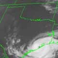
Post Tropical Cyclone Debby. Exiting E Over The Atlantic
-
srainhoutx

- Site Admin

- Posts: 19616
- Joined: Tue Feb 02, 2010 2:32 pm
- Location: Maggie Valley, NC
- Contact:
Carla/Alicia/Jerry(In The Eye)/Michelle/Charley/Ivan/Dennis/Katrina/Rita/Wilma/Humberto/Ike/Harvey
Member: National Weather Association
Facebook.com/Weather Infinity
Twitter @WeatherInfinity
Member: National Weather Association
Facebook.com/Weather Infinity
Twitter @WeatherInfinity
-
srainhoutx
- Site Admin
- Posts: 19616
- Joined: Tue Feb 02, 2010 2:32 pm
- Location: Maggie Valley, NC
- Contact:
Product: Air Force Vortex Message (URNT12 KNHC)
Transmitted: 23rd day of the month at 19:27Z
Aircraft: Air Force Aircraft (Last 3 digits of the tail number are 302)
Mission Purpose: Investigate first suspect area (flight in the North Atlantic basin)
Mission Number: 1
Observation Number: 07
A. Time of Center Fix: 23rd day of the month at 18:37:40Z
B. Center Fix Coordinates: 25°54'N 87°50'W (25.9N 87.8333W)
B. Center Fix Location: 313 miles (503 km) to the SSE (154°) from New Orleans, LA, USA.
C. Minimum Height at Standard Level: Not Available
D. Estimated (by SFMR or visually) Maximum Surface Wind: 15kts (~ 17.3mph)
E. Location of the Estimated Maximum Surface Wind: 14 nautical miles (16 statute miles) to the ENE (63°) of center fix
F. Maximum Flight Level Wind Inbound: From 165° at 17kts (From the SSE at ~ 19.6mph)
G. Location of Maximum Flight Level Wind Inbound: 73 nautical miles (84 statute miles) to the ENE (65°) of center fix
H. Minimum Sea Level Pressure: 1002mb (29.59 inHg) - Extrapolated
I. Maximum Flight Level Temp & Pressure Altitude Outside Eye: 24°C (75°F) at a pressure alt. of 340m (1,115ft)
J. Maximum Flight Level Temp & Pressure Altitude Inside Eye: 24°C (75°F) at a pressure alt. of 338m (1,109ft)
K. Dewpoint Temp (collected at same location as temp inside eye): 24°C (75°F)
K. Sea Surface Temp (collected at same location as temp inside eye): Not Available
L. Eye Character: Not Available
M. Eye Shape: Not Available
N. Fix Determined By: Penetration, Wind and Pressure
N. Fix Level: 1,500 feet
O. Navigation Fix Accuracy: 0.02 nautical miles
O. Meteorological Accuracy: 5 nautical miles
Remarks Section - Remarks That Were Decoded...
Maximum Flight Level Wind: 17kts (~ 19.6mph) in the northeast quadrant at 18:11:00Z
Maximum Flight Level Wind Outbound: 26kts (~ 29.9mph) in the southwest quadrant at 18:52:00Z
Sea Level Pressure Extrapolation From: Below 1,500 feet
Remarks Section - Additional Remarks...
PEAK SFC WND 32KTS NW QUAD AT 17:08:20Z
Carla/Alicia/Jerry(In The Eye)/Michelle/Charley/Ivan/Dennis/Katrina/Rita/Wilma/Humberto/Ike/Harvey
Member: National Weather Association
Facebook.com/Weather Infinity
Twitter @WeatherInfinity
Member: National Weather Association
Facebook.com/Weather Infinity
Twitter @WeatherInfinity
-
srainhoutx
- Site Admin
- Posts: 19616
- Joined: Tue Feb 02, 2010 2:32 pm
- Location: Maggie Valley, NC
- Contact:
HPC Final afternoon Medium Range Discussion:
FINAL...
THE AVAILABLE 12Z MODEL GUIDANCE OFFERED NO COMPELLING REASON TO
MAKE ANY CHANGES FOR THE FINAL DAY 3-7 FORECAST. IN FACT...OVER
THE GULF OF MEXICO...12Z DETERMINISTIC MODELS ARE IN EVEN LESS
AGREEMENT THAN THEY WERE FOR THE 00Z RUNS. THE 12Z GFS STILL
TRACKS A SYSTEM NORTHEASTWARD THROUGH CENTRAL FLORIDA AND THEN
DEVELOPS A SECOND AREA OF LOW PRESSURE OFF THE SOUTHEAST COAST BY
DAY 4. THE 12Z UKMET ADJUSTED FASTER WITH ITS WESTWARD TRACK INTO
SOUTH TEXAS...THE 12Z CMC NOW BRINGS THE SYSTEM STRAIGHT INTO THE
LOUISIANA/MISSISSIPPI COAST...WHILE THE 12Z ECMWF LOOKED SIMILAR
TO ITS 00Z WITH A STEADY WESTWARD TRACK WESTWARD. GIVEN THE LARGE
AMOUNT OF UNCERTAINTY WITH THIS STORM...THE NHC/HPC COORDINATED
TRACK FOR DAYS 3-7 STAYED FAIRLY CLOSE TO CONTINUITY...WITH A
SLIGHT WESTWARD ADJUSTMENT MADE CONSIDERING THE BEST ENSEMBLE
CLUSTERING.
Carla/Alicia/Jerry(In The Eye)/Michelle/Charley/Ivan/Dennis/Katrina/Rita/Wilma/Humberto/Ike/Harvey
Member: National Weather Association
Facebook.com/Weather Infinity
Twitter @WeatherInfinity
Member: National Weather Association
Facebook.com/Weather Infinity
Twitter @WeatherInfinity
-
Andrew
- Site Admin
- Posts: 3440
- Joined: Wed Feb 03, 2010 9:46 pm
- Location: North-West Houston
- Contact:
Allan Huffman's thoughts ( He is pretty Bullish on it if it goes west)
http://www.examiner.com/article/debby-l ... st-at-risk
http://www.examiner.com/article/debby-l ... st-at-risk
For Your Infinite Source For All Things Weather Visit Our Facebook
If Debby meanders west she'll have more time to organize and a CAT 1 or CAT 2 isn't out of the question. That westward path definitely has more potential system.Andrew wrote:Allan Huffman's thoughts ( He is pretty Bullish on it if it goes west)
http://www.examiner.com/article/debby-l ... st-at-risk

Did someone say tropical storm??? LOL Thought i'd come out from under my shell to peak into the ole weather forum. Looks like a busy end of weekend into this week. I hope she doesn't mind if I call her Debra!!!
~~~When Thunder Roars Go Indoors~~~
~~~Turn Around Don't Drown~~~
~~~Run From The Water, Hide From The Wind~~~
~~~Turn Around Don't Drown~~~
~~~Run From The Water, Hide From The Wind~~~


-
srainhoutx
- Site Admin
- Posts: 19616
- Joined: Tue Feb 02, 2010 2:32 pm
- Location: Maggie Valley, NC
- Contact:
BULLETIN
TROPICAL STORM DEBBY ADVISORY NUMBER 1
NWS NATIONAL HURRICANE CENTER MIAMI FL AL042012
400 PM CDT SAT JUN 23 2012
...TROPICAL STORM DEBBY FORMS IN THE CENTRAL GULF OF MEXICO...
...TROPICAL STORM WARNING ISSUED FOR A PORTION OF THE LOUISIANA
COAST...
SUMMARY OF 400 PM CDT...2100 UTC...INFORMATION
----------------------------------------------
LOCATION...26.2N 87.6W
ABOUT 220 MI...355 KM SSE OF THE MOUTH OF THE MISSISSIPPI RIVER
MAXIMUM SUSTAINED WINDS...50 MPH...85 KM/H
PRESENT MOVEMENT...N OR 360 DEGREES AT 6 MPH...9 KM/H
MINIMUM CENTRAL PRESSURE...1001 MB...29.56 INCHES
WATCHES AND WARNINGS
--------------------
CHANGES WITH THIS ADVISORY...
A TROPICAL STORM WARNING HAS BEEN ISSUED FROM THE MOUTH OF THE PEARL
RIVER WESTWARD TO MORGAN CITY LOUISIANA...NOT INCLUDING THE CITY OF
NEW ORLEANS OR LAKE PONTCHARTRAIN.
SUMMARY OF WATCHES AND WARNINGS IN EFFECT...
A TROPICAL STORM WARNING IS IN EFFECT FOR...
* THE COAST OF LOUISIANA FROM THE MOUTH OF THE PEARL RIVER WESTWARD
TO MORGAN CITY...NOT INCLUDING THE CITY OF NEW ORLEANS OR LAKE
PONTCHARTRAIN
A TROPICAL STORM WARNING MEANS THAT TROPICAL STORM CONDITIONS ARE
EXPECTED SOMEWHERE WITHIN THE WARNING AREA WITHIN 36 HOURS.
FOR STORM INFORMATION SPECIFIC TO YOUR AREA...INCLUDING POSSIBLE
INLAND WATCHES AND WARNINGS...PLEASE MONITOR PRODUCTS ISSUED BY
YOUR LOCAL NATIONAL WEATHER SERVICE FORECAST OFFICE.
DISCUSSION AND 48-HOUR OUTLOOK
------------------------------
AIRCRAFT RECONNAISSANCE AND BUOY DATA INDICATE THAT THE AREA OF LOW
PRESSURE IN THE GULF OF MEXICO HAS BECOME TROPICAL STORM DEBBY.
AT 400 PM CDT...2100 UTC...THE CENTER OF TROPICAL STORM DEBBY WAS
LOCATED NEAR LATITUDE 26.2 NORTH...LONGITUDE 87.6 WEST. DEBBY IS
MOVING TOWARD THE NORTH NEAR 6 MPH...9 KM/H. A SLOW NORTHWARD
MOTION IS EXPECTED TONIGHT...FOLLOWED BY A WESTWARD TURN ON SUNDAY.
ON THE FORECAST TRACK...THE CENTER OF DEBBY WILL BE MOVING OVER THE
NORTHERN GULF OF MEXICO DURING THE NEXT FEW DAYS.
MAXIMUM SUSTAINED WINDS ARE NEAR 50 MPH...85 KM/H...WITH HIGHER
GUSTS. THESE WINDS ARE OCCURRING WELL EAST OF THE CENTER OF
CIRCULATION. SOME STRENGTHENING IS FORECAST DURING THE NEXT 48
HOURS.
TROPICAL-STORM-FORCE WINDS EXTEND OUTWARD UP TO 175 MILES...280 KM
TO THE EAST OF THE CENTER.
MINIMUM CENTRAL PRESSURE ESTIMATED FROM RECONNAISSANCE DATA IS 1001
MB...29.56 INCHES.
HAZARDS AFFECTING LAND
----------------------
WIND...TROPICAL STORM CONDITIONS ARE EXPECTED TO FIRST REACH THE
COAST WITHIN THE WARNING AREA BY SUNDAY NIGHT...MAKING OUTSIDE
PREPARATIONS DIFFICULT OR DANGEROUS.
STORM SURGE...THE COMBINATION OF A STORM SURGE AND THE TIDE WILL
CAUSE NORMALLY DRY AREAS NEAR THE COAST TO BE FLOODED BY
RISING WATERS. THE WATER COULD REACH THE FOLLOWING DEPTHS ABOVE
GROUND IF THE PEAK SURGE OCCURS AT THE TIME OF HIGH TIDE...
MISSISSIPPI AND SOUTHEASTERN LOUISIANA...1 TO 3 FT
THE DEEPEST WATER WILL OCCUR ALONG THE IMMEDIATE COAST IN AREAS OF
ONSHORE FLOW. SURGE-RELATED FLOODING DEPENDS ON THE RELATIVE
TIMING OF THE SURGE AND THE TIDAL CYCLE...AND CAN VARY GREATLY OVER
SHORT DISTANCES. FOR INFORMATION SPECIFIC TO YOUR AREA...PLEASE
SEE PRODUCTS ISSUED BY YOUR LOCAL NATIONAL WEATHER SERVICE OFFICE.
RAINFALL...DEBBY IS EXPECTED TO PRODUCE RAIN ACCUMULATIONS OF 3 TO 6
INCHES ALONG THE GULF COAST FROM SOUTHERN LOUISIANA TO THE FLORIDA
PANHANDLE...WITH POSSIBLE ISOLATED MAXIMUM AMOUNTS OF 10 INCHES.
NEXT ADVISORY
-------------
NEXT INTERMEDIATE ADVISORY...700 PM CDT.
NEXT COMPLETE ADVISORY...1000 PM CDT.
$$
FORECASTER BERG/AVILA
Carla/Alicia/Jerry(In The Eye)/Michelle/Charley/Ivan/Dennis/Katrina/Rita/Wilma/Humberto/Ike/Harvey
Member: National Weather Association
Facebook.com/Weather Infinity
Twitter @WeatherInfinity
Member: National Weather Association
Facebook.com/Weather Infinity
Twitter @WeatherInfinity
-
srainhoutx
- Site Admin
- Posts: 19616
- Joined: Tue Feb 02, 2010 2:32 pm
- Location: Maggie Valley, NC
- Contact:
TROPICAL STORM DEBBY DISCUSSION NUMBER 1
NWS NATIONAL HURRICANE CENTER MIAMI FL AL042012
400 PM CDT SAT JUN 23 2012
AIRCRAFT RECONNAISSANCE...SATELLITE...AND BUOY DATA INDICATE THAT
THE CIRCULATION ASSOCIATED WITH THE AREA OF LOW PRESSURE IN THE
GULF OF MEXICO HAS BECOME SUFFICIENTLY DEFINED TO CLASSIFY THIS
SYSTEM AS A TROPICAL STORM. THE INITIAL INTENSITY IS BASED ON A
HIGHEST 1000-FT FLIGHT-LEVEL WIND OF 61 KT AND SFMR WINDS NEAR 45
KT. THESE WINDS ARE ONLY OCCURRING TO THE EAST OF THE CENTER.
DEBBY IS MOVING SLOWLY NORTHWARD...OR 360 DEGREES AT 5 KT. THE
CYCLONE IS IN A WEAK STEERING ENVIRONMENT BETWEEN TWO MID-LEVEL
RIDGES LOCATED OVER THE GREATER ANTILLES AND THE SOUTHERN UNITED
STATES...AND DEBBY IS NOT EXPECTED TO MOVE MUCH DURING THE NEXT
COUPLE OF DAYS. THE TRACK GUIDANCE IS SPLIT IN TWO BRANCHES...WITH
THE GFS AND GFDL SHOWING AN EASTWARD MOTION ACROSS FLORIDA...AND
THE REST OF THE MODELS BRINGING DEBBY WESTWARD ACROSS THE NORTHERN
GULF TOWARDS TEXAS. EVEN THOUGH THE DETERMINISTIC GFS SHOWS AN
EASTWARD TRACK...MORE THAN HALF OF THE GFS ENSEMBLE MEMBERS ARE IN
AGREEMENT WITH THE WESTWARD-MOVING MODELS...MAKING THE WESTWARD
SCENARIO SEEM MORE LIKELY. IT IS IMPORTANT TO NOTE TOO THAT THE
ECMWF MODEL SHOWS A FASTER WESTWARD MOTION THAN INDICATED IN THE
NHC FORECAST...SO IT IS POSSIBLE THAT DEBBY COULD REACH THE COAST
EARLIER THAN INDICATED.
DEBBY IS CURRENTLY A SHEARED CYCLONE WITH NEARLY ALL OF THE DEEP
CONVECTION LOCATED IN A CURVED BAND TO THE EAST OF THE CENTER.
HOWEVER...AN UPPER-LEVEL LOW OVER THE NORTHWESTERN GULF OF MEXICO
IS FORECAST TO DIG SOUTHWESTWARD...WHICH WILL RESULT IN A DECREASE
OF VERTICAL SHEAR AFFECTING THE SYSTEM...AND A GREATER CHANCE OF
INTENSIFICATION OVER THE NEXT FEW DAYS. BECAUSE THE OFFICIAL TRACK
FORECAST IS SO DIFFERENT FROM THE GFS SOLUTION...THE GFS FIELDS USED
BY THE SHIPS AND LGEM MODELS ARE NOT LIKELY TO BE REPRESENTATIVE OF
THE CONDITIONS ENCOUNTERED BY DEBBY. THE NHC FORECAST THEREFORE
SHOWS MORE STRENGTHENING THAN INDICATED BY THE INTENSITY GUIDANCE.
DEBBY IS THE EARLIEST 4TH STORM IN THE HISTORICAL RECORDS...
SURPASSING HURRICANE DENNIS OF 2005...WHICH BECAME A TROPICAL STORM
ON JULY 5TH.
FORECAST POSITIONS AND MAX WINDS
INIT 23/2100Z 26.2N 87.6W 45 KT 50 MPH
12H 24/0600Z 26.9N 87.8W 45 KT 50 MPH
24H 24/1800Z 27.3N 88.1W 50 KT 60 MPH
36H 25/0600Z 27.4N 88.5W 50 KT 60 MPH
48H 25/1800Z 27.5N 89.5W 55 KT 65 MPH
72H 26/1800Z 27.5N 91.5W 55 KT 65 MPH
96H 27/1800Z 27.5N 93.5W 60 KT 70 MPH
120H 28/1800Z 27.5N 95.0W 60 KT 70 MPH
$$
FORECASTER BERG/AVILA
- Attachments
-
Carla/Alicia/Jerry(In The Eye)/Michelle/Charley/Ivan/Dennis/Katrina/Rita/Wilma/Humberto/Ike/Harvey
Member: National Weather Association
Facebook.com/Weather Infinity
Twitter @WeatherInfinity
Member: National Weather Association
Facebook.com/Weather Infinity
Twitter @WeatherInfinity

Well, we have Tropical Storm Debby! 50mph storm. They disagree with the American Model (GFS).
Whole TX coast is in the projected path. Has it making landfall at 70mph!
The game is finally underway.
Whole TX coast is in the projected path. Has it making landfall at 70mph!
The game is finally underway.
Blake
Boomer Sooner
Boomer Sooner
-
Andrew
- Site Admin
- Posts: 3440
- Joined: Wed Feb 03, 2010 9:46 pm
- Location: North-West Houston
- Contact:
Belmer wrote:Well, we have Tropical Storm Debby! 50mph storm. They disagree with the American Model (GFS).
Whole TX coast is in the projected path. Has it making landfall at 70mph!
The game is finally underway.
I feel like with all the feedback issues from the gfs they just couldn't give it much credit.
For Your Infinite Source For All Things Weather Visit Our Facebook
-
biggerbyte
- Posts: 1142
- Joined: Thu Feb 04, 2010 12:15 am
- Location: Porter, Texas. (Montgomery County)
- Contact:
Okay, folks, time to ramp up the concern. I'm sure everyone knows the drill. ATM Corpus looks to be a good bet. However, just as the cone suggests, it could end up north of south of there. We need the rain, and I doubt this one would be anything remotely close to Rita or Ike in stature. I say, bring it on.
BB
BB

-
David Paul
- Pro Met

- Posts: 41
- Joined: Thu Jun 21, 2012 8:27 am
- Contact:
I'll be cranking up my generator tomorrow to make sure it works. Plenty of propane on hand. Canned/dry food, pasta, and some water. Remember that intensity forecasts are notoriously wrong. I'll prep for a 1983 Alica type storm and be happy if it ends up being weaker... and not at us.
I do not want to sound panicked nor do I want to be accused of being panicked, but I have jumped on the "let's prepare" bandwagon myself, as I will be leaving out of state in the wee hours of Friday morning for vacation (maybe)...I figure if nothing happens then so be it, my house will just look really funny being boarded up while I am away... 
I do have some canned foods, but am wondering should I get more...or am I even gonna be able to leave out on vacation...I know time will tell, just some things popping around in my head!
I do have some canned foods, but am wondering should I get more...or am I even gonna be able to leave out on vacation...I know time will tell, just some things popping around in my head!
My name is Nicole and I love weather!!
~~~~~~~~~~~~~~~~~~~~~~~~~~~~~~~~~~~~~~~~~~~~~~~~~~~~~~~~~~~~~~~~~~~~~~~~~~~~~~~~~~~~~~~~~~~~~~~~
Alicia, Allison, Rita, Ike
~~~~~~~~~~~~~~~~~~~~~~~~~~~~~~~~~~~~~~~~~~~~~~~~~~~~~~~~~~~~~~~~~~~~~~~~~~~~~~~~~~~~~~~~~~~~~~~~
Alicia, Allison, Rita, Ike
While we have today thru Tuesday, and possibly Wednesday to prepare for Debby, this does not need to be ignored just because the NHC has it making landfall as a strong tropical storm. As we have seen in the past, even a weak tropical storm can do significant flooding (Allison). It is clear that this looks to mainly be a rain maker more than a wind storm wherever it hits. Clearly look at the west coast of Florida as they are just getting soaked today with possibly up to 15+ inches of rain before Debby starts heading westward, carrying most of the moisture with it. However, the Gulf of Mexico is warm, with waters anywhere from 82-85 degrees. I don't expect much development into the rest of today or tonight, but tomorrow as shear from the west to east relaxes a little bit more, I do expect this storm to strengthen. I feel like it's too early to say whether it will be a Hurricane, but as David Paul mentioned, "remember that intensity forecasts are notoriously wrong. I'll prep for a 1983 Alica type storm and be happy if it ends up being weaker..."
I couldn't have said that better myself. Storms in the Gulf are known to quickly strengthen in just hours. Take Wilma for example, although it may have not been in the Gulf when it rapidly went from a minimal hurricane to a Category 5 (185mph) winds in just 24 hours, no one predicted that, and I don't think anyone could have. Another thing that worries me slightly, is many trees across the Houston area and I'm sure all along the TX coast have very weak roots still from last year's horrible drought. Even a Category 1 Hurricane can do some pretty significant damage with many power outages if this storm gets close to Houston. Now would be a good time to get some branches cut down.
As we have seen from the projected path, the entire TX coast is in it, with a portion of Louisiana as well as northern Mexico. If Debby does indeed turn west, which seems more than likely, than it's pretty clear that we will see some rain. Even if it Debby tracks in southern TX or northern MX, the least would be a few pop up showers with the SE flow. Forecasters should have a much better grip on this situation tomorrow and early into Monday. But that doesn't mean to start getting things ready now! Even if Debby goes East or towards Mexico, this is JUST the beginning of Hurricane season. We still have 5 months to go, and still a little over two months before the peak. El Nino isn't expected to really get going until sometime later this Fall and I don't believe this will be the last storm between now and November the Gulf coast will be tracking, especially since this is supposed to be more of a "home grown" storm season.
Even though Debby hasn't made landfall yet, it has already made a historic record with it being the first time since 1851 that four storms have been named before July. Just amazing!
Anyway, I'm glad to see this forum come alive and see that we have many members online as well as guest. For the guest that have not signed up yet, I encourage you to do so as we welcome you to this forum. Lots of great analysis on here from many of our pros. It's going to be an exciting and anxious few days, but the main thing we hope to get out of this, is a few inches of rain.
Blake
Boomer Sooner
Boomer Sooner
-
biggerbyte
- Posts: 1142
- Joined: Thu Feb 04, 2010 12:15 am
- Location: Porter, Texas. (Montgomery County)
- Contact:
debby seems to be trying to wrap around and strengthen in spite of the shearing.
people that love weather, either a cat 5 or cat 1 wants it to hit us. for some reason i get dissapointed when a hurricane missses us.
people that love weather, either a cat 5 or cat 1 wants it to hit us. for some reason i get dissapointed when a hurricane missses us.
-
desiredwxgd
- Posts: 125
- Joined: Wed Feb 03, 2010 6:30 pm
- Location: TX/LA/Southern New England
- Contact:
I'm not 100% sold on the forecast track. That being said with vertical sheer decreasing, intensification is probable and speed may increase. I would venture to guess that 'if' she were to make a landfall near SETX it will happen before Friday.rnmm wrote:I do not want to sound panicked nor do I want to be accused of being panicked, but I have jumped on the "let's prepare" bandwagon myself, as I will be leaving out of state in the wee hours of Friday morning for vacation (maybe)...I figure if nothing happens then so be it, my house will just look really funny being boarded up while I am away...
I do have some canned foods, but am wondering should I get more...or am I even gonna be able to leave out on vacation...I know time will tell, just some things popping around in my head!
JMS
SR. ENSC.
SR. ENSC.
I will get up early tomorrow and get my preparations underway.I already have some of the things my family and i need,and i'll complete my list in the morning.I cranked the old generator up last weekend.