
Post Tropical Cyclone Debby. Exiting E Over The Atlantic
-
Katdaddy

- Global Moderator

- Posts: 2502
- Joined: Thu Feb 04, 2010 8:18 am
- Location: League City, Tx
- Contact:
If I was in town I would also start some preliminary preps. I will have to wait and make a judgement call Monday if I need to travel back home to prepare. I dont like being out of town with a tropical threat.
-
wxman57

- Global Moderator
- Posts: 2621
- Joined: Thu Feb 04, 2010 5:34 am
- Location: Southwest Houston (Westbury)
- Contact:
I certainly think the NHC's track is quite non-committal in keeping it offshore for 5 days. My track has it inland near Corpus on Wednesday afternoon. NHC's typically reluctant to commit to landfall with so much model uncertainty so they just slow it down and keep it offshore at first. As for the threat to us, that'll be a fairly strong ridge developing to our north by Mon/Tue. Would be hard for Debby not to track south of west as it heads toward Texas. We may get some 20-30 mph winds here and maybe a few inches of rain as it moves inland to our south on Wednesday.desiredwxgd wrote:
I'm not 100% sold on the forecast track. That being said with vertical sheer decreasing, intensification is probable and speed may increase. I would venture to guess that 'if' she were to make a landfall near SETX it will happen before Friday.

I just do not see how that center doesn't relocate to the NE.
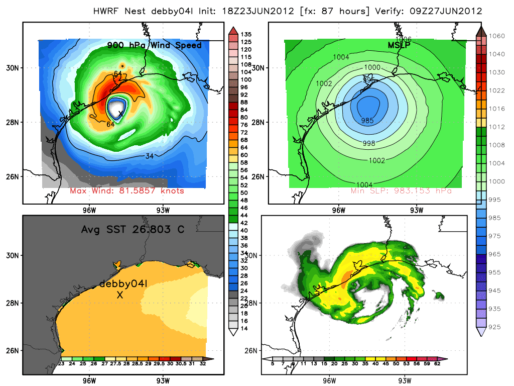
18z HWRF -
-
Andrew
- Site Admin

- Posts: 3440
- Joined: Wed Feb 03, 2010 9:46 pm
- Location: North-West Houston
- Contact:
There isn't really any intense convection to draw in the center. Right now everything keeps getting sheared but as the ULL moves to the southwest it should allow for more stacking. The LLC is pretty defined just doesn't have any convection over it. It is possible though it could relocate time will tell.Rip76 wrote:I just do not see how that center doesn't relocate to the NE.
For Your Infinite Source For All Things Weather Visit Our Facebook
-
Katdaddy
- Global Moderator
- Posts: 2502
- Joined: Thu Feb 04, 2010 8:18 am
- Location: League City, Tx
- Contact:
This is what Joe B posted on Twitter. He agrees with the NHC path and hope he is wrong with the intensity being a CAT2/3 at landfall between Corpus Christi and Matagorda Bay. The Upper TX Coast would get significant effects should this materialize.

Katdaddy wrote:This is what Joe B posted on Twitter. He agrees with the NHC path and hope he is wrong with the intensity being a CAT2/3 at landfall between Corpus Christi and Matagorda Bay. The Upper TX Coast would get significant effects should this materialize.
Was'nt he buying into the eastward solution a few days ago.
-
Katdaddy
- Global Moderator
- Posts: 2502
- Joined: Thu Feb 04, 2010 8:18 am
- Location: League City, Tx
- Contact:
Yes he was totally thus I had to post. Find it interesting that for once he is on the side of the NHC. Of course I hope he is completely wrong. Usually way over hypes tropical event. He is however very good with long range pattern recognitions.
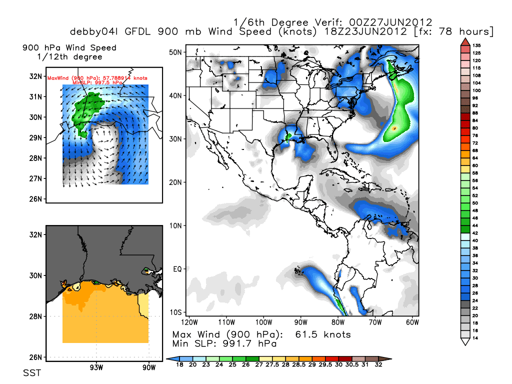
18z GFDL has changed and is inline with most of the other models. Approaches Grand Isle before turning W and hugging the coast.
-
srainhoutx

- Site Admin
- Posts: 19616
- Joined: Tue Feb 02, 2010 2:32 pm
- Location: Maggie Valley, NC
- Contact:
NHC 7:00 PM Advisory: Stationary slight decrease in pressure to 1000mb.
Carla/Alicia/Jerry(In The Eye)/Michelle/Charley/Ivan/Dennis/Katrina/Rita/Wilma/Humberto/Ike/Harvey
Member: National Weather Association
Facebook.com/Weather Infinity
Twitter @WeatherInfinity
Member: National Weather Association
Facebook.com/Weather Infinity
Twitter @WeatherInfinity

Katdaddy wrote:Yes he was totally thus I had to post. Find it interesting that for once he is on the side of the NHC. Of course I hope he is completely wrong. Usually way over hypes tropical event. He is however very good with long range pattern recognitions.
Well I hope he is right in long range pattern recognitions. Because Bastardi is forecasting an extremely cold winter this year. Similar to 57-58.
Okay, I know that wasn't about Debby. Just thought I would make that comment.
Blake
Boomer Sooner
Boomer Sooner
Katdaddy wrote:Yes he was totally thus I had to post. Find it interesting that for once he is on the side of the NHC. Of course I hope he is completely wrong. Usually way over hypes tropical event. He is however very good with long range pattern recognitions.
You're right Joe is rarely in line with the NHC,and on occasion over hypes tropical events,but i think he's good meteorologist.
-
David Paul
- Pro Met

- Posts: 41
- Joined: Thu Jun 21, 2012 8:27 am
- Contact:
Both Joe's and the NHC's track would carry a significant flood threat for se Texas. I'm glad we're getting some very dry days in ahead of potential threat.
-
Andrew
- Site Admin
- Posts: 3440
- Joined: Wed Feb 03, 2010 9:46 pm
- Location: North-West Houston
- Contact:
David Paul wrote:Both Joe's and the NHC's track would carry a significant flood threat for se Texas. I'm glad we're getting some very dry days in ahead of potential threat.
Not to mention if it comes in any farther north like the HWRF we could be dealing with more than just flooding. 00z run with recon data should hopefully clear up a few things.
For Your Infinite Source For All Things Weather Visit Our Facebook
So rain seems to be what we're mainly expecting, right. I know it's a long way out, but give the current track.
No rain, no rainbows.

from the models i see, when the storm makes landfall the storm stalls?
-
srainhoutx
- Site Admin
- Posts: 19616
- Joined: Tue Feb 02, 2010 2:32 pm
- Location: Maggie Valley, NC
- Contact:
We will likely see the data from the Hurricane Hunter C-130 in the 00Z suite overnight. No doubt the word is getting out that Debby has formed. I suspect the full package Advisory at 10:00 will be an interesting read. It's good to see our folks back online and thanks for the updates, David and wxman57...
Carla/Alicia/Jerry(In The Eye)/Michelle/Charley/Ivan/Dennis/Katrina/Rita/Wilma/Humberto/Ike/Harvey
Member: National Weather Association
Facebook.com/Weather Infinity
Twitter @WeatherInfinity
Member: National Weather Association
Facebook.com/Weather Infinity
Twitter @WeatherInfinity