
TROPICAL STORM ERNESTO DISCUSSION NUMBER 9
NWS NATIONAL HURRICANE CENTER MIAMI FL AL052012
500 PM AST FRI AUG 03 2012
THE OVERALL STRUCTURE OF ERNESTO HAS BECOME A LITTLE BETTER
ORGANIZED DURING THE PAST SEVERAL HOURS...WITH AN INCREASE IN
BANDING FEATURES AND CENTRAL CONVECTION. HOWEVER...WESTERLY SHEAR
IS STILL APPARENT WITH MOST OF THE SHOWER AND THUNDERSTORM ACTIVITY
EAST OF THE CENTER. THE INITIAL INTENSITY IS HELD AT 45 KT PENDING
THE ARRIVAL OF AN AIR FORCE RESERVE PLANE THIS EVENING. WESTERLY
SHEAR IS FORECAST TO CONTINUE FOR THE NEXT COUPLE OF DAYS...WHICH
COULD IMPEDE STRENGTHENING. THERE REMAINS A LARGE DIVERGENCE IN
THE INTENSITY GUIDANCE...WITH THE GFS AND ECMWF BASICALLY
DISSIPATING THE SYSTEM AND THE STATISTICAL MODELS SHOWING ERNESTO
BECOMING A HURRICANE IN A COUPLE DAYS. THE NHC INTENSITY FORECAST
REMAINS NEAR THE INTENSITY CONSENSUS...AND IS CLOSE TO THE PREVIOUS
PREDICTION. NEEDLESS TO SAY...THIS IS AN UNCERTAIN FORECAST.
ERNESTO CONTINUES TO MOVE TOWARD THE WEST OR 275/18. THERE IS NO
CHANGE TO THE SYNOPTIC REASONING FROM THE PREVIOUS FORECAST AS THE
CYCLONE REMAINS EMBEDDED WITHIN A FAST EASTERLY FLOW SOUTH OF THE
SUBTROPICAL RIDGE. THIS STEERING PATTERN SHOULD KEEP THE CYCLONE ON
A GENERAL WESTWARD TRACK FOR THE NEXT COUPLE OF DAYS. AFTER
THAT...THE RIDGE WILL PROBABLY WEAKEN SOMEWHAT...CAUSING ERNESTO TO
SLOW DOWN AND GAIN A LITTLE LATITUDE. HOWEVER...TRACK MODELS HAVE
A LARGE SPREAD IN THE LONG TERM WITH LARGE DIFFERENCES IN THE
STRENGTH OF THE RIDGE. THE OFFICIAL FORECAST IS NUDGED TO THE
WEST...AND LIES ON THE SOUTH SIDE OF THE MODEL CONSENSUS. ALTHOUGH
THE NHC FORECAST IS WELL TO THE NORTH OF THE NORMALLY RELIABLE GFS
AND ECMWF MODELS...THESE MODELS ARE SHOWING A RATHER WEAK SYSTEM IN
A FEW DAYS...AND ARE NOT THOUGHT TO BE THE MOST REPRESENTATIVE IN
THIS CASE.
FORECAST POSITIONS AND MAX WINDS
INIT 03/2100Z 13.9N 64.1W 45 KT 50 MPH
12H 04/0600Z 14.2N 66.7W 45 KT 50 MPH
24H 04/1800Z 14.7N 69.9W 50 KT 60 MPH
36H 05/0600Z 15.3N 73.2W 50 KT 60 MPH
48H 05/1800Z 15.9N 76.5W 55 KT 65 MPH
72H 06/1800Z 17.0N 81.0W 65 KT 75 MPH
96H 07/1800Z 19.0N 84.5W 75 KT 85 MPH
120H 08/1800Z 21.0N 88.0W 65 KT 75 MPH...INLAND
$$
FORECASTER BLAKE
Ernesto Dissipates Over Mexico
-
srainhoutx

- Site Admin

- Posts: 19616
- Joined: Tue Feb 02, 2010 2:32 pm
- Location: Maggie Valley, NC
- Contact:
- Attachments
-
Carla/Alicia/Jerry(In The Eye)/Michelle/Charley/Ivan/Dennis/Katrina/Rita/Wilma/Humberto/Ike/Harvey
Member: National Weather Association
Facebook.com/Weather Infinity
Twitter @WeatherInfinity
Member: National Weather Association
Facebook.com/Weather Infinity
Twitter @WeatherInfinity


We already have a forum for the "disturbance" East of Florida and models are picking up on it. Go here for further updates on that storm:JasonFontaine wrote:How are the models picking up Ernesto - and show nothing of 91L?
Seriously - sorry - I am new and curious how this work itself out? While the models are indeed not perfect - shouldn't they sniff it out? Thanks -
http://forums.khou.com/viewtopic.php?f= ... 065#p36065
Blake
Boomer Sooner
Boomer Sooner
-
Andrew
- Site Admin
- Posts: 3440
- Joined: Wed Feb 03, 2010 9:46 pm
- Location: North-West Houston
- Contact:
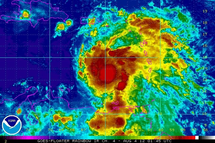
All signs point to a more organized system currently:
http://www.ssd.noaa.gov/PS/TROP/floater ... -long.html
http://www.ssd.noaa.gov/PS/TROP/floater ... -long.html
For Your Infinite Source For All Things Weather Visit Our Facebook
-
weatherguy425
- Pro Met

- Posts: 830
- Joined: Wed Feb 03, 2010 7:45 pm
- Location: Atlanta, Georgia
- Contact:
Andrew wrote:All signs point to a more organized system currently:
http://www.ssd.noaa.gov/PS/TROP/floater ... -long.html
Certainly appears to be the case with a CDO developing/expanding as well as better "ventilation" noted in 3 out of the four quadrants now. What I think is interesting is the growth in overall size that Ernesto has appeared to have. May not end up being quite as small of a system as first appeared I guess.
-
srainhoutx
- Site Admin
- Posts: 19616
- Joined: Tue Feb 02, 2010 2:32 pm
- Location: Maggie Valley, NC
- Contact:
RECON has arrived and is sampling Ernesto at this time. It certainly looks more impressive than it has during its life cycle to date...
- Attachments
-
Carla/Alicia/Jerry(In The Eye)/Michelle/Charley/Ivan/Dennis/Katrina/Rita/Wilma/Humberto/Ike/Harvey
Member: National Weather Association
Facebook.com/Weather Infinity
Twitter @WeatherInfinity
Member: National Weather Association
Facebook.com/Weather Infinity
Twitter @WeatherInfinity
-
Andrew
- Site Admin
- Posts: 3440
- Joined: Wed Feb 03, 2010 9:46 pm
- Location: North-West Houston
- Contact:
weatherguy425 wrote:Andrew wrote:All signs point to a more organized system currently:
http://www.ssd.noaa.gov/PS/TROP/floater ... -long.html
Certainly appears to be the case with a CDO developing/expanding as well as better "ventilation" noted in 3 out of the four quadrants now. What I think is interesting is the growth in overall size that Ernesto has appeared to have. May not end up being quite as small of a system as first appeared I guess.
The constant bubbling of convection is also a good sign. I have been keeping a good eye on MIMIC and the spin-up is really looking good now. If this thing can slow down a little and convection continues to burst over the LLC then it could really going.
Microwave from srain looks impressive also.
For Your Infinite Source For All Things Weather Visit Our Facebook

I don't see too many factors ahead of Ernesto that would prevent this from becoming a Hurricane. I'm with the NHC on this one .... I think they have this nailed so far. It'll be an interesting week next week for sure.
~~~When Thunder Roars Go Indoors~~~
~~~Turn Around Don't Drown~~~
~~~Run From The Water, Hide From The Wind~~~
~~~Turn Around Don't Drown~~~
~~~Run From The Water, Hide From The Wind~~~
Ernesto is throwing up some big & cold cloud tops. Looking better by the hour.
-
Andrew
- Site Admin
- Posts: 3440
- Joined: Wed Feb 03, 2010 9:46 pm
- Location: North-West Houston
- Contact:
Dry air and shear are ahead of it in the Caribbean. Tomorrow will be the true deciding day for how much it affects it.djjordan wrote:I don't see too many factors ahead of Ernesto that would prevent this from becoming a Hurricane. I'm with the NHC on this one .... I think they have this nailed so far. It'll be an interesting week next week for sure.
For Your Infinite Source For All Things Weather Visit Our Facebook

Big blow up the past few hours..lets see if it holds.
GFDL 18Z still north
HWRF 18Z kinda the same as the NHC path but turns it even more NW at the end...scary for us if it verified
GFDL 18Z still north
HWRF 18Z kinda the same as the NHC path but turns it even more NW at the end...scary for us if it verified
the dry air shows up well on this loop
http://www.ssd.noaa.gov/PS/TROP/TCFP/da ... _vapor.gif
too large to embed
http://www.ssd.noaa.gov/PS/TROP/TCFP/da ... _vapor.gif
too large to embed
-
srainhoutx
- Site Admin
- Posts: 19616
- Joined: Tue Feb 02, 2010 2:32 pm
- Location: Maggie Valley, NC
- Contact:
The 00Z Track and Intensity guidance is converging on a Cozumel/Cancun solution while the Intensity guidance is creeping closer to a potential Major Hurricane Status. We will see.
Carla/Alicia/Jerry(In The Eye)/Michelle/Charley/Ivan/Dennis/Katrina/Rita/Wilma/Humberto/Ike/Harvey
Member: National Weather Association
Facebook.com/Weather Infinity
Twitter @WeatherInfinity
Member: National Weather Association
Facebook.com/Weather Infinity
Twitter @WeatherInfinity

Ernie's looking good.http://i131.photobucket.com/albums/p284 ... ab880e.jpg
Ernesto is looking really healthy tonight. I expect a 60mph storm here in a few minutes when we get the advisory. My biggest concern with this storm is the deep warm water in the NW Caribbean that Ernesto is going to go right over. I wouldn't call this a Wilma situation by any means, but it certainly needs to be watched very carefully as it could undergo some rapid intensification when it enters in the NW Caribbean.
Also, the low near Florida could be a huge player in where this storm goes ...which could mean bad news for us as it could draw Ernesto NW into the Central Gulf, then start moving WNW. We'll see...
Also, the low near Florida could be a huge player in where this storm goes ...which could mean bad news for us as it could draw Ernesto NW into the Central Gulf, then start moving WNW. We'll see...
Blake
Boomer Sooner
Boomer Sooner
Still a Tropical Storm with winds still at 50mph. Has slowed down a little bit at 18mph moving West.
Also, track is more northward, not good for us:
This raises my eyebrow in the discussion:
BASED ON THE PREMISE THAT ERNESTO WILL BE FAR
ENOUGH NORTH AND STRONG ENOUGH TO RESPOND TO THE WEAKNESS...THE
LATTER PART OF THE NEW FORECAST TRACK IS NUDGED A LITTLE TO THE
NORTH OF THE PREVIOUS FORECAST.
Also, track is more northward, not good for us:
This raises my eyebrow in the discussion:
BASED ON THE PREMISE THAT ERNESTO WILL BE FAR
ENOUGH NORTH AND STRONG ENOUGH TO RESPOND TO THE WEAKNESS...THE
LATTER PART OF THE NEW FORECAST TRACK IS NUDGED A LITTLE TO THE
NORTH OF THE PREVIOUS FORECAST.
Blake
Boomer Sooner
Boomer Sooner
That caught my attention, too.Belmer wrote:BASED ON THE PREMISE THAT ERNESTO WILL BE FAR
ENOUGH NORTH AND STRONG ENOUGH TO RESPOND TO THE WEAKNESS...THE
LATTER PART OF THE NEW FORECAST TRACK IS NUDGED A LITTLE TO THE
NORTH OF THE PREVIOUS FORECAST.

I haven't been this concerned about a storm since Ike.
jasons wrote:I haven't been this concerned about a storm since Ike.
I'm the same way. I mean, Ike concerned me terribly, but this storm I think has me more concerned. Why? Man, those waters in the NW Caribbean could really make this storm intensify into a Major Hurricane. Even though the forecast track only goes out five days, if you were to continue that track ...say seven days - the center would look to be in the Houston area. Also, IF this system decides to make a visit to the upper TX coast, the way it looks like right now, it will hit Friday night into early Saturday morning ....just like Ike.
This is going to be a LONG week. Not just because of this storm, but this is my last week of summer school here in San Marcos, and I have a HUGE final exam on Thursday morning. After the exam, I will be coming home back to Pasadena. ....Welcome home Blake. I've been gone for two months working my butt off, and I might be coming home to board up my windows. I see many sleepless nights ahead.
Blake
Boomer Sooner
Boomer Sooner
-
TexasBreeze
- Posts: 942
- Joined: Sun Sep 26, 2010 4:46 pm
- Location: NW Houston, TX
- Contact:
It sounds like with a weakness/trough developing in the eastern gulf and U.S. that it would end up being like the last gulf storm and be pulled up well east of TX. Wait and see.
Last edited by TexasBreeze on Fri Aug 03, 2012 10:25 pm, edited 1 time in total.
-
weatherguy425
- Pro Met
- Posts: 830
- Joined: Wed Feb 03, 2010 7:45 pm
- Location: Atlanta, Georgia
- Contact:
Belmer wrote:jasons wrote:I haven't been this concerned about a storm since Ike.
I'm the same way. I mean, Ike concerned me terribly, but this storm I think has me more concerned. Why? Man, those waters in the NW Caribbean could really make this storm intensify into a Major Hurricane. Even though the forecast track only goes out five days, if you were to continue that track ...say seven days - the center would look to be in the Houston area. Also, IF this system decides to make a visit to the upper TX coast, the way it looks like right now, it will hit Friday night into early Saturday morning ....just like Ike.
This is going to be a LONG week. Not just because of this storm, but this is my last week of summer school here in San Marcos, and I have a HUGE final exam on Thursday morning. After the exam, I will be coming home back to Pasadena. ....Welcome home Blake. I've been gone for two months working my butt off, and I might be coming home to board up my windows. I see many sleepless nights ahead.
Don't get me wrong;this is definitely a storm to watch. But I also think it has a chance to creep east of us as well. this weakness will be prevalent pretty much over the entire northern Gulf coast (unless Bermuda high edges westward which is possible) and the stronger it gets, the more poleward it would likely travel. Still a lot of time for things to evolve.