

TROPICAL WEATHER OUTLOOK
NWS NATIONAL HURRICANE CENTER MIAMI FL
800 PM EDT SUN AUG 11 2013
FOR THE NORTH ATLANTIC...CARIBBEAN SEA AND THE GULF OF MEXICO...
TROPICAL CYCLONE FORMATION IS NOT EXPECTED DURING THE NEXT 48 HOURS.
OTHER SYSTEMS WITH FORMATION POTENTIAL BEYOND 48 HOURS...
AN AREA OF LOW PRESSURE IS EXPECTED TO FORM ACROSS THE NORTHWESTERN
CARIBBEAN SEA OR THE SOUTHERN GULF OF MEXICO BY THURSDAY OR
FRIDAY...AND ENVIRONMENTAL CONDITIONS ARE FORECAST TO BECOME
SOMEWHAT CONDUCIVE FOR DEVELOPMENT DURING THAT TIME. THIS SYSTEM
HAS A LOW CHANCE...NEAR 0 PERCENT...OF BECOMING A TROPICAL CYCLONE
DURING THE NEXT 48 HOURS...AND A LOW CHANCE...20 PERCENT...OF
BECOMING A TROPICAL CYCLONE DURING THE NEXT 5 DAYS.
N. ATL Hurricane Season 2013 Discussions
-
Paul Robison
Look at this:
Area forecast discussion
National Weather Service New Orleans la
350 PM CDT sun Aug 11 2013
Short term...
rich tropical moisture activating on typical Gulf Breeze today
with steady motions to the north around 10 knots or so. Much of
this activity will be dissipating shortly after sunset.
Persistence appears in play for Monday with little change in air
mass under the influence of Bermuda ridge flow at the surface.
Temperatures will be near normal levels through Tuesday.
Long term...
weather pattern becomes quite atypical middle of the week heading
into the weekend. Trough amplification over the eastern United
States carves a weakness down the lower Mississippi Valley that
ultimately brings a surface cool front to the Gulf Coast
Wednesday. Upper ridge pattern to the west over the plains states
and Desert Southwest will establish a channel of vorticity lobes
dropping into the base of the trough during the latter half of the
week for an unsettled weather regime. This out of season pattern
will be quite conducive for efficient rains and a flood potential
with a slow moving frontal zone in the presence of tropical
moisture. The GFS is the model of choice through at least
Thursday but gets interesting for the weekend. It is the only
conventional model currently indicating a tropical cyclone
potentially developing over the Yucatan the moves into the central
Gulf states next Saturday. While not totally buying off whole-
hog...teleconnections would suggest a weakness in the flow will
create a vulnerability for the area should a surface low develop
over the central Gulf of Mexico.
The TAFB unit...who prepares the
wind grids for the outer Gulf waters...is in consensus of at least
indicating a cyclonic circulation in the wind field to skirt the
outer coastal waters next Saturday. Will indicate likewise for now
but subsequent model runs will have to be monitored closely.
Incidently...that would be the anniversary of hurricane Camille of
1969...just saying.
Survey question:
Will we see a powerful TC roar ashore in the Houston area this weekend?
Please vote yes or no.
-
Paul Robison
Wow! Normally texas-happy CMC model shunts TC toward LA/MIS!

Still, let's not take it for granted, okay?
Still, let's not take it for granted, okay?
-
Texas Pirate
To Paul R: YOU ASKED:
Survey question:
Will we see a powerful TC roar ashore in the Houston area this weekend?
Please vote yes or no.
Paul I say NO...I think that trough will pull it more NORTH focusing its "eye" (if one does develop)
EAST OF NOLA...that's my vote.
NO Houston.
Wishcasters may now go crazy.
Survey question:
Will we see a powerful TC roar ashore in the Houston area this weekend?
Please vote yes or no.
Paul I say NO...I think that trough will pull it more NORTH focusing its "eye" (if one does develop)
EAST OF NOLA...that's my vote.
NO Houston.
Wishcasters may now go crazy.
-
Paul Robison
Texas Pirate wrote:To Paul R: YOU ASKED:
Survey question:
Will we see a powerful TC roar ashore in the Houston area this weekend?
Please vote yes or no.
Paul I say NO...I think that trough will pull it more NORTH focusing its "eye" (if one does develop)
EAST OF NOLA...that's my vote.
NO Houston.
Wishcasters may now go crazy.
Dear Texas pirate:
This is a SURVEY QUESTION not a PANIC QUESTION. I appreciate your vote and thank you. Now, based on the data and forecast discussions I've observed, I vote NO myself.
My vote is (I don't know).We have several days before we can possibly get any model consensus.

There are a lot of ensemble members from various global models in the BOC. Much of the Gulf is in play at the moment from a system that is still 4-5 days from forming. The "new" forecasting...or trying to decide where a system will landfall and how strong 120 hours before it even forms.
-
Texas Pirate
From the Houston NWS today August 12th morning disco
LASTLY THE GFS IS TRYING TO DEVELOP A TROPICAL LOW PRESSURE IN
THE NW CARIB ON THUR AND MOVES IT INTO INTO THE GULF FRI/SAT.
GIVEN UPPER LEVEL PATTERN THAT DEVELOPS OVER THE N GULF FOR THE
WEEKEND...SHOULD ANYTHING DEVELOP TROPICALLY IT WILL BE IN A
HIGHLY SHEARED ENVIRONMENT. UPPER LEVEL TROUGH WILL ALSO LIKELY
TAKE THE SYSTEM WELL EAST OF THE AREA TOWARDS FL PANHANDLE ON
SUNDAY. THIS WILL BE SOMETHING TO KEEP AN EYE ON BUT OVERALL NOT
MUCH OF A CONCERN.
-
Paul Robison
Watching the storm system in the Caribbean
Author: Bill Read, KPRC Local 2 Hurricane Expert
Published On: Aug 12 2013 10:54:22 AM
.
HOUSTON -
I’m following a rather disorganized area of showers and thunderstorms over the eastern and central Caribbean Sea Monday morning for possible development later this week.
A tropical wave in the eastern Caribbean is moving west at about 15 mph. There is currently no low pressure center associated with this disturbance and wind shear Monday, and likely Tuesday, should keep the system disorganized.
However, by Wednesday, the wave will have reached the very warm waters of northwest Caribbean east of the Yucatan Peninsula and north of Honduras while models forecast the wind shear to lessen.
The National Hurricane Center gives this disturbance a 20 percent chance of developing into a depression or tropical storm over the next five days. We’ll be watching for possible storm development in that area by Thursday.
Forecasting where a storm will track before it has even formed is fraught with error. However, all the models are forecasting a high pressure ridge building aloft over Texas and northern Mexico Monday then moving west toward the end of the week while a strong trough of low pressure extends southward through the Mississippi Valley to the northern Gulf.
This pattern would suggest that whatever moves out of the northwest Caribbean Thursday or Friday will either be steered north through the eastern Gulf by the trough or due west across the Yucatan and Bay of Campeche into Mexico by the ridge. Both cases are away from southeast Texas.
Stay tuned!
In other words, not all that great a concern for us, (Brownsville, though, now that's another story) but watch it all the same, right?
-
Texas Pirate
Hi Paul
I think Mr Read hit it on the head with this statement for us in SE TX:
Both cases are away from southeast Texas.
And yes, all year round we need to be prepared. Preparedness isn't just for cane season.
Got a couple of days to go and for us, a no-go. Would love to get some nice rain without a name, though
-
vci_guy2003
- Posts: 203
- Joined: Mon Jun 28, 2010 4:04 am
- Contact:
at this rate all forecasts are gonna bust for the season

FWIW,
It is now Invest 92L.
It is now Invest 92L.
FWIW we also have invest 93L
My name is Nicole and I love weather!!
~~~~~~~~~~~~~~~~~~~~~~~~~~~~~~~~~~~~~~~~~~~~~~~~~~~~~~~~~~~~~~~~~~~~~~~~~~~~~~~~~~~~~~~~~~~~~~~~
Alicia, Allison, Rita, Ike
~~~~~~~~~~~~~~~~~~~~~~~~~~~~~~~~~~~~~~~~~~~~~~~~~~~~~~~~~~~~~~~~~~~~~~~~~~~~~~~~~~~~~~~~~~~~~~~~
Alicia, Allison, Rita, Ike
-
TexasBreeze
- Posts: 942
- Joined: Sun Sep 26, 2010 4:46 pm
- Location: NW Houston, TX
- Contact:
I'm starting to find it hard to believe there will be 18 named systems during the next 3 months. it would have to ramp up and keep real busy constantly during that time. There have been 4 so far though so it's possible.
This may not be our year for for a system. The high is either on us or to the west which blocks Texas and the trough in the east too. The pattern is locked in. IMO.
This may not be our year for for a system. The high is either on us or to the west which blocks Texas and the trough in the east too. The pattern is locked in. IMO.

As of now there are two invests 92L and now 93L out in the Atlantic. Not sure if they will ever make it to a named storms but the tropics seem to be showing signs of life.
-
Texas Pirate
I truly believe its an EAST of Texas cane summer anyway.
Fine by me, I just want an inch or two of rain, with no drama involved.
Fine by me, I just want an inch or two of rain, with no drama involved.
-
srainhoutx

- Site Admin

- Posts: 19616
- Joined: Tue Feb 02, 2010 2:32 pm
- Location: Maggie Valley, NC
- Contact:
^^
92 L discussions are on the Main Page August thread, Ed.
92 L discussions are on the Main Page August thread, Ed.
Carla/Alicia/Jerry(In The Eye)/Michelle/Charley/Ivan/Dennis/Katrina/Rita/Wilma/Humberto/Ike/Harvey
Member: National Weather Association
Facebook.com/Weather Infinity
Twitter @WeatherInfinity
Member: National Weather Association
Facebook.com/Weather Infinity
Twitter @WeatherInfinity
000
AXNT20 KNHC 171149
TWDAT
TROPICAL WEATHER DISCUSSION
NWS NATIONAL HURRICANE CENTER MIAMI FL
805 AM EDT SAT AUG 17 2013
TROPICAL WEATHER DISCUSSION FOR NORTH AMERICA...CENTRAL
AMERICA...GULF OF MEXICO...CARIBBEAN SEA...NORTHERN SECTIONS OF
SOUTH AMERICA...AND ATLANTIC OCEAN TO THE AFRICAN COAST FROM THE
EQUATOR TO 32N. THE FOLLOWING INFORMATION IS BASED ON SATELLITE
IMAGERY...WEATHER OBSERVATIONS...RADAR...AND METEOROLOGICAL
ANALYSIS.
BASED ON 0600 UTC SURFACE ANALYSIS AND SATELLITE IMAGERY THROUGH
1015 UTC.
...SPECIAL FEATURES...
TROPICAL STORM ERIN IS CENTERED NEAR 18.9N 35.6W AT 17/0900 UTC
OR ABOUT 690 NM W-NW OF THE CAPE VERDE ISLANDS MOVING W-NW AT 13
KT. ESTIMATED MINIMUM CENTRAL PRESSURE IS 1006 MB. MAXIMUM
SUSTAINED WIND SPEED IS 35 KT WITH GUST TO 45 KT. PLEASE SEE
LATEST NHC INTERMEDIATE PUBLIC ADVISORY UNDER AWIPS/WMO HEADERS
MIATCPAT5/WTNT35 AND THE FULL FORECAST/ADVISORY UNDER AWIPS/WMO
HEADERS MIATCMAT5/WTNT25 KNHC FOR MORE DETAILS. THE CONVECTION
IS N OF THE EXPESED LOW LEVEL CENTER THIS MORNING. SCATTERED
MODERATE/ISOLATED STRONG CONVECTION IS FROM 19N-23N BETWEEN 33W-
36W.
THE SURFACE TROUGH IN THE GULF OF MEXICO EXTENDS FROM 26N90W
THROUGH A WEAK 1010 MB LOW NEAR 21N93W TO S MEXICO NEAR 17N94W.
A MID/UPPER LOW IS TO THE NE NEAR 22N90W. AN UPPER RIDGE IS
ANCHORED IN THE YUCATAN CHANNEL EXTENDING AN AXIS E OF THE LOWS
THROUGH THE GULF TO ACROSS S/CENTRAL FLORIDA DRAWING THE
MOISTURE AND SHOWER/THUNDERSTORM ACTIVITY NE OF THE LOW LEVEL
SYSTEM. SCATTERED SHOWERS/ISOLATED THUNDERSTORMS ARE WITHIN 120
NM OF LINE FROM OVER S MEXICO NEAR 18N93W ALONG 26N87W TO OVER
NE FLORIDA NEAR 30N83W. ENVIRONMENTAL CONDITIONS COULD BECOME
SOMEWHAT MORE FAVORABLE FOR DEVELOPMENT WHILE THE LOW GENERALLY
MOVES TOWARD THE WEST-NORTHWEST OR NORTHWEST OVER THE NEXT
COUPLE OF DAYS. INTERESTS IN THE CENTRAL AND WESTERN GULF OF
MEXICO SHOULD MONITOR THE PROGRESS OF THE SYSTEM THROUGH EARLY
NEXT WEEK. THIS SYSTEM HAS A MEDIUM CHANCE OF BECOMING A
TROPICAL CYCLONE DURING THE NEXT 48 HOURS...AND A MEDIUM
CHANCE OF BECOMING A TROPICAL CYCLONE DURING THE NEXT 5 DAYS.
...TROPICAL WAVES...
TROPICAL WAVE IN THE E TROPICAL WAVE EXTENDS FROM 22N56W TO
10N56W MOVING W 15-20 KT. WAVE REMAINS EMBEDDED WITHIN AN AREA
OF MODERATE MOISTURE AS DEPICTED IN TOTAL PRECIPITABLE WATER
IMAGERY. NO ASSOCIATED SHOWERS OR DEEP CONVECTION.
TROPICAL WAVE IS MOVING ACROSS THE CARIBBEAN EXTENDS FROM 22N70W
TO 13N71W MOVING W NEAR 20 KT. PORTION OF THE WAVE N OF 16N IS
EMBEDDED WITHIN AN AREA OF DEEP MOISTURE COVERING THE AREA FROM
PUERTO RICO TO THE DOMINICAN REPUBLIC AS DEPICTED IN TOTAL
PRECIPITABLE WATER IMAGERY. SCATTERED SHOWERS AND POSSIBLE
ISOLATED THUNDERSTORMS DOT THE AREA FROM 15N-21N BETWEEN 64W-75W
INCLUDING THE VIRGIN ISLANDS...PUERTO RICO...AND HISPANIOLA.
...ITCZ/MONSOON TROUGH...
THE MONSOON TROUGH EXTENDS ACROSS AFRICA INTO THE E TROPICAL
ATLC NEAR 12N15W CONTINUING ALONG 9N20W TO 10N27W THEN RESUMES
SW OF T.S. ERIN NEAR 13N41W TO A WEAK 1012 MB LOW NEAR 12N46W.
THE ITCZ BEGINS W OF THE LOW NEAR 12N48W AND CONTINUES ALONG
11N55W TO SOUTH AMERICA NEAR 8N59W. SCATTERED MODERATE/ISOLATED
STRONG CONVECTION IS FROM 5N-10N BETWEEN 14W-22W. CLUSTERS OF
SCATTERED MODERATE/ISOLATED STRONG CONVECTION ARE FROM 6N-13N
BETWEEN 40W-52W.
...DISCUSSION...
GULF OF MEXICO...
MOST OF THE ACTIVITY OVER E GULF IS ASSOCIATED WITH THE SURFACE
TROUGH/LOW IN THE SW GULF. SEE SPECIAL FEATURES ABOVE. AN UPPER
TROUGH COVERS THE E CONUS EXTENDING FROM AN UPPER LOW OVER THE
MIDDLE MISSISSIPPI VALLEY TO S TEXAS AND SUPPORTING A STATIONARY
BOUNDARY THAT MEANDERS ALONG THE GULF COAST FROM SW GEORGIA INTO
THE GULF NEAR PENSACOLA TO A WEAK 1014 MB LOW JUST W OF NEW
ORLEANS THEN RE-EMERGING INTO THE GULF OVER ATCHAFALAYA BAY
LOUISIANA TO NEAR GALVESTON TEXAS. SCATTERED SHOWERS/ISOLATED
THUNDERSTORMS ARE WITHIN 60 NM S OF THE FRONT E OF 93W. AN UPPER
RIDGE IS ANCHORED IN THE YUCATAN CHANNEL EXTENDING AN AXIS OVER
THE E GULF ALONG 26N85W TO ACROSS S/CENTRAL FLORIDA INTO THE W
ATLC DRAWING MOISTURE AND SUBSEQUENT SHOWERS/THUNDERSTORMS OVER
THE E GULF...ASSOCIATED WITH THE SYSTEM IN THE SPECIAL FEATURES
ABOVE. WEAK SURFACE RIDGE EXTENDS FROM THE W ATLC ACROSS CENTRAL
FLORIDA TO OVER THE E GULF. LOW PRESSURE SYSTEM IN SPECIAL
FEATURES IS FORECAST TO CONTINUE TO MOVE IN A W-NW DIRECTION
REACHING THE W/CENTRAL GULF LATE SUN THEN MOVING INLAND OVER
EXTREME SE TEXAS COAST LATE MON...WITH THE POSSIBILITY OF
TROPICAL CYCLONE FORMATION THROUGH MON. SURFACE RIDGE WILL
DOMINATE THE REMAINDER OF THE GULF THROUGH WED.
CARIBBEAN SEA...
THE UPPER RIDGE OVER THE E GULF OF MEXICO IS ANCHORED IN THE
YUCATAN CHANNEL AND COVERS THE FAR NW CARIBBEAN W OF 83W WHILE A
SECOND UPPER RIDGE COVERS THE E CARIBBEAN ANCHORED JUST E OF THE
LEEWARD ISLANDS. THIS IS INDUCING AN INVERTED UPPER TROUGH OVER
THE CENTRAL CARIBBEAN EXTENDING FROM COSTA RICA/PANAMA BORDER
ACROSS JAMAICA AND E CUBA. CLUSTERS OF SCATTERED SHOWERS/
ISOLATED THUNDERSTORMS ARE FROM 17N-22N BETWEEN 75W-83W. THE
MONSOON TROUGH EXTENDS ALONG 10N FROM COLOMBIA TO COSTA RICA
GENERATING SCATTERED SHOWERS/ISOLATED THUNDERSTORMS S OF 12N W
OF 77W TO INLAND OVER PANAMA TO NICARAGUA. THE SHOWER ACTIVITY
IN THE N/CENTRAL CARIBBEAN IS ASSOCIATED WITH THE TROPICAL WAVE.
SCATTERED SHOWERS/ISOLATED THUNDERSTORMS ARE APPROACHING THE
LEEWARD AND VIRGIN ISLANDS WITHIN 60 NM OF LINE FROM 18N61W TO
20N64W. THE REMAINDER OF THE CARIBBEAN IS UNDER FAIR CONDITIONS
AGAIN THIS MORNING. CARIBBEAN TROPICAL WAVE WILL CONTINUE W
THROUGH THE CENTRAL CARIBBEAN TODAY BECOMING DIFFUSE OVER THE W
CARIBBEAN ON SUN. A SECOND TROPICAL WAVE WILL MOVE ACROSS THE E
CARIBBEAN ON SUN AND MON AND THROUGH THE CENTRAL CARIBBEAN TUE
AND WED.
HISPANIOLA...
SCATTERED SHOWERS ARE POSSIBLE ISOLATED THUNDERSTORMS CONTINUE
ACROSS THE ISLAND THIS MORNING. THE TROPICAL WAVE THAT IS
GENERATING THESE SHOWERS WILL CONTINUE TO MOVE ACROSS THE
DOMINICAN REPUBLIC TO OVER HAITI TODAY BRINGING THESE SHOWERS
AND POSSIBLE MORE ISOLATED THUNDERSTORMS THROUGHOUT THE DAY.
ANOTHER WAVE WILL MOVE ACROSS THE ISLAND LATE SUN THROUGH TUE
INCREASING THE POSSIBILITY OF HEAVIER OR MORE FREQUENT
SHOWERS/THUNDERSTORMS.
ATLANTIC OCEAN...
THE UPPER RIDGE OVER THE W CARIBBEAN EXTENDS ACROSS THE GULF OF
MEXICO INTO THE W ATLC NEAR MELBOURNE FLORIDA TO BEYOND 32N70W.
THE UPPER TROUGH OVER THE E CONUS AND THE ASSOCIATED STATIONARY
FRONT IS N OF THE DISCUSSION AREA WITH SCATTERED SHOWERS/
ISOLATED THUNDERSTORMS N OF 29N W OF 76W. A BROAD SURFACE RIDGE
DOMINATES THE REMAINDER OF THE ATLC INTO THE GULF OF MEXICO
ANCHORED BY A SERIES OF HIGHS N OF THE DISCUSSION AREA. A WEAK
UPPER LOW IS IN THE CENTRAL ATLC NEAR 26N48W GENERATING
SCATTERED SHOWERS/ISOLATED THUNDERSTORMS FROM 27N-32N BETWEEN
47W-54W. SURFACE RIDGE EXTENDING INTO THE GULF OF MEXICO WILL
LIFT IN N TO NEAR 31N TODAY AND SUN AND SHIFT N OF THE AREA NEXT
WEEK. THE N PORTION OF CARIBBEAN TROPICAL WAVE WILL MOVE ACROSS
THE FAR SW ATLC THROUGH SUN NIGHT.
FOR ADDITIONAL INFORMATION PLEASE VISIT
http://WWW.HURRICANES.GOV/MARINE
$$
PAW
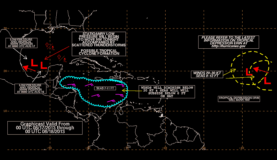
Ed,
I just came here to post about that little blob that the Fla. Keys coughed up.
I don't see much, but it is August so something to watch. It appears that blob is really crusin' though.
I just came here to post about that little blob that the Fla. Keys coughed up.
I don't see much, but it is August so something to watch. It appears that blob is really crusin' though.
-
wxman57

- Global Moderator

- Posts: 2621
- Joined: Thu Feb 04, 2010 5:34 am
- Location: Southwest Houston (Westbury)
- Contact:
Something to at least keep an eye on, Ed. Alicia formed from a blob of storms similar to that back in 1983. Pressure at the buoy to its north is falling, though still 1015mb or more.