
Tropical Remnant Chantal: In The Bahamas
-
srainhoutx

- Site Admin

- Posts: 19616
- Joined: Tue Feb 02, 2010 2:32 pm
- Location: Maggie Valley, NC
- Contact:
95L has been designated about 800 miles SW of the Cape Verde Islands.
- Attachments
-
Carla/Alicia/Jerry(In The Eye)/Michelle/Charley/Ivan/Dennis/Katrina/Rita/Wilma/Humberto/Ike/Harvey
Member: National Weather Association
Facebook.com/Weather Infinity
Twitter @WeatherInfinity
Member: National Weather Association
Facebook.com/Weather Infinity
Twitter @WeatherInfinity

-
srainhoutx
- Site Admin
- Posts: 19616
- Joined: Tue Feb 02, 2010 2:32 pm
- Location: Maggie Valley, NC
- Contact:
TROPICAL WEATHER OUTLOOK
NWS NATIONAL HURRICANE CENTER MIAMI FL
200 PM EDT SAT JUL 6 2013
FOR THE NORTH ATLANTIC...CARIBBEAN SEA AND THE GULF OF MEXICO...
A VIGOROUS TROPICAL WAVE IS LOCATED OVER THE EASTERN ATLANTIC ABOUT
850 MILES SOUTHWEST OF THE CAPE VERDE ISLANDS. ASSOCIATED SHOWER
AND THUNDERSTORM ACTIVITY IS SHOWING SIGNS OF IMPROVED ORGANIZATION
AND ENVIRONMENTAL CONDITIONS ARE EXPECTED TO GRADUALLY BECOME MORE
CONDUCIVE FOR DEVELOPMENT OVER THE NEXT FEW DAYS. THIS SYSTEM HAS A
MEDIUM CHANCE...30 PERCENT...OF BECOMING A TROPICAL CYCLONE DURING
THE NEXT 48 HOURS AS IT MOVES WESTWARD AT 20 TO 25 MPH.
Carla/Alicia/Jerry(In The Eye)/Michelle/Charley/Ivan/Dennis/Katrina/Rita/Wilma/Humberto/Ike/Harvey
Member: National Weather Association
Facebook.com/Weather Infinity
Twitter @WeatherInfinity
Member: National Weather Association
Facebook.com/Weather Infinity
Twitter @WeatherInfinity
-
srainhoutx
- Site Admin
- Posts: 19616
- Joined: Tue Feb 02, 2010 2:32 pm
- Location: Maggie Valley, NC
- Contact:
There is some buzz about 95L that is currently racing across the Central Atlantic at about 25 MPH. This is awfully fast for a wave to travel and it would need to slow its forward motion before any real development can be expected. There is a chance after it enters the Caribbean Sea next weekend and approaches the NW Caribbean conditions become a bit more conducive for development. The ensembles are suggesting a rather potent 500mb upper low near the Northern Gulf Coast at that time, but a lot of caution is recommended as we know how wrong the longer range guidance can be. Some features that are favorable for development later on is the MJO and the relaxing of the easterly trade winds the closer any wave makes it to the Western Caribbean. I do believe we will have a couple of weeks of increased tropical wave activity before we see a bit of relaxation and an up tick in activity again as we enter August time frame beyond mid month into the peak season of early September.
- Attachments
-
Carla/Alicia/Jerry(In The Eye)/Michelle/Charley/Ivan/Dennis/Katrina/Rita/Wilma/Humberto/Ike/Harvey
Member: National Weather Association
Facebook.com/Weather Infinity
Twitter @WeatherInfinity
Member: National Weather Association
Facebook.com/Weather Infinity
Twitter @WeatherInfinity
-
srainhoutx
- Site Admin
- Posts: 19616
- Joined: Tue Feb 02, 2010 2:32 pm
- Location: Maggie Valley, NC
- Contact:
TROPICAL WEATHER OUTLOOK
NWS NATIONAL HURRICANE CENTER MIAMI FL
200 PM EDT SUN JUL 7 2013
FOR THE NORTH ATLANTIC...CARIBBEAN SEA AND THE GULF OF MEXICO...
A STRONG TROPICAL WAVE LOCATED ABOUT 1150 MILES EAST-SOUTHEAST OF
THE WINDWARD ISLANDS IS MOVING WESTWARD AT 25 MPH. SHOWER AND
THUNDERSTORM ACTIVITY CONTINUES TO SHOW SIGNS OF ORGANIZATION...
AND RECENT SATELLITE WIND DATA INDICATE THAT A CLOSED SURFACE
CIRCULATION MAY BE FORMING. ENVIRONMENTAL CONDITIONS ARE CONDUCIVE
FOR FURTHER DEVELOPMENT OF THIS DISTURBANCE...AND A TROPICAL
DEPRESSION OR A TROPICAL STORM COULD FORM AT ANY TIME...WHICH WOULD
REQUIRE A TROPICAL STORM WATCH OR WARNING FOR PORTIONS OF THE
LESSER ANTILLES. THIS SYSTEM HAS A HIGH CHANCE...60 PERCENT...OF
BECOMING A TROPICAL CYCLONE DURING THE NEXT 48 HOURS.
ELSEWHERE...TROPICAL CYCLONE FORMATION IS NOT EXPECTED DURING THE
NEXT 48 HOURS.
$$
FORECASTER STEWART
Carla/Alicia/Jerry(In The Eye)/Michelle/Charley/Ivan/Dennis/Katrina/Rita/Wilma/Humberto/Ike/Harvey
Member: National Weather Association
Facebook.com/Weather Infinity
Twitter @WeatherInfinity
Member: National Weather Association
Facebook.com/Weather Infinity
Twitter @WeatherInfinity
-
TexasBreeze
- Posts: 942
- Joined: Sun Sep 26, 2010 4:46 pm
- Location: NW Houston, TX
- Contact:
It's Tropical Storm Chantal now. 40 mph winds. Moves wnw northern Carribbean turns nw by Cuba.

If it takes that path and continues in that direction, would it be a Florida storm if it survived? Speculation, yes.TexasBreeze wrote:It's Tropical Storm Chantal now. 40 mph winds. Moves wnw northern Carribbean turns nw by Cuba.
-
TexasBreeze
- Posts: 942
- Joined: Sun Sep 26, 2010 4:46 pm
- Location: NW Houston, TX
- Contact:
Florida or just to the east. NHC.
-
TexasBreeze
- Posts: 942
- Joined: Sun Sep 26, 2010 4:46 pm
- Location: NW Houston, TX
- Contact:
Yup the very quick movement it has plus the typically hostile eastern Carribbean could do it in quickly.
-
srainhoutx
- Site Admin
- Posts: 19616
- Joined: Tue Feb 02, 2010 2:32 pm
- Location: Maggie Valley, NC
- Contact:
I just see much happening for Chantal until it slows its forward motion.
Carla/Alicia/Jerry(In The Eye)/Michelle/Charley/Ivan/Dennis/Katrina/Rita/Wilma/Humberto/Ike/Harvey
Member: National Weather Association
Facebook.com/Weather Infinity
Twitter @WeatherInfinity
Member: National Weather Association
Facebook.com/Weather Infinity
Twitter @WeatherInfinity
-
srainhoutx
- Site Admin
- Posts: 19616
- Joined: Tue Feb 02, 2010 2:32 pm
- Location: Maggie Valley, NC
- Contact:
E-mail from Jeff regarding Chantal:
Third tropical storm of the Atlantic 2013 hurricane season forms in the deep tropics.
Tropical Storm Warnings are in effect for many of the Windward Islands.
Discussion:
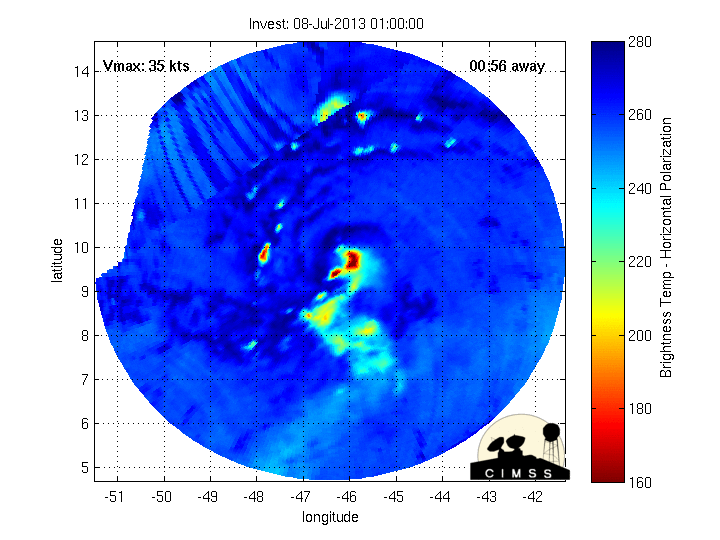
The strong tropical wave that emerged off the African coast late last week has gradually become better organized and has enough deep convection and appears to have a closed low level circulation to be declared a tropical cyclone. It is rare for tropical system to develop this far east this early in the season and while conditions are not overly favorable for development the system has held its own fairly well against several negative factors. Chantal is currently located 700 miles ESE of the Windward Islands and is racing W at 26mph. Visible and IR images show deep convective bursts near and to the south of what is likely a center of circulation on the N and NE edges of the deep convection. Chantal is surrounded by dry air and dust from Africa, but this appears to only be modestly affecting the system. A recon. Aircraft will be flown today to check the intensity and structure of the system.
Track:
The tropical storm is south of deep layer mid-level ridging over the Atlantic and is tracking rapidly westward under its influence within the easterly trades. This very fast motion is expected to continue if not increase some in the next 24-36 hours and it may be very hard for Chantal to keep a well-defined closed center moving at this rate of speed. On this track, Chantal will cross the Windward Islands early Tuesday and enter into the eastern Caribbean Sea. By Day 3 (Thursday) Chantal will be nearing the island of Hispaniola and the western edge of the sub-tropical high over the SW Atlantic. A deep layer trough over the SE US is forecast to develop in a pattern very similar to what just happen last week over the US with strong blocking high pressure over the W Atlantic, a very deep SE US trough, and blocking high pressure over the W US. The pattern offers a weakness for Chantal to turn more NW and NNW into the Bahamas as it feels the influence of the SE US trough. There is much greater spread in the forecast track guidance beyond Day 3 as to how quickly the upper pattern over the US begins to retro-grade (more westward) and where Chantal will be located at that time. Some of the latest guidance is indicating western Atlantic ridging building westward and blocking Chantal from turning northward and instead attempt to bend the system back WNW or W toward the SE US or FL. The other option on the table is that Chantal is unable to maintain a closed circulation and degenerates into an open wave and tracks more westward in the Caribbean Sea. It should be noted that both the GFS and ECMWF only have a very weak reflection of the system and the ECMWF shows little to no development. Systems moving at this rate of speed and into the eastern Caribbean Sea usually struggle.
Intensity:
While the system looks healthy on satellite images, data from the plane today will confirm what the internal structure of the system really is. As mentioned, it can be hard for tropical cyclones moving this quickly to maintain a closed off center. Chantal is also approaching the eastern Caribbean Sea where developing tropical systems tend to struggle. While some of the guidance indicates Chantal will make a 45-55kt tropical storm over the Caribbean Sea…The most trusted of the models do not show much overall intensification of the system and this is likely a factor of the fast forward motion which will create wind shear over the system. Toward Day 3, Chantal may interact with the higher terrain of Cuba or Haiti and nearly all guidance shows weakening before the system emerges over the southern Bahamas. Intensity in the longer ranges will be determined by how much interaction Chantal has with the trough over the SE US if Chantal is still a tropical system at that point.
NHC Forecast Track and Error Cone:
Third tropical storm of the Atlantic 2013 hurricane season forms in the deep tropics.
Tropical Storm Warnings are in effect for many of the Windward Islands.
Discussion:
The strong tropical wave that emerged off the African coast late last week has gradually become better organized and has enough deep convection and appears to have a closed low level circulation to be declared a tropical cyclone. It is rare for tropical system to develop this far east this early in the season and while conditions are not overly favorable for development the system has held its own fairly well against several negative factors. Chantal is currently located 700 miles ESE of the Windward Islands and is racing W at 26mph. Visible and IR images show deep convective bursts near and to the south of what is likely a center of circulation on the N and NE edges of the deep convection. Chantal is surrounded by dry air and dust from Africa, but this appears to only be modestly affecting the system. A recon. Aircraft will be flown today to check the intensity and structure of the system.
Track:
The tropical storm is south of deep layer mid-level ridging over the Atlantic and is tracking rapidly westward under its influence within the easterly trades. This very fast motion is expected to continue if not increase some in the next 24-36 hours and it may be very hard for Chantal to keep a well-defined closed center moving at this rate of speed. On this track, Chantal will cross the Windward Islands early Tuesday and enter into the eastern Caribbean Sea. By Day 3 (Thursday) Chantal will be nearing the island of Hispaniola and the western edge of the sub-tropical high over the SW Atlantic. A deep layer trough over the SE US is forecast to develop in a pattern very similar to what just happen last week over the US with strong blocking high pressure over the W Atlantic, a very deep SE US trough, and blocking high pressure over the W US. The pattern offers a weakness for Chantal to turn more NW and NNW into the Bahamas as it feels the influence of the SE US trough. There is much greater spread in the forecast track guidance beyond Day 3 as to how quickly the upper pattern over the US begins to retro-grade (more westward) and where Chantal will be located at that time. Some of the latest guidance is indicating western Atlantic ridging building westward and blocking Chantal from turning northward and instead attempt to bend the system back WNW or W toward the SE US or FL. The other option on the table is that Chantal is unable to maintain a closed circulation and degenerates into an open wave and tracks more westward in the Caribbean Sea. It should be noted that both the GFS and ECMWF only have a very weak reflection of the system and the ECMWF shows little to no development. Systems moving at this rate of speed and into the eastern Caribbean Sea usually struggle.
Intensity:
While the system looks healthy on satellite images, data from the plane today will confirm what the internal structure of the system really is. As mentioned, it can be hard for tropical cyclones moving this quickly to maintain a closed off center. Chantal is also approaching the eastern Caribbean Sea where developing tropical systems tend to struggle. While some of the guidance indicates Chantal will make a 45-55kt tropical storm over the Caribbean Sea…The most trusted of the models do not show much overall intensification of the system and this is likely a factor of the fast forward motion which will create wind shear over the system. Toward Day 3, Chantal may interact with the higher terrain of Cuba or Haiti and nearly all guidance shows weakening before the system emerges over the southern Bahamas. Intensity in the longer ranges will be determined by how much interaction Chantal has with the trough over the SE US if Chantal is still a tropical system at that point.
NHC Forecast Track and Error Cone:
- Attachments
-
- 07082013 Jeff image001.gif (34.78 KiB) Viewed 4824 times
-
Carla/Alicia/Jerry(In The Eye)/Michelle/Charley/Ivan/Dennis/Katrina/Rita/Wilma/Humberto/Ike/Harvey
Member: National Weather Association
Facebook.com/Weather Infinity
Twitter @WeatherInfinity
Member: National Weather Association
Facebook.com/Weather Infinity
Twitter @WeatherInfinity
-
Andrew
- Site Admin
- Posts: 3440
- Joined: Wed Feb 03, 2010 9:46 pm
- Location: North-West Houston
- Contact:
ridging does look to strengthen somewhat in the northern atlantic but shear does look pretty strong in the gulf around that time especially with the cutoff racing west. Would be hard for any development *if* it even made it in the gulf.
For Your Infinite Source For All Things Weather Visit Our Facebook

Note: that many models develop the next wave behind Chantal. Early season development in this region is likely an ominous foreshadowing of what is to come out of the deep tropics this season.
-
TexasBreeze
- Posts: 942
- Joined: Sun Sep 26, 2010 4:46 pm
- Location: NW Houston, TX
- Contact:
It's 7/8 and already the wave train is beginning to roll. One behind Chantal that Jeff noted, one behind that too on Africa's coast looks good.

my daughter is in Orlando (Disney World) for her Senior Vacation and is due to fly home Sunday morning...Not liking that cone.
-
srainhoutx
- Site Admin
- Posts: 19616
- Joined: Tue Feb 02, 2010 2:32 pm
- Location: Maggie Valley, NC
- Contact:
Morning e-mail from Jeff:
Chantal nearing the Windward Islands with tropical storm conditions likely over the next 12 hours.
Discussion:
The tropical storm this morning looks less organized than 24 hours ago with a general lack of banding features and only modest convection. In fact up until recently the convection had really weakened, but in the last few hours a new ball of storms has developed very near what was an exposed low level center. Dry air is lurking to the west and north of Chantal and it is likely that some of this is being ingested into the circulation and minimizing thunderstorm activity on the NW side of the system. In addition the continued fast forward motion is causing the low level center to “outrun” the thunderstorms and preventing the tropical cyclone from becoming vertically stacked. I do not see much change in these factors over the next 24-36 hours and although model guidance all supports some intensification, the environmental factors are marginal.
Track:
Guidance remains in fairly good agreement that Chantal will continue on a WNW course on the south side of the sub-tropical high over the central Atlantic through late Wednesday. This will bring the tropical storm to the southern coast of the mountainous island of Hispaniola and then across the island Wednesday night into Thursday. Thereafter, a deepening trough of low pressure over the SE US in response to building high pressure over the western US into the central plains will cause Chantal to turn toward the NNW into the Bahamas and slow its forward speed. This trough over the SE US is forecast to develop into a closed upper level low and begin to (retro-grade) or move westward as strong blocking high pressure builds west from the Atlantic. This blocking high looks to prevent Chantal from continuing northward but instead slows the storm and most guidance shows a turn back toward the west as high pressure builds into the US east coast. Where Chantal is located and how quickly the upper air pattern evolves will determine where and when the tropical system makes a turn toward the US coast. At this time the spread in the latter part of the forecast track is fairly large and the uncertainty is high given the above mentioned factors. Additionally, there is some suggestion that Hispaniola will greatly weaken the system and this is very possible.
Intensity:
Chantal is facing some hurdles this morning with the biggest being the upcoming interaction with the mountains of Hispaniola. Current dry air to the west and north of the circulation is likely getting entrained into the inner core and disrupting internal convection and the fast forward motion continues to hinder development. May see a slight increase in intensity prior to landfall over Hispaniola, but not much and would not expect the system to surpass about 50kts. As mentioned, it is to be seen as to how Chantal emerges from a track over Hispaniola. Usually mountainous terrain tear the low level center apart and it is possible the Chantal may weaken into a depression or even an open wave while crossing the island, or could maintain tropical storm status. Once over the Bahamas conditions look a bit more favorable than yesterday for some develop, but much of this depends on where Chantal will be in relation to the upper trough over the SE US. It is possible that Chantal may be far enough removed that the upper level outflow on the SE side of the trough actually helps intensify the system as suggested by the latest GFDL hurricane model run. On the other hand, if Chantal falls under the shearing influences of the trough it would likely struggle. There is a fairly large spread in the intensity guidance by 96 hours with the NHC forecast on the lower end of nearly all the guidance. The GFDL and SHIPS guidance make Chantal a hurricane while the GFS is a tropical storm and the ECMWF still does not keep a closed system.
[/i]
Chantal nearing the Windward Islands with tropical storm conditions likely over the next 12 hours.
Discussion:
The tropical storm this morning looks less organized than 24 hours ago with a general lack of banding features and only modest convection. In fact up until recently the convection had really weakened, but in the last few hours a new ball of storms has developed very near what was an exposed low level center. Dry air is lurking to the west and north of Chantal and it is likely that some of this is being ingested into the circulation and minimizing thunderstorm activity on the NW side of the system. In addition the continued fast forward motion is causing the low level center to “outrun” the thunderstorms and preventing the tropical cyclone from becoming vertically stacked. I do not see much change in these factors over the next 24-36 hours and although model guidance all supports some intensification, the environmental factors are marginal.
Track:
Guidance remains in fairly good agreement that Chantal will continue on a WNW course on the south side of the sub-tropical high over the central Atlantic through late Wednesday. This will bring the tropical storm to the southern coast of the mountainous island of Hispaniola and then across the island Wednesday night into Thursday. Thereafter, a deepening trough of low pressure over the SE US in response to building high pressure over the western US into the central plains will cause Chantal to turn toward the NNW into the Bahamas and slow its forward speed. This trough over the SE US is forecast to develop into a closed upper level low and begin to (retro-grade) or move westward as strong blocking high pressure builds west from the Atlantic. This blocking high looks to prevent Chantal from continuing northward but instead slows the storm and most guidance shows a turn back toward the west as high pressure builds into the US east coast. Where Chantal is located and how quickly the upper air pattern evolves will determine where and when the tropical system makes a turn toward the US coast. At this time the spread in the latter part of the forecast track is fairly large and the uncertainty is high given the above mentioned factors. Additionally, there is some suggestion that Hispaniola will greatly weaken the system and this is very possible.
Intensity:
Chantal is facing some hurdles this morning with the biggest being the upcoming interaction with the mountains of Hispaniola. Current dry air to the west and north of the circulation is likely getting entrained into the inner core and disrupting internal convection and the fast forward motion continues to hinder development. May see a slight increase in intensity prior to landfall over Hispaniola, but not much and would not expect the system to surpass about 50kts. As mentioned, it is to be seen as to how Chantal emerges from a track over Hispaniola. Usually mountainous terrain tear the low level center apart and it is possible the Chantal may weaken into a depression or even an open wave while crossing the island, or could maintain tropical storm status. Once over the Bahamas conditions look a bit more favorable than yesterday for some develop, but much of this depends on where Chantal will be in relation to the upper trough over the SE US. It is possible that Chantal may be far enough removed that the upper level outflow on the SE side of the trough actually helps intensify the system as suggested by the latest GFDL hurricane model run. On the other hand, if Chantal falls under the shearing influences of the trough it would likely struggle. There is a fairly large spread in the intensity guidance by 96 hours with the NHC forecast on the lower end of nearly all the guidance. The GFDL and SHIPS guidance make Chantal a hurricane while the GFS is a tropical storm and the ECMWF still does not keep a closed system.
Carla/Alicia/Jerry(In The Eye)/Michelle/Charley/Ivan/Dennis/Katrina/Rita/Wilma/Humberto/Ike/Harvey
Member: National Weather Association
Facebook.com/Weather Infinity
Twitter @WeatherInfinity
Member: National Weather Association
Facebook.com/Weather Infinity
Twitter @WeatherInfinity
recon found some hurricane force winds at the surface a little while ago, but may be contaminated reading. very odd little storm.
-
srainhoutx
- Site Admin
- Posts: 19616
- Joined: Tue Feb 02, 2010 2:32 pm
- Location: Maggie Valley, NC
- Contact:
Product: Air Force Vortex Message (URNT12 KNHC)
Transmitted: 9th day of the month at 14:29Z
Aircraft: Air Force Aircraft (Last 3 digits of the tail number are 302)
Storm Number & Year: 03L in 2013
Storm Name: Chantal (flight in the North Atlantic basin)
Mission Number: 2
Observation Number: 10
A. Time of Center Fix: 9th day of the month at 14:10:40Z
B. Center Fix Coordinates: 14°18'N 61°13'W (14.3N 61.2167W)
B. Center Fix Location: 23 miles (37 km) to the SSW (204°) from Fort-de-France, Martinique (FRA).
C. Minimum Height at Standard Level: Not Available
D. Estimated (by SFMR or visually) Maximum Surface Wind: 40kts (~ 46.0mph)
E. Location of the Estimated Maximum Surface Wind: 32 nautical miles (37 statute miles) to the NW (319°) of center fix
F. Maximum Flight Level Wind Inbound: From 65° at 53kts (From the ENE at ~ 61.0mph)
G. Location of Maximum Flight Level Wind Inbound: 36 nautical miles (41 statute miles) to the NW (321°) of center fix
H. Minimum Sea Level Pressure: 1008mb (29.77 inHg) - Extrapolated
I. Maximum Flight Level Temp & Pressure Altitude Outside Eye: 20°C (68°F) at a pressure alt. of 364m (1,194ft)
J. Maximum Flight Level Temp & Pressure Altitude Inside Eye: 23°C (73°F) at a pressure alt. of 361m (1,184ft)
K. Dewpoint Temp (collected at same location as temp inside eye): 23°C (73°F)
K. Sea Surface Temp (collected at same location as temp inside eye): Not Available
L. Eye Character: No Observation
M. Eye Shape: Not Available
N. Fix Determined By: Penetration, Radar, Wind, Pressure and Temperature
N. Fix Level: 1,500 feet
O. Navigational Fix Accuracy: 0.02 nautical miles
O. Meteorological Accuracy: 2 nautical miles
Remarks Section - Remarks That Were Decoded...
Maximum Flight Level Wind: 75kts (~ 86.3mph) which was observed 45 nautical miles (52 statute miles) to the NE (35°) from the flight level center at 13:43:30Z
Sea Level Pressure Extrapolation From: Below 1,500 feet
Remarks Section - Additional Remarks...
SPIRAL BAND 16NM ACROSS, 75KTS AT 850MB LEVEL
Carla/Alicia/Jerry(In The Eye)/Michelle/Charley/Ivan/Dennis/Katrina/Rita/Wilma/Humberto/Ike/Harvey
Member: National Weather Association
Facebook.com/Weather Infinity
Twitter @WeatherInfinity
Member: National Weather Association
Facebook.com/Weather Infinity
Twitter @WeatherInfinity
-
tireman4

- Global Moderator

- Posts: 4488
- Joined: Wed Feb 03, 2010 9:24 pm
- Location: Humble, Texas
- Contact:
I thought this little snippet from the NHC was interesting...
THE GUIDANCE ENVELOPE SHIFTED WESTWARD IN THE LAST
RUN AND CONSEQUENTLY...THE OFFICIAL FORECAST WAS ADJUSTED IN THAT
DIRECTION...BUT NOT AS FAR AS THE MODEL CONSENSUS. IF THIS WESTWARD
MODEL TREND CONTINUES IN THE NEXT CYCLE...I WILL NOT BE SURPRISED
IF ANOTHER WESTWARD SHIFT WILL BE REQUIRED.
Humm.. Interesting days ahead watching this...