
August - Warm and Dry Weather Returns To End The Month
-
redneckweather
- Posts: 1023
- Joined: Mon Feb 08, 2010 7:29 pm
- Location: Montgomery, Texas
- Contact:
As we head into August, it looks like it will be hot n dry. As Srain pointed out, the tropics might start to get active as the month wears on. Discuss away!
-
TexasBreeze
- Posts: 942
- Joined: Sun Sep 26, 2010 4:46 pm
- Location: NW Houston, TX
- Contact:
Any signs in the models of any pattern change with our high pressure?

Only thing I know it is getting horribly dry at my house since I got no rainfall in July. No real break in the ridging for the near term and even the long term...maybe some seabreeze stuff this weekend, but that is so hit and miss and I know I will be on the miss side of that.
Pattern just keeps repeating itself and locking in too close to the upper level ridge. Cant even get a cumulus cloud today which is sad in July! Tropics will be of no help with ridge parking near/over TX and trough along the east coast. Atlantic development would be likely recurved east of the Gulf and if something did get going in the Gulf...it would probably head for Mexico...similar to the past few years. Maybe in 2 weeks it will all change...we can at least hope!
Pattern just keeps repeating itself and locking in too close to the upper level ridge. Cant even get a cumulus cloud today which is sad in July! Tropics will be of no help with ridge parking near/over TX and trough along the east coast. Atlantic development would be likely recurved east of the Gulf and if something did get going in the Gulf...it would probably head for Mexico...similar to the past few years. Maybe in 2 weeks it will all change...we can at least hope!
-
srainhoutx

- Site Admin

- Posts: 19616
- Joined: Tue Feb 02, 2010 2:32 pm
- Location: Maggie Valley, NC
- Contact:
Morning e-mail from Jeff:
Ridge of upper level high pressure is in firm control of the weather and will result in hot and dry conditions through the rest of this week. Could see an isolated thunderstorm along the seabreeze front this weekend if Gulf moisture is able to increase and the ridge aloft backs to the west some.
Recent rainfall in July was spotty and not all locations benefitted from rainfall while other locations picked up several inches. SE TX has been is some form of drought nearly this entire year and drought conditions have been prevalent since the aftermath of Hurricane Ike now nearly 5 years ago. The entire state continues to suffer through dry conditions with significant impacts on water supply across central and west TX where the impacts of the 2011 drought remain. All of SE TX is covered by severe drought conditions with areas of extreme drought noted southwest of College Station and across portions of our coastal counties.
Rainfall Deficits for 2013:
BUSH IAH: -9.39
Hobby: -7.78
College Station: -3.30
Galveston: -5.50
Angleton: -15.00
Palacios: -14.15
Tomball: -9.25
Conroe: -4.59
Huntsville: -4.64
League City: -7.62
Note: BUSH IAH has recorded 17.62 inches of rainfall thus far in 2013 (through 7-21-13).
If you sum up the rainfall departures for BUSH IAH from Jan 1, 2009 to July 21, 2013 a staggering rainfall deficit of 51.85 inches is found. Put in another way in the last 4.5 years over an entire year’s worth of rainfall is “missing”. The average rainfall for BUSH IAH is 49.77 inches. Below is the rainfall and deficits for BUSH IAH going back to 2009:
2009: 47.01 in (-2.76 in)
2010: 42.72 in (-7.05 in)
2011: 24.57 in (-25.20 in)
2012: 42.32 in (-7.45 in)
2013: 17.87 in (-9.39 in) though 7-21
Vegetation Health/Fire Weather:
Even with the recent rainfall, extremely dry conditions exists across much of the area. KBDI values range from 600-700 across nearly all of Brazoria, Fort Bend, Brazos, Grimes, Washington, Burleson, and northern Austin counties. A few spots in Brazoria County are over 700. The scale runs from (0 completely saturated to 800 completely dry to a depth of 8 inches). Values over 600-700 typically support extreme fire weather conditions and within the last few weeks the number of grass fires has increased especially over Brazoria County. This week a 200+ acre fire developed in Bastrop County near Smithville (now 60% contained), but this indicates the fine and even some larger fuels are starting to dry. Luckily besides some gusty winds in the afternoon hours, wind speeds have been averaging below 15mph and RH recovery has been good in the evening and overnight hours. A total of 119 counties are currently under burn bans including: Galveston, Brazoria, Matagorda, Colorado, Waller, Grimes, Montgomery, Austin, Brazos, and Washington.
Water Supply:
Locally water supply is doing well with most water supply lakes/reservoirs above 90% of capacity. Conditions are much more dire in central TX where severe water supply issues remain.
Current Water Level Departure from Normal Pool:
Lake Conroe: -2.98 ft
Lake Georgetown: -15.54 ft
Sam Rayburn: -4.20 ft
Lake Livingston: -.73 ft
Lake Somerville: -5.40 ft
Lake Travis: -56.40 ft
Lake Buchanan: -29.37 ft
Lake Amistad: -55.94 ft
Lake Mackenzie: -96.07 ft
Outlook:
Little to no significant rainfall appears likely through next week especially away from the coast. Temperatures will continue to run warm, in the upper 90’s to low 100’s. Evaporation rates will remain high and vegetation health will continue to decline. Our only real prospects for widespread wetting rainfall would be some form of tropical system if the massive ridge over NW TX would give a little ground. Long term outlooks suggest drought conditions continuing into October and possibly worsening.
Carla/Alicia/Jerry(In The Eye)/Michelle/Charley/Ivan/Dennis/Katrina/Rita/Wilma/Humberto/Ike/Harvey
Member: National Weather Association
Facebook.com/Weather Infinity
Twitter @WeatherInfinity
Member: National Weather Association
Facebook.com/Weather Infinity
Twitter @WeatherInfinity
-
wxman57

- Global Moderator

- Posts: 2621
- Joined: Thu Feb 04, 2010 5:34 am
- Location: Southwest Houston (Westbury)
- Contact:
Here's the Harris County Flood Control District map with rainfall since Jan. 1 (211 days, not including today). My house is between the SW corner of 610 and the SW corner of Beltway 8 (red X). I've measured just over 23", much of that falling in March (I think) when I recorded over 10" of rain:


That 15.72" amount at the gauge @ I-45 & The Hardy, one of the lowest totals on the map, is just a few miles from me. That looks about right. Jeff's email is not good news as a lot of the trees are reaching their limits again.
-
wxman57
- Global Moderator
- Posts: 2621
- Joined: Thu Feb 04, 2010 5:34 am
- Location: Southwest Houston (Westbury)
- Contact:
Ed,
The Euro is definitely the outlier as far as predictions of higher pressure across the Gulf and Caribbean this summer. Other seasonal models continue to indicate below-normal pressure in these regions.
The Euro is definitely the outlier as far as predictions of higher pressure across the Gulf and Caribbean this summer. Other seasonal models continue to indicate below-normal pressure in these regions.
-
srainhoutx
- Site Admin
- Posts: 19616
- Joined: Tue Feb 02, 2010 2:32 pm
- Location: Maggie Valley, NC
- Contact:
wxman57 wrote:Ed,
The Euro is definitely the outlier as far as predictions of higher pressure across the Gulf and Caribbean this summer. Other seasonal models continue to indicate below-normal pressure in these regions.
I agree. Here is the image I posted on our KHOU Board facebook page of the CFSv2 weeklies for the mid/latter half of August.
- Attachments
-
Carla/Alicia/Jerry(In The Eye)/Michelle/Charley/Ivan/Dennis/Katrina/Rita/Wilma/Humberto/Ike/Harvey
Member: National Weather Association
Facebook.com/Weather Infinity
Twitter @WeatherInfinity
Member: National Weather Association
Facebook.com/Weather Infinity
Twitter @WeatherInfinity

Ahhh ... the doldrums of summer. It would be interesting to see and compare what these past 5 years compare to the 5 years prior to Ike rainfall wise in SE Texas. It seems like we could go east into Louisiana, Mississippi, and Alabama and find plenty of rainfall these past 5 years. It's almost as if somebody shut off the faucet over SE Texas after Ike and it only sprung a few leaks in between then and now LOL.
This sounds like a stat job for our statistician.
This sounds like a stat job for our statistician.
~~~When Thunder Roars Go Indoors~~~
~~~Turn Around Don't Drown~~~
~~~Run From The Water, Hide From The Wind~~~
~~~Turn Around Don't Drown~~~
~~~Run From The Water, Hide From The Wind~~~

Got about an inch of rain Sunday but already the grass is getting that 'water me now" look. Even though my area has received about 26 inches this year most of it was from a few storms that dumped a lot of rain quickly. We need a period of light to moderate rain that lasts for a few days so the rain can actually soak into the ground
My July total was 2.53"
Normal for July is 3.79"
So even after two ULLs parked over us for days and a rare July cold front, I could only muster about 66% or 2/3 or normal in the rain bucket? Seriously?
That's just pathetic. What a sad state of affairs our climate is stuck in.
Normal for July is 3.79"
So even after two ULLs parked over us for days and a rare July cold front, I could only muster about 66% or 2/3 or normal in the rain bucket? Seriously?
That's just pathetic. What a sad state of affairs our climate is stuck in.


There were droughts in Louisiana, Mississippi, and Alabama during the five years prior to Ike. In fact, it was very dry in Alabama when Texas was wet in 2007.djjordan wrote:Ahhh ... the doldrums of summer. It would be interesting to see and compare what these past 5 years compare to the 5 years prior to Ike rainfall wise in SE Texas. It seems like we could go east into Louisiana, Mississippi, and Alabama and find plenty of rainfall these past 5 years. It's almost as if somebody shut off the faucet over SE Texas after Ike and it only sprung a few leaks in between then and now LOL.
This sounds like a stat job for our statistician.
Let's look at annual and summer (June to August) rainfall total prior to Ike for Upper Texas Coast. I will start at 2002.
2002-2007 Annual
2002 61.57
2003 47.42
2004 64.66
2005 38.92
2006 55.51
2007 61.89
2002-2007 Annual Average
54.995 or 55.00
1895-2012 Annual Average
47.42
1895-2012 Annual Median
46.34
1895-2012 Standard Deviation
10.78
2002-2007 Summer
2002 18.19
2003 16.91
2004 17.02
2005 9.94
2006 20.94
2007 24.01
2002-2007 Summer Average
17.835 or 17.84
1895-2012 Summer Average
12.96
1895-2012 Annual Median
12.20
1895-2012 Standard Deviation
5.02
The period from 2002-2007 is wetter than normal. The five years prior to Ike was when the Pacific Decadal Oscillation (PDO) was in a warm phase. PDO went into a cool phase in late 2007. Here is 2008-2012.
2008-2012 Annual
2008 42.30
2009 43.69
2010 45.27
2011 24.06
2012 48.86
2008-2012 Annual Average
40.836 or 40.84
2008-2012 Summer
2008 13.95
2009 5.66
2010 16.91
2011 6.41
2012 15.44
2008-2012 Summer Average
11.674 or 11.67
The period from 2008-2012 is drier than normal. It corresponds with cool PDO phase on top of warm Atlantic Multidecadal Oscillation (AMO). The summer before Ike has normal rainfall total as it is within standard deviation. The only year between 2008 to 2012 with average annual rainfall is 2012. The rest is below average, especially 2011. Most summers between 2008 to 2012 are dry, especially 2009 and 2011. 2009 was wetter due to heavy rains of April and October. Late 2009 went into El Nino, which helped lessened 2009 from being a very dry year.
Data Is From Division Data.
http://www7.ncdc.noaa.gov/CDO/CDODivisionalSelect.jsp
-
srainhoutx
- Site Admin
- Posts: 19616
- Joined: Tue Feb 02, 2010 2:32 pm
- Location: Maggie Valley, NC
- Contact:
As my signature suggests, I've been chased by enough storms in a lifetime.Ed Mahmoud wrote:I was hoping Srain's vacation was well times in the Keys so he could video us a storm. Yes, I know, they'd make him evacuate, but he could still capture excellent cell phone video in mainland Monroe or Miami-Dade.
But his vacation is well timed because the board will be dead.
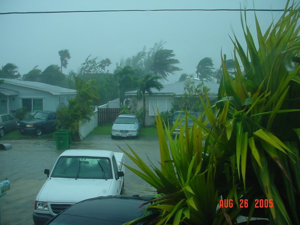
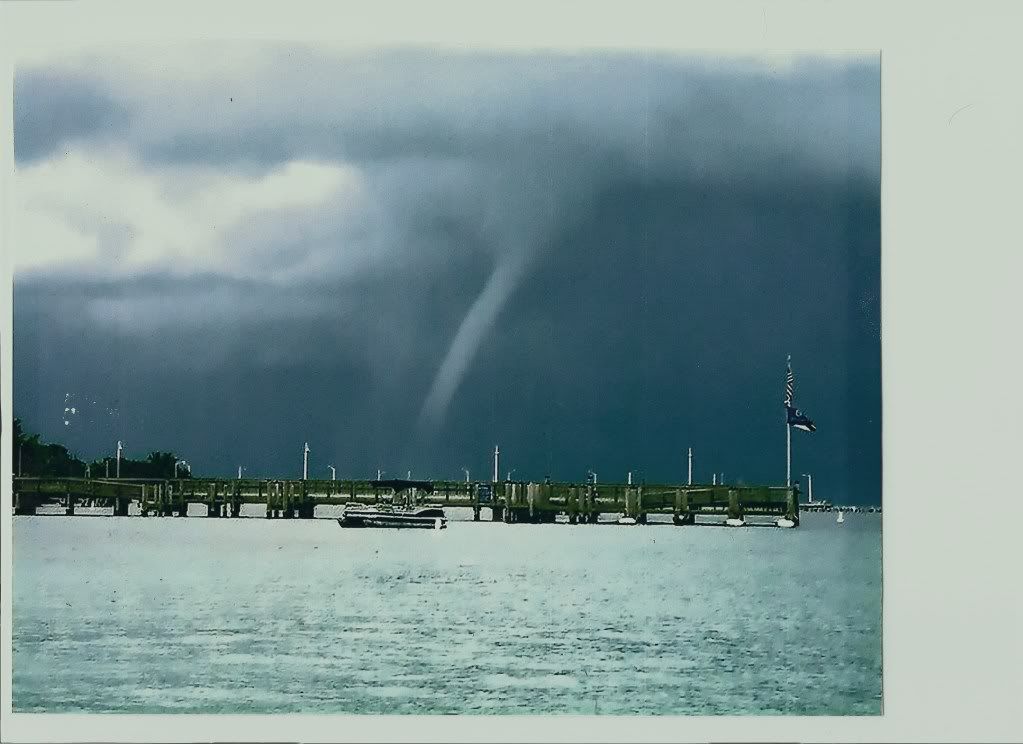
That said I did capture this shot while living there 'back in the day' on the Atlantic side from our boat looking N toward Boca Chica. The Keys are known for producing a lot of water spouts along cloud lines heading toward the Gulf and Florida Bay.
Carla/Alicia/Jerry(In The Eye)/Michelle/Charley/Ivan/Dennis/Katrina/Rita/Wilma/Humberto/Ike/Harvey
Member: National Weather Association
Facebook.com/Weather Infinity
Twitter @WeatherInfinity
Member: National Weather Association
Facebook.com/Weather Infinity
Twitter @WeatherInfinity
The Cockroach Ridge has returned. Need to get cans of RAID to kill it.TexasBreeze wrote:Any signs in the models of any pattern change with our high pressure?
-
srainhoutx
- Site Admin
- Posts: 19616
- Joined: Tue Feb 02, 2010 2:32 pm
- Location: Maggie Valley, NC
- Contact:
Ed Mahmoud wrote:srainhoutx wrote:As my signature suggests, I've been chased by enough storms in a lifetime.Ed Mahmoud wrote:I was hoping Srain's vacation was well times in the Keys so he could video us a storm. Yes, I know, they'd make him evacuate, but he could still capture excellent cell phone video in mainland Monroe or Miami-Dade.
But his vacation is well timed because the board will be dead.
That said I did capture this shot while living there 'back in the day' on the Atlantic side from our boat looking N toward Boca Chica. The Keys are known for producing a lot of water spouts along cloud lines heading toward the Gulf and Florida Bay.
Is that top picture surge or freshwater flooding?[/quote]
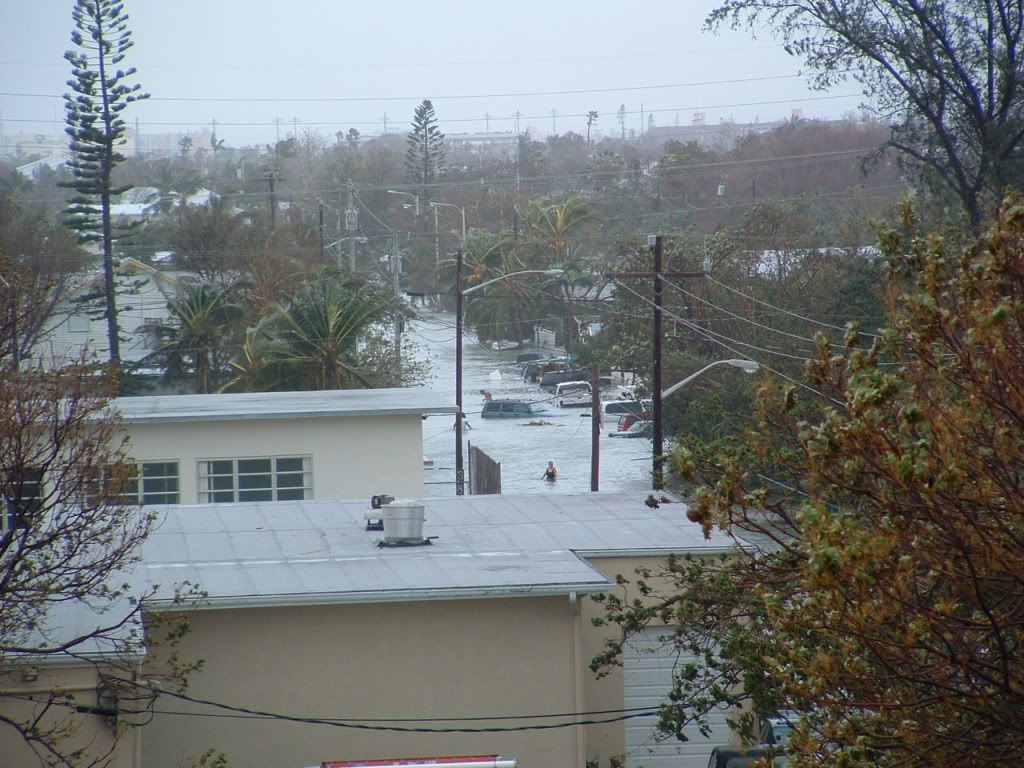
That was a little of both, Ed. That picture was when Katrina was passing just to the N of the Lower Keys in Florida Bay on its way to the Gulf and strengthening to what became a CAT 5. This shot was taken from the roof of the newly constructed NWS EYW Building that was relocated from the airport to an bit more inland location on White Street. What you see here is storm surge that came twice from Wilma as it was rapidly heading ENE. The first surge came from the Atlantic side of the Island about 2:30 AM and the second surge came from the Gulf/Florida Bay side about 7:00 AM as Wilma raced off toward mainland S Florida.

Carla/Alicia/Jerry(In The Eye)/Michelle/Charley/Ivan/Dennis/Katrina/Rita/Wilma/Humberto/Ike/Harvey
Member: National Weather Association
Facebook.com/Weather Infinity
Twitter @WeatherInfinity
Member: National Weather Association
Facebook.com/Weather Infinity
Twitter @WeatherInfinity
-
srainhoutx
- Site Admin
- Posts: 19616
- Joined: Tue Feb 02, 2010 2:32 pm
- Location: Maggie Valley, NC
- Contact:
Maybe...just maybe...the doldrums of lack of weather for our Region may change around mid August. We will see.
- Attachments
-
Carla/Alicia/Jerry(In The Eye)/Michelle/Charley/Ivan/Dennis/Katrina/Rita/Wilma/Humberto/Ike/Harvey
Member: National Weather Association
Facebook.com/Weather Infinity
Twitter @WeatherInfinity
Member: National Weather Association
Facebook.com/Weather Infinity
Twitter @WeatherInfinity
-
robertscottlazar
- Posts: 38
- Joined: Thu Jun 06, 2013 10:56 am
- Contact:
this is a big joke. its too hot and too humid and we dont have enough rainfall. srain has said over and over this isnt a repear of 2011. i beg to differ.
and another thing i dont like is the attempted explanations for the weathing thats going on. ptarmigan comes up with these anomilies and other attempted explanations to explain why we havent been getting the rainfall we need. the fact of the matter is that houston,and most of texas' climate has changed,for whatever reason. it is hotter and drier than it was 15 years ago.
forget the stupid anomilies and attempted explanations. there are things that happen that science doesnt understand and cannot explain. science still cant explain why the ice ages occured. science cannot explain why the earth warmed back up.
remember earth is a tiny ball of rock and gas sitting in the middle of space. the earth is constantly affected by things in space that we cannot see and we do not know about.
the earths climate will do what it wants to do,when it wants to do it. thats my explanation as to why houstons climate has changed
I would hardly say that Houston's climate has changed. The climate of Texas has always been much drier than most in this region would like to admit. We have been very much spoiled over the past 40 years to have had "plenty" of rainfall, but looking back pre 40 years and TX was a dry place with big long term droughts.robertscottlazar wrote:this is a big joke. its too hot and too humid and we dont have enough rainfall. srain has said over and over this isnt a repear of 2011. i beg to differ.
and another thing i dont like is the attempted explanations for the weathing thats going on. ptarmigan comes up with these anomilies and other attempted explanations to explain why we havent been getting the rainfall we need. the fact of the matter is that houston,and most of texas' climate has changed,for whatever reason. it is hotter and drier than it was 15 years ago.
forget the stupid anomilies and attempted explanations. there are things that happen that science doesnt understand and cannot explain. science still cant explain why the ice ages occured. science cannot explain why the earth warmed back up.
remember earth is a tiny ball of rock and gas sitting in the middle of space. the earth is constantly affected by things in space that we cannot see and we do not know about.
the earths climate will do what it wants to do,when it wants to do it. thats my explanation as to why houstons climate has changed
Not saying that the 40 years of wet is over, as there are global factors currently helping to drive the TX dryness and until they change it will continue to be dry in this state unless an El Nino can override the underlying factors in the Pacific and the Atlantic.
-
srainhoutx
- Site Admin
- Posts: 19616
- Joined: Tue Feb 02, 2010 2:32 pm
- Location: Maggie Valley, NC
- Contact:
I definitely agree. You see, I am a 5th generation Texan and I know for a fact the we have been much drier with a couple of multi decade drought events across our Region. My Grand Mother who was born in 1900 and lived through the Dust Bowl Days would tell me that the 20's into the mid 30's were terribly dry across the Lone Star State. The wealth of weather knowledge I gain from her and other relatives before they passed on inspired my interest in weather and encouraged it at a very young age.jeff wrote:
I would hardly say that Houston's climate has changed. The climate of Texas has always been much drier than most in this region would like to admit. We have been very much spoiled over the past 40 years to have had "plenty" of rainfall, but looking back pre 40 years and TX was a dry place with big long term droughts.
Not saying that the 40 years of wet is over, as there are global factors currently helping to drive the TX dryness and until they change it will continue to be dry in this state unless an El Nino can override the underlying factors in the Pacific and the Atlantic.
What some seem to conveniently forget or perhaps never knew is that:
1) Most of our lakes were man made. Lake Houston was a project that the City of Houston undertook in 1953 by damming the E and W forks of the San Jacinto Rivers after purchasing Lake Sheldon which was the primary source for water for the city at that time.
2) All the Hill Country Lakes were Army Corp of Engineer Projects with Canyon Lake and Lake Somerville being the last completed, if I recall correctly.
Coastal Texas has and will always be impacted by tropical storms and Hurricanes. It is folly for to believe that this will change. We are located in a geographical area along the NW Gulf of Mexico Coast that will always be changing, weather wise. The Sierra Madre Oriental Mountains of Mexico have a big affect on our weather such as capping. They always have and they always will.

Now, to say that we are in a long term drought is not correct as this current version of AZ pointed out that I falsely stated when I commented this is not 2011. The facts prove otherwise. Is it dry? certainly we have been, but not on the levels of 2011 and certainly not like the Plains experienced last year in 2012.
Back to the Doldrums of August, that redneckweather rightly named this Topic...for the time being. I do see rather strong indications that this current rather boring pattern has about a week left before the upper ridge shifts W and the Gulf opens up for business. We can already see indications of an inverted trough traveling W across the Gulf by next weekend and that should be the beginning of a bit 'wetter' pattern that develops. The fly in the ointment is tropical activity. As we have been mentioning in our Hurricane Central area of this Weather Forum, there are signals that suggest the tropics are about to awaken across the Caribbean Sea and the Gulf of Mexico as we get to around the August 15th timeframe, +/- a few days. The longer range computer models are already 'sniffing' this change. Does it mean that we will see a land falling tropical system along the Mexico/Texas/Louisiana Coast? Odds are respectfully good that some portion of the Gulf Coast from the Yucatan to Key West will see some impact from a tropical system, or even a Major Hurricane before our 2013 Hurricane Season is said and done. Therefore we watch, wait, monitor and talk on this forum about....of all things, the weather. I'm looking forward to getting back to the Keys and experiencing those beautiful sunsets that SAL (Saharan Air Layer) events bring to that part of the world.

Carla/Alicia/Jerry(In The Eye)/Michelle/Charley/Ivan/Dennis/Katrina/Rita/Wilma/Humberto/Ike/Harvey
Member: National Weather Association
Facebook.com/Weather Infinity
Twitter @WeatherInfinity
Member: National Weather Association
Facebook.com/Weather Infinity
Twitter @WeatherInfinity
After reading that post, I want to move back to Florida now.
My rainfall total so far this year is 15.59"
If I recall correctly, the drought of 2011 was unique in several ways. There were tree ring records that showed there was nothing so severe in over 1,000+ years (1300 IIRC). Trees that had lived hundreds of years, through the prolonged droughts of the 20/30' and 50's, finally succumbed to the heat & lack of rain in 2011. I believe this was unprecedented and could indicate maybe our climate is indeed changing (whether natural or not is another debate; but climate does and will continue to change).
2011 was sad and I was hoping to never see it again. This year is indeed better than that, but tree stress is a cumulative affect, just like heat stress is for humans. They were already stressed from years of excessive heat and dry weather before 2011. This resulted in pine bark beetle outbreaks in late summer. Some areas up here in the piney woods already had 'dead zones' of trees in the years leading-up to 2011. The train tracks along the Hardy Toll road used to have a wall of beautiful pine trees blocking the view; it was wiped-out by beetles in 2009-2010. Then 2011 hit with the tree apocalypse. Last year helped, but they never fully recovered; they are still in a very fragile state.
That's why this year, we started seeing some pines already turn to toast in June. It doesn't have to be as bad as 2011 to cause another big tree loss because the trees are barely holding-on as it is. They really cannot take much more of this.
I think I mentioned a few weeks ago this ancient pine on the corner lot was looking bad - I have taken many sunset shots with that pine as a backdrop. It leaned slightly and there was something unique about its short needles and tall, lanky trunk.
On Thursday, the HOA cut it down. All that's left there now is a giant stump.
-
- Information
-
Who is online
Users browsing this forum: Ahrefs [Bot], Amazon [Bot], Cpv17, Semrush [Bot], TexasBreeze and 53 guests