September: Weekend Rain Chances. 1-2 Inches Possible C/N TX

General Weather Discussions and Analysis
Post Reply
unome
Posts: 3059
Joined: Fri Feb 12, 2010 6:11 pm

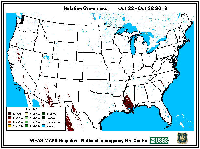
realative greenness map

Image
Ed Mahmoud wrote:Any forestry people? If we're on the dry, windy side of a TS Lee type Louisiana storm, will sparking power lines burn half of Texas East of I-35?

How primed are the trees for more fires this Autumn?


Image
User avatar
Ptarmigan
Statistical Specialist
Posts: 3994
Joined: Wed Feb 03, 2010 7:20 pm
Contact:

Image

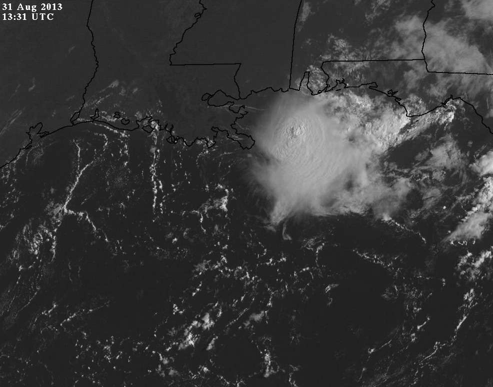
Thunderstorms off the coast of Alabama. If it persists for days, it bears watching.
texoz
Posts: 291
Joined: Tue Mar 02, 2010 8:01 am
Contact:

The early season forecast of a busy tropical season gave some hope to end the drought. The lack of rain in the forecast, and the blistering heat are not boding well for central Texas. It's a near certainty now that this drought continues until later winter, if not longer. Lake levels are approaching record lows. :(
User avatar
Portastorm
Posts: 800
Joined: Wed Feb 03, 2010 3:04 pm
Location: Southwest Austin/Oak Hill, TX
Contact:

That basically sounds like what EWX said in their mid-morning AFD update. Radar shows activity 70 miles and more to our (Austin) northwest and moving southwest. Sadly. Hopeful those scattered showers develop.
User avatar
Katdaddy
Global Moderator
Global Moderator
Posts: 2502
Joined: Thu Feb 04, 2010 8:18 am
Location: League City, Tx
Contact:

SEVERE THUNDERSTORM WARNING
TXC039-201-022230-
/O.NEW.KHGX.SV.W.0129.130902T2202Z-130902T2230Z/

BULLETIN - IMMEDIATE BROADCAST REQUESTED
SEVERE THUNDERSTORM WARNING
NATIONAL WEATHER SERVICE HOUSTON/GALVESTON TX
502 PM CDT MON SEP 2 2013

THE NATIONAL WEATHER SERVICE IN LEAGUE CITY HAS ISSUED A

* SEVERE THUNDERSTORM WARNING FOR...
EXTREME NORTH CENTRAL BRAZORIA COUNTY IN SOUTHEAST TEXAS...
SOUTHWESTERN HARRIS COUNTY IN SOUTHEAST TEXAS...

* UNTIL 530 PM CDT

* AT 501 PM CDT...DOPPLER RADAR INDICATED A SEVERE THUNDERSTORM
CAPABLE OF PRODUCING QUARTER SIZE HAIL AND DAMAGING WINDS IN EXCESS
OF 60 MPH. THIS STORM WAS LOCATED OVER GREATER HOBBY AREA...AND
MOVING NORTHWEST AT 10 MPH.

* LOCATIONS IMPACTED INCLUDE...
WESTERN PASADENA...NORTHERN PEARLAND...NORTHERN MISSOURI CITY...
SOUTH HOUSTON...BELLAIRE...WEST UNIVERSITY PLACE...MIDTOWN
HOUSTON...FOURTH WARD...DOWNTOWN HOUSTON...GREATER THIRD WARD...
GREATER EASTWOOD...GREENWAY / UPPER KIRBY AREA...SECOND WARD...
NEARTOWN / MONTROSE...UNIVERSITY PLACE...MACGREGOR...NEAR NORTHSIDE
HOUSTON...ASTRODOME AREA...GREATER HOBBY AREA AND EASTERN GREATER
HEIGHTS.

PRECAUTIONARY/PREPAREDNESS ACTIONS...

SEVERE THUNDERSTORMS PRODUCE DAMAGING WINDS...DESTRUCTIVE HAIL...
DEADLY LIGHTNING AND VERY HEAVY RAIN. FOR YOUR PROTECTION...MOVE TO
AN INTERIOR ROOM ON THE LOWEST FLOOR OF YOUR HOME OR BUSINESS. HEAVY
RAINS FLOOD ROADS QUICKLY SO DO NOT DRIVE INTO AREAS WHERE WATER
COVERS THE ROAD.

IN ADDITION TO LARGE HAIL AND DAMAGING WINDS...CONTINUOUS CLOUD TO
GROUND LIGHTNING IS OCCURRING WITH THIS STORM. MOVE INDOORS
IMMEDIATELY. LIGHTNING IS ONE OF NATURES LEADING KILLERS. REMEMBER...
IF YOU CAN HEAR THUNDER...YOU ARE CLOSE ENOUGH TO BE STRUCK BY
LIGHTNING.
User avatar
Rip76
Posts: 1788
Joined: Mon Feb 15, 2010 12:38 am
Location: The Woodlands
Contact:

Good little shower in the 77089.
User avatar
Katdaddy
Global Moderator
Global Moderator
Posts: 2502
Joined: Thu Feb 04, 2010 8:18 am
Location: League City, Tx
Contact:

LOL RIP!

Just here to spread the good news :)
A little late to post the special WX statement.

SPECIAL WEATHER STATEMENT
NATIONAL WEATHER SERVICE HOUSTON/GALVESTON TX
533 PM CDT MON SEP 2 2013

TXZ213-227-022315-
FORT BEND-HARRIS-
533 PM CDT MON SEP 2 2013

...SIGNIFICANT WEATHER ADVISORY FOR EXTREME NORTHEASTERN FORT BEND
AND SOUTHWESTERN HARRIS COUNTIES UNTIL 615 PM CDT...

AT 530 PM CDT...NATIONAL WEATHER SERVICE DOPPLER RADAR WAS TRACKING A
STRONG THUNDERSTORM OVER BRAESWOOD...OR OVER BELLAIRE...MOVING
NORTHWEST AT 15 MPH.

HAIL UP TO THE SIZE OF DIMES AND WIND GUSTS UP TO 40 MPH WILL BE
POSSIBLE WITH THIS STORM.

LOCATIONS IMPACTED INCLUDE...
NORTHERN MISSOURI CITY...STAFFORD...BELLAIRE...WEST UNIVERSITY
PLACE...KATY...AND JERSEY VILLAGE.

PRECAUTIONARY/PREPAREDNESS ACTIONS...

TORRENTIAL RAINFALL IS ALSO OCCURRING WITH THIS STORM...AND MAY LEAD
LOCALIZED STREET FLOODING. DO NOT DRIVE YOUR VEHICLE THROUGH FLOODED
ROADWAYS.

FREQUENT CLOUD TO GROUND LIGHTNING IS OCCURRING WITH THIS STORM.
LIGHTNING CAN STRIKE 15 MILES AWAY FROM A THUNDERSTORM. SEEK A SAFE
SHELTER INSIDE A BUILDING OR VEHICLE.

TO REPORT SEVERE WEATHER...CONTACT YOUR NEAREST LAW ENFORCEMENT
AGENCY. THEY WILL RELAY YOUR REPORT TO THE NATIONAL WEATHER SERVICE
OFFICE IN LEAGUE CITY.
User avatar
SusieinLP
Posts: 184
Joined: Fri Feb 05, 2010 6:07 am
Location: Galveston Bay
Contact:

Got thunder/wind and wonderful cloud cover as I finished mowing the yard. Would have preferred rain but at this point I am wondering if my neighborhood has a dome over it
Texas Pirate

Sweet little rain just in time to put the kibosh on the last day of BBQ for summer - figures huh?

Hopefully, this week will bring us some more!
rnmm
Posts: 352
Joined: Fri Feb 05, 2010 12:16 am
Location: Santa Fe, Texas
Contact:

I never got any rain today, but I was able to see the clouds, they were beautiful!!!!


Maybe we will get lucky and the wave that is currently in the Yucatan can bring us some relief somehow, no name of course, but just some beneficial rain to those of us in Texas who need it....that would be wonderful!
My name is Nicole and I love weather!!
~~~~~~~~~~~~~~~~~~~~~~~~~~~~~~~~~~~~~~~~~~~~~~~~~~~~~~~~~~~~~~~~~~~~~~~~~~~~~~~~~~~~~~~~~~~~~~~~
Alicia, Allison, Rita, Ike
rnmm
Posts: 352
Joined: Fri Feb 05, 2010 12:16 am
Location: Santa Fe, Texas
Contact:

Maybe so Ed! :D I know lots of folks in Texas who would love to see that rain!! I never knew just how low Lake Travis was until today and I am sure there are many more lakes around that are low....it is so depressing! :(
My name is Nicole and I love weather!!
~~~~~~~~~~~~~~~~~~~~~~~~~~~~~~~~~~~~~~~~~~~~~~~~~~~~~~~~~~~~~~~~~~~~~~~~~~~~~~~~~~~~~~~~~~~~~~~~
Alicia, Allison, Rita, Ike
User avatar
srainhoutx
Site Admin
Site Admin
Posts: 19615
Joined: Tue Feb 02, 2010 2:32 pm
Location: Maggie Valley, NC
Contact:

Morning e-mail from Jeff:

Weak frontal boundary is drifting toward the region from the north this morning.

Upper level ridge of high pressure has retro-graded to the west of the state allowing northerly upper level flow to drift and frontal boundary into the northern half of the state. Outflow boundaries from storms over N TX yesterday have settled into our northern counties overnight along with a couple of boundaries from storms that developed along the seabreeze front.

Air mass is already unstable this morning and with heating expect thunderstorms to begin to develop first over the northern counties and then across the southern counties with inland movement of the seabreeze front. Short wave dropping SSW in the flow aloft will also likely aid in the development of storms this afternoon. Not expecting widespread severe weather, but as noted yesterday a few storms may pulse to severe limits with gusty winds being the main threats. Storms may go well into the evening hours with some upper support overhead, but a general weakening trend can be expected once the sun sets.

Drier air from the north begins to overtake the region on Wednesday, with activity likely confined to locations south of I-10 along any leftover boundaries from today’s weather and the infamous seabreeze front.

Toward the end of the week, a tropical wave currently over the W Caribbean Sea/Yucatan area will spread WNW into the southern Gulf. While NHC currently gives the system a 30% chance of tropical cyclone formation over the next 5 days conditions do not look overly favorable in the Gulf of Mexico by the end of this week. However this wave could spread deep tropical moisture toward the middle and lower TX coast for the end of the week. Current forecast (building) position of the upper level ridge aloft looks to keep most of this moisture south of our area (maybe the exception around Matagorda Bay), but something to at least keep an eye on.


Carla/Alicia/Jerry(In The Eye)/Michelle/Charley/Ivan/Dennis/Katrina/Rita/Wilma/Humberto/Ike/Harvey

Member: National Weather Association
Facebook.com/Weather Infinity
Twitter @WeatherInfinity
User avatar
Ptarmigan
Statistical Specialist
Posts: 3994
Joined: Wed Feb 03, 2010 7:20 pm
Contact:

From sea to shining sea, no region has been drier since 2008 than … Houston
http://blog.chron.com/weather/2013/09/f ... cmpid=hpts

The 5 year period from August 2008 to July 2013 is the 9th driest. The driest 5 year period is 1950 to 1955. The wettest is 2002 to 2007.

Top 10 Driest 5 Year For Upper Texas Coast
195008 - 195507 181.86" 1 -56.31"
195208 - 195707 185.02" 2 -53.15"
195108 - 195607 186.34" 3 -51.83"
195308 - 195807 190.13" 4 -48.04"
196208 - 196707 199.05" 5 -39.12"
193508 - 194007 205.39" 6 -32.78"
196108 - 196607 205.64" 7 -32.53"
194908 - 195407 205.96" 8 -32.21"
200808 - 201307 206.04" 9 -32.13"
200708 - 201207 209.12" 10 -29.05"

Top 10 Wettest 5 Year For Upper Texas Coast
200208 - 200707 289.97" 1 51.80"
199008 - 199507 284.75" 2 46.58"
200008 - 200507 279.16" 3 40.99"
200108 - 200607 274.71" 4 36.54"
194108 - 194607 272.89" 5 34.72"
198808 - 199307 272.67" 6 34.50"
191808 - 192307 270.68" 7 32.51"
194008 - 194507 270.04" 8 31.87"
200308 - 200807 268.76" 9 30.59"
197108 - 197607 268.00" 10 29.83"

http://www.ncdc.noaa.gov/cag/time-series/us
User avatar
Kludge
Posts: 254
Joined: Wed Feb 03, 2010 11:53 pm
Location: Bedias, Texas
Contact:

It's been a long time since I've seen cumulonimbus pop up and grow so large this quickly.
User avatar
jasons2k
Posts: 5382
Joined: Thu Feb 04, 2010 12:54 pm
Location: Imperial Oaks
Contact:

I guess I jinxed it. About 2 hours ago the radar lit-up, so I ran to the hardware store for some lawn stuff I've waiting for rain to put down. Frantically got it down as the thunder to my north steadily got closer, and the skies went from sunny to dark, then darker.

And then just as the storms approached me, they fizzled-out. At the peak of heating and no outflow (yet) to ruin it. Go figure.

Maybe the ones by Huntsville - Livingston can still hold together but for those, it may be a few hours still and too late for the sun..we'll see..
CAK
Posts: 98
Joined: Thu Aug 12, 2010 10:10 pm
Location: Kingwood, Tx
Contact:

I don't think I've ever seen a thunderstorm vaporize so quickly with-out an outflow. I'm in Kingwood and the storm was just about on top of us, then poof. That was bizarre.
User avatar
srainhoutx
Site Admin
Site Admin
Posts: 19615
Joined: Tue Feb 02, 2010 2:32 pm
Location: Maggie Valley, NC
Contact:

SPECIAL WEATHER STATEMENT
NATIONAL WEATHER SERVICE HOUSTON/GALVESTON TX
442 PM CDT TUE SEP 3 2013

TXZ198-199-032200-
GRIMES-MONTGOMERY-
442 PM CDT TUE SEP 3 2013

...SPECIAL WEATHER STATEMENT...

AT 441 PM CDT...NATIONAL WEATHER SERVICE DOPPLER RADAR WAS TRACKING A
STRONG THUNDERSTORM 9 MILES SOUTHEAST OF ANDERSON...OR 13 MILES EAST
OF NAVASOTA...MOVING SOUTHWEST AT 20 MPH.

WIND GUSTS UP TO 30 MPH WILL BE POSSIBLE WITH THIS STORM.

LOCATIONS IMPACTED INCLUDE...
PLANTERSVILLE AND DACUS.
Carla/Alicia/Jerry(In The Eye)/Michelle/Charley/Ivan/Dennis/Katrina/Rita/Wilma/Humberto/Ike/Harvey

Member: National Weather Association
Facebook.com/Weather Infinity
Twitter @WeatherInfinity
User avatar
srainhoutx
Site Admin
Site Admin
Posts: 19615
Joined: Tue Feb 02, 2010 2:32 pm
Location: Maggie Valley, NC
Contact:

It has been a while since we've seen a least a chance of this kind of beneficial rainfall. Fingers crossed it is correct...

QUANTITATIVE PRECIPITATION FORECAST DISCUSSION
NWS WEATHER PREDICTION CENTER COLLEGE PARK MD
552 PM EDT TUE SEP 03 2013


FINAL DAY 1...DAY 2 AND DAY 3 QPF DISCUSSION
VALID SEP 04/0000 UTC THRU SEP 07/0000 UTC
REFERENCE AWIPS GRAPHICS UNDER...PRECIP ACCUM - 24HR

18Z UPDATE...
ONLY MINOR CHANGES WERE MADE TO PRELIM GUIDANCE BASED ON LATEST
SATL/RADAR TRENDS.

...DAYS 2/3...

...TEXAS INTO THE SOUTHEAST...

THE COMBINATION OF A DECAYING FRONTAL BOUNDARY AND MAINLY WEAK
UPPER FORCING SHOULD RESULT IN SCATTERED DIURNAL CONVECTION WITH
POSSIBLE ENHANCED SEA BREEZE ACTIVITY FROM THE SOUTHEAST COAST
BACK TO THE TX COASTLINE. A FEW OF THE MODELS ALSO DEPICT A VORT
NEAR THE CENTRAL GULF OF MEXICO SLIDING WEST TOWARD TX AND
INTENSIFYING... THIS WAS DOWN PLAYED TO INDICATE AN ACTIVE SEA
BREEZE REGIME INTO SOUTH TX. OTHERWISE... EXPECT LOCALIZED QPF
AMOUNTS ACROSS FL/SOUTH GA AND CENTRAL/SRN TX COAST.

Attachments
09032013 22Z 7 Day QPF p168i.gif
Carla/Alicia/Jerry(In The Eye)/Michelle/Charley/Ivan/Dennis/Katrina/Rita/Wilma/Humberto/Ike/Harvey

Member: National Weather Association
Facebook.com/Weather Infinity
Twitter @WeatherInfinity
User avatar
jasons2k
Posts: 5382
Joined: Thu Feb 04, 2010 12:54 pm
Location: Imperial Oaks
Contact:

That storm near Plantserville is now collapsing, and an outflow is now moving rapidly southeast. A line of storms along it, mainly west of 290 though. Nothing over here towards I-45 yet but a fast-moving blue line on radar...
User avatar
srainhoutx
Site Admin
Site Admin
Posts: 19615
Joined: Tue Feb 02, 2010 2:32 pm
Location: Maggie Valley, NC
Contact:

Fingers crossed!...

EXTENDED FORECAST DISCUSSION
NWS WEATHER PREDICTION CENTER COLLEGE PARK MD
213 AM EDT WED SEP 04 2013

VALID 12Z SAT SEP 07 2013 - 12Z WED SEP 11 2013

...PATTERN OVERVIEW...
SEPTEMBER PATTERN ALOFT BEGINNING TO SLOWLY CRANK UP AT HIGH
LATITUDE...WITH THE FREQUENCY OF MIGRATORY SYSTEMS...AND THEIR
INTENSITY...BEGINNING TO TRANSITION AWAY FROM SUMMER AND INTO AN
AMPLIFIED BUT PROGRESSIVE PATTERN. AT THE SAME TIME...THE MID
LATITUDES ARE SHOWING SOME SIGNS OF FALL...AS THE AMPLIFIED FLOW
OVER NORTHERN CANADA ALLOWS FOR SEVERAL CANADIAN FRONTS TO MIGRATE
THROUGH THE LOWER 48...WITH THE PACIFIC WEST COAST GETTING ITS
FIRST DECENT SURFACE RIDGE (AND THERMAL TROUGH APPEARANCE) BETWEEN
DAY 4-6 ALONG THE CENTRAL CALIFORNIA COAST...AND THE
NORTHEAST/MID-ATLANTIC STATES SLATED TO RECEIVE TWO CANADIAN
SURFACE RIDGES. EVEN THE TROPICS SHOW SOME INDICATIONS OF RAMPING
UP INTO SEPTEMBER FORM...ALONG THE WESTERN/EASTERN SHORES OF
MEXICO...INVOF THE BAHAMAS AND THE YUCATAN/BAY OF CAMPECHE PER THE
ECMWF/GFS SOLUTIONS.


...MODEL PREFERENCES...
OVER THE LOWER 48...WAS ABLE TO BLEND PORTIONS OF THE 3/12Z
GFS/ECMWF DETERMINISTIC RUNS THIS MORNING GIVEN THEIR MEANS WERE
PRETTY CONSISTENT WITH THE UPPER FLOW PATTERN NORTH OF 50N
LATITUDE FROM THE GULF OF ALASKA EASTWARD INTO THE DAVIS STRAIT
AND NORTH CENTRAL CANADA. THESE PIECES OF GUIDANCE WERE COMING
INTO DECENT AGREEMENT WITH THE DEVELOPMENT OF A SURFACE CYCLONE IN
NORTHERN CANADA ON DAY 5. AND MORE IMPORTANTLY...THIS SYSTEM
ALLOWS FOR THE REINFORCEMENT OF CANADIAN AIR THROUGH THE EASTERN
GREAT LAKES...NEW ENGLAND AND THE MID-ATLANTIC REGION DAYS 6-7.

A QUICK PEEK AT THE 4/00Z GFS DETERMINISTIC MATCHED UP NICELY WITH
THE WPC 500MB GRAPHICS THROUGH DAY 6.

...SENSIBLE WEATHER HIGHLIGHTS...
ACTIVE CUTOFF LOW MOVING INLAND ACROSS THE PACIFIC NORTHWEST DAYS
3-4 WILL BRING APPRECIABLE RAINFALL TO NORTHERN
WASHINGTON...INCLUDING THE CASCADES...THE NORTHERN ROCKIES OF
MONTANA AND IDAHO. THE LOWER ELEVATIONS OF EASTERN
IDAHO...NORTHERN UTAH...WYOMING AND MONTANA WILL SEE ISOLATED
HEAVY RAINFALL...IN THE FORM OF SCATTERED SHOWERS AND
THUNDERSTORMS...ALONG THE SOUTHERN END OF THE 'PACIFIC' FRONT.

FRONT STALLS INVOF THE COLORADO DIVIDE AND SOUTHERN ROCKIES...WITH
CHANNELED MOISTURE STREAM IN THE SONORA...SURGING NORTHWARD ALONG
THE FRONT. SECONDARY AREA OF SIGNIFICANT PRECIPITATION ANTICIPATED
FOR PARTS OF ARIZONA...THE FOUR CORNERS AND COLORADO DIVIDE
THROUGH THE WEEKEND INTO EARLY NEXT WEEK.

BEYOND DAY 5...PACIFIC SYSTEM EJECTS INTO THE NORTH CENTRAL
PLAINS...WITH RAINFALL SPREADING NORTHEASTWARD ACROSS THE NORTHERN
PLAINS...UPPER MS VALLEY AND GREAT LAKES. SLIGHTLY COOLER
CONDITIONS EXPECTED FOR THE NORTHERN CENTRAL STATES BEHIND THIS
SYSTEM.

WESTERN GULF COAST AND LOWER RIO GRANDE SHOULD SEE SOME ORGANIZED
EASTERLY WAVE ENERGY MIGRATING WESTWARD EARLY NEXT WEEK.


VOJTESAK

Attachments
09042013 10Z 7 Day QPF p168i.gif
Carla/Alicia/Jerry(In The Eye)/Michelle/Charley/Ivan/Dennis/Katrina/Rita/Wilma/Humberto/Ike/Harvey

Member: National Weather Association
Facebook.com/Weather Infinity
Twitter @WeatherInfinity
Post Reply
  • Information
  • Who is online

    Users browsing this forum: Ahrefs [Bot], Semrush [Bot] and 52 guests