
N. Atl Hurricane Season 2014 Discussions
Jim Williams at http://hurricanecity.com/ posted a video about his updated hurricane database and city rankings, pretty interesting if you want to check it out:
http://youtu.be/c1ofTOQcAvQ
http://youtu.be/c1ofTOQcAvQ


The April 2014 Hurricane Season Forecast.
http://hurricane.atmos.colostate.edu/Fo ... pr2014.pdf
http://hurricane.atmos.colostate.edu/Fo ... pr2014.pdf
-
Katdaddy

- Global Moderator

- Posts: 2502
- Joined: Thu Feb 04, 2010 8:18 am
- Location: League City, Tx
- Contact:
While we have another perfect weather day across TX its time for a reminder that 2014 Hurricane Season is not far away with the ATL Hurricane Season beginning June 1st. The forecast of El Nino will lead to less tropical cyclones but it only takes one. Severe weather threat also returns to the Central Plains by Thursday.
interesting 2014 predictions video from Jim Williams at http://www.hurricanecity.com
check out the top 5 - starts at 7:55 into the video
http://youtu.be/-jZWlohfWuo
* edited to update his link
check out the top 5 - starts at 7:55 into the video
http://youtu.be/-jZWlohfWuo
* edited to update his link
Last edited by unome on Thu May 15, 2014 11:11 am, edited 1 time in total.
-
srainhoutx

- Site Admin

- Posts: 19616
- Joined: Tue Feb 02, 2010 2:32 pm
- Location: Maggie Valley, NC
- Contact:
Interesting thoughts and thanks for sharing unome. I've been watching the pattern that has been in place virtually since last Fall and with the water waters across the N Pacific/Gulf of Alaska and a persistent +PDO which favors a Western trough, the steering currents may suggest a slightly above average chance of landfall tropical systems across the NW Gulf Coast into Louisiana. Another factor is the EPAC and increased SST's and the developing El Nino. Also the SST's across the NW Caribbean Sea as well as the Bay of Campeche are running above normal. I would watch for tropical cyclone genesis across the NW Caribbean and the SW Gulf this season. Although the expected number of tropical cyclones are to be low, those favored areas are a bit close to home and we all know it only takes one land falling storm to make for a very bad season in our neighborhood.
Carla/Alicia/Jerry(In The Eye)/Michelle/Charley/Ivan/Dennis/Katrina/Rita/Wilma/Humberto/Ike/Harvey
Member: National Weather Association
Facebook.com/Weather Infinity
Twitter @WeatherInfinity
Member: National Weather Association
Facebook.com/Weather Infinity
Twitter @WeatherInfinity
some current anomaly maps
http://earth.nullschool.net/#current/oc ... ,34.10,512
link above info: "ocean surface current estimates updated every five days - ocean surface temperatures and anomaly from daily average (1981-2011) updated daily" [click on "earth" at lower left for menu options]
and below, "Anomaly from 1961-1990 climatology, 1 degree, weekly resolution" from http://polar.ncep.noaa.gov/sst/ophi/
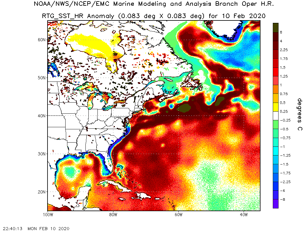
while I know we need the precip, I could go a very long time without another Allison or Ike
http://earth.nullschool.net/#current/oc ... ,34.10,512
link above info: "ocean surface current estimates updated every five days - ocean surface temperatures and anomaly from daily average (1981-2011) updated daily" [click on "earth" at lower left for menu options]
and below, "Anomaly from 1961-1990 climatology, 1 degree, weekly resolution" from http://polar.ncep.noaa.gov/sst/ophi/
while I know we need the precip, I could go a very long time without another Allison or Ike
Update on NHC Products and Services for 2014
www.nhc.noaa.gov/news/20140320_pa_2014seasonChanges.pdf
1) Potential Storm Surge Flooding Map
2) Enhancements to the Tropical Weather Outlook and Graphical Tropical Weather Outlook
3) Elimination of the Intensity Probability Table
4) Use of mixed case in the NHC Tropical Weather Outlook and Tropical Cyclone Discussion. (my favorite)
5) Tropical Cyclone forecast cone will be slightly smaller.
much more in the PDF
A warm Pacific Decadal Oscillation (PDO) generally favors less active hurricane season. However, some of the most active seasons have occurred in warm PDO like 1933, 1995, and 2005. Some occur following an El Nino like 1933, 1995, and 2005. This suggests that 2015 could be an active season. Interestingly, hurricane seasons that end in 5 are active like 1975, 1985, 1995, and 2005.srainhoutx wrote:Interesting thoughts and thanks for sharing unome. I've been watching the pattern that has been in place virtually since last Fall and with the water waters across the N Pacific/Gulf of Alaska and a persistent +PDO which favors a Western trough, the steering currents may suggest a slightly above average chance of landfall tropical systems across the NW Gulf Coast into Louisiana. Another factor is the EPAC and increased SST's and the developing El Nino. Also the SST's across the NW Caribbean Sea as well as the Bay of Campeche are running above normal. I would watch for tropical cyclone genesis across the NW Caribbean and the SW Gulf this season. Although the expected number of tropical cyclones are to be low, those favored areas are a bit close to home and we all know it only takes one land falling storm to make for a very bad season in our neighborhood.
-
srainhoutx
- Site Admin
- Posts: 19616
- Joined: Tue Feb 02, 2010 2:32 pm
- Location: Maggie Valley, NC
- Contact:
I would keep an eye on the tropical wave approaching the Windward Islands. There has been some indication via the Global operational and ensemble guidance that conditions could become a bit more favorable for development once this wave enters the Western Caribbean Sea in about 7-10 days.

Carla/Alicia/Jerry(In The Eye)/Michelle/Charley/Ivan/Dennis/Katrina/Rita/Wilma/Humberto/Ike/Harvey
Member: National Weather Association
Facebook.com/Weather Infinity
Twitter @WeatherInfinity
Member: National Weather Association
Facebook.com/Weather Infinity
Twitter @WeatherInfinity
-
srainhoutx
- Site Admin
- Posts: 19616
- Joined: Tue Feb 02, 2010 2:32 pm
- Location: Maggie Valley, NC
- Contact:
Jeff offers some insight into Hurricane Season 2014:
Today marks the start of the 2014 Atlantic Basin hurricane season which will run through November 30th.
The current NOAA forecast calls for:
8-13 named storms (tropical storms)
3-6 hurricanes
1-2 major hurricanes
The average for the past 30 years has been 12/8/3 so the current forecast is suggestive of a near normal to slightly below normal season activity wise in the Atlantic basin. With that said there is no way to determine where nor when a tropical cyclone may form and what particular part of the US coastline may be impacts if any at this time range. Seasonal forecast prediction of the number of named storms and hurricanes have no skill in predicting landfall locations.
2014 Factors:
Atlantic Sea Surface Temperatures:
For the past several years sea surface temperatures in the (mean development region “MDR”) or that region between Africa and the eastern Caribbean Sea have been slightly to well above normal. Current sea surface data in this region suggest sea surface temperatures are running near to slightly below normal in this region. This suggest slightly less surface ocean energy for tropical cyclone formation in the deep tropics.
Atlantic Atmospheric Instability:
A possible major culprit of the 2013 season “bust” has been the unusually large amounts of stable air across the deep tropical regions of the Atlantic Ocean and especially in that MDR region. It is not understood what may be causing such vast amounts of stability, but it is clearly having an effect on the development and intensification of Atlantic basin tropical cyclones as shown in 2013. Some research suggest that widespread drought conditions in northern South America in 2013 may have produced a stable air layer downstream of the Caribbean Sea and tropical Atlantic, but this is more a hunch than strongly supported by evidence at this moment. Instability indicators in the Atlantic basin continue to run below normal and once again this may point toward a less active hurricane season.
Pacific ENSO Phase:
The biggest factor to consider it the potential formation of warm phase ENSO “El Nino” in the central and eastern tropical Pacific over the next few months. Sea surface and sub-sea surface temperatures are warming in this region suggesting El Nino is potentially developing. The record breaking category 5 Hurricane Amanda in the EPAC in May also suggest a large pool of deep warm water is developing off the South America and central American coast. El Nino tends to produce strong amounts of downstream wind shear over the tropical Atlantic basin and the Caribbean Sea during the peak of the Atlantic hurricane season (August-October). The main questions at this point are how quickly does El Nino develop and how strong does it become. A slower developing El Nino would point to a delayed onset of hostile upper level winds and possibly a slightly more active Atlantic basin while a more rapid onset early in the season (next 1-2 months) would likely hamper peak season development.
While El Nino tends to result in hostile deep tropic conditions research suggest that the Gulf of Mexico and SW Atlantic (off the SE US coast) it not greatly affected by the increased wind shear and in fact these areas tend to be the formation “hot spots” in El Nino years usually with development tied to decaying frontal boundaries. This indicates the potential for close in development and in fact in El Nino summers tend to have roughly a 60% chance of a US landfalling hurricane on the Gulf coast. So while the overall numbers may be lower and the threat for powerful deep tropics hurricanes lessened the threat for Gulf coast landfall is slightly higher in El Nino years.
While the atmospheric factors in place point toward a slightly below average season “it only takes one impact” on our coast to make it bad. 1992 and 1983 were both El Nino seasons with 1992 producing the devastating Hurricane Andrew and 1983 producing Hurricane Alicia (1 of only 4 tropical storms that year). Both of those years did not have the first named storms until the middle or end of August.
Have your plans developed and in place and ready to implement should a tropical cyclone threaten the TX coast this summer.
Carla/Alicia/Jerry(In The Eye)/Michelle/Charley/Ivan/Dennis/Katrina/Rita/Wilma/Humberto/Ike/Harvey
Member: National Weather Association
Facebook.com/Weather Infinity
Twitter @WeatherInfinity
Member: National Weather Association
Facebook.com/Weather Infinity
Twitter @WeatherInfinity


-
srainhoutx
- Site Admin
- Posts: 19616
- Joined: Tue Feb 02, 2010 2:32 pm
- Location: Maggie Valley, NC
- Contact:
Update from Jeff:
An elongated trough of low pressure currently extends from the SE US southwestward across the central Gulf of Mexico into the southern Bay of Campeche and is anchored in the eastern Pacific Ocean by Tropical Storm Boris off the Mexican southern coast.
TS Boris is drifting northward toward the Mexican coast and should progress inland over southern Mexico over the next 24-48 hours.
Global forecast models have been suggesting either energy from TS Boris or a weak surface low pressure system will form on the southern edge of the surface trough over the Bay of Campeche over the next 72-120 hours and drift in place or remain nearly stationary. Current satellite images suggest little to no organization over the Bay of Campeche and strong upper level winds in place which would hamper any near term tropical cyclone formation.
This area is favored this time of year for tropical cyclone formation or potentially “cross over” activity from the eastern Pacific Ocean into the extreme southern Gulf of Mexico. Upper level winds are expected to become slightly more favorable for development by this weekend.
Currently the National Hurricane Center is giving the area a 20% chance of tropical cyclone development over the next 5 days.
Carla/Alicia/Jerry(In The Eye)/Michelle/Charley/Ivan/Dennis/Katrina/Rita/Wilma/Humberto/Ike/Harvey
Member: National Weather Association
Facebook.com/Weather Infinity
Twitter @WeatherInfinity
Member: National Weather Association
Facebook.com/Weather Infinity
Twitter @WeatherInfinity
If something did spin up (weak or a little stronger), I assume most models take this East?
-
srainhoutx
- Site Admin
- Posts: 19616
- Joined: Tue Feb 02, 2010 2:32 pm
- Location: Maggie Valley, NC
- Contact:
Rip, as I mentioned in the June thread a broad monsoonal gyre with several weak surface lows rotating around a broad area of low pressure seems to be the most likely solution. The worrisome aspect is these early June systems often do not behave as the guidance suggest and this broad surface low gyre could last into next week. The Bay of Campeche tends to offer a lot of forecasting difficulties when a monsoon trough is involved ---vs-- and organized compact surface low. Anywhere from Vera Cruz to Florida will probably want to monitor developments day by day.
Carla/Alicia/Jerry(In The Eye)/Michelle/Charley/Ivan/Dennis/Katrina/Rita/Wilma/Humberto/Ike/Harvey
Member: National Weather Association
Facebook.com/Weather Infinity
Twitter @WeatherInfinity
Member: National Weather Association
Facebook.com/Weather Infinity
Twitter @WeatherInfinity
Thank you.
Usually something like this cruises into MX or east.
Usually something like this cruises into MX or east.
-
srainhoutx
- Site Admin
- Posts: 19616
- Joined: Tue Feb 02, 2010 2:32 pm
- Location: Maggie Valley, NC
- Contact:
Or lifts N as a short wave trough crosses Texas.Rip76 wrote:Thank you.
Usually something like this cruises into MX or east.
Carla/Alicia/Jerry(In The Eye)/Michelle/Charley/Ivan/Dennis/Katrina/Rita/Wilma/Humberto/Ike/Harvey
Member: National Weather Association
Facebook.com/Weather Infinity
Twitter @WeatherInfinity
Member: National Weather Association
Facebook.com/Weather Infinity
Twitter @WeatherInfinity
-
wxman57

- Global Moderator
- Posts: 2621
- Joined: Thu Feb 04, 2010 5:34 am
- Location: Southwest Houston (Westbury)
- Contact:
Given the current and predicted strong westerly flow aloft across the northern Gulf, if something should spin up down there and move northward it would likely be quickly turned to the NE rather than northward toward Texas.