

Nothing all week and a paltry showing with the flood-that-wasn't last week. Looks like it's back to sprinkler time for me.
update -- lightning and thunder off to my north and east headed this way.
July 2014: Stalled Front/ Rain Chnaces To End July
-
tireman4

- Global Moderator

- Posts: 4515
- Joined: Wed Feb 03, 2010 9:24 pm
- Location: Humble, Texas
- Contact:
For the upcoming cold/cool front next week. Still early, but some mets are chiming in. Tim Heller, our KTRK OCM, says no cold/cool air for Houston yet again. From his Facebook page:
Your Facebook friends up north are going to get a break from the summer sizzle! Another strong cool front will push south across the U.S. next week. Like the last cool front, this one gets close enough to give us a chance of rain next Tuesday and Wednesday. But the cool air won't reach Houston.
https://www.facebook.com/HellerWeather
would like other mets to chime in on this
-
wxman57

- Global Moderator
- Posts: 2621
- Joined: Thu Feb 04, 2010 5:34 am
- Location: Southwest Houston (Westbury)
- Contact:
Another 1.75" of rain yesterday and 1/2" overnight makes for a total rainfall of 7.42" in July and over 27" for 2014. As for the cold front, it may have about as much impact as last week's. Remember the high of 85 on Saturday with a light NE wind? Clouds and rain may hold our temps down below 90 on a day or two.
-
Heat Miser

- Posts: 229
- Joined: Wed Nov 27, 2013 12:48 pm
- Location: FM 528 @ I45 border of League City, Webster, Friendswood
- Contact:
Last night was a pleasant surprise. Love a storm at night.

Wow, sure is firing up around Alvin again!
-
Paul Robison
Hi, Everybody.
Is there any chance that the remnants of TD#2 could reorganize into a depression (and perhaps a storm) and affect the Houston area? The bloggers at Wunderground.com seem all abuzz about that very prospect.
Is there any chance that the remnants of TD#2 could reorganize into a depression (and perhaps a storm) and affect the Houston area? The bloggers at Wunderground.com seem all abuzz about that very prospect.


Last night was quite stormy for some parts of Houston. Should be quiet tonight.
000
FXUS64 KHGX 242345
AFDHGX
AREA FORECAST DISCUSSION
NATIONAL WEATHER SERVICE HOUSTON/GALVESTON TX
645 PM CDT THU JUL 24 2014
.AVIATION...
SHOULD BE A QUIETER EVENING/OVERNIGHT FOR THE CWA AS DRIER AIR CON-
TINUES TO FILTER IN FROM THE NE. DESPITE THE LINGERING SFC OUTFLOW
BOUNDARIES IN/AROUND THE REGION AND A FEW MORE HRS OF HEATING LEFT
IN THE DAY HAVE OPTED FOR THE MORE OPTIMISTIC VFR FCST (AND NO MEN-
TION OF PCPN THESE NEXT 24-36HRS). 41
&&
.PREV DISCUSSION... /ISSUED 352 PM CDT THU JUL 24 2014/
THESE CELLS HAVE SPIT OUT NORTHWARD-MOVING COLD POOLS THAT HAVE
THEIR LEADING EDGE GUST FRONTS ENTERING THE CITY OF HOUSTON. THE
AIR MASS OVER THE CITY IS CURRENTLY IN THE LOW 90S OVER LOWER 70S
AND 12Z RAOB PROG SOUNDINGS (NAM) SUGGEST THAT THIS OUTFLOW WILL
BE ENTERING AN UNSTABLE OF ENOUGH AIR MASS TO PRODUCE FURTHER SLOW
MOVERS WITH AN ADDITIONAL THREAT FOR DOWNBURST WIND (WEAK 85H WIND
AND INVERTED V PROFILES). NO SIGNIFICANT SHORTWAVE DISTURBANCE
NOTED IN THE NORTHEASTERLY STEERING FLOW INDICATES THAT ONCE
HEATING IS LOST AT SUNSET...THIS MESOSCALE BEHAVIOR WILL WANE INTO
THE EARLY EVENING HOURS AND GO QUIET LATE IN THE EVENING.
AS WAS THE CASE WITH PRIOR SPECTRAL SCALE MODELING SOLUTIONS...THE
UPPER RIDGE CENTERED OVER THE DESERT SOUTHWEST WILL EXPAND EASTWARD
AND ENCOMPASS EASTERN TEXAS GOING INTO THE WEEKEND. ALTHOUGH THIS
MORNING`S CONVECTION WAS TRIGGERED BY NORTHERN OUTFLOW BOUNDARIES
.THIS AFTERNOON`S ACTIVITY APPEARED TO BE MORE MESOSCALE IN NATURE
AND FOCUS UPON DISCERNIBLE LOWER LAYER BOUNDARIES. FRIDAY`S POPS
WILL DEPENDENT UPON ONE MAJOR FACTOR...THE STRENGTH OF RIDGING. AS
MOISTURE/STABILITY INDICES REMAIN NEARLY UNVARIED... IF EASTERN
TEXAS STILL LAYS ON THE EASTERN PERIPHERY OF WESTERN RIDGING BY
THIS TIME TOMORROW...THERE WILL LIKELY BE A REPEAT IN THIS SCATTERED
LATE MORNING THROUGH EARLY EVENING BLOSSOM-TYPE CONVECTION. THE
FOCUS WILL EITHER BE ON AN EVOLVING SEA BREEZE BOUNDARY OR UPON
RESIDUAL BOUNDARIES LEFT OVER FROM TODAY`S ACTION. FORECAST LEANS
TO STRONGER RIDGING AND THUS LESS INITIALIZATION OVER A SMALLER
AREA...AROUND SLIGHT CHANCES WILL BE THE CALL. THE WEEKEND IS WHEN
ALL-LEVEL RIDGING TAKES BETTER ANCHOR OVER THE WESTERN GULF COAST
..SHUTTING OFF THE SHRA/TSRA VALVE THROUGH TUESDAY OF NEXT WEEK.
A FEW DAYS OF SUPPRESSION WILL MAKE FOR SUNNIER SKIES AND EVER-
WARMER MORNINGS THAT WILL SUBSEQUENTLY LEAD TO INTERIOR MAXIMUM
TEMPERATURES COMING VERY CLOSE TO THE CENTURY MARK EARLY NEXT
WEEK. 1000-5H THICKNESSES INCREASING INTO THE LOWER 580S...WITH
85H TEMPERATURES WARMING INTO THE LOWER 20S...MONDAY AND TUESDAY
ARE GOOD SIGNS THAT...IF THIS RECENTLY-MOIST GROUND DRIES OUT (AND
IT SHOULD OVER THE WEEKEND)...THAT LATE JULY TRIPLE DIGIT HEAT AND
EXCESSIVE HEAT WILL BEGIN TO CREEP INTO NEXT WEEK`S DAY-TO-DAY
CONVERSATION(S). 31
MARINE...
STILL EXPECTING SOUTH TO SOUTHWEST WINDS THROUGH THE END OF THE
WEEK AND INTO THE WEEKEND. WINDS MAY INCREASE TO MODERATE LEVELS
OVER THE WEEKEND BUT THEN DECREASE EARLY NEXT WEEK AS A FRONTAL
BOUNDARY APPROACHES EAST TX AND THE GRADIENT RELAXES. LIGHT TO
MODERATE WINDS WILL SUPPORT MAINLY LOW SEAS FOR THE NEXT SEVERAL
DAYS. NO MARINE HAZARDS ARE EXPECTED AT THIS TIME. 42
&&
.PRELIMINARY POINT TEMPS/POPS...
COLLEGE STATION (CLL) 75 98 76 98 77 / 10 10 10 10 10
HOUSTON (IAH) 75 97 76 96 77 / 20 30 10 10 10
GALVESTON (GLS) 80 92 80 90 81 / 20 20 20 10 10
&&
.HGX WATCHES/WARNINGS/ADVISORIES...
TX...NONE.
GM...NONE.
&&
$$
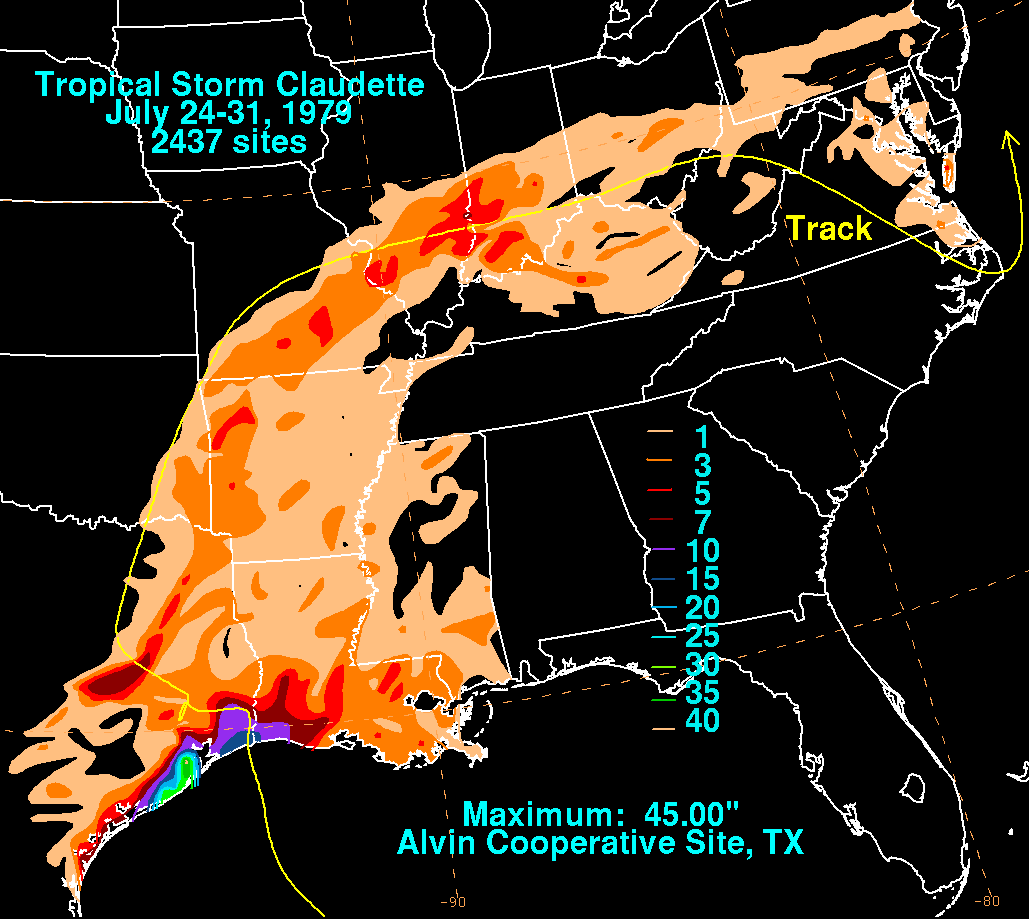
On this day, Tropical Storm Claudette dumped heavy rains south of Houston. An area near Alvin saw 43 inches of rain in 24 hours!
-
Paul Robison
Ptarmigan wrote:On this day, Tropical Storm Claudette dumped heavy rains south of Houston. An area near Alvin saw 43 inches of rain in 24 hours!
Where were you during 1979's Claudette,? Ptarmigan? I was a middle school student on summer vacation when that happened.

-
jojotheidiotclown
- Posts: 46
- Joined: Wed Apr 25, 2012 4:01 pm
- Contact:
If that above comes true, I am moving to florida. This summer has been insanely cool. Breaking 95 on a few occasions. Fall is right around the corner and another round of cold crap is the last thing needed. We have not had a chance to really enjoy the summer.

If the above does verify, that would be freaking awesome.
And my light bill will be happier too.
And my light bill will be happier too.

-
tireman4
- Global Moderator
- Posts: 4515
- Joined: Wed Feb 03, 2010 9:24 pm
- Location: Humble, Texas
- Contact:
Tim Heller is still saying no, as of now.
Hottest temps this summer (so far!) coming up this weekend and early next week. Heat Index will hit 100-106° every afternoon. A cool front brings rain late next week....but no cool air.
https://www.facebook.com/HellerWeather
Hottest temps this summer (so far!) coming up this weekend and early next week. Heat Index will hit 100-106° every afternoon. A cool front brings rain late next week....but no cool air.
https://www.facebook.com/HellerWeather
-
tireman4
- Global Moderator
- Posts: 4515
- Joined: Wed Feb 03, 2010 9:24 pm
- Location: Humble, Texas
- Contact:
But could the HGX NWS be biting on something...hummm...
Monday Mostly sunny, with a high near 95.
Monday Night Partly cloudy, with a low around 76.
Tuesday A 30 percent chance of showers and thunderstorms. Partly sunny, with a high near 95.
Tuesday Night A 30 percent chance of showers and thunderstorms. Mostly cloudy, with a low around 75.
Wednesday A 30 percent chance of showers and thunderstorms. Mostly cloudy, with a high near 91.
Wednesday Night A 20 percent chance of showers and thunderstorms. Mostly cloudy, with a low around 74.
Thursday A 30 percent chance of showers and thunderstorms. Mostly cloudy, with a high near 90.
http://forecast.weather.gov/MapClick.ph ... 9Jwb6MoMYu
tireman4 wrote:Tim Heller is still saying no, as of now.
Hottest temps this summer (so far!) coming up this weekend and early next week. Heat Index will hit 100-106° every afternoon. A cool front brings rain late next week....but no cool air.
https://www.facebook.com/HellerWeather
I think that's because the CPC forecast you posted is not for this wkend & early next week, it's for Jul 30th - Aug 3rd, almost 5 days away & it will be hot until then
if you look at WPC's day 3-7 max temps, it starts getting cooler on the 30th & next Fri looks heavenly... let's hope it happens & doesn't miss us ! http://www.wpc.ncep.noaa.gov/medr/maxloop.html
-
tireman4
- Global Moderator
- Posts: 4515
- Joined: Wed Feb 03, 2010 9:24 pm
- Location: Humble, Texas
- Contact:
HGX AFD this morning:
PREV DISCUSSION... /ISSUED 428 AM CDT SAT JUL 26 2014/
DISCUSSION...
NOT QUITE AS MUCH CONVECTION THIS MORNING AS YESTERDAY WITH ONLY
ONE SHOWER FORMING ON THE LAND BREEZE IN THE UPPER TX COASTAL
WATERS. HIGHER MOISTURE REMAINS JUST ALONG THE COAST WITH 00Z
LCH/CRP SOUNDINGS SHOWING ABOUT 2 INCHES OF PRECIP WATER.
CONDITIONS BECOME DRIER FARTHER INLAND. UPPER LEVEL 500MB ANALYSIS
SHOWS UPPER LEVEL RIDGE OVER S ROCKIES STRETCHING INTO THE N TX.
THINK SUBSIDENCE SHOULD BE STRONGER TODAY INTO SUNDAY. THERE MAY
BE A STRAY OR ISO SHOWER OR THUNDERSTORM TODAY ALONG THE SEA
BREEZE IN THE AFTERNOON BUT WILL ONLY GO WITH A 10 PERCENT CHANCE.
CONFIDENCE JUST NOT HIGH ENOUGH TO WARRANT PUTTING IN THE
FORECAST AND DO NOT EXPECT MUCH COVERAGE IN ACTIVITY IF ANY.
SYNOPTIC MODELS BUILD UPPER LEVEL RIDGE OVER N TX TODAY INTO
SUNDAY. RIDGE SHOULD SUPPORT HIGH TEMPERATURES MORE IN THE
MID/UPPER 90S BUT DO NOT THINK THE CENTURY MARK WILL BE IN REACH.
HEAT INDEX VALUES HOWEVER SHOULD APPROACH 105 INSTEAD OF 101/102
LIKE THE LAST COUPLE OF DAYS.
UPPER LOW OVER THE CANADIAN PRAIRIES WILL DROP SE TOWARDS LAKE
MICH ON SUNDAY WHICH WILL HELP BUILD THE RIDGE OVER THE ROCKIES.
BY MONDAY BROAD TROUGH DEVELOPS OVER THE GREAT LAKES WITH RIDGE
FROM W TX INTO THE N ROCKIES. LOOK FOR NW FLOW ALOFT TO DEVELOP
OVER THE PLAINS FOR THE MIDDLE OF THE WEEK. THIS WILL ALSO ALLOW
FOR THE RIDGE TO STAY WEST OF THE REGION AND ALLOW FOR A SHORTWAVE
TROUGH OR TWO TO WORK INTO THE AREA. LOOKS LIKE STRONGEST
SHORTWAVE MOVES INTO THE AREA LATE WED INTO THUR.
UPPER LEVEL PATTERN ALSO OPENS THE DOOR FOR A COLD FRONT TO PUSH
INTO THE AREA MON NIGHT INTO TUE. GFS/NAM/ECMWF AREA ALL PUSHING
THE FRONT INTO THE AREA FASTER THAN BEFORE AND STALLING IT ON TUE.
THIS WILL SUPPORT SCT THUNDERSTORM ACTIVITY ALONG WITH THE
POTENTIAL FOR BRIEF HEAVY RAINFALL. PRECIP WATER VALUES OF OVER 2
INCHES REMAIN INVOF THE FRONT THROUGH THE MIDDLE OF THE WEEK.
FORECAST WILL KEEP 20/30 POPS IN PLACE BEGINNING TUE. THERE IS
SOME DRIER AIR THAT MOVES INTO SE TX BEHIND THE FRONT SO SOME OF
THE NORTHERN COUNTIES MAY SEE A DROP IN DEWPOINTS AND MOISTURE.
THE MAIN FORECAST PROBLEM WILL BE DETERMINING EXACTLY WHERE THE
FRONT STALLS AND HOW MUCH MOISTURE WILL INTERACT WITH IT UNDER NW
FLOW ALOFT. BOTH THE ECMWF/GFS BRING A SHORTWAVE TROUGH THROUGH
THE PLAINS INTO THE ARKLATEX LATE WED INTO THUR. WILL KEEP SOME 30
POPS IN THE FORECAST FOR THUR AND THEN 20 POPS FOR THE REST OF THE
WEEK. IT LOOKS LIKE THE TROUGH MAY FURTHER BROADEN OVER THE MISS
RIVER VALLEY WITH AN UPPER RIDGE OVER THE 4 CORNERS REGION.
39
MARINE...
LIGHT TO MODERATE SOUTH TO SOUTHWEST WINDS WILL PERSIST THROUGH THE
WEEKEND AND INTO THE FIRST HALF OF NEXT WEEK. WINDS WILL EASE
SLIGHTLY BY MID WEEK AS A COLD FRONT MOVES INTO SOUTHEAST TEXAS.
http://forecast.weather.gov/product.php ... glossary=1
Pouring here in League City
-
- Information
-
Who is online
Users browsing this forum: Ahrefs [Bot], Amazon [Bot], Bing [Bot], Pas_Bon and 6 guests