
BULLETIN
TROPICAL STORM CARLOS INTERMEDIATE ADVISORY NUMBER 7A
NWS NATIONAL HURRICANE CENTER MIAMI FL EP032015
700 AM CDT FRI JUN 12 2015
...CARLOS STATIONARY SOUTH OF MEXICO...
SUMMARY OF 700 AM CDT...1200 UTC...INFORMATION
----------------------------------------------
LOCATION...14.7N 100.8W
ABOUT 165 MI...265 KM SSW OF ACAPULCO MEXICO
ABOUT 215 MI...345 KM SSE OF ZIHUATANEJO MEXICO
MAXIMUM SUSTAINED WINDS...60 MPH...95 KM/H
PRESENT MOVEMENT...STATIONARY
MINIMUM CENTRAL PRESSURE...997 MB...29.44 INCHES
WATCHES AND WARNINGS
--------------------
CHANGES WITH THIS ADVISORY:
None.
SUMMARY OF WATCHES AND WARNINGS IN EFFECT:
A Tropical Storm Watch is in effect for...
* Acapulco to Zihuatanejo
A Tropical Storm Watch means that tropical storm conditions are
possible within the watch area, generally within 48 hours.
For storm information specific to your area, please monitor
products issued by your national meteorological service.
DISCUSSION AND 48-HOUR OUTLOOK
------------------------------
At 700 AM CDT (1200 UTC), the center of Tropical Storm Carlos was
located near latitude 14.7 North, longitude 100.8 West. Carlos is
currently stationary, and only a slow movement to the northwest is
expected over the next couple of days.
Maximum sustained winds remain near 60 mph (95 km/h) with higher
gusts. Some strengthening is expected, and Carlos is forecast to
become a hurricane on Saturday.
Tropical storm force winds extend outward up to 80 miles (130 km)
from the center.
The estimated minimum central pressure is 997 mb (29.44 inches).
HAZARDS AFFECTING LAND
----------------------
WIND: Tropical storm conditions are possible within the watch area
by Saturday night.
RAINFALL: Locally heavy rains could spread over portions of the
southern coast of Mexico, primarily in the states of Oaxaca and
Guerrero, during the next couple of days.
SURF: Swells associated with Carlos are expected to increase near
the coast of southern Mexico during the next few days. These swells
could cause life-threatening surf and rip current conditions.
Please consult products from your local weather office.
NEXT ADVISORY
-------------
Next complete advisory at 1000 AM CDT.
2015 Eastern Pacific Tropical Weather Discussion
-
srainhoutx

- Site Admin

- Posts: 19616
- Joined: Tue Feb 02, 2010 2:32 pm
- Location: Maggie Valley, NC
- Contact:
- Attachments
-
Carla/Alicia/Jerry(In The Eye)/Michelle/Charley/Ivan/Dennis/Katrina/Rita/Wilma/Humberto/Ike/Harvey
Member: National Weather Association
Facebook.com/Weather Infinity
Twitter @WeatherInfinity
Member: National Weather Association
Facebook.com/Weather Infinity
Twitter @WeatherInfinity
it snuck up while distracted with 91L http://www.nhc.noaa.gov/#CARLOS
ZCZC MIATCDEP3 ALL
TTAA00 KNHC DDHHMM
HURRICANE CARLOS DISCUSSION NUMBER 12
NWS NATIONAL HURRICANE CENTER MIAMI FL EP032015
1000 AM CDT SAT JUN 13 2015
Satellite data indicate that Carlos has strengthened with a ragged
eye becoming apparent on the latest visible imagery. In addition,
radar data from Acapulco show that an eyewall has become
established, although it is still open on the north side. Dvorak
estimates from TAFB/SAB are 65 kt, so this will be the initial
intensity.
After an eastward jog overnight, Carlos appears to have resumed a
northwestward drift. For the rest of the weekend, a building ridge
over Mexico is expected to steer Carlos generally to the
west-northwest. Thereafter, a mid-level trough near the Baja
California peninsula should cause Carlos to turn northwestward.
However, the hurricane is now farther to the east than expected
yesterday, which has moved the track closer to the southwestern
coast of Mexico. Track guidance has been steadily shifting
eastward, and a few models are now showing landfall in Mexico. While
I am not yet ready to show that solution, the NHC prediction has
been shifted eastward to account for the greater threat to Mexico.
Accordingly, the government of Mexico has issued a tropical storm
warning and hurricane watch for a portion of the southwestern coast.
Since Carlos is expected to remain over very warm water with
decreasing shear, it seems likely that further intensification will
occur over the next day or so. However, there is very poor
agreement on what will occur after that time due to competing
atmospheric factors and possible land interaction. The new NHC
forecast stays on the upper end of the guidance and is raised from
the previous one. It is worth noting that the normally
conservative HWRF is above the latest NHC prediction.
With Carlos becoming a hurricane, this is the second earliest on
record that the third hurricane has occurred in the eastern
Pacific season, one day behind the third hurricane of 1956.
FORECAST POSITIONS AND MAX WINDS
INIT 13/1500Z 14.9N 100.2W 65 KT 75 MPH
12H 14/0000Z 15.2N 100.5W 70 KT 80 MPH
24H 14/1200Z 15.8N 101.3W 75 KT 85 MPH
36H 15/0000Z 16.3N 102.2W 75 KT 85 MPH
48H 15/1200Z 16.9N 103.1W 70 KT 80 MPH
72H 16/1200Z 18.6N 105.0W 65 KT 75 MPH
96H 17/1200Z 20.5N 106.2W 50 KT 60 MPH
120H 18/1200Z 22.5N 107.5W 40 KT 45 MPH
$$
Forecaster Blake
NNNN
http://www.nhc.noaa.gov/#CARLOS
...CARLOS WEAKENS TO A TROPICAL STORM JUST SOUTH OF MEXICO... ...EXPECTED TO RESTRENGTHEN INTO A HURRICANE BY MONDAY...
10:00 AM CDT Sun Jun 14
Location: 15.9°N 100.4°W
Moving: NW at 2 mph
Min pressure: 986 mb
Max sustained: 70 mph
000
WTPZ33 KNHC 141449
TCPEP3
BULLETIN
TROPICAL STORM CARLOS ADVISORY NUMBER 16
NWS NATIONAL HURRICANE CENTER MIAMI FL EP032015
1000 AM CDT SUN JUN 14 2015
...CARLOS WEAKENS TO A TROPICAL STORM JUST SOUTH OF MEXICO...
...EXPECTED TO RESTRENGTHEN INTO A HURRICANE BY MONDAY...
SUMMARY OF 1000 AM CDT...1500 UTC...INFORMATION
-----------------------------------------------
LOCATION...15.9N 100.4W
ABOUT 75 MI...125 KM SSW OF ACAPULCO MEXICO
ABOUT 190 MI...300 KM SE OF LAZARO CARDENAS MEXICO
MAXIMUM SUSTAINED WINDS...70 MPH...110 KM/H
PRESENT MOVEMENT...NW OR 320 DEGREES AT 2 MPH...4 KM/H
MINIMUM CENTRAL PRESSURE...986 MB...29.12 INCHES
WATCHES AND WARNINGS
--------------------
CHANGES WITH THIS ADVISORY:
The Government of Mexico has discontinued the Tropical Storm Warning
east of Acapulco.
SUMMARY OF WATCHES AND WARNINGS IN EFFECT:
A Hurricane Warning is in effect for...
* Punta San Telmo to Tecpan de Galeana
A Hurricane Watch is in effect for...
* West of Punta San Telmo to Manzanillo
A Tropical Storm Warning is in effect for...
* East of Tecpan de Galeana to Acapulco
A Hurricane Warning means that hurricane conditions are expected
somewhere within the warning area. A warning is typically issued
36 hours before the anticipated first occurrence of
tropical-storm-force winds, conditions that make outside
preparations difficult or dangerous. Preparations to protect life
and property should be rushed to completion.
A Hurricane Watch means that hurricane conditions are possible
somewhere within the watch area within 48 hours.
A Tropical Storm Warning means that tropical storm conditions are
expected somewhere within the warning area, in this case within
the next 12 to 24 hours.
Interests elsewhere along the southwest coast of Mexico should
monitor the progress of Carlos.
For storm information specific to your area, please monitor
products issued by your national meteorological service.
DISCUSSION AND 48-HOUR OUTLOOK
------------------------------
At 1000 AM CDT (1500 UTC), the center of Tropical Storm Carlos was
located near latitude 15.9 North, longitude 100.4 West. Carlos is
moving toward the northwest near 2 mph (4 km/h) and this general
motion is expected to continue through Monday. A turn toward the
west-northwest with some increase in forward speed is expected over
the next couple of days.
Maximum sustained winds have decreased to near 70 mph (110 km/h)
with higher gusts. However, some restrengthening is forecast during
the next 48 hours, and Carlos is expected to become a hurricane
again by Monday.
Tropical-storm-force winds extend outward up to 70 miles (110 km)
from the center.
The estimated minimum central pressure is 986 mb (29.12 inches).
HAZARDS AFFECTING LAND
----------------------
WIND: Tropical storm conditions are expected within the tropical
storm warning area today, and Acapulco recently reported a gust to
43 mph (69 km/h). Hurricane conditions are expected to begin within
the hurricane warning area on Monday. Hurricane conditions are
possible within the hurricane watch area Monday night or early
Tuesday.
RAINFALL: Carlos is expected to produce rains in the Mexican states
of Oaxaca, Guerrero, Michoacan, Colima and Jalisco, with rainfall
accumulations of 6 to 10 inches possible through Tuesday with
maximum totals of 15 inches possible. These rains may produce
life-threatening flash floods and mud slides, especially in areas of
higher terrain.
SURF: Swells associated with Carlos will affect the coasts of
southern and southwestern Mexico during the next few days. These
swells could cause life-threatening surf and rip currents. Please
consult products from your local weather office.
NEXT ADVISORY
-------------
Next intermediate advisory at 100 PM CDT.
Next complete advisory at 400 PM CDT.
$$
Forecaster Stewart
http://www.nhc.noaa.gov/#CARLOS
000
WTPZ33 KNHC 150836
TCPEP3
BULLETIN
TROPICAL STORM CARLOS ADVISORY NUMBER 19
NWS NATIONAL HURRICANE CENTER MIAMI FL EP032015
400 AM CDT MON JUN 15 2015
...CARLOS STILL A TROPICAL STORM...
SUMMARY OF 400 AM CDT...0900 UTC...INFORMATION
----------------------------------------------
LOCATION...16.7N 101.8W
ABOUT 125 MI...205 KM W OF ACAPULCO MEXICO
ABOUT 95 MI...150 KM SSE OF LAZARO CARDENAS MEXICO
MAXIMUM SUSTAINED WINDS...70 MPH...110 KM/H
PRESENT MOVEMENT...WNW OR 295 DEGREES AT 6 MPH...9 KM/H
MINIMUM CENTRAL PRESSURE...988 MB...29.18 INCHES
WATCHES AND WARNINGS
--------------------
CHANGES WITH THIS ADVISORY:
None.
SUMMARY OF WATCHES AND WARNINGS IN EFFECT:
A Hurricane Warning is in effect for...
* Punta San Telmo to Tecpan de Galeana
A Hurricane Watch is in effect for...
* West of Punta San Telmo to Playa Perula
Interests elsewhere along the southwest coast of Mexico should
monitor the progress of Carlos.
For storm information specific to your area, please monitor
products issued by your national meteorological service.
DISCUSSION AND 48-HOUR OUTLOOK
------------------------------
At 400 AM CDT (0900 UTC), the center of Tropical Storm Carlos was
located near latitude 16.7 North, longitude 101.8 West. Carlos is
moving toward the west-northwest near 6 mph (9 km/h). This
general motion is expected to continue through Tuesday, followed
by a turn toward the northwest on Wednesday. On the forecast track,
Carlos will move parallel to the southern coast of Mexico over the
next day or two. However, a small deviation to the north of the
track would bring the center of Carlos closer to the coast.
Maximum sustained winds remain near 70 mph (110 km/h) with higher
gusts. Some strengthening is expected during the next 24 hours and
Carlos is forecast to become a hurricane again by early Tuesday.
Carlos is small cyclone. Tropical-storm-force winds extend outward
up to 45 miles (75 km) from the center.
The estimated minimum central pressure is 988 mb (29.18 inches).
HAZARDS AFFECTING LAND
----------------------
WIND: Hurricane conditions are expected to begin within the
hurricane warning area today. Hurricane conditions are possible
within the hurricane watch area tonight or early Tuesday.
RAINFALL: Carlos is expected to produce rains in the Mexican states
of Guerrero, Michoacan, Colima, Jalisco and Nayarit, with rainfall
accumulations of 6 to 10 inches possible through Wednesday, and
maximum totals of 15 inches possible. These rains may produce life-
threatening flash floods and mud slides, especially in areas of
higher terrain.
SURF: Swells associated with Carlos will affect the coasts of
southern and southwestern Mexico during the next few days. These
swells could cause life-threatening surf and rip currents. Please
consult products from your local weather office.
NEXT ADVISORY
-------------
Next intermediate advisory at 700 AM CDT.
Next complete advisory at 1000 AM CDT.
$$
Forecaster Roberts
-
srainhoutx
- Site Admin
- Posts: 19616
- Joined: Tue Feb 02, 2010 2:32 pm
- Location: Maggie Valley, NC
- Contact:
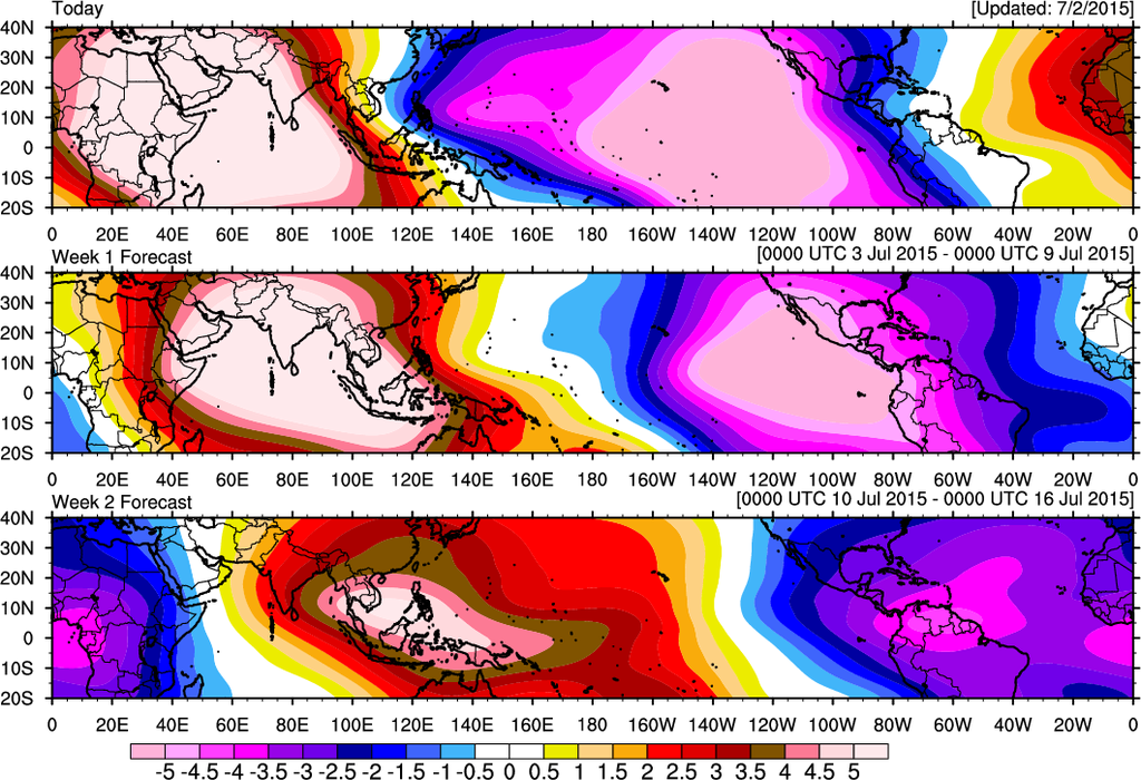
A very strong WWB (Westerly Wind Burst) associated with a very strong MJO pulse continues to migrate E toward the Eastern Pacific Ocean. To the West across the Western Pacific no less than 4 tropical cyclones are developing (3 North of the equator and 1 South of the equator) due to the strong MJO among other factors and the Global guidance is beginning to indicate at least 3 possible tropical cyclones may develop SE and E of Hawaii and offshore of Mexico as the MJO pulse migrates closer to the Western Atlantic Basin. Hopefully all this tropical troubles clears up over the next 45 days as I am due to depart for Hawaii around mid August for a week of much needed R and R on Waikiki Beach. Off course Rick Knabb and Bill Read were kidding me at the Houston/Galveston Hurricane Workshop that I may have a front row seat since the Central Pacific is expected to see above average activity this season... 
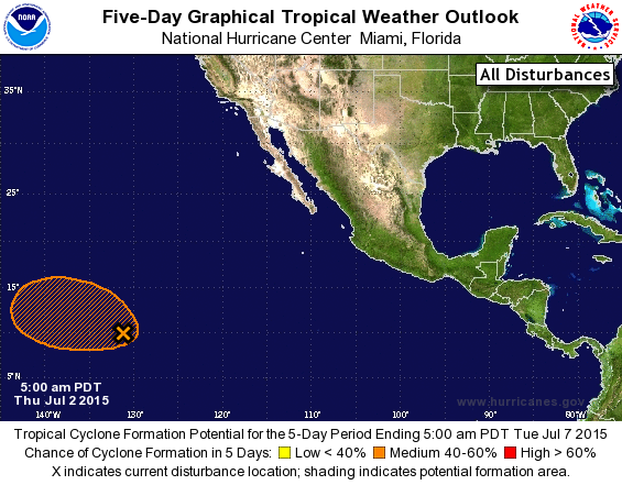
TROPICAL WEATHER OUTLOOK
NWS NATIONAL HURRICANE CENTER MIAMI FL
500 AM PDT THU JUL 2 2015
For the eastern North Pacific...east of 140 degrees west longitude:
1. An area of disturbed weather has formed about 1700 miles
east-southeast of the Hawaiian Islands. Environmental conditions
are forecast to become conducive for gradual development of this
system over the next several days while it moves slowly
west-northwestward.
* Formation chance through 48 hours...low...near 20 percent
* Formation chance through 5 days...medium...50 percent
Forecaster Brown
Carla/Alicia/Jerry(In The Eye)/Michelle/Charley/Ivan/Dennis/Katrina/Rita/Wilma/Humberto/Ike/Harvey
Member: National Weather Association
Facebook.com/Weather Infinity
Twitter @WeatherInfinity
Member: National Weather Association
Facebook.com/Weather Infinity
Twitter @WeatherInfinity
-
srainhoutx
- Site Admin
- Posts: 19616
- Joined: Tue Feb 02, 2010 2:32 pm
- Location: Maggie Valley, NC
- Contact:
EPAC INVEST 91L continues to organize this afternoon and could pose a threat to Hawaii in about a week. If the westward motion continues and the threat to Hawaii increases, the 53rd Weather Reconnaissance Squadron (Hurricane Hunters) make begin transitioning a C-130 from Biloxi to Hickam Field in Pearl Harbor to investigate this weekend.

Carla/Alicia/Jerry(In The Eye)/Michelle/Charley/Ivan/Dennis/Katrina/Rita/Wilma/Humberto/Ike/Harvey
Member: National Weather Association
Facebook.com/Weather Infinity
Twitter @WeatherInfinity
Member: National Weather Association
Facebook.com/Weather Infinity
Twitter @WeatherInfinity
-
srainhoutx
- Site Admin
- Posts: 19616
- Joined: Tue Feb 02, 2010 2:32 pm
- Location: Maggie Valley, NC
- Contact:
I've been watching this little disturbance for about the past week which had some model support of becoming the next possible threat to Hawaii as it churns W across the Eastern Pacific. 93E lost all model support for developing into a tropical cyclone but continues fight the odds of a lot of dry air and wind shear as convection is still developing within a modest Convectively Coupled Kelvin Wave and raising air associated with a bit of a wet phase MJO pulse. I'll be watching this disturbance a bit more closely to see if it has a trick or two up its sleeve and interferes with my trip to Hawaii next week.
- Attachments
-
Carla/Alicia/Jerry(In The Eye)/Michelle/Charley/Ivan/Dennis/Katrina/Rita/Wilma/Humberto/Ike/Harvey
Member: National Weather Association
Facebook.com/Weather Infinity
Twitter @WeatherInfinity
Member: National Weather Association
Facebook.com/Weather Infinity
Twitter @WeatherInfinity
-
srainhoutx
- Site Admin
- Posts: 19616
- Joined: Tue Feb 02, 2010 2:32 pm
- Location: Maggie Valley, NC
- Contact:
TROPICAL WEATHER OUTLOOK
NWS NATIONAL HURRICANE CENTER MIAMI FL
1100 AM PDT TUE AUG 11 2015
For the eastern North Pacific...east of 140 degrees west longitude:
1. Shower and thunderstorm activity has become better organized this
morning in association with an area of low pressure located about
1400 miles west-southwest of the southern tip of the Baja California
peninsula. While environmental conditions are expected to become
increasingly unfavorable for development, this system could become a
tropical depression later today or tonight while it moves westward
at around 10 mph.
* Formation chance through 48 hours...medium...50 percent
* Formation chance through 5 days...medium...50 percent
2. A tropical wave located south of the coast of Guatemala and El
Salvador is producing an area of disorganized cloudiness and
showers. An area of low pressure is forecast to form in association
with this wave a few hundred miles south-southwest of the coast of
Mexico later this week. Environmental conditions should support
gradual development of the low by the weekend while it moves
west-northwestward at about 15 mph.
* Formation chance through 48 hours...low...10 percent
* Formation chance through 5 days...high...70 percent
Forecaster Brennan
Carla/Alicia/Jerry(In The Eye)/Michelle/Charley/Ivan/Dennis/Katrina/Rita/Wilma/Humberto/Ike/Harvey
Member: National Weather Association
Facebook.com/Weather Infinity
Twitter @WeatherInfinity
Member: National Weather Association
Facebook.com/Weather Infinity
Twitter @WeatherInfinity