


Anything above 95th percentile is an outlier. I am sure they will re-evaluate the curve.jasons wrote:It seems over the last few years, and this year especially, every storm system that moved across pushed moisture into the "99th percentile". By definition that's supposed to be a rare event. But it's not. At what point does the "99th" percentile become the new normal? When does the curve get re-evaluated and shift?
May 2015 Record Setting May Rainfall Totals For Region
-
srainhoutx

- Site Admin

- Posts: 19616
- Joined: Tue Feb 02, 2010 2:32 pm
- Location: Maggie Valley, NC
- Contact:
Our string of pleasant weather days will begin to transition to a somewhat unsettled weather pattern next week. The overnight ensemble guidance continues to advertise the upper ridge that has been responsible for the quiet weather pattern this week will flatten out and be replaced with a developing Western trough and increasing onshore flow off the Western Gulf of Mexico.
The first in a series of shortwaves is moving east from the Eastern Pacific and will be near Northern Mexico as the weekend ends. Leeside cyclogenesis across the Central/Southern Rockies in response to the pressure falls out west will increase the onshore flow Monday and continue ushering in increasing moisture as the week progresses. A second upper air disturbance is expected to begin dropping SE into the Great Basin from the Gulf of Alaska early next week and meander as a split zonal flow develops. That upper low appears to become trapped across the Great Basin as a stout upper ridge develops across the Mississippi Valley and the Southern flow becomes stagnant or slow moving. The Northern jet continues to remain well up into Canada setting the stage for strong and possibly some severe thunderstorms to develop east of the Continental Divide into the Great Plains. This stagnant flow across the West and Central United States appears to linger into at least next weekend.
There are still indications via the various computer model schemes that a subtropical/extra tropical low pressure system may develop next week near the Bahamas and meander offshore of the Southeastern US Coastline as upper ridging builds north of that feature. The greatest concern for heavier rainfall looks to be focused from Texas across the Southern/Central Plains into Minnesota and across Southern Florida.
Carla/Alicia/Jerry(In The Eye)/Michelle/Charley/Ivan/Dennis/Katrina/Rita/Wilma/Humberto/Ike/Harvey
Member: National Weather Association
Facebook.com/Weather Infinity
Twitter @WeatherInfinity
Member: National Weather Association
Facebook.com/Weather Infinity
Twitter @WeatherInfinity
Some of the analog dates are interesting like 1957 and 1989.
-
Paul Robison
Will this help?
And then there's this little tidbit from SPC:
PRIOR TO THE EMERGENCE OF THE LEAD IMPULSE FROM THE SOUTHWEST...
MODELS CONTINUE TO SUGGEST THAT THERE WILL BE SUBSTANTIVE LOWER/MID
TROPOSPHERIC COOLING AND STABILIZATION OF MID-LEVEL LAPSE RATES
ACROSS THE PLAINS...WITH THE POSSIBLE EXCEPTION OF AREAS NEAR THE
LOWER RIO GRANDE VALLEY. WITH RICH...TROPICAL BOUNDARY LAYER
MOISTURE PROBABLY REMAINING CONFINED TO MEXICAN GULF COASTAL
AREAS...THE CARIBBEAN AND SOUTHWESTERN ATLANTIC INTO AT LEAST EARLY
PORTIONS OF THE PERIOD /DUE TO THE CONTINUING PRESENCE OF UPPER
TROUGHING ACROSS THAT REGION...SEVERE WEATHER POTENTIAL STILL SEEMS
LIKELY TO REMAIN SEASONABLY LOW. MORE SUBSTANTIVE DESTABILIZATION
DOES APPEAR POSSIBLE IN THE WAKE OF THIS LEAD IMPULSE...ACROSS PARTS
OF THE PLAINS AND MISSISSIPPI VALLEY...LATE THIS COMING WEEK INTO
NEXT WEEKEND. HOWEVER...DUE TO THE LOW PATTERN
PREDICTABILITY...SEVERE PROBABILITIES CURRENTLY REMAIN BELOW 15
PERCENT THROUGH THE PERIOD.Sorry I couldn't include the whole thing, but SE TX will not get very much rain out of this, if it verifies. Any severe likely in the area Tues-Wednesday, BTW?
-
srainhoutx
- Site Admin
- Posts: 19616
- Joined: Tue Feb 02, 2010 2:32 pm
- Location: Maggie Valley, NC
- Contact:
The overnight guidance continues to struggle with the evolving pattern and how the leading shortwave ejecting out of Northern Mexico will affect the sensible weather across Texas, Eastern New Mexico and Oklahoma. The Storm Prediction Center has outlined a Slight Risk for severe storms across portions of West Central Texas and Eastern New Mexico as the shortwave meanders ENE and convective activity along the dryline could increase. The various computer model scheme are not in very good agreement as to the strength of this shortwave, so expect day to day changes. Meanwhile, the upper ridge that has brought our pleasant weather of late continues to slide E and we should begin to see moisture returning off the Gulf of Mexico increasing daily as a persistent Western trough develops and lingers as several upper low features drop SE into the Great Basin at least through next weekend...if not longer.

Carla/Alicia/Jerry(In The Eye)/Michelle/Charley/Ivan/Dennis/Katrina/Rita/Wilma/Humberto/Ike/Harvey
Member: National Weather Association
Facebook.com/Weather Infinity
Twitter @WeatherInfinity
Member: National Weather Association
Facebook.com/Weather Infinity
Twitter @WeatherInfinity
-
srainhoutx
- Site Admin
- Posts: 19616
- Joined: Tue Feb 02, 2010 2:32 pm
- Location: Maggie Valley, NC
- Contact:
EXTENDED FORECAST DISCUSSION
NWS WEATHER PREDICTION CENTER COLLEGE PARK MD
1151 AM EDT SUN MAY 03 2015
VALID 12Z WED MAY 06 2015 - 12Z SUN MAY 10 2015
...MULTI-DAY HEAVY RAINFALL EVENT FOR THE SOUTHERN AND CENTRAL
PLAINS...
A BLOCKING PATTERN IS PROGGED TO TAKE SHAPE ACROSS NORTH AMERICA
THIS WEEK, WITH A MEAN TROUGH SETTING UP IN THE WESTERN UNITED
STATES. USED A BLEND OF THE 00Z/03 ENSEMBLE MEANS AS A SYNOPTIC
GUIDE THIS FORECAST, AS THE EVOLUTION OF THE FLOW HAS BEEN WILDLY
HANDLED BY THE VARIOUS OPERATIONAL MODELS. DID INCORPORATE SOME OF
THE 00Z/03 GFS TO ADD SOME DEFINITION TO THE POSSIBLE SUBTROPICAL
LOW OFF THE SOUTHEAST COAST, WHICH THE NATIONAL HURRICANE CENTER
ESTIMATES AS HAVING A 30 PERCENT CHANCE OF DEVELOPMENT PAST 48
HOURS IN THEIR SPECIAL TROPICAL OUTLOOK. A DEEPER WESTERN TROUGH
MEANS A GREATER CHANCE OF BACKDOOR MARITIME POLAR FLOW INTO THE
NORTHEAST AND MID-ATLANTIC, SO NOT SURE HOW FAR NORTH ANY LOW OFF
THE ATLANTIC COAST WILL BE ABLE TO ULTIMATELY DRIFT.
THE STAGNATION OF THE PATTERN MEANS THAT WHAT YOU SEE IS WHAT YOU
WILL GET FOR SOME TIME TO COME. THE GREATEST IMPACT OF THE BLOCK
SHOULD BE OVER THE SOUTHERN AND CENTRAL PLAINS, WHERE PROLONGED
INFLOW FROM THE GULF OF MEXICO SHOULD FUEL DAY AFTER DAY OF
SOAKING SHOWERS AND THUNDERSTORMS. EVENTUALLY, THE MOISTURE SHOULD
WRAP BACK INTO THE HIGH PLAINS OF NORTHEASTERN COLORADO AND
EASTERN WYOMING WHEN THE UPPER LOW OVER THE SOUTHWEST BEGINS TO
KICK OUT.
THE SOUTHEAST SHOULD GRADUALLY MOISTEN UP AS THE OFFSHORE
DISTURBANCE TENDS TO RETROGRESS IN THE TIGHTENING BLOCK--MAINLY
SOUTH OF VIRGINIA.
CISCO
Carla/Alicia/Jerry(In The Eye)/Michelle/Charley/Ivan/Dennis/Katrina/Rita/Wilma/Humberto/Ike/Harvey
Member: National Weather Association
Facebook.com/Weather Infinity
Twitter @WeatherInfinity
Member: National Weather Association
Facebook.com/Weather Infinity
Twitter @WeatherInfinity
-
Paul Robison
Do the factors mentioned here in this HGX disco reduce the chances of severe weather in the Houston region? Read:
ISSUED 427 AM CDT SUN MAY 3 2015/
WATER VAPOR IMAGERY STILL SHOWS ONE UPPER LEVEL LOW WEST OF
CALIFORNIA AND A MORE POTENT SYSTEM IN THE GULF OF ALASKA. ALL OF
THE SYNOPTIC MODELS ARE IN GOOD AGREEMENT WITH BRINGING THE FIRST
UPPER LOW ACROSS THE S ROCKIES WITH A BIT OF A NEG TILT ON TUE.
THERE IS A BROAD AREA OF DIFFLUENCE ALOFT OVER TX ASSOCIATED WITH
THE TROUGH AND JET STREAM COMING INTO TX FROM ACROSS MEXICO. WITH
850MB FLOW LARGELY FROM THE SE/S...THERE SHOULD NOT BE MUCH OF AN
EML FOR CAPPING. MODEL SOUNDINGS SHOW THAT AN EML NEVER REALLY
ESTABLISHES ITSELF OVER THE REGION FOR THE COMING WEEK. THIS MEANS
THAT EVEN SYNOPTIC SCALE LIFT MAY BE ENOUGH TO INITIATE CONVECTION
OVER THE AREA ESPECIALLY WITH DAY TIME HEATING SUPPORTING MAX
TEMPS IN THE MID 80S.
THE BIGGEST DIFFERENCE IN MODEL DATA FROM YESTERDAY TO TODAY IS
THAT LARGE SCALE LIFT DOES NOT APPEAR TO BE AS FAVORABLE. THE JET
STREAM IS MORE ANTICYCLONICALLY CURVED OVER THE REGION THAN
YESTERDAY WITH SUGGESTS SOME SUBSIDENCE. DIFFLUENCE ALOFT DOES NOT
LOOK A GREAT AND JET STREAKS ASSOCIATED WITH THE UPPER LOW OVER
THE GREAT BASIN DO NOT LOOK TO MAKE AN IMPACT UNTIL LATER IN THE
WEEK ON FRI/SAT. DURING THIS TIME UPPER FLOW STILL HAS SOME
RIDGING OR AT LEAST SOME ANTICYCLONIC CURVATURE TO IT WHICH WOULD
LIMIT LARGE SCALE ASCENT. FINALLY THERE ARE REALLY NOT ANY STRONG
BOUNDARIES TO FOCUS CONVECTION WHICH MEANS THERE MAY NEED TO BE
SOME MESOSCALE FORCING TO FOCUS CONVECTION. SO THE FORECAST HAS
TRENDED DOWN A BIT IN RAIN CHANCES. FORECAST DOES KEEP MAINLY 40
POPS FOR TUE/WED BUT TRIMMED BACK CHANCES TO 30 PERCENT FOR THE
END OF THE WEEK.
Note that he mentions large scale ascent. What does that mean for severe WX?
-
srainhoutx
- Site Admin
- Posts: 19616
- Joined: Tue Feb 02, 2010 2:32 pm
- Location: Maggie Valley, NC
- Contact:
Scattered showers and thunderstorms should begin to increase this afternoon into tomorrow as low level moisture continues streaming inland off the Gulf of Mexico. A weak shortwave near Northern Mexico will begin the process of carving out an upper trough across the Great Basin as a series of upper air disturbances ride SE from the Pacific Northwest and eventually develop into a robust 500/700mb closed upper low near the Four Corners Region later this week. Meanwhile across the Northeastern United States, a strong upper ridge of high pressure develops creating a blocking pattern in the split zonal flow regime. The overnight guidance continues to advertise a subtropical or hybrid low pressure system will develop near the Bahamas and meander near or just offshore of the Southeastern United States Coastline basically trapped beneath the ridge to the north.
The mean upper flow looks very stagnant suggesting the next upper low to our West may dig a bit deeper and become stronger or more wrapped up Thursday into the weekend before ejecting into the Central Plains. The continuous onshore flow off the Gulf as well as increasing moisture from the Pacific Ocean may increase our rain chances again later in the week into the weekend...if not longer. As the wavelength pattern over the Pacific Ocean get longer, weather patterns across the Southern half of the United States can become very stagnant. The best chance for stronger storms in the short term appears to be W of the I-35 Corridor up into the Southern/Central Plains. Later in the work week and into next weekend, storm chances may increase further east across Texas and possibly into Louisiana.
The mean upper flow looks very stagnant suggesting the next upper low to our West may dig a bit deeper and become stronger or more wrapped up Thursday into the weekend before ejecting into the Central Plains. The continuous onshore flow off the Gulf as well as increasing moisture from the Pacific Ocean may increase our rain chances again later in the week into the weekend...if not longer. As the wavelength pattern over the Pacific Ocean get longer, weather patterns across the Southern half of the United States can become very stagnant. The best chance for stronger storms in the short term appears to be W of the I-35 Corridor up into the Southern/Central Plains. Later in the work week and into next weekend, storm chances may increase further east across Texas and possibly into Louisiana.
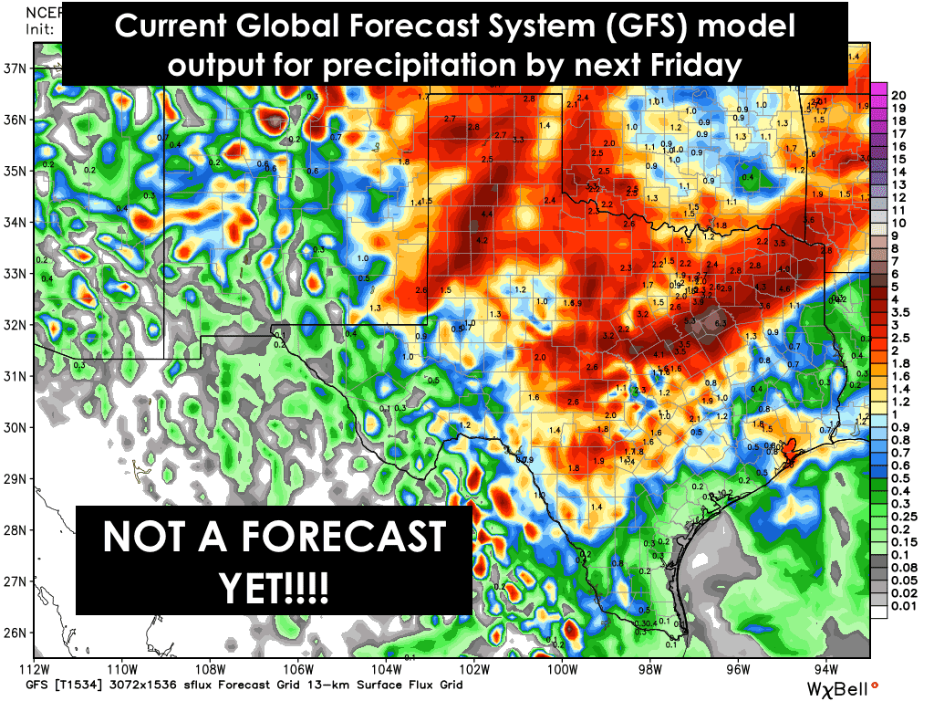
- Attachments
-
-
Carla/Alicia/Jerry(In The Eye)/Michelle/Charley/Ivan/Dennis/Katrina/Rita/Wilma/Humberto/Ike/Harvey
Member: National Weather Association
Facebook.com/Weather Infinity
Twitter @WeatherInfinity
Member: National Weather Association
Facebook.com/Weather Infinity
Twitter @WeatherInfinity
-
srainhoutx
- Site Admin
- Posts: 19616
- Joined: Tue Feb 02, 2010 2:32 pm
- Location: Maggie Valley, NC
- Contact:
The afternoon Update from the Climate Prediction Center is advertising an unsettled pattern continues with a stagnant Southern stream allowing for a continued trough in West with above normal rain chances in the Day 8+ Range.
- Attachments
-
Carla/Alicia/Jerry(In The Eye)/Michelle/Charley/Ivan/Dennis/Katrina/Rita/Wilma/Humberto/Ike/Harvey
Member: National Weather Association
Facebook.com/Weather Infinity
Twitter @WeatherInfinity
Member: National Weather Association
Facebook.com/Weather Infinity
Twitter @WeatherInfinity

Reading the afternoon AFD from the local NWS office...and they are not impressed. Maybe something tomorrow but mostly dry until at least Sunday or Monday. It keeps getting pushed further and further into the future.
Go back and read last week's discussions. It looked so promising.
So much for a wet week. Time to crank the sprinklers, at least for now.
Go back and read last week's discussions. It looked so promising.
So much for a wet week. Time to crank the sprinklers, at least for now.
-
srainhoutx
- Site Admin
- Posts: 19616
- Joined: Tue Feb 02, 2010 2:32 pm
- Location: Maggie Valley, NC
- Contact:
Good to see the Upper Rio Grande, Pecos and the Permian Basin areas getting beneficial rainfall. As for next week, there are some indications that a stalled frontal boundary may be draped across Central, SE, East Texas into Louisiana. We are a far cry from the situation our Region was in back 4 years ago. Even Monterrey, Nuevo León is running near 300% above normal for rainfall...year to date. 
Carla/Alicia/Jerry(In The Eye)/Michelle/Charley/Ivan/Dennis/Katrina/Rita/Wilma/Humberto/Ike/Harvey
Member: National Weather Association
Facebook.com/Weather Infinity
Twitter @WeatherInfinity
Member: National Weather Association
Facebook.com/Weather Infinity
Twitter @WeatherInfinity
Good to hear that. Hope the Western US also benefits as well.srainhoutx wrote:Good to see the Upper Rio Grande, Pecos and the Permian Basin areas getting beneficial rainfall. As for next week, there are some indications that a stalled frontal boundary may be draped across Central, SE, East Texas into Louisiana. We are a far cry from the situation our Region was in back 4 years ago. Even Monterrey, Nuevo León is running near 300% above normal for rainfall...year to date.
-
srainhoutx
- Site Admin
- Posts: 19616
- Joined: Tue Feb 02, 2010 2:32 pm
- Location: Maggie Valley, NC
- Contact:
Showers and some storms continue to move inland off the Gulf. There have been several reports of tropical short lived funnel clouds across Brazoria County which is typical with a surge of tropical moisture moving inland in May. The short range Texas Tech and HRRR (High Resolution Rapid Refresh) guidance suggest scattered showers and storms are likely across portions of Central and SE Texas this afternoon particularly with daytime heating.
Carla/Alicia/Jerry(In The Eye)/Michelle/Charley/Ivan/Dennis/Katrina/Rita/Wilma/Humberto/Ike/Harvey
Member: National Weather Association
Facebook.com/Weather Infinity
Twitter @WeatherInfinity
Member: National Weather Association
Facebook.com/Weather Infinity
Twitter @WeatherInfinity
-
srainhoutx
- Site Admin
- Posts: 19616
- Joined: Tue Feb 02, 2010 2:32 pm
- Location: Maggie Valley, NC
- Contact:
A small but very slow moving strong to severe thunderstorm cell is likely producing flooding across Southern Burleson County. This storm developed yesterday afternoon North of San Antonio and has drifted slowly East during the night dropping 4-8 inches of rainfall near Bastrop. Radar indicates this very heavy rainfall producing thunderstorm may be moving ESE with additional showers spreading inland off the Gulf across Western and Central portions of SE Texas.
Carla/Alicia/Jerry(In The Eye)/Michelle/Charley/Ivan/Dennis/Katrina/Rita/Wilma/Humberto/Ike/Harvey
Member: National Weather Association
Facebook.com/Weather Infinity
Twitter @WeatherInfinity
Member: National Weather Association
Facebook.com/Weather Infinity
Twitter @WeatherInfinity
-
srainhoutx
- Site Admin
- Posts: 19616
- Joined: Tue Feb 02, 2010 2:32 pm
- Location: Maggie Valley, NC
- Contact:
Flash Flood Warning issued for Burleson, Washington and Brazos Counties. The Weather Prediction Center has outlined a Slight Risk for Excessive Rainfall across portions of SE Texas.
- Attachments
-
Carla/Alicia/Jerry(In The Eye)/Michelle/Charley/Ivan/Dennis/Katrina/Rita/Wilma/Humberto/Ike/Harvey
Member: National Weather Association
Facebook.com/Weather Infinity
Twitter @WeatherInfinity
Member: National Weather Association
Facebook.com/Weather Infinity
Twitter @WeatherInfinity
-
srainhoutx
- Site Admin
- Posts: 19616
- Joined: Tue Feb 02, 2010 2:32 pm
- Location: Maggie Valley, NC
- Contact:
From Nesdis:
SATELLITE PRECIPITATION ESTIMATES..DATE/TIME 05/06/15 1216Z
SATELLITE ANALYSIS BRANCH/NESDIS---NPPU---TEL.301-683-1404
LATEST DATA USED: GOES-13 1200Z KUSSELSON
NOAA AMSU:0923Z
.
LOCATION...SE TEXAS...
.
ATTN WFOS...HGX...
ATTN RFCS...WGRFC...
.
EVENT...PACIFIC-GULF OF MEXICO MOISTURE CONNECTION CONTINUES...SO
BURLESON COUNTY CONVECTION TO CONTINUE A BIT LONGER THROUGH BRAZOS AND
GRIMES AND PORTIONS OF SURROUNDING COUNTIES...
.
SATELLITE ANALYSIS AND TRENDS...THOUGH NOT AS POTENT AS DURING THE
NIGHT...STILL A DEFINITE MODERATE PACIFIC MOISTURE ADVECTION CONNECTION
ACROSS CENTRAL MEXICO AT THE MID LEVELS FEEDING INTO LOW LEVEL WESTERN
GULF MOISTURE ADVECTION INTO SE TEXAS TO SUSTAIN HVY RAIN A BIT LONGER
THIS MORNING AND POSSIBLY AS CONVECTIVE CELL CROSSES THE CENTER OF
BRAZOS AND THEN GRIMES COUNTY. LATEST GPS PWAT AT 11Z HAD A 1.6"
VALUE CENTERED ON CONROE, TX AND THAT WELL ABOVE 150 PERCENT OF NORMAL
SHORT TERM OUTLOOK VALID 1215-1515Z...MEDIUM CONFIDENCE FACTOR
IN SHORT TERM OUTLOOK...MOVEMENT AND WEAKENING SHOULD OCCUR BY END OF
THIS PERIOD...BUT STILL CONCERN FOR AREA CENTERED ON BRAZOS AND POSSIBLY
GRIMES AND CLOSE SURROUNDING COUNTIES FOR LOCALLY HVY RAINS BEFORE THAT
HAPPENS...WHAT WITH 1.6" PWATS IN AREA THERE COULD BE HRLY RATES CLOSE
TO THAT FIGURE NEXT HR OR SO.
Carla/Alicia/Jerry(In The Eye)/Michelle/Charley/Ivan/Dennis/Katrina/Rita/Wilma/Humberto/Ike/Harvey
Member: National Weather Association
Facebook.com/Weather Infinity
Twitter @WeatherInfinity
Member: National Weather Association
Facebook.com/Weather Infinity
Twitter @WeatherInfinity
-
srainhoutx
- Site Admin
- Posts: 19616
- Joined: Tue Feb 02, 2010 2:32 pm
- Location: Maggie Valley, NC
- Contact:
Morning briefing from Jeff:
Upper air disturbance this morning resulting in a very slow moving strong to a times severe thunderstorm over the NW counties of SE TX. The storm is currently located over northern Washington County with a second storm moving into southern Brazos County. Main threat appears to be excessive rainfall where Doppler radar indicates upwards of 2.5-4.5 inches of rainfall is occurring with this cell and has occurred over northern Le and much of Burleson Counties this morning.
These storms are slowly moving toward the SE at around 10mph and may move into Grimes/Waller/Montgomery/Harris Counties over the next few hours should they hold together. Favorable low level inflow off the Gulf of Mexico should help to maintain the activity at least for the next hour.
Clearly the air mass across the NW/W portions of the region is fairly unstable this morning and with surface heating today and the potential for weak impulses to move across in the SW flow scattered showers and thunderstorms look possible.
Carla/Alicia/Jerry(In The Eye)/Michelle/Charley/Ivan/Dennis/Katrina/Rita/Wilma/Humberto/Ike/Harvey
Member: National Weather Association
Facebook.com/Weather Infinity
Twitter @WeatherInfinity
Member: National Weather Association
Facebook.com/Weather Infinity
Twitter @WeatherInfinity
-
srainhoutx
- Site Admin
- Posts: 19616
- Joined: Tue Feb 02, 2010 2:32 pm
- Location: Maggie Valley, NC
- Contact:
FLOOD ADVISORY
NATIONAL WEATHER SERVICE HOUSTON/GALVESTON TX
757 AM CDT WED MAY 6 2015
BURLESON TX-WASHINGTON TX-BRAZOS TX-WALLER TX-GRIMES TX-
757 AM CDT WED MAY 6 2015
THE NATIONAL WEATHER SERVICE IN LEAGUE CITY HAS ISSUED A
* FLOOD ADVISORY FOR...
SOUTHEASTERN BURLESON COUNTY IN SOUTHEASTERN TEXAS...
EASTERN WASHINGTON COUNTY IN SOUTHEASTERN TEXAS...
SOUTHEASTERN BRAZOS COUNTY IN SOUTHEASTERN TEXAS...
NORTHWESTERN WALLER COUNTY IN SOUTHEASTERN TEXAS...
SOUTHWESTERN GRIMES COUNTY IN SOUTHEASTERN TEXAS...
* UNTIL 1000 AM CDT
* AT 755 AM CDT...DOPPLER RADAR INDICATED HEAVY RAIN CAUSING MINOR
FLOODING IN THE ADVISORY AREA. UP TO TWO INCHES OF RAIN HAVE
ALREADY FALLEN. AN ADDITIONAL INCH IS LIKELY.
* SOME LOCATIONS THAT WILL EXPERIENCE FLOODING INCLUDE...
COLLEGE STATION...BRENHAM...NAVASOTA...WASHINGTON...MILLICAN...
WELLBORN AND INDEPENDENCE.
Carla/Alicia/Jerry(In The Eye)/Michelle/Charley/Ivan/Dennis/Katrina/Rita/Wilma/Humberto/Ike/Harvey
Member: National Weather Association
Facebook.com/Weather Infinity
Twitter @WeatherInfinity
Member: National Weather Association
Facebook.com/Weather Infinity
Twitter @WeatherInfinity
-
srainhoutx
- Site Admin
- Posts: 19616
- Joined: Tue Feb 02, 2010 2:32 pm
- Location: Maggie Valley, NC
- Contact:
For our neighbors in Central Texas...
FLOOD ADVISORY
NATIONAL WEATHER SERVICE AUSTIN/SAN ANTONIO TX
804 AM CDT WED MAY 6 2015
TRAVIS TX-BASTROP TX-WILLIAMSON TX-LEE TX-
804 AM CDT WED MAY 6 2015
THE NATIONAL WEATHER SERVICE IN AUSTIN SAN ANTONIO HAS ISSUED A
* URBAN AND SMALL STREAM FLOOD ADVISORY FOR...
EASTERN TRAVIS COUNTY IN SOUTH CENTRAL TEXAS...
NORTHERN BASTROP COUNTY IN SOUTH CENTRAL TEXAS...
SOUTHEASTERN WILLIAMSON COUNTY IN SOUTH CENTRAL TEXAS...
NORTHERN LEE COUNTY IN SOUTH CENTRAL TEXAS...
* UNTIL 1100 AM CDT
* AT 801 AM CDT...DOPPLER RADAR AND AUTOMATED RAIN GAUGES INDICATED
EARLIER HEAVY RAINS CAUSING URBAN AND SMALL STREAM FLOODING IN THE
FROM AUSTIN AND BASTROP TO TAYLOR AND DIME BOX. UP TO 7 INCHES OF
RAIN HAVE FALLEN IN THIS AREA. NUMEROUS SMALL STREAMS WILL
CONTINUE TO RUN HIGH WHILE RUNOFF CONTINUES IN URBAN AREAS.
* SOME LOCATIONS THAT WILL EXPERIENCE FLOODING INCLUDE...
AUSTIN...PFLUGERVILLE...ELGIN...BASTROP...LEXINGTON...WINDEMERE...
AUSTIN BERGSTROM INT AP...MANOR...CEDAR CREEK...WYLDWOOD...
TANGLEWOOD...FEDOR...CAMP SWIFT...DIME BOX...CIRCLE D-KC ESTATES...
WEBBERVILLE...DEL VALLE...BLUE...WELLS BRANCH AND MCDADE.
ADDITIONAL RAINFALL OF ONE QUARTER INCH IS EXPECTED OVER THE AREA.
HOWEVER...THIS ADDITIONAL RAIN WILL HAVE MINIMAL IMPACT ON THE MINOR
FLOODING.
Carla/Alicia/Jerry(In The Eye)/Michelle/Charley/Ivan/Dennis/Katrina/Rita/Wilma/Humberto/Ike/Harvey
Member: National Weather Association
Facebook.com/Weather Infinity
Twitter @WeatherInfinity
Member: National Weather Association
Facebook.com/Weather Infinity
Twitter @WeatherInfinity
-
srainhoutx
- Site Admin
- Posts: 19616
- Joined: Tue Feb 02, 2010 2:32 pm
- Location: Maggie Valley, NC
- Contact:
FLOOD ADVISORY
NATIONAL WEATHER SERVICE HOUSTON/GALVESTON TX
851 AM CDT WED MAY 6 2015
WASHINGTON TX-AUSTIN TX-WALLER TX-
851 AM CDT WED MAY 6 2015
THE NATIONAL WEATHER SERVICE IN LEAGUE CITY HAS ISSUED A
* FLOOD ADVISORY FOR...
SOUTHEASTERN WASHINGTON COUNTY IN SOUTHEASTERN TEXAS...
NORTHEASTERN AUSTIN COUNTY IN SOUTHEASTERN TEXAS...
WALLER COUNTY IN SOUTHEASTERN TEXAS...
* UNTIL 1045 AM CDT
* AT 847 AM CDT...DOPPLER RADAR INDICATED A CLUSTER OF STORMS JUST
NORTHWEST OF HEMPSTEAD MOVING SOUTHEAST AROUND 10 MPH. CELLS
WITHIN THIS CLUSTER ARE PRODUCING RAINFALL RATES UP TO 3 INCHES
PER HOUR. THESE HEAVY RATES WILL CAUSE MINOR FLOODING IN THE
ADVISORY AREA.
* SOME LOCATIONS THAT WILL EXPERIENCE FLOODING INCLUDE...
KATY...HEMPSTEAD...PRAIRIE VIEW...BROOKSHIRE...WALLER...PINE
ISLAND...SIMONTON...SAN FELIPE...PATTISON AND MONAVILLE.
Carla/Alicia/Jerry(In The Eye)/Michelle/Charley/Ivan/Dennis/Katrina/Rita/Wilma/Humberto/Ike/Harvey
Member: National Weather Association
Facebook.com/Weather Infinity
Twitter @WeatherInfinity
Member: National Weather Association
Facebook.com/Weather Infinity
Twitter @WeatherInfinity
-
- Information
-
Who is online
Users browsing this forum: Ahrefs [Bot], Semrush [Bot], TexasBreeze and 65 guests