

JULY 2015:Heat Advisory Expanded Across Metro Houston
-
srainhoutx

- Site Admin

- Posts: 19616
- Joined: Tue Feb 02, 2010 2:32 pm
- Location: Maggie Valley, NC
- Contact:
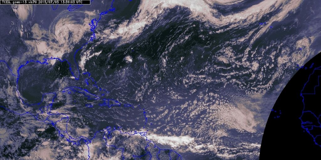
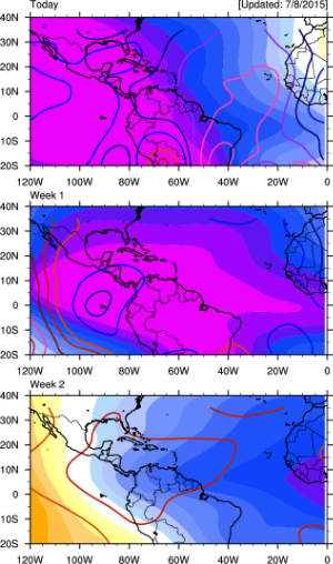
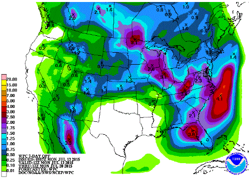
A rather benign and quiet weather pattern is expected this week as the Bermuda Ridge links up with an upper ridge located across Mexico and expands across Texas throughout the coming work week. There is a chance for a few widely scattered isolated heat of the day showers day to day, but the overall sensible weather looks hot and dry across most of Texas into next weekend. No tropical development is expected for the next 5 days across the North Atlantic Basin.
Carla/Alicia/Jerry(In The Eye)/Michelle/Charley/Ivan/Dennis/Katrina/Rita/Wilma/Humberto/Ike/Harvey
Member: National Weather Association
Facebook.com/Weather Infinity
Twitter @WeatherInfinity
Member: National Weather Association
Facebook.com/Weather Infinity
Twitter @WeatherInfinity
-
wxman57

- Global Moderator

- Posts: 2621
- Joined: Thu Feb 04, 2010 5:34 am
- Location: Southwest Houston (Westbury)
- Contact:
Which GFS model are you looking at that goes out to 20 days? Do you have a link to this "McTavish number" or a "PLANFALF" run? Never heard of any of that.Paul Robison wrote:And now, the holiday spoiler:
I've been in contact with a blogger named Grothar on http://www.wunderground.com. As some of you may have noticed, some of the GFS model runs have been hinting at some kind of tropical weather system impacting the Texas coast in 20 days. Now, I'm sure we won't have a good answer until the latest PLANFALF runs comes in. If the McTavish numbers come in line with the PLANFALF, and GFS gets on board, the results could be bad news for our state. Mind everyone, this is about 20 days out but, if everything comes together, we could be looking at a high end cat 4 from this. Unfortunately, cat 5 cannot be ruled out (although they're rare) but, this being an El Nino year, Grothar says the McTavish results are leaning in that direction. Stay Tuned.
Lol What? You don't really believe that right?Paul Robison wrote:And now, the holiday spoiler:
I've been in contact with a blogger named Grothar on http://www.wunderground.com. As some of you may have noticed, some of the GFS model runs have been hinting at some kind of tropical weather system impacting the Texas coast in 20 days. Now, I'm sure we won't have a good answer until the latest PLANFALF runs comes in. If the McTavish numbers come in line with the PLANFALF, and GFS gets on board, the results could be bad news for our state. Mind everyone, this is about 20 days out but, if everything comes together, we could be looking at a high end cat 4 from this. Unfortunately, cat 5 cannot be ruled out (although they're rare) but, this being an El Nino year, Grothar says the McTavish results are leaning in that direction. Stay Tuned.

LOL ... I'll mark my calendar for Jul. 24th Ha ha.
~~~When Thunder Roars Go Indoors~~~
~~~Turn Around Don't Drown~~~
~~~Run From The Water, Hide From The Wind~~~
~~~Turn Around Don't Drown~~~
~~~Run From The Water, Hide From The Wind~~~
-
Paul Robison
I'm not the troll. Just the messenger. Grothar is the troll. But, to be honest, when I got back in touch with Grothar on Wunderground, he later admitted he was playing a joke on me. Hope everyone accepts my apologies.unome wrote:much like the mental disorder of an exhibitionist, some types of internet trolls get pleasure out of "exposing" themselves every now and then... just don't feed the trolls
Now, I will admit that the 20% chance of T-RW on Tuesday does make me a little apprehensive. What can anyone tell me about that?
-
Texaspirate11

- Posts: 1278
- Joined: Tue Dec 31, 2013 12:24 am
- Contact:
Paul,
When I knew very little about weather I began at the WU. It was really good to begin with then fell into trolls who were basically 15 and lived in their parent's basements in Cleveland and wishcast for Cat 5's.
I do know of Grothar and he seems very legit. Again I don't know him personally or his professional background - if any. Perhaps he said the tropics will come alive in due time. It is the hurricane season. Just be careful what you read over there.
The wonderful thing about this forum is the professionalism and facts that are presented. Such as from wxman57 and srainhoutx You can take their information seriously.
I would also appreciate it if name calling and assumptions about mental disorders were stricken from this forum. Let's keep it professional and fact based. If you have an issue with my statement, come directly to me.
Thanks - enjoy this very hot week - I know, as a sun worshipper I am game.
Just because you're disabled, you don't have to be a victim
Be Weather Aware & Prepared!
Barbara Jordan Winner in Media
Disability Integration Consultant
Be Weather Aware & Prepared!
Barbara Jordan Winner in Media
Disability Integration Consultant
-
srainhoutx
- Site Admin
- Posts: 19616
- Joined: Tue Feb 02, 2010 2:32 pm
- Location: Maggie Valley, NC
- Contact:
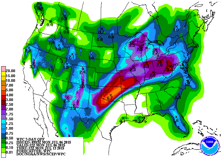
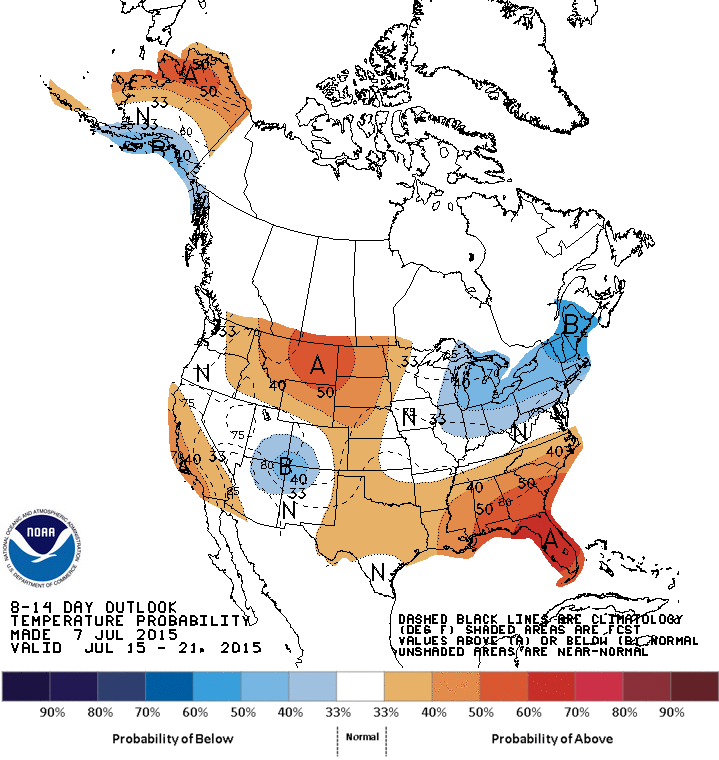
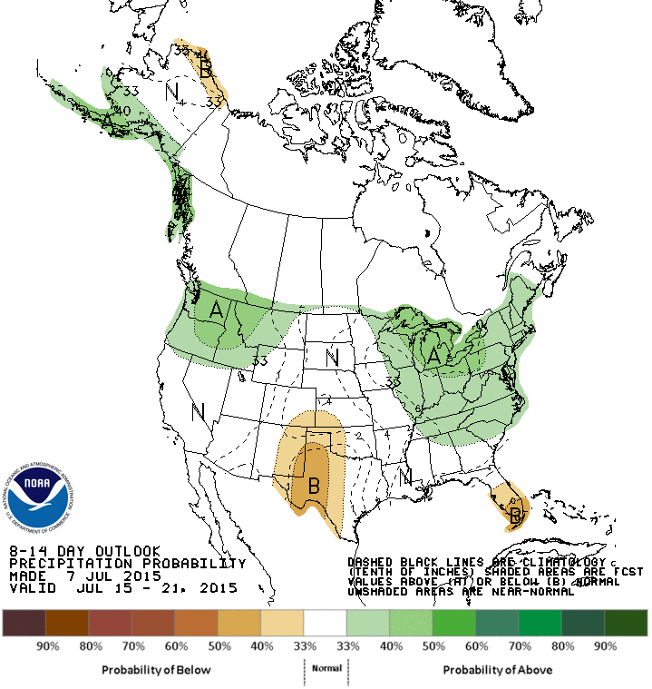
The upcoming work week weather appears to be rather benign across most of Texas into Louisiana, but may offer a wrinkle or two as the weekend approaches. The upper ridge that has brought subsidence and heat to our Region will not have a great influence other than to briefly dry us out and let temperature creep up to what we typically expect to see in early to mid July. It will feel hot with the heat index being high due to all the soil moisture content from the abundant rains we have received this year, but not oppressively hot like 2011 when we were in the mist of a full blown drought feedback upper ridge that was relentless for days on end and we could not buy a cloud in the sky. Flash Flood Watches are hoisted across the Plains into portions of Missouri where heavy training rainfall is expected along that wavy front.
A rather pesky upper low is spinning off of California and should move inland this week while shortwaves drop S out of Canada into the Northern Plains sparking daily rounds of severe storms along a wavy frontal boundary across the Colorado/Wyoming front range into the Central and Southern Plains on North and East. A TUTT ( tropical upper tropospheric trough) low is noted spinning East of the Bahamas and slowly moving W.
The Tropical Western Pacific Basin remains very active with a high amplitude Phase 7 MJO assisting in tropical development in that part of the world as well as a robust CCKW (Convectively Coupled Kelvin Wave) that continues to advance E across the Central and Eastern Pacific Ocean.
Showers and storm chances may increase a bit toward the weekend as PW's increase to near or slightly above the 2 inch mark setting the stage for isolated to scattered showers/storms to give a brief reprieve from the heat.
Carla/Alicia/Jerry(In The Eye)/Michelle/Charley/Ivan/Dennis/Katrina/Rita/Wilma/Humberto/Ike/Harvey
Member: National Weather Association
Facebook.com/Weather Infinity
Twitter @WeatherInfinity
Member: National Weather Association
Facebook.com/Weather Infinity
Twitter @WeatherInfinity
-
srainhoutx
- Site Admin
- Posts: 19616
- Joined: Tue Feb 02, 2010 2:32 pm
- Location: Maggie Valley, NC
- Contact:
Morning briefing from Jeff:
What appeared to be a straight forward forecast of hot and mostly dry weather this week is starting to show some signs of changes.
Upper level ridging over FL will begin to build westward and exert more and more influence over SE TX weather with the development of more subsidence under the ridging and weak capping. As was the case yesterday, the subsidence is just too much to overcome and little if any showers/thunderstorms developed over the region. Progs yesterday were to anchor the ridging over TX much of this week, but today is a little different story in this historically wet 2015.
PW this morning of 1.60 inches suggest little chance for thunderstorms today along with weak subsidence and capping. A weak short wave will move across the southern plains on Tuesday and moisture will slightly increase, so a slight chance of afternoon thunderstorms will be needed in the forecast. Ridging then really establishes Wednesday and Thursday with rain chances likely no zero. Afternoon temperatures will rise under increasing subsidence, but green vegetation and still wet grounds will help mitigate the increase. Interestingly BUSH IAH has yet to hit 95 degrees this summer.
Biggest changes appear to be Friday-Sunday as upper level ridge builds northward into the plains allowing SE TX to come under the influence of the easterly flow on its underside. Deep tropical moisture looks to surge into the area from the east along with a weak disturbance so rain chances will be introduced on Friday and likely continue into the weekend. Still some disagreement on the exact position of the upper level high and how much influence it will have over SE TX, but will side with the wetter solution as thus far in 2015 any attempts to shut off rainfall have not succeeded.
Overall likely some of the warmest temperatures thus far this summer this week with highs in the low to mid 90’s and lows in the mid to upper 70’s. Afternoon heat index values will push 100-105 each afternoon.
Carla/Alicia/Jerry(In The Eye)/Michelle/Charley/Ivan/Dennis/Katrina/Rita/Wilma/Humberto/Ike/Harvey
Member: National Weather Association
Facebook.com/Weather Infinity
Twitter @WeatherInfinity
Member: National Weather Association
Facebook.com/Weather Infinity
Twitter @WeatherInfinity
-
srainhoutx
- Site Admin
- Posts: 19616
- Joined: Tue Feb 02, 2010 2:32 pm
- Location: Maggie Valley, NC
- Contact:
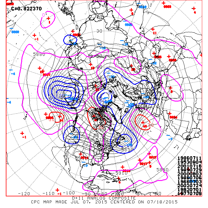
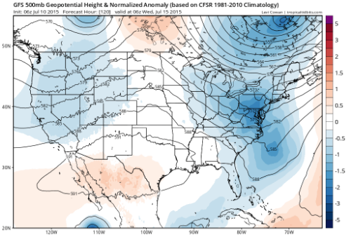
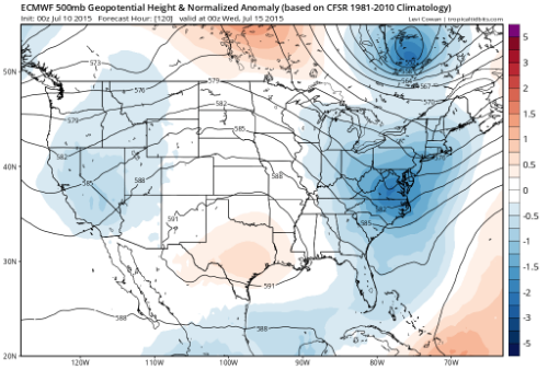
No significant change regarding the sensible weather we can expect throughout this week. The upper ridge looks to meander W across the Southern US with the possibility of a slight increase in moisture sliding from Florida beneath the upper ridge toward Louisiana and Texas by Friday. There are growing indications that this pattern will be transitory and break down next week as a lot of tropical activity develops across the Eastern Pacific fairly close to Mexico. In fact the 12Z European suggests a strong Hurricane paralleling the Pacific Coast of Mexico next week. The various computer schemes suggest lowering pressures across the NW Gulf of Mexico by mid to late next week further increasing the possibility of daily showers and storms. The longer range guidance appears to be trending to a more unsettled pattern mid July and beyond, if those longer range computer schemes are correct.


Carla/Alicia/Jerry(In The Eye)/Michelle/Charley/Ivan/Dennis/Katrina/Rita/Wilma/Humberto/Ike/Harvey
Member: National Weather Association
Facebook.com/Weather Infinity
Twitter @WeatherInfinity
Member: National Weather Association
Facebook.com/Weather Infinity
Twitter @WeatherInfinity
-
srainhoutx
- Site Admin
- Posts: 19616
- Joined: Tue Feb 02, 2010 2:32 pm
- Location: Maggie Valley, NC
- Contact:
The heavy rainfall that has brought relief from the heat across the Central portion of the Lone Star State into Oklahoma will slowly move out as an upper ridge builds across New Mexico and Taos through the weekend into early next week. Hot and humid weather is on tap with the 'feels like' temperatures rising above the Century mark throughout the weekend and early next week. Resent rainfall should keep the actual temperatures across Central and SE Texas in the mid 90's or near to slightly above climatology for mid July across the Region. Relief from the heat and rainfall chances look to increase by mid next week as the upper ridge breaks down and the pattern chances from a trough in the West to that of a developing weak trough across the SE United States and along the Gulf Coast. It appears moisture begins to arrive next week from the NW Caribbean across the NW Gulf as several upper air disturbances ride the upper flow S from Canada into our neck of the woods. A robust Convectively Coupled Kelvin Wave also begins to arrive in the Western Atlantic Basin during this timeframe further assisting in increasing shower and storm development. The Eastern Pacific looks to become very active with several opportunities for tropical development West of the Pacific Coast of Mexico. The longer range guidance continues to advertise increasing showers and storms across the Middle and Upper Texas Coast into Louisiana as we near the 3rd weekend of July. Drink plenty of water when outdoors the next several days as the heat index will be near 105F across some locations.

Carla/Alicia/Jerry(In The Eye)/Michelle/Charley/Ivan/Dennis/Katrina/Rita/Wilma/Humberto/Ike/Harvey
Member: National Weather Association
Facebook.com/Weather Infinity
Twitter @WeatherInfinity
Member: National Weather Association
Facebook.com/Weather Infinity
Twitter @WeatherInfinity
-
srainhoutx
- Site Admin
- Posts: 19616
- Joined: Tue Feb 02, 2010 2:32 pm
- Location: Maggie Valley, NC
- Contact:
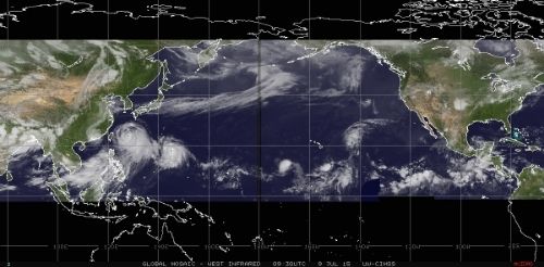
Moisture levels are slowly advancing W across the Northern Gulf as well as from the Bay of Campeche toward Coastal Louisiana and Texas. African dust that has plagued our Region should begin to finally filter out over the next day or two as the upper ridge builds across Texas bringing blue skies and warmer temperatures. There is an isolated chance for heat of the day storms Friday into Saturday before the upper ridge anchors across W Texas and subsidence takes control eliminating any chance of rain until at least mid next week. The computer models remain somewhat blurry regarding our next chance of appreciable rainfall, but it looks like we may see a surge of tropical moisture later next week. The next surge of Saharan dust moving across the Atlantic appears to be heading further S into the Yucatan Peninsula and Central America next week, so perhaps we can finally say goodbye to the haze for a while. The Atlantic Basin continues to be very quiet...topically speaking...but expect the Eastern Pacific to erupt with at least a couple of strong Hurricanes next week as the Convectively Coupled Kelvin Wave continues marching east across the Pacific towards Mexico and eventually into the Western Atlantic Basin. A parade of tropical cyclones continue to march W across the Pacific Ocean from China to near the Pacific Coast of Mexico.
Carla/Alicia/Jerry(In The Eye)/Michelle/Charley/Ivan/Dennis/Katrina/Rita/Wilma/Humberto/Ike/Harvey
Member: National Weather Association
Facebook.com/Weather Infinity
Twitter @WeatherInfinity
Member: National Weather Association
Facebook.com/Weather Infinity
Twitter @WeatherInfinity
-
srainhoutx
- Site Admin
- Posts: 19616
- Joined: Tue Feb 02, 2010 2:32 pm
- Location: Maggie Valley, NC
- Contact:
No change in the summer doldrums regarding the weather news across our Region. Isolated heat of the day showers and storms may attempt to develop mainly along the seabreeze today and tomorrow before the upper ridge plants across Texas and shuts down any chance of rainfall. This heat ridge will not be as strong as years past due to the abundant rainfall we have seen this year, but it will bring the 'hottest' temperatures we have seen so far this summer. No real change in the medium range forecast into mid next week as the ridge remains in control. There could be an slight increase in rain chances later next week as the upper ridge breaks down and a powerful Eastern Pacific Hurricane organizing offshore of the West Coast of Mexico S of the Gulf of Tehuantepec parallels the Coast remaining safely offshore.

Carla/Alicia/Jerry(In The Eye)/Michelle/Charley/Ivan/Dennis/Katrina/Rita/Wilma/Humberto/Ike/Harvey
Member: National Weather Association
Facebook.com/Weather Infinity
Twitter @WeatherInfinity
Member: National Weather Association
Facebook.com/Weather Infinity
Twitter @WeatherInfinity
that rain was heavenly & felt like much more than what's reflected via local gages, perhaps because it was unexpected & most welcome. whatever the reason, so glad it dropped, mother nature's version soaks in so much better than watering the lawn 
http://www.harriscountyfws.org/
http://weather.cod.edu/satrad/nexrad/in ... -N0Q-1-200
http://www.harriscountyfws.org/
http://weather.cod.edu/satrad/nexrad/in ... -N0Q-1-200
-
Katdaddy

- Global Moderator
- Posts: 2502
- Joined: Thu Feb 04, 2010 8:18 am
- Location: League City, Tx
- Contact:
Hot and humid weather to continue through the week.
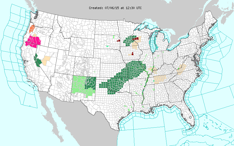
THIS HAZARDOUS WEATHER OUTLOOK IS FOR PORTIONS OF SOUTHEAST TEXAS.
.DAY ONE...TODAY AND TONIGHT
A WARM AND HUMID AIRMASS WILL BE IN PLACE TODAY WITH MAXIMUM
TEMPERATURES IN THE MID 90S. THIS WILL YEILD HEAT INDEX VALUES
APPROACHING 105F. REMEMBER TO STAY HYDRATED AND TAKE PLENTY OF
BREAKS IF ENGAGING IN ANY OUTSIDE ACTIVITIES.
.DAYS TWO THROUGH SEVEN...TUESDAY THROUGH SUNDAY
TEMPERATURES WILL LIKELY REACH THE MID 90S TO UPPER 90S EACH DAY
THIS WEEK FOR HIGH TEMPERATURES. COMBINED WITH THE HUMID
AIRMASS...MAX AFTERNOON HEAT INDEX VALUES NEAR 105 DEGREES WILL BE
POSSIBLE. REMEMBER TO STAY HYDRATED AND TAKE PLENTY OF BREAKS IF
ENGAGING IN ANY OUTSIDE ACTIVITIES.
-
srainhoutx
- Site Admin
- Posts: 19616
- Joined: Tue Feb 02, 2010 2:32 pm
- Location: Maggie Valley, NC
- Contact:
No real relief from the heat and dry conditions seen in the medium/long range guidance until possibly next week when the upper ridge shifts West into the Desert SW of NW Mexico, Arizona and Nevada. Until then, the Upper Ridge is firmly anchored over Texas and the Southern Plains. While it will be hot and dry, this is nothing like what we experienced back in 2011 when we were in the grip of a devastating drought across the Region and there was zero soil or vegetation moisture to be absorbed. Drink plenty of water and stay hydrated during this extended period of hot and dry weather. Check of those that are elderly and those that may not have air conditioning to keep them cool frequently.
Carla/Alicia/Jerry(In The Eye)/Michelle/Charley/Ivan/Dennis/Katrina/Rita/Wilma/Humberto/Ike/Harvey
Member: National Weather Association
Facebook.com/Weather Infinity
Twitter @WeatherInfinity
Member: National Weather Association
Facebook.com/Weather Infinity
Twitter @WeatherInfinity
71 days until official start of Autumn. Instead of complaining about the heat which I dislike. I am counting down to Autumn cooler temps and everything pumpkin LOL.
-
MontgomeryCoWx

- Posts: 2356
- Joined: Wed Dec 14, 2011 4:31 pm
- Location: Weimar, TX
- Contact:
You are crazy wxman57 but I respsect your love for the hellish days of Summer! 
I'm counting down the days until Autumn too... Cooler temps, Tailgating and College Football!
I'm counting down the days until Autumn too... Cooler temps, Tailgating and College Football!
Team #NeverSummer