
Morning briefing from Jeff:
Upper level high pressure ridge has anchored over TX clearly evident in the clockwise cloud pattern over the southern plains and the building heights.
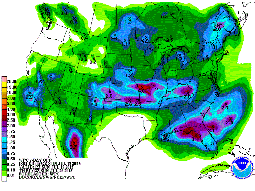
End result of this building ridge has been to nearly completely remove rain chances from the forecast and allow day to day slow building of heat in the lower atmosphere. Overall air mass is fairly dry with PWS falling toward 1.5 inches and a subsidence inversion in the mid level helping to cap the air mass. General sinking air will allow for little development of deep cumulus or showers/thunderstorms for this week. Main forecast concern will be the heat as ground moisture slowly depletes allowing better heating. Green vegetation is still bringing some feedback processes against the building heat, but expect afternoon high temperatures to gradually rise into the mid to upper 90’s this week. Mixing down of drier air aloft by late morning should help prevent heat index values from getting out of control…at least not expecting 108 to result in an advisory for the area. Could start getting close by the end of the week with a little more moisture arriving, but temperatures might also cool a degree or two by then as the ridge builds slightly to the NE.
Rain chances will be near 0 for the next few days and maybe 10% by the end of the week, but overall the outlook for the next 5-10 days supports little rainfall with the ridge remaining over TX. Ridging and deep layer flow will help keep the Saharan dust layer which has plagued the region of late to our south and aimed more at Mexico.
JULY 2015:Heat Advisory Expanded Across Metro Houston
-
srainhoutx

- Site Admin

- Posts: 19616
- Joined: Tue Feb 02, 2010 2:32 pm
- Location: Maggie Valley, NC
- Contact:
Carla/Alicia/Jerry(In The Eye)/Michelle/Charley/Ivan/Dennis/Katrina/Rita/Wilma/Humberto/Ike/Harvey
Member: National Weather Association
Facebook.com/Weather Infinity
Twitter @WeatherInfinity
Member: National Weather Association
Facebook.com/Weather Infinity
Twitter @WeatherInfinity
-
srainhoutx
- Site Admin
- Posts: 19616
- Joined: Tue Feb 02, 2010 2:32 pm
- Location: Maggie Valley, NC
- Contact:
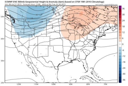
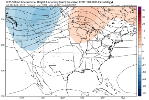
The various reliable computer schemes are in good agreement suggesting the upper ridge will remain anchored over Texas into the coming weekend. As we begin next week subtle changes begin to develop suggesting the ridge will shift West into NE Mexico and Arizona bring a NW flow aloft to our Region in about a week. The GFS and European guidance is advertising remnant moisture from Hurricane Dolores in the Eastern Pacific may begin to be pulled East into California this coming weekend and ride above the Westward shifting upper ridge and eventually SE with the NW flow aloft overhead. There are indications that Gulf Moisture will increase as well and possibly bring an end to our dry weather particularly across Oklahoma into the Eastern half of Texas into Louisiana by mid next week.
Carla/Alicia/Jerry(In The Eye)/Michelle/Charley/Ivan/Dennis/Katrina/Rita/Wilma/Humberto/Ike/Harvey
Member: National Weather Association
Facebook.com/Weather Infinity
Twitter @WeatherInfinity
Member: National Weather Association
Facebook.com/Weather Infinity
Twitter @WeatherInfinity
-
srainhoutx
- Site Admin
- Posts: 19616
- Joined: Tue Feb 02, 2010 2:32 pm
- Location: Maggie Valley, NC
- Contact:
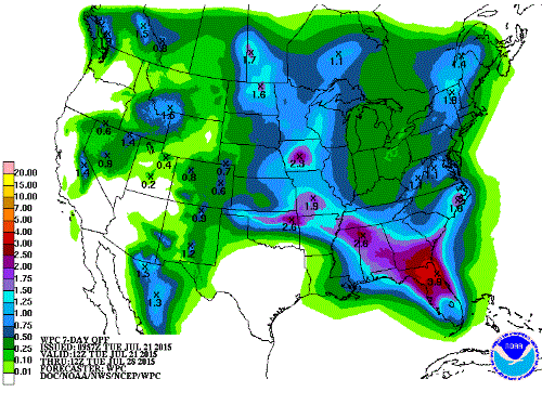
No change in the sensible forecast across Texas and the Southern Plains into the weekend and through most of next week in the extended range. The pesky upper ridge remains anchored across our Region and is actually very typical of an El Nino summer pattern in July. Will continue to carry little if any chance of appreciable rainfall during the next 5 to 7 days except near the Coast early-mid next week where we may see an increase in tropical moisture and an isolated chance of seabreeze showers/storms, but hot and dry remains the theme for most during the next 7 or so days.
The tropical Atlantic remains quiet and no tropical development is expected during the next 5 days. The Eastern Pacific is a different story where Major Hurricane Dolores continues to move WNW safely away from the Baja Peninsula, but is generating powerful waves along the West facing beaches of Los Cabos. The various computer guidance do indicate at least another powerful Hurricane developing S of the Gulf of Tehuantepec next week paralleling the Pacific Coast of Mexico.
For our Region, we may see the pesky upper ridge build NW later next week allowing for some rain chances to begin to slowly increase as pressures slowly begin to lower across the Western Gulf of Mexico, but that is too far out to know with any certainty regarding what our sensible weather may bring. Meanwhile stay hydrated this weekend as we will likely see the hottest temperature of the summer season.
Carla/Alicia/Jerry(In The Eye)/Michelle/Charley/Ivan/Dennis/Katrina/Rita/Wilma/Humberto/Ike/Harvey
Member: National Weather Association
Facebook.com/Weather Infinity
Twitter @WeatherInfinity
Member: National Weather Association
Facebook.com/Weather Infinity
Twitter @WeatherInfinity
-
Texaspirate11

- Posts: 1278
- Joined: Tue Dec 31, 2013 12:24 am
- Contact:
wxman57 wrote:I spent all weekend outside, washing/painting the front of the house and enjoying the near-normal July temperatures. Ah, the best time of the year!
Agree!!!! 90 and up is heaven!
Just because you're disabled, you don't have to be a victim
Be Weather Aware & Prepared!
Barbara Jordan Winner in Media
Disability Integration Consultant
Be Weather Aware & Prepared!
Barbara Jordan Winner in Media
Disability Integration Consultant
-
srainhoutx
- Site Admin
- Posts: 19616
- Joined: Tue Feb 02, 2010 2:32 pm
- Location: Maggie Valley, NC
- Contact:
We may see a brief reprieve from the hot and dry pattern of the past 7 days today as some increase in moisture moving West across the Gulf beneath the upper ridge arrives across the Upper Texas Coast and SW Louisiana. Radar is detecting scattered showers and storms over the Coastal waters this morning and the SPC is indicating a general chance for garden variety thunderstorm development today mainly along and S of the I-10 Corridor. The pesky upper ridge meanders over Texas Saturday into early next week with continued hot and dry conditions, but there are increasing hints that the flat upper ridge moves N and W by mid next week allowing increasing chances of daytime showers and storms to develop later next week. The longer range guidance suggests that the upper ridge will anchor its self over the Central Rockies and the Central Plains next weekend with possibly an Easterly wave moving West across the Northern Gulf toward Texas beneath that upper ridge. This may mark the beginning of a pattern change across our Region as a combination of Eastern Pacific tropical activity close to the Pacific Coast of Mexico and increasing moisture from the Western Caribbean push toward the Western Gulf allowing a return to a bit of an unsettled pattern as we near the end of July. We will see... 
Carla/Alicia/Jerry(In The Eye)/Michelle/Charley/Ivan/Dennis/Katrina/Rita/Wilma/Humberto/Ike/Harvey
Member: National Weather Association
Facebook.com/Weather Infinity
Twitter @WeatherInfinity
Member: National Weather Association
Facebook.com/Weather Infinity
Twitter @WeatherInfinity
Bring that pattern change on - rain and cooler temps. Autumn is fast approaching...
-
GBinGrimes

- Posts: 108
- Joined: Mon Jan 27, 2014 1:50 pm
- Location: Anderson, TX
- Contact:
This may be one of those things that whomever reads it will ask "is he nuts?" but here goes anyway...
There's a cell tower a couple of pastures to the west of us where the sun sets that we use to gauge the changing of seasons (along with the temps and weather of course). We watch the sunsets move towards the tower from spring into summer. The sun then sets to the south of it when the high summer is upon us and as we move into fall and winter the sun sets well north of it.
What has become interesting to me is that we are in mid July and the setting sun has already moved farther north of the tower than I have ever seen it in July. To me, it's in a late August, early September position. The earth does wobble on it's axis and this different position of the setting sun has me wondering 2 things: 1 - Perhaps I AM nuts!! 2 - If this is indeed an axis wobble and the sun is farther north than typical could this be the foretelling of a very chilly winter?
Just thought I would throw that out there while we're in the midst of summer's repeating daily forecast.
Y'all have a great day!
-
srainhoutx
- Site Admin
- Posts: 19616
- Joined: Tue Feb 02, 2010 2:32 pm
- Location: Maggie Valley, NC
- Contact:
The pesky upper ridge continues to remain anchored over Texas into early this week before sliding W into New Mexico by mid week and possibly giving our Region a brief reprieve from the hot and dry conditions that brought high heat indices and isolated showers for a lucky few. By late week into next weekend shower and storm chances could increase a bit as the upper air pattern shifts further W and a trough over the NE Gulf allows for some increasing moisture to move W into Coastal Texas and Louisiana.
The longer range guidance suggests that high pressure pushes NW back into the Western Gulf and Texas late in July while a potential tropical disturbance begins to organize off the SE United States Coast and possibly develops into Danny that could pose a threat to South Carolina/North Carolina as the month of July nears an end. Stay hydrated and take breaks from the hot July sun this week. The 'dog days' of summer look to continue as we end the month of July.

A quick mention of the early outlooks for Fall suggest that El Nino continues developing with increasing chances of rainfall by September and 'cooler' temperatures arrive as the Pacific becomes active and pressures begin to lower across the Western United States into Texas and dreams of that first Fall cold front begin to enter our weather conversations in what may be a very busy Fall and Winter across our Region. Until then...stay cool...
The longer range guidance suggests that high pressure pushes NW back into the Western Gulf and Texas late in July while a potential tropical disturbance begins to organize off the SE United States Coast and possibly develops into Danny that could pose a threat to South Carolina/North Carolina as the month of July nears an end. Stay hydrated and take breaks from the hot July sun this week. The 'dog days' of summer look to continue as we end the month of July.
A quick mention of the early outlooks for Fall suggest that El Nino continues developing with increasing chances of rainfall by September and 'cooler' temperatures arrive as the Pacific becomes active and pressures begin to lower across the Western United States into Texas and dreams of that first Fall cold front begin to enter our weather conversations in what may be a very busy Fall and Winter across our Region. Until then...stay cool...
Carla/Alicia/Jerry(In The Eye)/Michelle/Charley/Ivan/Dennis/Katrina/Rita/Wilma/Humberto/Ike/Harvey
Member: National Weather Association
Facebook.com/Weather Infinity
Twitter @WeatherInfinity
Member: National Weather Association
Facebook.com/Weather Infinity
Twitter @WeatherInfinity
-
wxman57

- Global Moderator

- Posts: 2621
- Joined: Thu Feb 04, 2010 5:34 am
- Location: Southwest Houston (Westbury)
- Contact:
Had about 12" of rain downtown over the weekend - that is, 12" between raindrops on my wife's windshield. Spent Friday washing my house and Saturday biking (4 hours). I think my legs are more tired from climbing up and down the ladder than from the biking. No sign of a pattern change yet. Just over 2 months of summer to go...
And, hopefully how quickly that 2 months of summer will pass! Just 2 months ago we were struggling with excessive rainfall. I'm hoping by Sept. 20, I'm thinking about stocking up on some firewood! 
-
wxman57
- Global Moderator
- Posts: 2621
- Joined: Thu Feb 04, 2010 5:34 am
- Location: Southwest Houston (Westbury)
- Contact:
Unfortunately (for me), El Nino winters are often cold and wet along the Gulf Coast - with an increased chance of frozen precipitation. I don't mind an occasional snowfall down here, it's the days and days of 30s or 40s and rain that I hate.
-
Paul Robison
srainhoutx wrote:The pesky upper ridge continues to remain anchored over Texas into early this week before sliding W into New Mexico by mid week and possibly giving our Region a brief reprieve from the hot and dry conditions that brought high heat indices and isolated showers for a lucky few. By late week into next weekend shower and storm chances could increase a bit as the upper air pattern shifts further W and a trough over the NE Gulf allows for some increasing moisture to move W into Coastal Texas and Louisiana.
http://i228.photobucket.com/albums/ee29 ... 45a46e.gif
The longer range guidance suggests that high pressure pushes NW back into the Western Gulf and Texas late in July while a potential tropical disturbance begins to organize off the SE United States Coast and possibly develops into Danny that could pose a threat to South Carolina/North Carolina as the month of July nears an end. Stay hydrated and take breaks from the hot July sun this week. The 'dog days' of summer look to continue as we end the month of July.
http://www.ssd.noaa.gov/goes/comp/ceus/wv-animated.gif
A quick mention of the early outlooks for Fall suggest that El Nino continues developing with increasing chances of rainfall by September and 'cooler' temperatures arrive as the Pacific becomes active and pressures begin to lower across the Western United States into Texas and dreams of that first Fall cold front begin to enter our weather conversations in what may be a very busy Fall and Winter across our Region. Until then...stay cool...
But future "Danny" could be our] storm. From Accuweather:
Waters along the southeastern United States coast may become the breeding grounds for tropical development in the Atlantic Basin during the last week in July.
A front is forecast to stall over the region this week and into next week. While many tropical systems tend to form from disturbances moving westward off the coast of Africa, a small number can form in the vicinity of a stalled front over warm water.
Steamy Conditions over the Gulf and Atlantic Could get Tricky
This area of concern stretches from Gulf of Mexico waters, west of Florida, to Atlantic Ocean coastal waters from northeast of Florida to Georgia and the Carolinas.
The forecast broad area of disturbed weather could allow one or possibly two tropical systems to slowly organize in the coming days.
According to AccuWeather Hurricane Expert Dan Kottlowski, "Provided winds aloft remain light over this area, there could be an opportunity for tropical development."
Kottlowski pointed out that if a system were to develop off the southern Atlantic Coast of the U.S., then steering winds could take the system out to sea.
If a system were to develop on the Gulf side, steering winds could allow such a system meander westward along the upper Gulf coast. (Our way?)
Residents and vacationers in the Gulf and Southeast should monitor the situation this weekend and into next week.
"Throughout the region of concern, water temperatures are sufficiently warm to support tropical development," Kottlowski said.
Either system would tend to move slowly and could bring torrential rainfall to part of the Southeast coast.
Should a system develop, then the risk of offshore seas, rough surf and strong rip currents will increase.
AccuWeather.com will continue to provide updates on this area of concern and other tropical systems across the globe.
The question here is: will it be Hurricane Alicia Part II?
-
srainhoutx
- Site Admin
- Posts: 19616
- Joined: Tue Feb 02, 2010 2:32 pm
- Location: Maggie Valley, NC
- Contact:
No threat of any tropical troubles for the Western Gulf at this time and only a very slim if any chance of rainfall for a very lucky few for the next week.
Carla/Alicia/Jerry(In The Eye)/Michelle/Charley/Ivan/Dennis/Katrina/Rita/Wilma/Humberto/Ike/Harvey
Member: National Weather Association
Facebook.com/Weather Infinity
Twitter @WeatherInfinity
Member: National Weather Association
Facebook.com/Weather Infinity
Twitter @WeatherInfinity

I keep checking in daily, just to get more depressed with each update.

-
srainhoutx
- Site Admin
- Posts: 19616
- Joined: Tue Feb 02, 2010 2:32 pm
- Location: Maggie Valley, NC
- Contact:
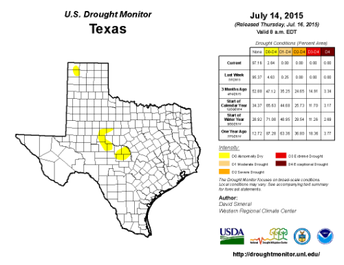
Why depressed? Now the summer of 2011 was one we all can agree was depressing. We couldn't buy a rain cloud and when a tropical system developed, we experienced wildfires. Days and days of endless 100+F and not a drop of rain to be found. Texas is officially out of a drought for the first time since it began back in the Fall/early Winter of 2008-2009. For that I am thankful. This upper ridge is nothing like what we've experienced in the past. The pattern will change soon enough. It isn't that long until the rain returns and cold front tracking begins once again...Rip76 wrote:I keep checking in daily, just to get more depressed with each update.
Carla/Alicia/Jerry(In The Eye)/Michelle/Charley/Ivan/Dennis/Katrina/Rita/Wilma/Humberto/Ike/Harvey
Member: National Weather Association
Facebook.com/Weather Infinity
Twitter @WeatherInfinity
Member: National Weather Association
Facebook.com/Weather Infinity
Twitter @WeatherInfinity

I HEAR THUNDER!!!!! (hope I didn't just jinx it)...... 
-
BiggieSmalls

- Posts: 92
- Joined: Thu Feb 04, 2010 10:05 am
- Location: Dallas, Texas
- Contact:
Bring on another few months of sun and 0 rain please....we've had more than enough clouds/rain for the year as far as I'm concerned