

They formed a beautiful bend in the eastern sky in CLL. A sign of things to come later this week.Katdaddy wrote:The SW LA outflow boundary is slowly pushing into SE TX but will weaken as the Summer heat begins to decrease. If you look E and NE of Houston this evening you will see the high cirrus clouds. Perhaps a 9PM gust front if you are lucky along and E of the I-45 Gulf Freeway corridor.
JULY 2015:Heat Advisory Expanded Across Metro Houston


Storms coming from the east happen in the Summer. Usually they come from the west or northwest.Rip76 wrote:Seems to happen a lot with storms coming in from the East.

Correct.
I meant, storms coming in from the East tend to die out as they head toward Houston.
Most likely firing up because of daytime heating, but unable to reach us.
I meant, storms coming in from the East tend to die out as they head toward Houston.
Most likely firing up because of daytime heating, but unable to reach us.
Smith Point, TX weather report...
HOT and Hot with some mixed Hotter

HOT and Hot with some mixed Hotter
And, Walker County has now put into place a "Burn Ban" effective, today (07/27/2015) at noon. It's feast or famine around here....
-
srainhoutx

- Site Admin

- Posts: 19616
- Joined: Tue Feb 02, 2010 2:32 pm
- Location: Maggie Valley, NC
- Contact:
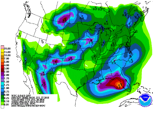
Unfortunately, it's not looking too promising in the rainfall potential as of this afternoon late this week into the weekend. That frontal boundary looks to hang up over the Piney Woods of East Texas Thursday into Friday, but the Eastern Gulf moisture may stay closer to the Coast and offshore of the Upper Texas Coast into SW Louisiana. Fingers crossed we can get some relief after a hot and dry July.
Carla/Alicia/Jerry(In The Eye)/Michelle/Charley/Ivan/Dennis/Katrina/Rita/Wilma/Humberto/Ike/Harvey
Member: National Weather Association
Facebook.com/Weather Infinity
Twitter @WeatherInfinity
Member: National Weather Association
Facebook.com/Weather Infinity
Twitter @WeatherInfinity
-
Katdaddy

- Global Moderator

- Posts: 2502
- Joined: Thu Feb 04, 2010 8:18 am
- Location: League City, Tx
- Contact:
Hot weather to continue with only a slight increase in isolated afternoon showers as weak cool front drifts into SE TX Thursday through Saturday. Thunderstorms continue to pulse over the EGOM each day but not a current threat for tropical development. The dog days of Summer continue.
-
srainhoutx
- Site Admin
- Posts: 19616
- Joined: Tue Feb 02, 2010 2:32 pm
- Location: Maggie Valley, NC
- Contact:
We need to monitor the area of moisture and sheared convection West of Tampa Bay later in the week into the weekend. There are some indications that mid level energy (700mb) breaks off and heads W towards Texas and a weak frontal boundary nears East Texas and Central Louisiana. While no tropical development is expected, it could bring increased moisture to our part of the world and I am not so sure the computer models have a good handle on this feature. We will see.

Carla/Alicia/Jerry(In The Eye)/Michelle/Charley/Ivan/Dennis/Katrina/Rita/Wilma/Humberto/Ike/Harvey
Member: National Weather Association
Facebook.com/Weather Infinity
Twitter @WeatherInfinity
Member: National Weather Association
Facebook.com/Weather Infinity
Twitter @WeatherInfinity
-
srainhoutx
- Site Admin
- Posts: 19616
- Joined: Tue Feb 02, 2010 2:32 pm
- Location: Maggie Valley, NC
- Contact:
Morning briefing from Jeff:
Upper ridge has built NE the last few days allowing a slightly more moist air mass to invade the region and give rise to a few isolated afternoon thunderstorms. Should see a similar setup today and again on Wednesday.
Upper ridge will then shift westward into the SW US by Thursday as a trough deepens over the US E coast allowing a frontal boundary to slide southward and reach the area on Thursday. Compressional heating ahead of this boundary may spike high temperatures on Thursday to 100 or above prior to the onset of convective development. Moisture pooling along the advancing boundary coupled with hot afternoon temperatures will likely result in at least scattered late afternoon and evening thunderstorms over the region moving from NE to SW on the eastern flank of the upper level ridge. Boundary actually appears that it may push through the area and into the Gulf of Mexico by late Friday. Friday will feature another chance of showers and thunderstorms before drier air moves into the region from the north.
Drier air mass filtering in for the weekend looks to result in potentially some of the hottest weather of 2015 as a dry air mass heats much more quickly than a moist air mass. Latest GFS shows 100 and 101 for IAH both Saturday and Sunday. Will not go that warm just yet as rains on Thursday and Friday may help to negate the temperature rise some. However, should wetting rains remain isolated or scattered and not widespread then low 100’s for afternoon temperatures over the weekend seem possible.
Boundary, moisture, and lowered pressures will move out over the Gulf of Mexico over the weekend and remain in place into early next week. Will go with a dry forecast after Friday.
Note: After one of the wettest Spring periods on record, the .44 of an inch of rainfall in July at BUSH IAH is currently the 2nd driest July on record.
Carla/Alicia/Jerry(In The Eye)/Michelle/Charley/Ivan/Dennis/Katrina/Rita/Wilma/Humberto/Ike/Harvey
Member: National Weather Association
Facebook.com/Weather Infinity
Twitter @WeatherInfinity
Member: National Weather Association
Facebook.com/Weather Infinity
Twitter @WeatherInfinity

Gotta love Texas weather. The faucet got shut off when July started and someone turned the oven on!!!! LOL. Hot Town Summer In The City ........ 
~~~When Thunder Roars Go Indoors~~~
~~~Turn Around Don't Drown~~~
~~~Run From The Water, Hide From The Wind~~~
~~~Turn Around Don't Drown~~~
~~~Run From The Water, Hide From The Wind~~~
-
brooksgarner

- Global Moderator
- Posts: 226
- Joined: Tue Jun 04, 2013 3:06 pm
- Location: Houston, TX
- Contact:
NHC looking at a very distant tropical wave, forecast with a 20% to develop over next few days... El Nino is strong, so if this system follows with our pattern over the Atlantic so far, it has little chance, if any. http://www.nhc.noaa.gov/gtwo.php?basin=atlc&fdays=5
Broadcast Met
http://BrooksGarner.com
http://twitter.com/BrooksWeather
http://BrooksGarner.com
http://twitter.com/BrooksWeather
- '17 Harvey
- '12 Sandy (P3 Orion)
- '91 Bob
- '85 Gloria
If it travels due west for the next 2 to 3 days, I think it has a chance to reach TS, but any movement north during that time it hits a lot of dry air (SAL).brooksgarner wrote:NHC looking at a very distant tropical wave, forecast with a 20% to develop over next few days... El Nino is strong, so if this system follows with our pattern over the Atlantic so far, it has little chance, if any. http://www.nhc.noaa.gov/gtwo.php?basin=atlc&fdays=5
-
brooksgarner
- Global Moderator
- Posts: 226
- Joined: Tue Jun 04, 2013 3:06 pm
- Location: Houston, TX
- Contact:
For that tropical wave off of Africa -- yes there is lots of SAL dry air and future shear. NHC says "30% chance" now... but--
I'm more interested in this Gulf Stream, heavily-sheared, but spinning surface low... If shear dissipates this would be a TS pretty fast.
I'm more interested in this Gulf Stream, heavily-sheared, but spinning surface low... If shear dissipates this would be a TS pretty fast.
Broadcast Met
http://BrooksGarner.com
http://twitter.com/BrooksWeather
http://BrooksGarner.com
http://twitter.com/BrooksWeather
- '17 Harvey
- '12 Sandy (P3 Orion)
- '91 Bob
- '85 Gloria
-
Texaspirate11

- Posts: 1278
- Joined: Tue Dec 31, 2013 12:24 am
- Contact:
brooksgarner wrote:For that tropical wave off of Africa -- yes there is lots of SAL dry air and future shear. NHC says "30% chance" now... but--
I'm more interested in this Gulf Stream, heavily-sheared, but spinning surface low... If shear dissipates this would be a TS pretty fast.
I'm developing Florida envy....
Just because you're disabled, you don't have to be a victim
Be Weather Aware & Prepared!
Barbara Jordan Winner in Media
Disability Integration Consultant
Be Weather Aware & Prepared!
Barbara Jordan Winner in Media
Disability Integration Consultant
Keep an eye on this one.brooksgarner wrote:For that tropical wave off of Africa -- yes there is lots of SAL dry air and future shear. NHC says "30% chance" now... but--
I'm more interested in this Gulf Stream, heavily-sheared, but spinning surface low... If shear dissipates this would be a TS pretty fast.
-
srainhoutx
- Site Admin
- Posts: 19616
- Joined: Tue Feb 02, 2010 2:32 pm
- Location: Maggie Valley, NC
- Contact:
Rain chances look to increase today into Friday as the pesky upper ridge begins to nudge West and a weak frontal boundary approaches Central and SE Texas into Louisiana. Moisture levels increase to around 2.2 inches suggesting a strong gusty thunderstorm or two are possible. Heat indices will remain high and may approach Heat Advisory criteria with ambient temperatures near 100F. Moisture from the Northern Gulf creeps West toward East and Central Texas from Louisiana, but pesky subsidence from the upper ridge may limit widespread rain chances. The European model has trended a bit 'wetter' in agreement with the NAM lending a slightly better support of additional storms chances on Friday as the frontal boundary sags south to around the I-10 Corridor. There is an outside chance of a brief pulse up heat of the day severe thunderstorm or two, but areal coverage looks somewhat limited. Rain chances may need to be extended into the weekend, with slightly cooler temperatures due to cloud debris, but we will cover that in the August Topic as we end the month of July on Friday.
Carla/Alicia/Jerry(In The Eye)/Michelle/Charley/Ivan/Dennis/Katrina/Rita/Wilma/Humberto/Ike/Harvey
Member: National Weather Association
Facebook.com/Weather Infinity
Twitter @WeatherInfinity
Member: National Weather Association
Facebook.com/Weather Infinity
Twitter @WeatherInfinity
-
srainhoutx
- Site Admin
- Posts: 19616
- Joined: Tue Feb 02, 2010 2:32 pm
- Location: Maggie Valley, NC
- Contact:
Briefing from Jeff last evening:
Upper ridge resulting in now two days straight of 100 degree temperatures in Houston…missed the record high of 101 today…will shift slightly westward allowing for a better chance of thunderstorms Thursday afternoon.
Upper ridge shifting slightly westward on Thursday will allow a weak frontal boundary to move into SE TX late in the afternoon from the NNE. Surface temperatures will soar toward 100 prior to the onset of convection likely after 300-400pm from Lake Charles NNW toward Lufkin. Upper level steering winds toward the SW will bring storms developing in that region toward SE TX into the later afternoon and evening hours. Air mass over SE TX will be extremely hot with surface temperatures in the upper 90’s/low 100’s. SW moving thunderstorms into super-heated SE TX air masses this time of year tend to produce strong winds as the sub-cloud layer can be fairly dry…ie afternoon RH at IAH today was only 33%. Will keep coverage 30-40% so not everyone is going to get much needed rainfall.
Note: KBDI values continue to rise across the region and with incoming convective activity and a decent chance of cloud to ground lightning, the potential for grass fires will be elevated. Fine fuels continue to rapidly deteriorate under strong heating and lack of top soil moisture levels. KBDI values over 600-700 from Huntsville to Liberty County support near critical fire weather concerns with lightning and gusty thunderstorm outflow winds.
Extended:
Could see another shot at afternoon thunderstorms on Friday mainly south of I-10 and possibly more right near the coast with a drier air mass moving southward. This will set the stage for a hot weekend as dewpoints fall allowing the local air mass to behave much closer to a desert condition. 100+ temperatures seem in store both Saturday and Sunday, but heat index values will not be more worse than the air temperature given lowered dewpoints.
Bad news is that after Thursday and Friday rain chances fall to near 10% again for the next several days. Fire weather concerns will certainly grow due to lack of widespread wetting rainfall and quickly worsening vegetation health.
Will at least have to watch the frontal boundary and associated low pressure trough over the Gulf of Mexico next week for any potential organization.
Carla/Alicia/Jerry(In The Eye)/Michelle/Charley/Ivan/Dennis/Katrina/Rita/Wilma/Humberto/Ike/Harvey
Member: National Weather Association
Facebook.com/Weather Infinity
Twitter @WeatherInfinity
Member: National Weather Association
Facebook.com/Weather Infinity
Twitter @WeatherInfinity
Quite a few boundaries heading this way from the East popping up showers and storms. Would be nice to get a nice downpour to cool the temps down a bit! Fingers crossed.
-
BlueJay
- Posts: 938
- Joined: Tue Mar 04, 2014 10:47 am
- Location: Alden Bridge-The Woodlands, Texas
- Contact:
We got some thunder and our driveway is dampened. Although there is no measurable rain so far, the temperature has fallen down to a cooler 86F!
I am beginning to think that we will end this month with only 0.75 inches of rain.
I am beginning to think that we will end this month with only 0.75 inches of rain.
-
- Information
-
Who is online
Users browsing this forum: Ahrefs [Bot], Bing [Bot], Semrush [Bot] and 71 guests