
August 2015 - Isolated Rain Chances to End August
Starting the August thread since we have a week left before August starts? Will the dog days continue with heat or will rain appear in our forecast soon? 
-
srainhoutx

- Site Admin

- Posts: 19616
- Joined: Tue Feb 02, 2010 2:32 pm
- Location: Maggie Valley, NC
- Contact:
The afternoon Update from the Climate Prediction Center suggests a more typical late July/early August pattern returns with increasing rain chances and typical summertime warm temperatures.
Carla/Alicia/Jerry(In The Eye)/Michelle/Charley/Ivan/Dennis/Katrina/Rita/Wilma/Humberto/Ike/Harvey
Member: National Weather Association
Facebook.com/Weather Infinity
Twitter @WeatherInfinity
Member: National Weather Association
Facebook.com/Weather Infinity
Twitter @WeatherInfinity
-
Paul Robison
Glad to hear it, Srainhoutex. Keep up the good work!srainhoutx wrote:The afternoon Update from the Climate Prediction Center suggests a more typical late July/early August pattern returns with increasing rain chances and typical summertime warm temperatures.
-
srainhoutx
- Site Admin
- Posts: 19616
- Joined: Tue Feb 02, 2010 2:32 pm
- Location: Maggie Valley, NC
- Contact:
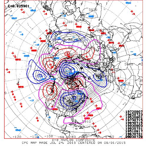
The various computer schemes continue to advertise a bit of a pattern change as we begin August. The pesky upper ridge is expected to flatten out and shift West as a rather potent storm system crosses the Northern Plains this week and heights lower across the Eastern half of the United States with the potential of a frontal boundary nearing East Texas and Louisiana by next weekend. Deep tropical moisture has been pooling across the Eastern Gulf and looks to begin to trek West as the ridge and its subsidence shifts into the Great Basin allowing both seabreeze showers and storms to increase as well as the potential for storms developing near the meandering frontal boundary. The temperatures should moderate as well, but PW's near or slightly above 2 inches should keep things muggy and perhaps unsettled most of next weekend. We could use some rainfall and perhaps we will finally see showers and storms increase in areal coverage as we begin the month of August.
Carla/Alicia/Jerry(In The Eye)/Michelle/Charley/Ivan/Dennis/Katrina/Rita/Wilma/Humberto/Ike/Harvey
Member: National Weather Association
Facebook.com/Weather Infinity
Twitter @WeatherInfinity
Member: National Weather Association
Facebook.com/Weather Infinity
Twitter @WeatherInfinity
-
srainhoutx
- Site Admin
- Posts: 19616
- Joined: Tue Feb 02, 2010 2:32 pm
- Location: Maggie Valley, NC
- Contact:
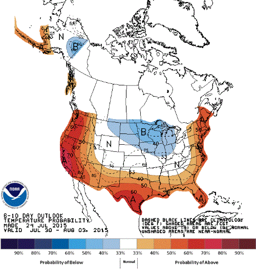
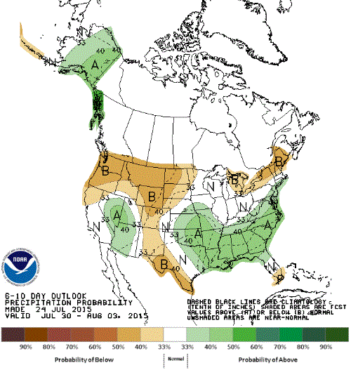
As a new month begins it appears the upper ridge will build back into our Region and hot and dry conditions return at least for the first week or two of August. It is noteworthy that the Pacific looks to become rather topically active from the Eastern Pacific into the Western Pacific which may begin to reshuffle the upper air pattern around mid August. Some of the longer range guidance suggests that a rather deep trough develops across the Eastern half of the United States, but there is far too much uncertainty to hang your hat on any significant changes regarding our sensible weather at this time. As we begin that time of year when the kids return to school and we begin the process of ramping up toward peak season in the Tropical Atlantic, we will continue to monitor for any 'home brew' tropical troubles that may develop.
Two other items of interest worthy of mention. The good folks at KHOU fixed some bugs in our platform yesterday and you will notice that imagery can be uploaded once again. It was discovered that we need a major Upgrade to our platform, but we will hold off on that very intensive Upgrade until after Tropical Season so we do not experience any downtime or loose any data. Thank you Doug Delony for all your efforts! Also on a personal note...I will be traveling to Hawaii mid August for some much needed rest and relaxation and possibly covering any potential tropical troubles for our 50th State during my stay. The Eastern and Central Pacific are expected to be very active as El Nino continues to develop and if Hawaii should be threatened, I will provide live Updates during my stay. Fingers crossed it is a quiet bucket list vacation though...
Two other items of interest worthy of mention. The good folks at KHOU fixed some bugs in our platform yesterday and you will notice that imagery can be uploaded once again. It was discovered that we need a major Upgrade to our platform, but we will hold off on that very intensive Upgrade until after Tropical Season so we do not experience any downtime or loose any data. Thank you Doug Delony for all your efforts! Also on a personal note...I will be traveling to Hawaii mid August for some much needed rest and relaxation and possibly covering any potential tropical troubles for our 50th State during my stay. The Eastern and Central Pacific are expected to be very active as El Nino continues to develop and if Hawaii should be threatened, I will provide live Updates during my stay. Fingers crossed it is a quiet bucket list vacation though...
Carla/Alicia/Jerry(In The Eye)/Michelle/Charley/Ivan/Dennis/Katrina/Rita/Wilma/Humberto/Ike/Harvey
Member: National Weather Association
Facebook.com/Weather Infinity
Twitter @WeatherInfinity
Member: National Weather Association
Facebook.com/Weather Infinity
Twitter @WeatherInfinity
-
Paul Robison
Bon voyage, my friend.srainhoutx wrote:As a new month begins it appears the upper ridge will build back into our Region and hot and dry conditions return at least for the first week or two of August. It is noteworthy that the Pacific looks to become rather topically active from the Eastern Pacific into the Western Pacific which may begin to reshuffle the upper air pattern around mid August. Some of the longer range guidance suggests that a rather deep trough develops across the Eastern half of the United States, but there is far too much uncertainty to hang your hat on any significant changes regarding our sensible weather at this time. As we begin that time of year when the kids return to school and we begin the process of ramping up toward peak season in the Tropical Atlantic, we will continue to monitor for any 'home brew' tropical troubles that may develop.
Two other items of interest worthy of mention. The good folks at KHOU fixed some bugs in our platform yesterday and you will notice that imagery can be uploaded once again. It was discovered that we need a major Upgrade to our platform, but we will hold off on that very intensive Upgrade until after Tropical Season so we do not experience any downtime or loose any data. Thank you Doug Delony for all your efforts! Also on a personal note...I will be traveling to Hawaii mid August for some much needed rest and relaxation and possibly covering any potential tropical troubles for our 50th State during my stay. The Eastern and Central Pacific are expected to be very active as El Nino continues to develop and if Hawaii should be threatened, I will provide live Updates during my stay. Fingers crossed it is a quiet bucket list vacation though...
-
srainhoutx
- Site Admin
- Posts: 19616
- Joined: Tue Feb 02, 2010 2:32 pm
- Location: Maggie Valley, NC
- Contact:
What a pleasant morning out there. Dewpoints down into the 60's for most areas and temperatures running from the upper 60's to low/mid 70's for most. Enjoy it while it lasts! Buoy observations S of the Sabine River suggest a weak surface low may be attempting to develop along the stalled frontal boundary and trough axis that extends NE into Northern Florida. Some of the computer models have suggested this may occur, but no tropical development is expect at this time.

Carla/Alicia/Jerry(In The Eye)/Michelle/Charley/Ivan/Dennis/Katrina/Rita/Wilma/Humberto/Ike/Harvey
Member: National Weather Association
Facebook.com/Weather Infinity
Twitter @WeatherInfinity
Member: National Weather Association
Facebook.com/Weather Infinity
Twitter @WeatherInfinity

So no concern about that area SE of Louisiana?
-
Paul Robison
Opinion post:
Our current Texas heat wave isn’t a "doomsday" (hate that word!) event, obviously, but there are some tough questions I think we (pro mets and moderators) will have to ask eventually if the heat continues, such as:
1. Will we be talking about rationing electricity at some point?
2. What effect on drinking water supplies will the heat eventually have?
3. Will Texas have to scale back its farming?
IMPORTANT: This post is not intended for drama or trolling, but I'd like to know what the forum thinks.
-
srainhoutx
- Site Admin
- Posts: 19616
- Joined: Tue Feb 02, 2010 2:32 pm
- Location: Maggie Valley, NC
- Contact:
This is a typical El Nino pattern for our Region during July into mid August. In fact most of the past El Nino years had hot and dry conditions during the heart of summer. Tomorrow morning will be very pleasant after the month of July we endured. As August ends and September begins, wave lengths tend to get shorter and unsettled weather returns. Enjoy the quiet regime while it lasts. Rainy and chilly weather will be back before we know it.
Carla/Alicia/Jerry(In The Eye)/Michelle/Charley/Ivan/Dennis/Katrina/Rita/Wilma/Humberto/Ike/Harvey
Member: National Weather Association
Facebook.com/Weather Infinity
Twitter @WeatherInfinity
Member: National Weather Association
Facebook.com/Weather Infinity
Twitter @WeatherInfinity
-
Paul Robison
Hmm. Interesting. Thanx, srainhoutex. Anyone else have an opinion?srainhoutx wrote:This is a typical El Nino pattern for our Region during July into mid August. In fact most of the past El Nino years had hot and dry conditions during the heart of summer. Tomorrow morning will be very pleasant after the month of July we endured. As August ends and September begins, wave lengths tend to get shorter and unsettled weather returns. Enjoy the quiet regime while it lasts. Rainy and chilly weather will be back before we know it.


One of the driest summer is 1997. That was during a strong and developing El Nino.srainhoutx wrote:This is a typical El Nino pattern for our Region during July into mid August. In fact most of the past El Nino years had hot and dry conditions during the heart of summer. Tomorrow morning will be very pleasant after the month of July we endured. As August ends and September begins, wave lengths tend to get shorter and unsettled weather returns. Enjoy the quiet regime while it lasts. Rainy and chilly weather will be back before we know it.
Well, surprisingly enough, the past two mornings have actually been very pleasant outside. I love these very subtle hints that cooler weather is on it's way. They are fleeting; but, they are here! 
-
nuby3
- Posts: 387
- Joined: Mon Feb 22, 2010 10:25 pm
- Location: THE WOODLANDS PARKWAY and FM 2978
- Contact:
looking at this radar from florida. just an interesting little spin. thought you guys might have a good opinion
http://radar.weather.gov/radar.php?rid= ... 1&loop=yes
http://radar.weather.gov/radar.php?rid= ... 1&loop=yes
-
Paul Robison
Something to worry about?
From HGX disco:
DISCUSSION...
THE DRY AIRMASS WILL BEGIN TO SLIGHTLY MODIFY LATER TONIGHT AS THE
WINDS BECOME MORE OUT OF THE SOUTHEAST ALTHOUGH THE WINDS WILL
BECOME LIGHT AND HELP KEEP THE CHANGE RATE DOWN UNTIL MONDAY.
BECAUSE OF THIS...WENT WITH SOME HIGHER OVERNIGHT LOWS TOWARD THE
COASTAL COUNTIES BUT WENT WITH 60S IN THE NORTHEASTERN COUNTIES.
OTHERWISE...THE UPPER LEVEL RIDGE WILL BUILD IN AS THE WARM FRONT
MOVES INLAND ON MONDAY AND TUESDAY. SOME ISOLATED SHOWERS OR
THUNDERSTORMS WILL BE POSSIBLE RIGHT ALONG AND OFF THE COAST ON
MONDAY AS FORECASTED BY THE NAM12...GFS...AND ECMWF. WITH THE
STRENGTHENING RIDGE ALOFT...RAIN CHANCES WILL DROP TO 10 PERCENT
OR LESS ON TUESDAY EXCEPT FOR EASTERN CHAMBERS AND LIBERTY
COUNTIES. THE REST OF THE WEEK WILL LIKELY EXPERIENCE DAYTIME
HIGHS IN THE UPPER 90S TO AROUND 100 AND HEAT INDICES IN THE 100
TO 107 RANGE.
These heat indices bother me.
-
srainhoutx
- Site Admin
- Posts: 19616
- Joined: Tue Feb 02, 2010 2:32 pm
- Location: Maggie Valley, NC
- Contact:
The surface low has been designated INVEST 95L. Should move NE across Northern Florida into SE Georgia the next 24 to 36 hours.nuby3 wrote:looking at this radar from florida. just an interesting little spin. thought you guys might have a good opinion
http://radar.weather.gov/radar.php?rid= ... 1&loop=yes
Carla/Alicia/Jerry(In The Eye)/Michelle/Charley/Ivan/Dennis/Katrina/Rita/Wilma/Humberto/Ike/Harvey
Member: National Weather Association
Facebook.com/Weather Infinity
Twitter @WeatherInfinity
Member: National Weather Association
Facebook.com/Weather Infinity
Twitter @WeatherInfinity
-
Katdaddy

- Global Moderator

- Posts: 2502
- Joined: Thu Feb 04, 2010 8:18 am
- Location: League City, Tx
- Contact:
A slight chance of thunderstorms are possible along the coastal areas as a weak warm front drifts N over the NW GOM. Current radar shows some showers and thunderstorms offshore. Across inland areas of SE TX expect continued hot temps under mostly sunny skies.
-
srainhoutx
- Site Admin
- Posts: 19616
- Joined: Tue Feb 02, 2010 2:32 pm
- Location: Maggie Valley, NC
- Contact:
Our neighbors in the Tampa Bay area are taking it on the chin this morning with Major Flooding issues from a weak tropical disturbance (95L) that has moved inland across that area.

- Attachments
-
Carla/Alicia/Jerry(In The Eye)/Michelle/Charley/Ivan/Dennis/Katrina/Rita/Wilma/Humberto/Ike/Harvey
Member: National Weather Association
Facebook.com/Weather Infinity
Twitter @WeatherInfinity
Member: National Weather Association
Facebook.com/Weather Infinity
Twitter @WeatherInfinity