
March 2016 - Progressive Changeable Weather To End The Month

Now I'm confused. Several of you are saying this was a complete bust. Meteorologists here in the golden triangle are still saying everything is still a go and will progress eastward and with heating the storms will begin to fire up and fill in to our area. Is the system still expected to bring us the flooding rains or not now? Someone please clarify. Personally I feel the system only has slowed and instead of the main event happening overnight instead will happen today noon and beyond.
Mike
Beaumont, TX
(IH-10 & College Street)
Beaumont, TX
(IH-10 & College Street)
http://www.spc.noaa.gov/products/md/md0195.html

MESOSCALE DISCUSSION 0195
NWS STORM PREDICTION CENTER NORMAN OK
0729 AM CST WED MAR 09 2016
AREAS AFFECTED...DEEP S INTO SERN TX
CONCERNING...SEVERE POTENTIAL...WATCH POSSIBLE
VALID 091329Z - 091530Z
PROBABILITY OF WATCH ISSUANCE...60 PERCENT
SUMMARY...PERIODIC STRONG TO SEVERE STORMS ARE EXPECTED TO PERSIST
ACROSS MUCH OF SRN AND COASTAL TX THROUGH MORNING...WITH WIND AND
HAIL THE MAIN THREATS. AN ISOLATED TORNADO IS POSSIBLE AS WELL
ESPECIALLY OVER SERN TX INTO SWRN LA LATER TODAY.
DISCUSSION...AN AREA OF THUNDERSTORMS CONTINUES TO MOVE NEWD JUST
AHEAD AND ALONG AN ADVANCING FRONT/OUTFLOW FROM NW OF HOUSTON INTO
NWRN LA. THESE STORMS HAVE ONLY SHOWN PERIODIC STRONG CORES...AND
LITTLE OR NO ROTATION/MESOCYCLONES DESPITE STRONG LOW-LEVEL SHEAR.
IT IS LIKELY THAT LOW-LEVEL STRETCHING IS FAIRLY WEAK DUE TO
RELATIVELY COOL BOUNDARY LAYER BELOW THE LFC. HOWEVER...A
CONDITIONAL TORNADO THREAT EXISTS GIVEN THE STRONG SHEAR AND AMPLE
INSTABILITY...SHOULD FORCING BECOME MORE FAVORABLE EITHER ALONG THE
BOUNDARY ITSELF...WITH POCKETS OF HEATING...OR ANY MESO LOW THAT CAN
FORM.
TO THE S...MORE ROBUST STORMS WITH HIGH ECHO TOPS AND HAIL CORES ARE
DEVELOPING IN CLUSTERS ACROSS DEEP S TX...WITH MOVEMENT PARALLEL TO
THE UPPER FLOW IN A NNEWD DIRECTION. MORNING SOUNDINGS SHOW AMPLE
INSTABILITY AND DEEP LAYER SHEAR FOR A THREAT OF ORGANIZED STORMS AS
THEY CONTINUE NNEWD TOWARD THE MIDDLE TX COAST AND POSSIBLY
EVENTUALLY PIVOTING NEWD TOWARD SERN TX WHERE MODEL CONSENSUS
INDICATES PERIODIC STORMS THROUGH THE DAY. IN THE SHORT
TERM...SOMEWHAT MORE STABLE AIR EXISTS ALONG THE MIDDLE TX COAST
WHICH MAY LIMIT THE NWD PROGRESSION OF THE S TX ACTIVITY.
..JEWELL/CORFIDI.. 03/09/2016
ATTN...WFO...LCH...SHV...HGX...CRP...EWX...BRO...
LAT...LON 26109846 28149911 29349797 31789470 31749388 31259324
30499312 29619354 29089485 28439606 27819689 27019723
26319742 25909770 26109846
Last edited by unome on Wed Mar 09, 2016 7:45 am, edited 2 times in total.
-
nuby3
- Posts: 387
- Joined: Mon Feb 22, 2010 10:25 pm
- Location: THE WOODLANDS PARKWAY and FM 2978
- Contact:
djmike wrote:Now I'm confused. Several of you are saying this was a complete bust. Meteorologists here in the golden triangle are still saying everything is still a go and will progress eastward and with heating the storms will begin to fire up and fill in to our area. Is the system still expected to bring us the flooding rains or not now? Someone please clarify. Personally I feel the system only has slowed and instead of the main event happening overnight instead will happen today noon and beyond.
I believe what you believe - the storm is slower
http://radar.weather.gov/radar.php?rid= ... 1&loop=yes
radar from corpus

Bust on timing, for sure, but not necessarily on rainfall. It's definitely not over.
There is a front draped just NW of the US-59 corridor. The ULL is still well to our SW. That's pretty concerning and will set the stage for heavy rainfall to focus along it today. FWIW the setup we have this morning looks a lot like what was modeled a few days ago, with a stationary front on top of us, except it's a day later - Wednesday instead of Tuesday.
There is a front draped just NW of the US-59 corridor. The ULL is still well to our SW. That's pretty concerning and will set the stage for heavy rainfall to focus along it today. FWIW the setup we have this morning looks a lot like what was modeled a few days ago, with a stationary front on top of us, except it's a day later - Wednesday instead of Tuesday.
Little Cypress Creek at Becker Road
http://www.harriscountyfws.org/GageDetail/Index/1230
Stream Elevation for sensor 1233 is 192.88'
Reading on 3/9/2016 7:09 AM
(top of bank is less than 195')
http://www.harriscountyfws.org/GageDetail/Index/1230
Stream Elevation for sensor 1233 is 192.88'
Reading on 3/9/2016 7:09 AM
(top of bank is less than 195')
-
srainhoutx

- Site Admin

- Posts: 19616
- Joined: Tue Feb 02, 2010 2:32 pm
- Location: Maggie Valley, NC
- Contact:
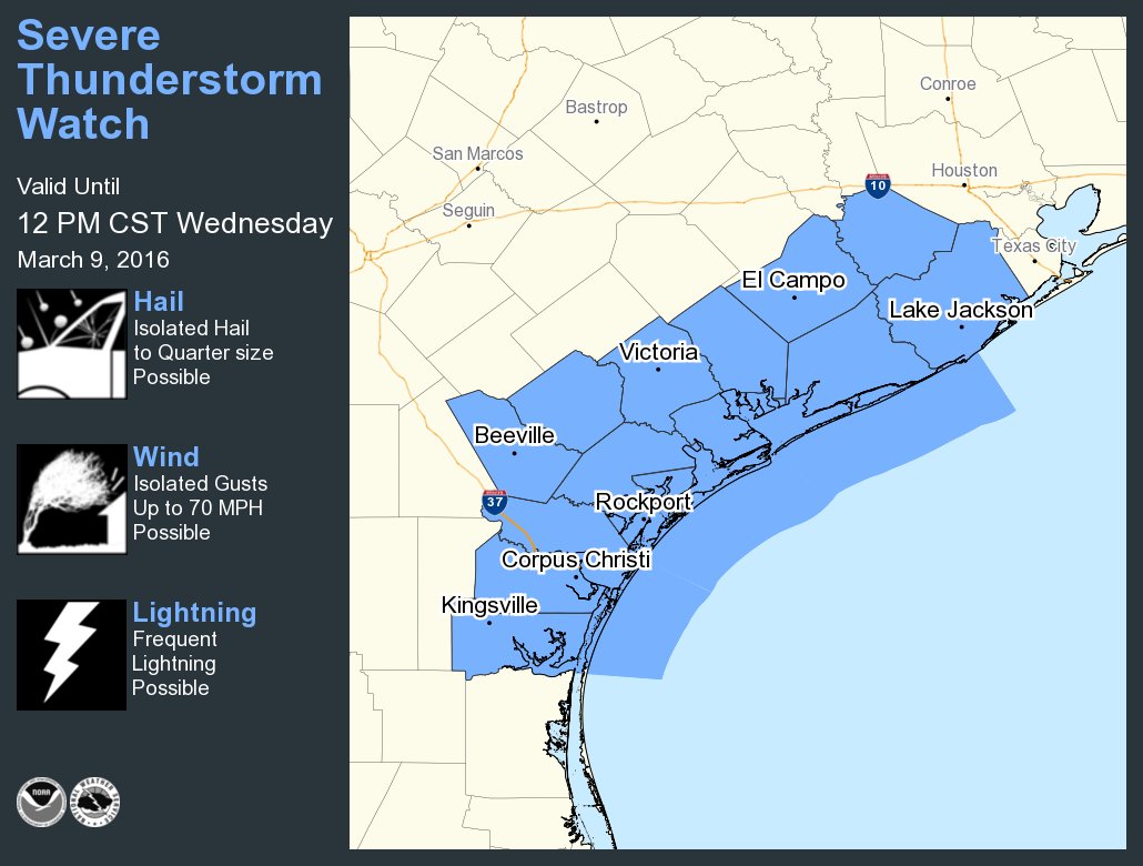
Severe Thunderstorm Watch coming for Jackson, Wharton, Ft. Bend, Matagorda & Brazoria until noon.
Carla/Alicia/Jerry(In The Eye)/Michelle/Charley/Ivan/Dennis/Katrina/Rita/Wilma/Humberto/Ike/Harvey
Member: National Weather Association
Facebook.com/Weather Infinity
Twitter @WeatherInfinity
Member: National Weather Association
Facebook.com/Weather Infinity
Twitter @WeatherInfinity
@NWSHouston
NWSHouston Retweeted NWS Severe Tstorm
A Severe Thunderstorm Watch is in effect for Brazoria, Ft Bend, Jackson, Matagorda, Wharton until 12 PM #txwx
https://twitter.com/NWSSevereTstorm/sta ... 7957354496
@NWSSevereTstorm
A severe thunderstorm watch has been issued for parts of Texas until 12 PM CST
NWSHouston Retweeted NWS Severe Tstorm
A Severe Thunderstorm Watch is in effect for Brazoria, Ft Bend, Jackson, Matagorda, Wharton until 12 PM #txwx
https://twitter.com/NWSSevereTstorm/sta ... 7957354496
@NWSSevereTstorm
A severe thunderstorm watch has been issued for parts of Texas until 12 PM CST
-
srainhoutx
- Site Admin
- Posts: 19616
- Joined: Tue Feb 02, 2010 2:32 pm
- Location: Maggie Valley, NC
- Contact:
Upper trough/low still digging S into Mexico. That was not expect and tends to raise an eyebrow concerning what we may see later today into tonight. Jason is correct. The models were simply too quick with the various feature moving toward Texas.

Carla/Alicia/Jerry(In The Eye)/Michelle/Charley/Ivan/Dennis/Katrina/Rita/Wilma/Humberto/Ike/Harvey
Member: National Weather Association
Facebook.com/Weather Infinity
Twitter @WeatherInfinity
Member: National Weather Association
Facebook.com/Weather Infinity
Twitter @WeatherInfinity
-
tireman4

- Global Moderator

- Posts: 4488
- Joined: Wed Feb 03, 2010 9:24 pm
- Location: Humble, Texas
- Contact:
To add to what Jason and Srain are saying, read...
NATIONAL WEATHER SERVICE HOUSTON/GALVESTON TX
804 AM CST WED MAR 9 2016
.DISCUSSION...
A TORNADO WATCH HAS BEEN ISSUED VALID UNTIL 12 NOON FOR
BRAZORIA...FORT BEND...JACKSON...MATAGORDA...AND WHARTON COUNTIES.
STORMS WERE DEVELOPING OVER THE COASTAL BEND REGION AND ARE
EXPECTED TO DEVELOP NORTHEASTWARD ALONG THE COASTAL PLAIN. THE
MAIN HAZARDS ARE TORNADOES AND STRONG DAMAGING WINDS...ALTHOUGH
LARGE HAIL IS ALSO POSSIBLE.
40
&&
.PREV DISCUSSION... /ISSUED 551 AM CST WED MAR 9 2016/
AVIATION...
12Z TAF DISCUSSION...LATEST RADAR TRENDS HAVE MAINLY SCT TSRA FROM
WEST OF KSGR TO KCXO/KUTS. CELLS CONTINUE TO DEVELOP AND MOVE
QUICKLY NORTH AROUND 35KTS. BIGGEST IMPACTS FROM CONVECTION SO FAR
WILL BE THROUGH THIS CORRIDOR. THE EXPECTATION IS THAT FOR THIS
AXIS OF CONVECTION TO MOVE EAST SLOWLY AND IMPACT KIAH/KHOU
THROUGH 18Z. OVERALL TREND WILL BE FOR CONVECTION TO SLOWLY
DECREASE IN COVERAGE. THERE MAY BE A BREAK IN ACTIVITY WITH JUST
ISO TSRA POSSIBLE SO WILL MENTION THAT AS VCTS IN TAFS. SHOWERS
MAY BE POSSIBLE THROUGH THE AFTERNOON.
MODEL GUIDANCE HAS BEEN LESS THAN HELPFUL BUT HRRR HAS BEEN THE
ONLY MODEL TO SHOW THE FRONT THROUGH KCLL AND COULD REACH KUTS
LATER TODAY. CIGS SHOULD LIKELY REMAIN MVFR THROUGH MUCH OF THE
TAF PERIOD FOR MOST TERMINALS BUT COULD DECREASE INTO IFR CATEGORY
AFTER 00-02Z. GFS/NAM SUGGEST ANOTHER ROUND OF THUNDERSTORM
ACTIVITY OVERNIGHT. SINCE CONFIDENCE IS RATHER LOW...WILL GO
WITH VCTS AND IFR CIGS FOR THE OVERNIGHT PERIOD. CONDITIONS SHOULD
IMPROVE LATE THUR MORNING.
39
PREV DISCUSSION... /ISSUED 431 AM CST WED MAR 9 2016/
DISCUSSION...
ONGOING HEAVY RAINFALL THREAT WILL CONTINUE TODAY AS A FAVORABLE
REGION FOR THUNDERSTORM DEVELOPMENT PERSISTS OVER SE TEXAS. WILL
KEEP THE FLASH FLOOD WATCH IN EFFECT THROUGH 6 PM THIS EVENING.
A COUPLE OF SURFACE BOUNDARIES WILL HELP FOCUS THE RAINFALL. THE
MAIN SURFACE FRONT WILL REMAIN NEARLY STATIONARY BETWEEN SAN
ANTONIO AND PALESTINE. A SECOND BOUNDARY WAS DEVELOPING EARLY THIS
MORNING ALONG AND JUST OFF THE COAST FROM BROWNSVILLE TO
SOUTHWESTERN LOUISIANA. AN ABUNDANCE OF MOISTURE WILL BE FOCUSED
BY THE SYSTEM...AND THE NAEFS AND GFS ENSEMBLE GUIDANCE KEEPS
PW/S ABOUT 2 STANDARD DEVIATIONS ABOVE NORMAL THROUGH THIS
EVENING. A VERY STRONG LOW-LEVEL JET OF ABOUT 50 KNOTS WILL HELP
DEVELOP STORMS THROUGHOUT THE DAY. AS THE STORMS DEVELOP ALONG THE
SURFACE BOUNDARY THEY WILL MOVE NORTHWARD ACROSS THE FORECAST
AREA.
THE MODELS ARE A BIT DIFFERENT AS TO THE TIMING AND LOCATION OF
THE HEAVIEST RAINFALL. HOWEVER...BEST ESTIMATES ARE THAT BETWEEN 3
AND 7 INCHES OF RAINFALL IS POSSIBLE THROUGH 6 AM THURSDAY...WITH
THE HEAVIEST AMOUNTS EAST OF INTERSTATE 45. THE ECMWF DOES NOT
BRING THE UPPER LOW INTO SOUTH TEXAS UNTIL FRIDAY. THE MODEL THEN
SHEARS THE LOW OUT AS IT MOVES ACROSS SE TEXAS FRIDAY NIGHT AND
SATURDAY. THIS WILL KEEP THE UNSETTLED WEATHER PATTERN OVERHEAD
THROUGH SATURDAY. A MODEL CONSENSUS KEEPS PW/S OF ABOUT 1.8
OVERHEAD THROUGH MIDNIGHT TONIGHT. EVEN THOUGH THE HIGHEST
MOISTURE AXIS WILL MOVE EASTWARD...AT LEAST SCATTERED SHOWERS AND
THUNDERSTORMS WILL CONTINUE UNTIL THE UPPER STORM SYSTEM MOVES
EAST OF THE STATE ON SATURDAY.
40
MARINE...
STRONG SOUTHERLY WINDS ARE STILL POSSIBLE THIS MORNING WITH WIND
GUSTS TO GALE FORCE. WINDS WILL BE DECREASING LATER THIS MORNING SO
THE GALE WARNING WILL BE ALLOWED TO EXPIRE AT 6AM/12Z. A SMALL CRAFT
ADVISORY WILL REMAIN IN EFFECT FROM 6AM TO 3PM AS ROUGH SEAS WILL
PERSIST DUE TO THE LONG PERSISTENT FETCH OF SOUTHERLY WINDS. WINDS
AND SEAS MAY REMAIN ELEVATED INTO THURSDAY BUT DECREASE MORE ON
FRIDAY. LOW TO MODERATE WINDS AND SEAS ARE EXPECTED OVER THE
WEEKEND. OVERALL WINDS SHOULD REMAIN ONSHORE WITH NO FRONTAL PASSAGE
EXPECTED.
ELEVATED TIDE LEVELS WILL CONTINUE TODAY. WATER LEVELS WILL REACH
ABOUT 1.5 FEET TO 2 FEET ABOVE NORMAL...AND IMPACTS OVER THE
LOW-LYING AREAS ALONG THE IMMEDIATE COAST WILL CONTINUE TODAY.
-
srainhoutx
- Site Admin
- Posts: 19616
- Joined: Tue Feb 02, 2010 2:32 pm
- Location: Maggie Valley, NC
- Contact:
AREA FORECAST DISCUSSION...CORRECTED
NATIONAL WEATHER SERVICE HOUSTON/GALVESTON TX
806 AM CST WED MAR 9 2016
.DISCUSSION.
CORRECTION...A SEVERE THUNDERSTORM WATCH HAS BEEN ISSUED VALID
UNTIL 12 NOON FOR BRAZORIA...FORT BEND...JACKSON...MATAGORDA...AND
WHARTON COUNTIES. STORMS WERE DEVELOPING OVER THE COASTAL BEND
REGION AND ARE EXPECTED TO DEVELOP NORTHEASTWARD ALONG THE COASTAL
PLAIN. THE MAIN HAZARDS ARE STRONG DAMAGING WINDS...ALTHOUGH
ISOLATED TORNADOES AND LARGE HAIL ARE ALSO POSSIBLE.
Carla/Alicia/Jerry(In The Eye)/Michelle/Charley/Ivan/Dennis/Katrina/Rita/Wilma/Humberto/Ike/Harvey
Member: National Weather Association
Facebook.com/Weather Infinity
Twitter @WeatherInfinity
Member: National Weather Association
Facebook.com/Weather Infinity
Twitter @WeatherInfinity
-
wxman57

- Global Moderator
- Posts: 2621
- Joined: Thu Feb 04, 2010 5:34 am
- Location: Southwest Houston (Westbury)
- Contact:
The first impulse wasn't too bad for Houston, as most of that rain passed to our north. Second impulse is causing heavy storms in Corpus Christi. These storms are tracking northeast toward our area. Rain is far from over here.
watch the tropical moisture pump into the western gulf
http://tropic.ssec.wisc.edu/real-time/m ... t72hrs.gif
http://tropic.ssec.wisc.edu/real-time/m ... t72hrs.gif
Last edited by unome on Wed Mar 09, 2016 8:20 am, edited 1 time in total.
-
redneckweather
- Posts: 1023
- Joined: Mon Feb 08, 2010 7:29 pm
- Location: Montgomery, Texas
- Contact:
I'm just up the road in central Montgomery County...whole nother ball game up here. We had a big storm hit us around 12:45 this morning and then have had heavy training t-storms over us since 5:00 this morning and still ongoing. We are severely water logged. I haven't checked my rain gauge but I'm sure it is near full (5" mark). Y'all can have it...I have had more than enough.
-
srainhoutx
- Site Admin
- Posts: 19616
- Joined: Tue Feb 02, 2010 2:32 pm
- Location: Maggie Valley, NC
- Contact:
Update from Jeff:
SPC has issued a Severe Thunderstorm Watch for the SW ½ of SE TX until noon.
Complex of strong to severe thunderstorms has developed over the TX coastal bend between Corpus Christi and Victoria and these storms are likely being driven by incoming short wave out of MX. Expect some additional development along the upper TX coastal counties as lift increases. Main threats will be damaging winds, but the threat will decrease north of I-10.
Heavy rainfall threat remains across the region, although totals thus far have been low. Models have not performed overly well overnight and I do not have much confidence moving forward. However radar trends to our SW are some of the most impressive in the last 24 hours and expect some if not all of this activity to move into a large part of SE TX over the next several hours.
Threat will continue into the evening hours as additional energy rotates through the stalled upper low over MX and ejects across TX.
[/i]
SPC has issued a Severe Thunderstorm Watch for the SW ½ of SE TX until noon.
Complex of strong to severe thunderstorms has developed over the TX coastal bend between Corpus Christi and Victoria and these storms are likely being driven by incoming short wave out of MX. Expect some additional development along the upper TX coastal counties as lift increases. Main threats will be damaging winds, but the threat will decrease north of I-10.
Heavy rainfall threat remains across the region, although totals thus far have been low. Models have not performed overly well overnight and I do not have much confidence moving forward. However radar trends to our SW are some of the most impressive in the last 24 hours and expect some if not all of this activity to move into a large part of SE TX over the next several hours.
Threat will continue into the evening hours as additional energy rotates through the stalled upper low over MX and ejects across TX.
Carla/Alicia/Jerry(In The Eye)/Michelle/Charley/Ivan/Dennis/Katrina/Rita/Wilma/Humberto/Ike/Harvey
Member: National Weather Association
Facebook.com/Weather Infinity
Twitter @WeatherInfinity
Member: National Weather Association
Facebook.com/Weather Infinity
Twitter @WeatherInfinity
-
tireman4
- Global Moderator
- Posts: 4488
- Joined: Wed Feb 03, 2010 9:24 pm
- Location: Humble, Texas
- Contact:
wxman57 wrote:The first impulse wasn't too bad for Houston, as most of that rain passed to our north. Second impulse is causing heavy storms in Corpus Christi. These storms are tracking northeast toward our area. Rain is far from over here.
A big thank you goes out to you, Srain, Andrew and Jeff. You have kept us vigilant and continuing to do so. Thank you.
Ahh! Here we go! Storms firing up like fireworks along boundry now. Its far from over!
Mike
Beaumont, TX
(IH-10 & College Street)
Beaumont, TX
(IH-10 & College Street)
Came here to post the same thing.. Looks like the event is underwaydjmike wrote:Ahh! Here we go! Storms firing up like fireworks along boundry now. Its far from over!
-
srainhoutx
- Site Admin
- Posts: 19616
- Joined: Tue Feb 02, 2010 2:32 pm
- Location: Maggie Valley, NC
- Contact:
BULLETIN - IMMEDIATE BROADCAST REQUESTED
SEVERE THUNDERSTORM WARNING
NATIONAL WEATHER SERVICE CORPUS CHRISTI TX
833 AM CST WED MAR 9 2016
THE NATIONAL WEATHER SERVICE IN CORPUS CHRISTI HAS ISSUED A
* SEVERE THUNDERSTORM WARNING FOR...
NORTHEASTERN ARANSAS COUNTY IN SOUTHERN TEXAS...
VICTORIA COUNTY IN SOUTHERN TEXAS...
NORTHWESTERN CALHOUN COUNTY IN SOUTHERN TEXAS...
REFUGIO COUNTY IN SOUTHERN TEXAS...
EASTERN GOLIAD COUNTY IN SOUTHERN TEXAS...
* UNTIL 915 AM CST
* AT 832 AM CST...SEVERE THUNDERSTORMS WERE LOCATED ALONG A LINE
EXTENDING FROM WESER TO 6 MILES EAST OF BLANCONIA TO NEAR HOLIDAY
BEACH...MOVING NORTHEAST AT 40 MPH.
HAZARD...60 MPH WIND GUSTS.
SOURCE...RADAR INDICATED.
IMPACT...EXPECT DAMAGE TO ROOFS...SIDING...AND TREES.
* LOCATIONS IMPACTED INCLUDE...
VICTORIA...PORT LAVACA...ROCKPORT...REFUGIO...SEADRIFT...MCFADDIN...
GUADALUPE...LAMAR...FANNIN...QUINTANA...VICTORIA DETAR HOSPITAL NORTH...
LONG MOTT...DACOSTA...COLETO CREEK PARK...NURSERY...WOOD HI...VICTORIA
REGIONAL AIRPORT...DOWNTOWN VICTORIA...KAMEY AND TIVOLI.
- Attachments
-
Carla/Alicia/Jerry(In The Eye)/Michelle/Charley/Ivan/Dennis/Katrina/Rita/Wilma/Humberto/Ike/Harvey
Member: National Weather Association
Facebook.com/Weather Infinity
Twitter @WeatherInfinity
Member: National Weather Association
Facebook.com/Weather Infinity
Twitter @WeatherInfinity
Yup, here in Beaumont we went from absolute zero on radar over us at 7am and bam, storms ponding us now as of 830am. Just goes to show you never know where and when. This doesn't even include the convection down south yet. Looks like they will eventually join into one huge shield and prob blanket the entire area once they move further N/NEwd. We shall see!davidiowx wrote:Came here to post the same thing.. Looks like the event is underwaydjmike wrote:Ahh! Here we go! Storms firing up like fireworks along boundry now. Its far from over!
Mike
Beaumont, TX
(IH-10 & College Street)
Beaumont, TX
(IH-10 & College Street)