
March 2016 - Progressive Changeable Weather To End The Month
That discrete cell around Bay City has my attention. Not saying this one will, but this looks to be the beginning of the storms that could go severe and/or super-cellular.
Last edited by sau27 on Tue Mar 08, 2016 1:13 pm, edited 1 time in total.

Yeah, been watching that one.
Also, it's 90F in Cotulla...
Also, it's 90F in Cotulla...

Just got hammered here in Beaumont. Another small line about to pass. I have not seen that heavy of a rain in a long time. Beaumont is just about bulls eye on the 10-11" per qpf data. We shall see. Stay safe my friends.
Mike
Beaumont, TX
(IH-10 & College Street)
Beaumont, TX
(IH-10 & College Street)
-
redneckweather
- Posts: 1023
- Joined: Mon Feb 08, 2010 7:29 pm
- Location: Montgomery, Texas
- Contact:
The first batch stayed north and east of us, which is what prompted the tornado watch till 6pm I'm guessing. Looks pretty much rain free from here straight west to the Mexican border.
Not sure where all the rain is suppose to come from - south and east side getting majority of showers for now. Nothing severe and everything moving through at a steady pace. But the main part is suppose to be tonight - maybe that's when all the players merge together to give us our flooding rains.
-
tireman4

- Global Moderator

- Posts: 4503
- Joined: Wed Feb 03, 2010 9:24 pm
- Location: Humble, Texas
- Contact:
Yes Ticka. After 10 pm.ticka1 wrote:Not sure where all the rain is suppose to come from - south and east side getting majority of showers for now. Nothing severe and everything moving through at a steady pace. But the main part is suppose to be tonight - maybe that's when all the players merge together to give us our flooding rains.
Thanks Tireman - didn't know a timeframe - this still gives us 7+ hours for it to get started.tireman4 wrote:Yes Ticka. After 10 pm.ticka1 wrote:Not sure where all the rain is suppose to come from - south and east side getting majority of showers for now. Nothing severe and everything moving through at a steady pace. But the main part is suppose to be tonight - maybe that's when all the players merge together to give us our flooding rains.
-
srainhoutx

- Site Admin

- Posts: 19616
- Joined: Tue Feb 02, 2010 2:32 pm
- Location: Maggie Valley, NC
- Contact:
20Z High Resolution Rapid Refresh (HRRR) suggests no activity now, but does show rapid growth in convective activity in the next hour or so with peak heating. By this evening plenty of storms developing if the vast majority of the guidance is correct. It's in the low 80's in Brenham and College Station currently.
Carla/Alicia/Jerry(In The Eye)/Michelle/Charley/Ivan/Dennis/Katrina/Rita/Wilma/Humberto/Ike/Harvey
Member: National Weather Association
Facebook.com/Weather Infinity
Twitter @WeatherInfinity
Member: National Weather Association
Facebook.com/Weather Infinity
Twitter @WeatherInfinity

I can tell the moisture is there..... I've managed not to use my A/C until about an hour ago. It's just a matter of time now. I'll be up all night reporting from my neck of the woods here in Sugar Land.
~~~When Thunder Roars Go Indoors~~~
~~~Turn Around Don't Drown~~~
~~~Run From The Water, Hide From The Wind~~~
~~~Turn Around Don't Drown~~~
~~~Run From The Water, Hide From The Wind~~~
-
wxman57

- Global Moderator
- Posts: 2621
- Joined: Thu Feb 04, 2010 5:34 am
- Location: Southwest Houston (Westbury)
- Contact:
Jeff Lindner posted a website to view live bayou cameras set up along Brays & Buffalo Bayous. They've just set up the camera downtown at Milam. Streaming video looks good. One more camera to set up (Mayde Creek in west Houston north of Cullen Park).
http://hurricanetrack.com/flood/
http://hurricanetrack.com/flood/
-
TeamPlayersBlue
- Posts: 36
- Joined: Thu Feb 03, 2011 8:50 pm
- Contact:
I live in brightwater. I'll be up all night doing the same it looks like especially if the HRRR model is correct.djjordan wrote:I can tell the moisture is there..... I've managed not to use my A/C until about an hour ago. It's just a matter of time now. I'll be up all night reporting from my neck of the woods here in Sugar Land.
I will be up late - if the flooding rains happens....djjordan wrote:I can tell the moisture is there..... I've managed not to use my A/C until about an hour ago. It's just a matter of time now. I'll be up all night reporting from my neck of the woods here in Sugar Land.
Can someone post the graphic of the HRRR model - please.TeamPlayersBlue wrote:I live in brightwater. I'll be up all night doing the same it looks like especially if the HRRR model is correct.djjordan wrote:I can tell the moisture is there..... I've managed not to use my A/C until about an hour ago. It's just a matter of time now. I'll be up all night reporting from my neck of the woods here in Sugar Land.
-
srainhoutx
- Site Admin
- Posts: 19616
- Joined: Tue Feb 02, 2010 2:32 pm
- Location: Maggie Valley, NC
- Contact:
Afternoon Update from HGX:
AREA FORECAST DISCUSSION
NATIONAL WEATHER SERVICE HOUSTON/GALVESTON TX
344 PM CST TUE MAR 8 2016
.DISCUSSION...
SHOWERS CONTINUE TO DEVELOP ACROSS THE REGION MAINLY EAST OF A BAY
CITY TO CONROE TO CROCKETT LINE. AMDAR AND UH SOUNDINGS INDICATE
THAT SHEAR IS LESS THAN MODELS HAD BUT INSTABILITY IS PRESENT AND
JUST BARELY SUFFICIENT FOR AT LEAST ISOLATED THUNDERSTORMS. STILL
SOME SUBSIDENCE AT AROUND 500MB LIKELY IN THE WAKE OF THE THIS
MORNINGS S/W THAT IS HELPING TO SUPPRESS STORM DEVELOPMENT.
TEMPERATURES HAVE STRUGGLED TO GET INTO THE MID 70S MOST AREAS
(EDNA 80/WHARTON 79) WHICH HAS HELPED KEEP THE INSTABILITY DOWN.
EXPECT TO SEE THE SHOWERS CONTINUE POSSIBLY WITH SOME FURTHER
EASTWARD SHIFT OF THE AXIS OF HEAVIER RAINFALL THROUGH EARLY
EVENING.
OVERNIGHT TONIGHT...HEAVY RAIN THREAT ESCALATES.
CURRENT THINKING IS THAT RICH MOISTURE ADVECTION AXIS WILL
RETROGRADE WEST FUELING THE REDEVELOPMENT OF A LARGE AREA OF
SHOWERS AND THUNDERSTORMS THAT WILL LIKELY COALESCE INTO A BROAD
SWATH OF VERY RAIN EFFICIENT STORMS. RAINFALL RATES OF 3 INCHES AN
HOUR WILL BE LIKELY AND AS THE STORMS FORM THIS SWATH EXPECT WINDS
TO LINE UP WITH COASTAL TROUGHING TO FOCUS RAINFALL FROM WHARTON
TO HOUSTON TO LIVINGSTON. WIDESPREAD RAINFALL OF 3 TO 7 INCHES
WITH SOME LARGE SWATHS OF 6+ INCHES WILL BE POSSIBLE...ISOLATED
TOTALS COULD HIT 12" BY THE TIME RAINS TAPER DOWN THURSDAY
MORNING WITH THE RICHEST MOISTURE.
TORNADO THREAT STILL EXISTS OVERNIGHT IN AND ALONG AND TO THE
EAST OF THE BAND OF HEAVY RAINS. STRONG SHEAR ESPECIALLY WITH NOSE
OF INCOMING LLJ ALONG THE COAST AND GALVESTON BAY REGION.
FLASH FLOOD WATCH WILL OBVIOUSLY CONTINUE AND MAY NEED TO BE
EXTENDED. COASTAL FLOOD WATCH CONTINUES IN EFFECT.
THE RAINS SHOULD LESSEN WEDNESDAY AFTERNOON AS BEST DIVERGENCE/LOW
LEVEL CONVERGENCE TRANSITIONS TO THE EAST. RIVER AND BAYOU
FLOODING THREATS WILL INCREASE OVERNIGHT AND ESPECIALLY WEDNESDAY AS
THIS HEAVY RAIN MAKES IT DOWN INTO THE MAINSTEMS. UPPER LOW
STILL KEEPING THE SURFACE LOW TUCKED BACK IN OVER THE MATAGORDA
BAY AREA THURSDAY MORNING WITH LOW LEVELS WRAPPING MOISTURE BACK
INTO THE AREA AND GENEROUS LIGHT TO MODERATE QPF DEVELOPING AGAIN
EARLY THURSDAY MORNING. SCATTERED SHOWERS AND THUNDERSTORMS STILL
POSSIBLE THURSDAY THROUGH FRIDAY THEN UPPER LOW SLOW TO DEPART
FRIDAY AND SATURDAY THE RAINS SPOTTY SHOULD FINALLY COME TO AN
END.
TROUBLESHOOTING OF THE KHGX RADAR IS ONGOING AT 2130Z.
45
Carla/Alicia/Jerry(In The Eye)/Michelle/Charley/Ivan/Dennis/Katrina/Rita/Wilma/Humberto/Ike/Harvey
Member: National Weather Association
Facebook.com/Weather Infinity
Twitter @WeatherInfinity
Member: National Weather Association
Facebook.com/Weather Infinity
Twitter @WeatherInfinity
http://www.wpc.ncep.noaa.gov/metwatch/m ... _multi.php
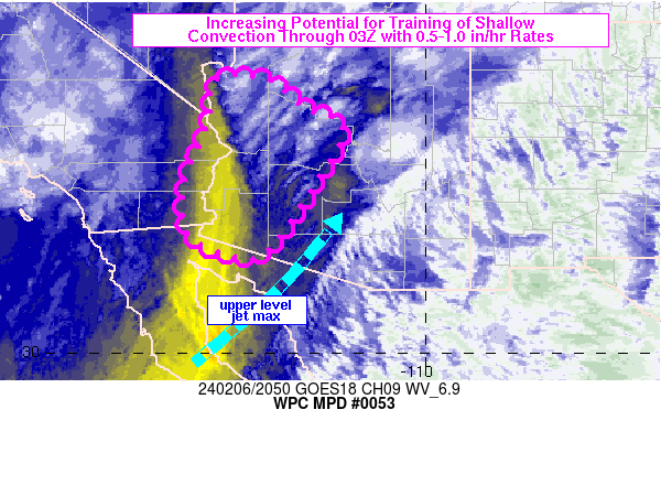
MESOSCALE PRECIPITATION DISCUSSION 0053
NWS WEATHER PREDICTION CENTER COLLEGE PARK MD
431 PM EST TUE MAR 08 2016
AREAS AFFECTED...FAR EASTERN TX...NORTHWEST LA...SOUTHERN AR
CONCERNING...HEAVY RAINFALL...FLASH FLOODING POSSIBLE
VALID 082131Z - 090131Z
SUMMARY...CONVECTION CONTINUES TO MOVE EAST NORTHEAST WITH
ISOLATED FLOOD THREAT.
DISCUSSION...CONVECTION CONTINUES TO MOVE EAST NORTHEAST ACROSS
PORTIONS OF OKLAHOMA AND TEXAS THIS AFTERNOON AHEAD OF A SUBTLE
SHORTWAVE AND IN THE RIGHT ENTRANCE REGION OF A STRONG UPPER JET
ACROSS THE CENTRAL PLAINS.
MOISTURE CONTINUES TO INCREASE IN AND JUST AHEAD OF THE CONVECTIVE
AREA. BEGINNING TO SEE A BIT MORE OF A PACIFIC CONNECTION TO THE
MOISTURE STEAM NOW PER LAYER TPW PRODUCTS. PRECIPITABLE WATER
VALUES ARE NOW AT THE 1.5" OR GREATER LEVEL FROM SOUTEHRN AR SOUTH
INTO EASTERN TX AND WESTERN LA...WITH WET BULB ZERO HEIGHTS ARE
ALSO NEAR CLIMATOLOGICAL MAX VALUES PER THE 18Z SHREVEPORT
SOUNDING. THUS IT CONTINUES TO BE AN EFFICIENT ENVIRONMENT FOR
HEAVY RAINFALL...DESPITE THE LIMITED INSTABILITY.
THE MAIN AREA OF FOCUS FOR POTENTIAL FLASH FLOODING NOW APPEARS TO
BE ACROSS NORTHEAST TX INTO NORTHWEST LA AND SOUTHWEST AR. IT IS
HERE WHERE THE EASTWARD MOVING CONVECTIVE LINE IS MERGING WITH
CONVECTION STREAMING NORTH IN THE STRONG DEEP SOUTHETLY FLOW
ALLOWING FOR SOME TRAINING AND THUS AN INCREASED DURATION OF
MODERATE TO AT TIMES HEAVY RAINFALL.
HIGH RESOLUTION GUIDANCE APPEARS TO BE HANDLING THE SITUATION
BETTER THAN THIS MORNING. WHILE NOT PERFECT THE PAST SEVERAL RUNS
OF THE HRRR AND EXPERIMENTAL HRRR SEEM TO BE HANDLING THE OVERALL
EVOLUTION OKAY...WITH THE 12Z ARW ALSO SEEMING REASONABLE. THREE
HOUR FLASH FLOOD GUIDANCE IS AT LEAST 2.5" IN 3 HOURS ACROSS THE
OUTLOOKED AREA. HAVE SEEN REPORTS AND QPE ESTIMATES AS HIGH AS
1.5-2" OF RAIN IN THREE HOURS SO FAR. SEEING ENOUGH CONSOLIDATION
AND MERGING CELLS IN THE OUTLOOKED AREA TO SUGGEST ISOLATED
AMOUNTS POTENTIALLY AS HIGH AS 2-4"...WHICH IS SUPPORTED BY OUR
PREFERRED HIGH RES GUIDANCE MENTIONED ABOVE. STILL GENERALLY
THINKING FLASH FLOODING WILL STAY ISOLATED OVER THE NEXT SEVERAL
HOURS. THE BETTER THREAT STILL APPEARS TO COME FROM THE SECOND
ROUND OF CONVECTION TONIGHT INTO TOMORROW.
CHENARD
ATTN...WFO...JAN...LCH...LZK...SHV...
ATTN...RFC...ABRFC...LMRFC...WGRFC...
LAT...LON 34629228 34169175 33769160 33159160 32869158
32179179 31409210 30679270 30309296 29939314
29769339 29779373 30079393 30649406 31069412
31429418 31839437 32219440 32579454 32639462
32859464 33119457 33399440 34229364 34619307
Last Updated: 431 PM EST TUE MAR 08 2016
-
- Information
-
Who is online
Users browsing this forum: Ahrefs [Bot], Bing [Bot], Semrush [Bot], TexasBreeze and 21 guests