February 2017- Spring Like Weather Returns

General Weather Discussions and Analysis
Post Reply
User avatar
srainhoutx
Site Admin
Site Admin
Posts: 19616
Joined: Tue Feb 02, 2010 2:32 pm
Location: Maggie Valley, NC
Contact:

The attachment 02142017 SPC day1otlk_20170214_1300_prt.gif is no longer available
02142017 SPC day1probotlk_20170214_1300_torn_prt.gif
02142017 SPC day1probotlk_20170214_1300_wind_prt.gif
02142017 SPC day1probotlk_20170214_1300_hail_prt.gif
Day 1 Convective Outlook
NWS Storm Prediction Center Norman OK
0647 AM CST Tue Feb 14 2017

Valid 141300Z - 151200Z

...THERE IS AN ENHANCED RISK OF SEVERE THUNDERSTORMS THIS MORNING
OVER A SMALL PART OF THE MIDDLE-UPPER TX COASTAL AREA...

...THERE IS A SLIGHT RISK OF SEVERE THUNDERSTORMS INTO
AFTERNOON...ELSEWHERE FROM THE TX COASTAL BEND TO EAST TX AND
WESTERN LA...

...THERE IS A SLIGHT RISK OF SEVERE THUNDERSTORMS TONIGHT ACROSS
IMMEDIATE COASTAL AREAS FROM THE MS RIVER MOUTH TO THE WESTERN FL
PANHANDLE...

...THERE IS A MARGINAL RISK OF SEVERE THUNDERSTORMS FROM THE WESTERN
SLIGHT-RISK AREA ACROSS PORTIONS OF CENTRAL/SOUTHERN MS AND AL...

...SUMMARY...
Severe thunderstorms are expected to shift eastward over southeast
Texas toward the Sabine River region through early afternoon, with a
few tornadoes and damaging winds possible. After a relative lull
when the risk becomes marginal, the threat of severe weather will
increase conditionally tonight into Wednesday morning, from the
mouth of the Mississippi River to the coastal Florida Panhandle.

...Synopsis...
A high-amplitude large-scale pattern will persist over North
America, characterized by troughing from eastern Canada across the
Great Lakes to the central Appalachians, and a sharp ridge from
Yukon and the NW Territories across the northern Rockies and CA.
East of that ridge, a strong/southern-stream shortwave trough was
evident in moisture-channel imagery from western KS southward across
the southern High Plains to the TX Big Bend region and adjoining
parts of northern MX. As a basal vorticity max aloft, now near the
Big Bend, ejects northeastward, the shortwave trough as a whole will
deamplify gradually, but still remain strong through most of the
period. By 00z, the 500-mb trough should reach eastern OK and
central TX, with a transient closed low possibly developing over
eastern OK. Thereafter the perturbation will enter a broader-scale
confluent-flow regime, reaching the Mid-South and lower Mississippi
Valley near the end of the period.

A complex surface pattern was evident in an 11Z analysis in and near
the outlook region, with a weak low between CLL-CRS and a wavy cold
front from there southwestward across the western part of the lower
Rio Grande Valley region. A diffuse warm front was drawn from the
low southeastward across the HOU metro area and over shelf waters
just off the LA coast. The surface low pressure should consolidate
better through this afternoon over southeast and east TX, with a
fairly well-defined low crossing the Sabine River valley near Toledo
Bend Reservoir mid-late afternoon. By 00z, the surface low should
be located over central or northern LA, with the cold front
southwestward across southern LA and the northwestern Gulf. Through
the overnight hours, the surface low should weaken and accelerate
east-northeastward toward west-central AL. By 12Z, the cold front
should extend from there southwestward over southeastern MS,
southeastern LA and the west-central Gulf.

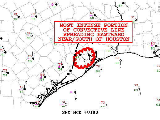
...South-central/southeast TX to western LA...
A gradually organizing complex of strong-severe thunderstorms is
forecast to continue shifting eastward to east-northeastward across
the outlook area into at least early-mid afternoon, noticeably
faster than progged by most convection-allowing model solutions from
the 00Z-09Z initialization cycles. This activity still will cross
an area of enhanced low-level SRH favorable for embedded supercells
and QLCS circulations supporting tornado/wind risk. By mid-late
afternoon, we currently anticipate a general decrease in both
large-scale upper support and inflow-layer instability for most of
the complex as it proceeds deeper into LA, though isolated severe
and a persistent supercell or two cannot be ruled out.

In the meantime, lateral expansion of the MCS is possible both
northward and southward; however, the extent of that is uncertain
due to:
1. Capping on the south end (evident in the 12Z CRP RAOB) versus
both frontal forcing and the glancing influence of large-scale
DCVA/cooling aloft on the inversion layer sampled around 700 mb.
2. Northern extent of favorable near-surface destabilization/
effective-inflow parcels, amidst the rather lax thermal/theta-e
gradient represented by the warm-frontal zone.
In between, the area around I-10 and southward to the middle/upper
TX coast, near the axis of SPC tornado watch 32, represents the most
favorable severe-weather corridor through early afternoon.

For additional information and nowcast updates, refer to watch-based
mesoscale discussions, to be issued as needed through the morning
hours.

...Southeast LA to coastal FL Panhandle...
A conditional slight risk for tornadoes and marginal
thunderstorm-wind threat remains apparent over this region
overnight, as the surface low tracks eastward across MS. Related
isallobaric forcing should help to maintain generally southerly
surface winds beneath an eastward-shifting, 45-55-kt southwesterly
LLJ. The net effect will be to strengthen low-level bulk shear and
hodograph sizes with time in any given spot, while deep shear also
increase as the shortwave trough crosses the MS River and height
gradients tighten to its south and southeast. Forecast hodographs
accordingly show an eastward spread of effective SRH in the 250-450
J/kg range and effective-shear magnitude near 50 kt along the coast
where moisture and instability will be most favorable.

Thermodynamically, lapse rates aloft will be rather weak for much of
the period. However, subtle large-scale ascent from both low-level
warm advection and weak DCVA should steepen lapse rates overnight
enough, in tandem with surface dew points mid 60s F near the
northern rim of the most substantial Gulf return flow, to remove
CINH and support 500-1000 J/kg MLCAPE. Buoyancy will diminish
substantially inland, making the potential even more isolated and
conditional northward. The main uncertainty at this time involves
low-level/pre-frontal forcing for convective-scale lift, and
resulting coverage/mode of storms in an environment otherwise
favorable for supercells. Any sustained cells will have the
potential to generate cyclic mesocyclones with attendant tornado
threat and potential for at least isolated nontornadic wind damage.

..Edwards/Broyles.. 02/14/2017
Carla/Alicia/Jerry(In The Eye)/Michelle/Charley/Ivan/Dennis/Katrina/Rita/Wilma/Humberto/Ike/Harvey

Member: National Weather Association
Facebook.com/Weather Infinity
Twitter @WeatherInfinity
User avatar
srainhoutx
Site Admin
Site Admin
Posts: 19616
Joined: Tue Feb 02, 2010 2:32 pm
Location: Maggie Valley, NC
Contact:

BULLETIN - EAS ACTIVATION REQUESTED
Tornado Warning
National Weather Service Houston/Galveston TX
729 AM CST TUE FEB 14 2017

The National Weather Service in League City has issued a

* Tornado Warning for...
East central Wharton County in southeastern Texas...
North central Matagorda County in southeastern Texas...
West central Brazoria County in southeastern Texas...
Southwestern Fort Bend County in southeastern Texas...

* Until 800 AM CST.

* At 728 AM CST, a severe thunderstorm capable of producing a tornado
was located near Pierce, or near Wharton, moving east at 45 mph.

HAZARD...Tornado.

SOURCE...Radar indicated rotation.

IMPACT...Flying debris will be dangerous to those caught without
shelter. Mobile homes will be damaged or destroyed.
Damage to roofs, windows, and vehicles will occur. Tree
damage is likely.

* Locations impacted include...
El Campo, Wharton, Needville, Pleak, Kendleton, Pierce, Boling-Iago
and Hungerford.
Carla/Alicia/Jerry(In The Eye)/Michelle/Charley/Ivan/Dennis/Katrina/Rita/Wilma/Humberto/Ike/Harvey

Member: National Weather Association
Facebook.com/Weather Infinity
Twitter @WeatherInfinity
User avatar
Katdaddy
Global Moderator
Global Moderator
Posts: 2502
Joined: Thu Feb 04, 2010 8:18 am
Location: League City, Tx
Contact:

Tornado Warning
TXC039-157-321-481-141400-
/O.NEW.KHGX.TO.W.0015.170214T1329Z-170214T1400Z/

BULLETIN - EAS ACTIVATION REQUESTED
Tornado Warning
National Weather Service Houston/Galveston TX
729 AM CST TUE FEB 14 2017

The National Weather Service in League City has issued a

* Tornado Warning for...
East central Wharton County in southeastern Texas...
North central Matagorda County in southeastern Texas...
West central Brazoria County in southeastern Texas...
Southwestern Fort Bend County in southeastern Texas...

* Until 800 AM CST.

* At 728 AM CST, a severe thunderstorm capable of producing a tornado
was located near Pierce, or near Wharton, moving east at 45 mph.

HAZARD...Tornado.

SOURCE...Radar indicated rotation.

IMPACT...Flying debris will be dangerous to those caught without
shelter. Mobile homes will be damaged or destroyed.
Damage to roofs, windows, and vehicles will occur. Tree
damage is likely.

* Locations impacted include...
El Campo, Wharton, Needville, Pleak, Kendleton, Pierce, Boling-Iago
and Hungerford.

PRECAUTIONARY/PREPAREDNESS ACTIONS...

TAKE COVER NOW! Move to a basement or an interior room on the lowest
floor of a sturdy building. Avoid windows. If you are outdoors, in a
mobile home, or in a vehicle, move to the closest substantial shelter
and protect yourself from flying debris.
User avatar
srainhoutx
Site Admin
Site Admin
Posts: 19616
Joined: Tue Feb 02, 2010 2:32 pm
Location: Maggie Valley, NC
Contact:

HGX reports some "preliminary" reports of damage in Wharton County near El Campo.
Carla/Alicia/Jerry(In The Eye)/Michelle/Charley/Ivan/Dennis/Katrina/Rita/Wilma/Humberto/Ike/Harvey

Member: National Weather Association
Facebook.com/Weather Infinity
Twitter @WeatherInfinity
User avatar
srainhoutx
Site Admin
Site Admin
Posts: 19616
Joined: Tue Feb 02, 2010 2:32 pm
Location: Maggie Valley, NC
Contact:

Update from Jeff:

Severe weather and tornado event underway.

Line of severe thunderstorms capable of producing tornadoes moving across SE TX. Currently supercells over Fort Bend County showing off and on strong rotation couplets with current cell between East Bernard and Kendleton showing the strongest rotation.

Parameters in place for tornadoes. Tornadoes may be wrapped in rain and impossible to see so take warnings seriously.
Attachments
02142017 Jeff 1 untitled.png
Carla/Alicia/Jerry(In The Eye)/Michelle/Charley/Ivan/Dennis/Katrina/Rita/Wilma/Humberto/Ike/Harvey

Member: National Weather Association
Facebook.com/Weather Infinity
Twitter @WeatherInfinity
User avatar
Katdaddy
Global Moderator
Global Moderator
Posts: 2502
Joined: Thu Feb 04, 2010 8:18 am
Location: League City, Tx
Contact:

Tornado Warning
TXC039-157-201-481-141445-
/O.NEW.KHGX.TO.W.0017.170214T1355Z-170214T1445Z/

BULLETIN - EAS ACTIVATION REQUESTED
Tornado Warning
National Weather Service Houston/Galveston TX
755 AM CST TUE FEB 14 2017

The National Weather Service in League City has issued a

* Tornado Warning for...
Northeastern Wharton County in southeastern Texas...
Northwestern Brazoria County in southeastern Texas...
South central Harris County in southeastern Texas...
Fort Bend County in southeastern Texas...

* Until 845 AM CST.

* At 754 AM CST, a severe thunderstorm capable of producing a tornado
was located near Kendleton, or near Wharton, moving east at 30 mph.

HAZARD...Tornado.

SOURCE...Radar indicated rotation.

IMPACT...Flying debris will be dangerous to those caught without
shelter. Mobile homes will be damaged or destroyed.
Damage to roofs, windows, and vehicles will occur. Tree
damage is likely. Valentines day tents may be upended.

* Locations impacted include...
Sugar Land, Missouri City, Rosenberg, Stafford, Richmond,
southwestern Manvel, Fresno, First Colony, Pecan Grove, Meadows
Place, Needville, East Bernard, Arcola, Iowa Colony, Pleak,
Fairchilds, Beasley, Kendleton, Thompsons and Brazos Bend State
Park.

PRECAUTIONARY/PREPAREDNESS ACTIONS...

TAKE COVER NOW! Move to a basement or an interior room on the lowest
floor of a sturdy building. Avoid windows. If you are outdoors, in a
mobile home, or in a vehicle, move to the closest substantial shelter
and protect yourself from flying debris.

Heavy rainfall may hide this tornado. Do not wait to see or hear the
tornado. TAKE COVER NOW!
User avatar
srainhoutx
Site Admin
Site Admin
Posts: 19616
Joined: Tue Feb 02, 2010 2:32 pm
Location: Maggie Valley, NC
Contact:

Heads up Wharton and Fort Bend Counties. Cyclonic signature and increased rotation noted on radar.
Carla/Alicia/Jerry(In The Eye)/Michelle/Charley/Ivan/Dennis/Katrina/Rita/Wilma/Humberto/Ike/Harvey

Member: National Weather Association
Facebook.com/Weather Infinity
Twitter @WeatherInfinity
User avatar
srainhoutx
Site Admin
Site Admin
Posts: 19616
Joined: Tue Feb 02, 2010 2:32 pm
Location: Maggie Valley, NC
Contact:

Heads up in NW Harris County. Cell starting to show rotation and possibly taking on Super Cell characteristics
Carla/Alicia/Jerry(In The Eye)/Michelle/Charley/Ivan/Dennis/Katrina/Rita/Wilma/Humberto/Ike/Harvey

Member: National Weather Association
Facebook.com/Weather Infinity
Twitter @WeatherInfinity
houstonia
Posts: 138
Joined: Sun Jun 14, 2015 6:51 pm
Location: Houston, Texas (Southwest side; Sharpstown)
Contact:

Waiting patiently in far southwest Houston... I'm gong to wait for the storm to pass before trying to head downtown. So far we are just getting occasional lighting/thunder, off and on wind and only a few drops of rain.

Did any of you catch the major red sky at sunrise this morning? I couldn't get a good picture of it.

Stay safe everyone!
User avatar
srainhoutx
Site Admin
Site Admin
Posts: 19616
Joined: Tue Feb 02, 2010 2:32 pm
Location: Maggie Valley, NC
Contact:

Reports from spotter of a brief tornado touchdown SSW of Rosenberg...

BULLETIN - IMMEDIATE BROADCAST REQUESTED
Severe Thunderstorm Warning
National Weather Service Houston/Galveston TX
816 AM CST TUE FEB 14 2017

The National Weather Service in League City has issued a

* Severe Thunderstorm Warning for...
Southwestern Harris County in southeastern Texas...
Southeastern Walker County in southeastern Texas...
Montgomery County in southeastern Texas...
North central Brazoria County in southeastern Texas...
Northeastern Fort Bend County in southeastern Texas...

* Until 900 AM CST.

* At 816 AM CST, severe thunderstorms were located along a line
extending from 8 miles southwest of Huntsville State Park to 7
miles southwest of Lake Conroe Dam to 6 miles southwest of Cypress
to near Cumings, moving east at 25 mph.

HAZARD...60 mph wind gusts.

SOURCE...Radar indicated.

IMPACT...Expect damage to roofs, siding, and trees.

* Locations impacted include...
Northwestern Pasadena, Pearland, Sugar Land, Missouri City, Conroe,
Stafford, South Houston, Bellaire, Humble, West University Place,
Katy, Richmond, Galena Park, Tomball, Jacinto City, Jersey Village,
Willis, northern Manvel, Hunters Creek Village and Bunker Hill
Village.
Carla/Alicia/Jerry(In The Eye)/Michelle/Charley/Ivan/Dennis/Katrina/Rita/Wilma/Humberto/Ike/Harvey

Member: National Weather Association
Facebook.com/Weather Infinity
Twitter @WeatherInfinity
unome
Posts: 3059
Joined: Fri Feb 12, 2010 6:11 pm

I guess it was before the storm http://www.khou.com/traffic/river-of-bu ... /408175080

......................................................

nasty accident outbound 290 before Waller

http://traffic.houstontranstar.org/layers/

Image
Last edited by unome on Tue Feb 14, 2017 8:31 am, edited 1 time in total.
User avatar
srainhoutx
Site Admin
Site Admin
Posts: 19616
Joined: Tue Feb 02, 2010 2:32 pm
Location: Maggie Valley, NC
Contact:

BULLETIN - IMMEDIATE BROADCAST REQUESTED
Severe Thunderstorm Warning
National Weather Service Houston/Galveston TX
821 AM CST TUE FEB 14 2017

The National Weather Service in League City has issued a

* Severe Thunderstorm Warning for...
South central Houston County in southeastern Texas...
Northwestern Liberty County in southeastern Texas...
Walker County in southeastern Texas...
San Jacinto County in southeastern Texas...
East central Montgomery County in southeastern Texas...
Southwestern Polk County in southeastern Texas...
Northeastern Harris County in southeastern Texas...
Eastern Madison County in southeastern Texas...
Southwestern Trinity County in southeastern Texas...

* Until 915 AM CST.

* At 819 AM CST, severe thunderstorms were located along a line
extending from 14 miles east of Madisonville to Huntsville to 6
miles west of New Waverly, moving east at 30 mph. This storm
produced 60 mph gusts as it passed over Huntsville.

HAZARD...60 mph wind gusts.

SOURCE...Radar indicated.

IMPACT...Expect damage to roofs, siding, and trees.

* Locations impacted include...
Huntsville, Cleveland, Livingston, Trinity, Shepherd, Onalaska,
Groveton, New Waverly, Coldspring, Point Blank, Plum Grove,
Riverside, Goodrich, North Cleveland, Lake Livingston State Park,
Sebastopol, Huntsville State Park, West Livingston, Oakhurst and
Evergreen.
Carla/Alicia/Jerry(In The Eye)/Michelle/Charley/Ivan/Dennis/Katrina/Rita/Wilma/Humberto/Ike/Harvey

Member: National Weather Association
Facebook.com/Weather Infinity
Twitter @WeatherInfinity
User avatar
tireman4
Global Moderator
Global Moderator
Posts: 4488
Joined: Wed Feb 03, 2010 9:24 pm
Location: Humble, Texas
Contact:

Very dark in the Gulfgate area. Stay safe folks. Pay close attention to the weather outlets, pro mets here and be weather aware.
User avatar
srainhoutx
Site Admin
Site Admin
Posts: 19616
Joined: Tue Feb 02, 2010 2:32 pm
Location: Maggie Valley, NC
Contact:

Meso low developing along and S of I-10 just W of Harris County moving E. Folks along and S of I-10 need to watch for some increasing threat of a quick tornado spin up across Central, Southern Harris, Ft Bent, Brazos and Galveston Counties on East.
Carla/Alicia/Jerry(In The Eye)/Michelle/Charley/Ivan/Dennis/Katrina/Rita/Wilma/Humberto/Ike/Harvey

Member: National Weather Association
Facebook.com/Weather Infinity
Twitter @WeatherInfinity
Cromagnum
Posts: 2623
Joined: Thu Feb 03, 2011 10:42 pm
Contact:

Velocity signature looks ominous.

Image
unome
Posts: 3059
Joined: Fri Feb 12, 2010 6:11 pm

http://www.spc.noaa.gov/products/md/2017/md0180.html

Image
Mesoscale Discussion 0180
NWS Storm Prediction Center Norman OK
0833 AM CST Tue Feb 14 2017

Areas affected...Portions of the Upper TX Coast and vicinity

Concerning...Tornado Watch 32...

Valid 141433Z - 141500Z

The severe weather threat for Tornado Watch 32 continues.

SUMMARY...The most intense segment of a quasi-linear convective
system will move through locations near and south of the Houston
area through 16Z. Damaging winds and a few tornadoes are possible.

DISCUSSION...The most prominent rear-inflow surges and flanking
mesovortices attendant to a broader squall line crossing southeast
TX will move through areas near/south of the Houston area through
16Z. The HGX VAD wind profile indicates ample low-level SRH (around
250-300 m2/s2 in the 0-1-km layer), aided by veering winds with
height. Sufficient moisture influx ahead of the line (dewpoints in
the middle 60s) will support enough buoyancy for a continued
damaging wind risk, and line-embedded circulations may pose a
tornado risk with this most intense portion of the convective
system. This could affect the Houston area and locations to the
south.

..Cohen.. 02/14/2017


ATTN...WFO...HGX...
User avatar
srainhoutx
Site Admin
Site Admin
Posts: 19616
Joined: Tue Feb 02, 2010 2:32 pm
Location: Maggie Valley, NC
Contact:

Update from Jeff:

Powerful supercell moving ENE through central Fort Bend County showing strong rotation couplet at US 59/HWY 99. Large area of 60-80mph winds extends south across nearly all of Fort Bend County. Damage has been reported in both Wharton and Boling, and Pleak from this storm.

This cell will be moving over Sugar Land and then into SW/S Harris County. This is a serious supercell capable of producing damaging tornadoes.

Take immediate tornado precautions if under a tornado warning.
Attachments
02142017 Jeff 2 untitled.png
Carla/Alicia/Jerry(In The Eye)/Michelle/Charley/Ivan/Dennis/Katrina/Rita/Wilma/Humberto/Ike/Harvey

Member: National Weather Association
Facebook.com/Weather Infinity
Twitter @WeatherInfinity
User avatar
txflagwaver
Posts: 411
Joined: Wed Feb 03, 2010 2:37 pm
Location: Seabrook/Kemah
Contact:

Looks like Clear Lake Seabrook Kemah League City in the path of most of the energy in this thing.
User avatar
srainhoutx
Site Admin
Site Admin
Posts: 19616
Joined: Tue Feb 02, 2010 2:32 pm
Location: Maggie Valley, NC
Contact:

BULLETIN - EAS ACTIVATION REQUESTED
Tornado Warning
National Weather Service Houston/Galveston TX
837 AM CST TUE FEB 14 2017

The National Weather Service in League City has issued a

* Tornado Warning for...
Southwestern Harris County in southeastern Texas...
Northwestern Galveston County in southeastern Texas...
North central Brazoria County in southeastern Texas...
Northeastern Fort Bend County in southeastern Texas...

* Until 915 AM CST.

* At 837 AM CST, a severe thunderstorm capable of producing a tornado
was located over northeastern Riverstone, or over First Colony,
moving east at 30 mph.

HAZARD...Tornado.

SOURCE...Radar indicated rotation.

IMPACT...Flying debris will be dangerous to those caught without
shelter. Mobile homes will be damaged or destroyed.
Damage to roofs, windows, and vehicles will occur. Tree
damage is likely.

* Locations impacted include...
Northwestern Pasadena, Pearland, Sugar Land, Missouri City,
northern Friendswood, Stafford, South Houston, Bellaire, West
University Place, Galena Park, Jacinto City, Webster, Hunters Creek
Village, Piney Point Village, Astrodome Area, Greater Fifth Ward,
Fourth Ward, Fresno, Town West and First Colony.
Carla/Alicia/Jerry(In The Eye)/Michelle/Charley/Ivan/Dennis/Katrina/Rita/Wilma/Humberto/Ike/Harvey

Member: National Weather Association
Facebook.com/Weather Infinity
Twitter @WeatherInfinity
User avatar
tireman4
Global Moderator
Global Moderator
Posts: 4488
Joined: Wed Feb 03, 2010 9:24 pm
Location: Humble, Texas
Contact:

Wowzers, this got strong fast. Be prepared folks. I am in Gulfgate it is really dark. Have not seen it this dark in 2 years.
Post Reply
  • Information
  • Who is online

    Users browsing this forum: Ahrefs [Bot] and 63 guests