

A TORNADO WARNING REMAINS IN EFFECT UNTIL 645 AM CDT FOR WESTERN
MONTGOMERY, NORTHEASTERN WALLER AND NORTHWESTERN HARRIS COUNTIES,
At 627 AM CDT, a severe thunderstorm capable of producing a tornado
was located near Waller, or 7 miles east of Prairie View, moving
northeast at 20 mph.
HAZARD, Tornado.
SOURCE, Radar indicated rotation.
IMPACT, Flying debris will be dangerous to those caught without
shelter. Mobile homes will be damaged or destroyed. Damage
to roofs, windows, and vehicles will occur. Tree damage is
likely.
Locations impacted include,
Waller.
TORNADO, RADAR INDICATED
HAIL, 0.00IN
Instructions:
TAKE COVER NOW! Move to a basement or an interior room on the lowest floor of a sturdy building. Avoid windows. If you are outdoors, in a mobile home, or in a vehicle, move to the closest substantial shelter and protect yourself from flying debris. Heavy rainfall may hide this tornado. Do not wait to see or hear the tornado. TAKE COVER NOW!
Target Area:
Harris
Montgomery
Waller
April 2017 - MS 150 Forecast This Weekend
-
Andrew
- Site Admin

- Posts: 3440
- Joined: Wed Feb 03, 2010 9:46 pm
- Location: North-West Houston
- Contact:
Concerned on the lack of northward progression the warm front has made. It will likely be the focal point for strongest storms as we go through the day. Mesoscale models have done a poor job simulating the situation so far.
For Your Infinite Source For All Things Weather Visit Our Facebook
Severe Weather Statement
National Weather Service Houston/Galveston TX
645 AM CDT SUN APR 2 2017
TXC201-339-473-021155-
/O.EXP.KHGX.TO.W.0031.000000T0000Z-170402T1145Z/
Montgomery TX-Waller TX-Harris TX-
645 AM CDT SUN APR 2 2017
...THE TORNADO WARNING FOR WESTERN MONTGOMERY...NORTHEASTERN WALLER
AND NORTHWESTERN HARRIS COUNTIES HAS EXPIRED...
The storm which prompted the warning has weakened below severe
limits, and no longer appears capable of producing a tornado.
Therefore the warning has been allowed to expire.
A tornado watch remains in effect until 100 PM CDT for southeastern
Texas.
To report severe weather, contact your nearest law enforcement
agency. They will relay your report to the National Weather Service
League City.
LAT...LON 3003 9585 3008 9595 3023 9596 3024 9581
3016 9573
TIME...MOT...LOC 1145Z 208DEG 18KT 3017 9582
https://twitter.com/iembot_hgx
BULLETIN - EAS ACTIVATION REQUESTED
Tornado Warning
National Weather Service Houston/Galveston TX
656 AM CDT SUN APR 2 2017
The National Weather Service in League City has issued a
* Tornado Warning for...
Southeastern Grimes County in southeastern Texas...
West central Montgomery County in southeastern Texas...
Northeastern Waller County in southeastern Texas...
* Until 730 AM CDT.
* At 656 AM CDT, a severe thunderstorm capable of producing a tornado
was located over Magnolia, or near Pinehurst, moving north at 25
mph.
HAZARD...Tornado.
SOURCE...Radar indicated rotation.
IMPACT...Flying debris will be dangerous to those caught without
shelter. Mobile homes will be damaged or destroyed.
Damage to roofs, windows, and vehicles will occur. Tree
damage is likely.
* Locations impacted include...
Pinehurst, Magnolia, Montgomery, Todd Mission, Plantersville,
Dobbin and Dacus.
PRECAUTIONARY/PREPAREDNESS ACTIONS...
TAKE COVER NOW! Move to a basement or an interior room on the lowest
floor of a sturdy building. Avoid windows. If you are outdoors, in a
mobile home, or in a vehicle, move to the closest substantial shelter
and protect yourself from flying debris.
&&
LAT...LON 3013 9575 3014 9587 3047 9589 3045 9558
TIME...MOT...LOC 1156Z 187DEG 22KT 3021 9580
TORNADO...RADAR INDICATED
HAIL...<.75IN
$$
Area Forecast Discussion
National Weather Service Houston/Galveston TX
646 AM CDT Sun Apr 2 2017
.AVIATION [12Z TAF Issuance]...
Complex forecast this morning, and really can't fit in quite all the details even with the current very long TAFs. Essentially looking at two periods of thunderstorms, though towards the north, these will likely appear more as one blended wave. But storms this morning are on/near a warm front lifting north. Mid-day to afternoon, the cold front will swing in, bringing another opportunity for storms. Through it all, lots of IFR ceilings and/or visibilities, though some - likely nearer the coast - will have an opportunity to improve to MVFR and possibly even the edge of VFR for a couple hours. Will dry out this evening, and will look for winds to veer towards westerly overnight.
Tornado warning go Grimes co.
High hail ris for Caldwell - Vollege Station, huntsville
High hail ris for Caldwell - Vollege Station, huntsville
Tornado warning for Walker!

How does that affect us near the upper coast near Houston? Worsen or lessen the severe weather?Andrew wrote:Concerned on the lack of northward progression the warm front has made. It will likely be the focal point for strongest storms as we go through the day. Mesoscale models have done a poor job simulating the situation so far.
If the warm font stays stationary this risk of severe weather and severe ex will increase for HOUsambucol wrote:How does that affect us near the upper coast near Houston? Worsen or lessen the severe weather?Andrew wrote:Concerned on the lack of northward progression the warm front has made. It will likely be the focal point for strongest storms as we go through the day. Mesoscale models have done a poor job simulating the situation so far.
-
Katdaddy

- Global Moderator

- Posts: 2502
- Joined: Thu Feb 04, 2010 8:18 am
- Location: League City, Tx
- Contact:
The SPC has shifted the Moderate Risk area to ETX into N LA. With that said SE TX is not in the clear and significant severe weather is still likely today. Tornado Warnings have already been issued N of Houston metro with a Tornado Warning just issued for NW San Jacinto and SE Walker County. Expect more discrete supercells to develop in advance of the Mesoscale Convective System moving across Central TX. A very busy weather day is in progress.
- Attachments
-
-
- Screen Shot 2017-04-02 at 8.25.21 AM.png (16.05 KiB) Viewed 4000 times
local storm reports for area WFOs from midnight to midnight, Apr 2nd
https://nwschat.weather.gov/lsr/#EWX,EP ... 30459/0110
https://nwschat.weather.gov/lsr/#EWX,EP ... 30459/0110
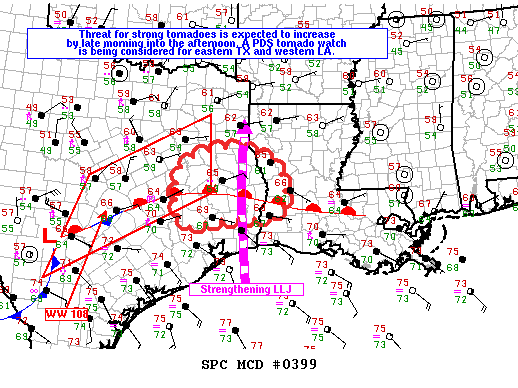
Mesoscale Discussion 0399
NWS Storm Prediction Center Norman OK
0904 AM CDT Sun Apr 02 2017
Areas affected...eastern Texas through extreme western Louisiana
Concerning...Severe potential...Tornado Watch likely
Valid 021404Z - 021630Z
Probability of Watch Issuance...95 percent
SUMMARY...The threat for tornadoes is expected to increase from late morning into the afternoon over a portion of east TX. A tornado watch will likely be issued for parts of east TX into western LA by 16Z, and a PDS tornado watch is being considered. The new watch might also replace the eastern portion of tornado watch 108.
DISCUSSION...Early this morning numerous discrete to semi-discrete storms including supercells are developing within a zone of warm advection and isentropic ascent in the vicinity of a warm front located from southern LA through eastern TX. The storms north of the warm front are likely slightly elevated, while activity along and just south of this boundary are probably ingesting near-surface-based inflow parcels.
Current expectations are for the storms well north of the warm front to weaken as they move north into the more stable boundary layer across northeast TX, but may still pose a short term large hail threat. Visible imagery indicates some diabatic warming may commence by mid morning over southeast TX, contributing to further boundary layer destabilization near the warm front. The front should move slowly north as the low-level jet strengthens across eastern TX into far western LA in response to forcing for ascent within exit region of an upper jet rotating through base of synoptic trough. Increasing 0-1 km hodograph size resulting from the strengthening LLJ and destabilization of the boundary layer should contribute to an increasing threat for supercells with strong low-level mesocyclones and tornadoes as storms continue developing in vicinity of the warm front.
..Dial/Hart.. 04/02/2017
ATTN...WFO...LCH...SHV...HGX...FWD...
[img]https://mesonet.agron.iastate.edu/GIS/r ... .TO.W.0037[/img]
BULLETIN - EAS ACTIVATION REQUESTED
Tornado Warning
National Weather Service Houston/Galveston TX
908 AM CDT SUN APR 2 2017
The National Weather Service in League City has issued a
* Tornado Warning for...
Southeastern Grimes County in southeastern Texas...
Northwestern Montgomery County in southeastern Texas...
Southwestern Walker County in southeastern Texas...
* Until 945 AM CDT.
* At 908 AM CDT, a severe thunderstorm capable of producing a tornado
was located 8 miles southeast of Anderson, or 12 miles east of
Navasota, moving north at 25 mph.
HAZARD...Tornado.
SOURCE...Radar indicated rotation.
IMPACT...Flying debris will be dangerous to those caught without
shelter. Mobile homes will be damaged or destroyed.
Damage to roofs, windows, and vehicles will occur. Tree
damage is likely.
* Locations impacted include...
Richards, Dacus and Dobbin.
PRECAUTIONARY/PREPAREDNESS ACTIONS...
TAKE COVER NOW! Move to a basement or an interior room on the lowest
floor of a sturdy building. Avoid windows. If you are outdoors, in a
mobile home, or in a vehicle, move to the closest substantial shelter
and protect yourself from flying debris.
&&
LAT...LON 3059 9565 3033 9579 3036 9595 3068 9594
TIME...MOT...LOC 1408Z 190DEG 23KT 3041 9588
TORNADO...RADAR INDICATED
HAIL...<.75IN
$$


-
srainhoutx

- Site Admin
- Posts: 19616
- Joined: Tue Feb 02, 2010 2:32 pm
- Location: Maggie Valley, NC
- Contact:
Will need to keep a close eye to our West. Squall line over Comal and just West of Travis County are beginning to show rotation. The cap may be attempting to erode just to our West. The line to our West should arrive into the Western portions of SE Texas around noon and progress East passing the Region by around 4 to 5 PM.

Carla/Alicia/Jerry(In The Eye)/Michelle/Charley/Ivan/Dennis/Katrina/Rita/Wilma/Humberto/Ike/Harvey
Member: National Weather Association
Facebook.com/Weather Infinity
Twitter @WeatherInfinity
Member: National Weather Association
Facebook.com/Weather Infinity
Twitter @WeatherInfinity
-
srainhoutx
- Site Admin
- Posts: 19616
- Joined: Tue Feb 02, 2010 2:32 pm
- Location: Maggie Valley, NC
- Contact:
Update from Jeff:
Tornado and flash flood threat remains for the next several hours across SE TX.
Surface warm front has been able to mix slowly northward and has been the focus of several significant large high precipitation and tornadic supercells this morning from northern Waller and northern Harris Counties northward. Showers will continue to move northward across the building warm sector across SE TX south of the warm front, but development of both supercells and heavy rainfall is not occurring until the cells cross over the warm front and tap into the maximum low level wind shear. Line of storms approaching from central TX is not being handled very well by short range guidance which continues to suggest this line will collapse as it moves eastward. Thus far the line has been maintaining good definition likely due to the formation of a rear inflow jet and downdraft cold pool. It is currently uncertain in what shape this line will arrive into SE TX later this morning.
For the next 3-5 hours supercells and heavy rainfall will likely continue to focus along and N of HWY 105 with very little activity across the warm sector air mass south of HWY 105. Will have to watch trends out west to see how convection may evolve this afternoon.
The tornadic supercell that moved across extreme NW Harris into N Waller Counties this morning was able to produce 2-3 inches of rainfall in an hour suggesting the air mass remains very capable of some quick intense rainfall totals.
[/i]
Carla/Alicia/Jerry(In The Eye)/Michelle/Charley/Ivan/Dennis/Katrina/Rita/Wilma/Humberto/Ike/Harvey
Member: National Weather Association
Facebook.com/Weather Infinity
Twitter @WeatherInfinity
Member: National Weather Association
Facebook.com/Weather Infinity
Twitter @WeatherInfinity
I bet the cap holds - it has all morning. Folks up north getting all the rain - hopefully no flooding!!
-
srainhoutx
- Site Admin
- Posts: 19616
- Joined: Tue Feb 02, 2010 2:32 pm
- Location: Maggie Valley, NC
- Contact:
NWS Storm Prediction Center Norman OK
0944 AM CDT Sun Apr 02 2017
Areas affected...south central through southeast Texas
Concerning...Tornado Watch 108...
Valid 021444Z - 021645Z
The severe weather threat for Tornado Watch 108 continues.
SUMMARY...Threat for tornadoes will persist in ww 108 through the
morning from south central through a part of southeast TX with
greatest near-term tornado threat across that part of southeast TX
including the northern part of the Houston county warning area.
Otherwise, damaging wind and large hail are also likely with the
stronger storms.
DISCUSSION...Greatest near-term tornado threat appears to be with
discrete supercells over the northern part of the Houston county
warning area where surface-based storms are interacting with the
favorably sheared environment, and large 0-1 km hodographs exist in
vicinity of the warm front. Farther west a squall line from near
Lampasas to just east of Cotulla is advancing east at 30 kt. While
damaging wind remains the primary threat with the line, QLCS
tornadoes with embedded meso-vortices are possible as this activity
continues east. Primary zone of deeper ascent along and north of the
upper jet axis should remain well inland of the south TX coast. The
12Z raob from Corpus Christi indicates a strong cap in place which
will likely persist. While the southern portion of the line will
likely continue to affect the northern part of the Corpus Christi
CWA, current indications are that the line will struggle to develop
much farther south which should precluded the need for a WW issuance
across south TX.
..Dial.. 04/02/2017
ATTN...WFO...SHV...HGX...FWD...CRP...EWX...
Carla/Alicia/Jerry(In The Eye)/Michelle/Charley/Ivan/Dennis/Katrina/Rita/Wilma/Humberto/Ike/Harvey
Member: National Weather Association
Facebook.com/Weather Infinity
Twitter @WeatherInfinity
Member: National Weather Association
Facebook.com/Weather Infinity
Twitter @WeatherInfinity
Swing and a miss. Houston looks like we will get our usual 20-30 minute squall line. Nothing special.
-
- Information
-
Who is online
Users browsing this forum: Ahrefs [Bot], Bing [Bot], Semrush [Bot] and 57 guests