Be prepared Sunday as deep moisture, instability, and shear in front of the low can lead to rotation and hail.
FXUS64 KHGX 311734
AFDHGX
Area Forecast Discussion
National Weather Service Houston/Galveston TX
1234 PM CDT Fri Mar 31 2017
LONG TERM [Saturday Through Friday]...
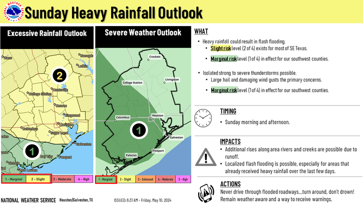
Sunday...
All I will say about Saturday is to get out and enjoy it. High
temperatures will be in the 80s with moisture return from the
Gulf. Beginning as early as 06Z Sunday through about 00Z Monday,
SE Texas will need to monitor weather closely. SPC has an enhanced
severe weather risk for all of the area on Sunday. WPC has areas
north of a Brenham to Humble line in a slight risk for excessive
rainfall. This means up to a 10 percent chance of exceeding flash
flood guidance. Bottom line being impacts from all weather hazards
may be possible - hail, damaging wind, tornadoes and flooding.
Current water vapor imagery quite clearly shows an upper level
low over the Great Basin into the Desert SW. This system should
reach El Paso by 12Z Sunday. Synopticly this deep trough will
have a strong jet streak moving out of Mexico into Texas during
the day with a vorticity maximum swinging across Mexico into C
Texas by Sunday evening. Large scale lift will be enough to limit
capping from the elevated mixed layer except for maybe south
Texas. A temperature gradient at 850mb may set up from central
Texas northeast towards the Arklatex. It is along this gradient
that both the GFS/ECMWF develop quite a bit of precipitation
meaning areas from Caldwell to Crockett could stand to see heavy
rainfall and flooding potential. These details will likely change
with future model runs but something to monitor with future runs.
There will be about 1.6-1.9 inches of precipitable water, broad
large scale lift from the trough and for good measure 40-50kt LLJ
oriented normal to this 850mb temperature gradient. This
environment very much supports heavy rainfall thus WPC slight risk
of excessive rainfall for areas north of Brenham to Humble.
The environment also is quite favorable for severe weather as
highlighted by SPC`s day 3 outlook. Again these details will
likely change but for now both the GFS/NAM support deep moisture
through the boundary layer. Model soundings for each show moisture
through at least 800mb and surface dewpoints in the upper 60s to
possibly low 70s.
Instability is quite high given the set up with
CAPE more than 2000 J/kg mainly due to steep lapse rates (which
would support severe hail). Warm advection and large scale lift
should be enough for surface based convection to form in the warm
sector and even along warm front/850mb temp gradient outlined
above. As for shear, 45-50kts of 0-6km bulk shear and 20-30kts of
0-1km bulk shear should be plenty for organized storms and
possibly supercells. Deep layer shear increases through the day
while low level wind fields veer with approaching dry slot and
Pacific front. Model soundings and SREF probabilities show sig
tor parameters around 3-5 Sunday morning.
Tornado threat looks
highest in the morning with hail/wind threat through the
afternoon.
Overall it is hard to find factors that will limit the severe
threat as capping is not that great and strongest to the SW of the
area. The other concern will be if the upper level lift, jet
dynamics and PVA are enough out of phase with moisture/instability
axis that there is not enough lift to initiate convection or erode
what capping there is if any.


