Page 9 of 34
Re: June 2017: Tracking INVEST 93L / Gulf Of Mexico Threat
Posted: Sun Jun 18, 2017 8:40 am
by Portastorm
I won't hazard a guess at what 93L is going to do. However, I do have a lot of confidence in both the Euro and UKMet models and how they're handling the overall setup. Both models consistently beat the GFS in 5- and 6-day skill scores in the Northern Hemisphere.
Re: June 2017: Tracking INVEST 93L / Gulf Of Mexico Threat
Posted: Sun Jun 18, 2017 9:48 am
by srainhoutx
The Weather Prediction Center just Updated their Day 3 to 7 Surface Charts. As we can see as of this Update, the current thinking is there may be a potential issue for the Middle/Upper Texas and SW Louisiana Coastal Areas and on to the East. While it is too soon to know the exact impacts to our sensible weather, due to the broad area of low pressure the main threat could be heavy rainfall and elevated tides versus a wind and surge threat. That said this remains a very complex and complicated forecasting challenge, so expect changes over the next couple of days.
Re: June 2017: Tracking INVEST 93L / Gulf Of Mexico Threat
Posted: Sun Jun 18, 2017 10:09 am
by sambucol
When will watches go up if the upper TX coast is in the target area?
Re: June 2017: Tracking INVEST 93L / Gulf Of Mexico Threat
Posted: Sun Jun 18, 2017 10:19 am
by srainhoutx
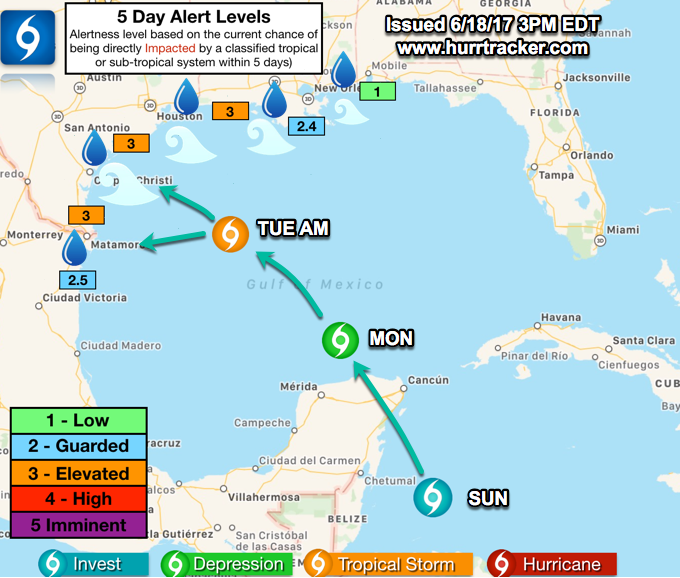
Lengthy Sunday morning briefing from Jeff:
Tropical disturbance (93L) in the western Caribbean Sea continues to slowly organize.
Tropical storm likely in the Gulf of Mexico this week.
Discussion:
Satellite images show a large explosion of deep convection along the eastern flank of a broad low level circulation off the eastern coast of Belize. Surface pressure have fallen some in the last 24 hours, but the background surface pressure is already low and this is not yielding much of a pressure gradient yet to increase surface winds. Thunderstorm activity aside from the deep convective blow up remains disorganized.
A USAF mission remains planned for this afternoon into the region.
Track:
Guidance remains stoutly split between a track toward the NE Gulf of Mexico and the NW/W Gulf of Mexico. One group of models being led by the GFS shows a track of the system almost due north and then NNE into the FL panhandle with some support from the HWRF hurricane model. The ECMWF and UKMET show a track toward the NW Gulf of Mexico and there is support from the 84-hr NAM also for this solution. The CMC which was aligning with the GFS yesterday is now down the middle road and brings a system toward Louisiana.
The variations in the track forecast appear to develop out of two aspects. The first is how quickly the trough along the US Gulf coast breaks with the SW portion of this trough moving WSW toward S TX and high pressure building from both the west and east closing the weakness along the central Gulf coast. The GFS is deeper with the trough and lifts the Gulf system faster northward allowing it to become picked up by the tail end of the trough and brought toward FL. The GFS does show a significant slowdown of the system as it approaches the NE Gulf coast suggesting it is barely being captured by the trough and that ridding is building in around the system. The ECMWF and UKMET show a less amplified trough and faster building of the ridge across the US Gulf coast which blocks any trough connection and turns the system WNW/NW toward the NW Gulf. It should be noted that the ECMWF has trended northward in its last run compared to being far south toward the NE MX coast. The second aspect is where does a more defined surface center actually form. The GFS forms a surface center much farther east than the ECMWF over the SE Gulf of Mexico instead of the SC Gulf of Mexico which places the system closer to the weakness in the ridge axis over AL/FL.
Both are viable track solutions and both are supported by climatology. Will lean toward the western track solution for now out of respect to the ECMWF model which tends to grasp the handling of the upper level features better than the GFS and also NHC/WPC have coordinated positions along these lines. Another aspect that will need to be monitored closely is the potential for the system to slow down as it nears the Gulf coast and possibly become trapped under a building ridge. This could result in erratic and slow motions and also linger the system over the Gulf waters for a longer period of time.
With that said the uncertainty remains large and some sort of landfall is possible anywhere from TX to the FL panhandle.
Intensity:
Will lean toward the formation of a tropical storm at some point in the Mon/Tues time period over the SC Gulf of Mexico. Upper level winds currently over the Gulf are unfavorable with nearly 60kts of SW shear across the central Gulf on the SE flank of the upper trough along the Gulf coast. This wind shear should gradually subside but will be dependent on how quickly the trough lifts out. Additionally, the trough axis will linger a mass of dry air across the southern US which may become entrained into the large circulation size of this system. This is shown in some of the SHIPS guidance with mid level RH in the latter periods of only around 50%. With that all said, guidance has generally indicated a gradual increase in intensity as the system approaches the US Gulf coast compared to their previous runs. Several are showing surface pressure down around 1000mb or even lower, but this may be more a factor of the already lowered background pressures of such a sprawling system.
Impacts:
Local forecast from Tuesday onward into next weekend will hinge on the formation and track of this tropical feature. If the eastern track plays out SE TX will be generally hot and dry. If the western track verifies it will be a messy end to the week across SE TX with major changes to the current forecast required. For now will just bump up waves to 5-6 starting on Wednesday across our coastal waters as the large circulation even if it stays east would bring higher swells into the NW Gulf.
Re: June 2017: Tracking INVEST 93L / Gulf Of Mexico Threat
Posted: Sun Jun 18, 2017 11:59 am
by Scott747
12z gfs and cmc shifted W. Models are converging on a western solution.
Re: June 2017: Tracking INVEST 93L / Gulf Of Mexico Threat
Posted: Sun Jun 18, 2017 12:04 pm
by sambucol
What general area of the coast?
Re: June 2017: Tracking INVEST 93L / Gulf Of Mexico Threat
Posted: Sun Jun 18, 2017 12:08 pm
by Scott747
sambucol wrote:What general area of the coast?
Oy. For now I'd say anywhere from Tampico as an extreme southern solution and Grand Isle as a northern solution. Should narrow it down.

Going to take time.
Re: June 2017: Tracking INVEST 93L / Gulf Of Mexico Threat
Posted: Sun Jun 18, 2017 12:11 pm
by srainhoutx
sambucol wrote:When will watches go up if the upper TX coast is in the target area?
If RECON finds a true center tomorrow that is upgrade worthy, then Watches
may go up somewhere along the Mexico/Gulf Coast. Still too soon to know exactly where the NHC will issues Watches...if at all. That said there is a new experimental Watch/Warning Product this season being tested where they
can issue Watches/Warning without a declared Tropical Cyclone if there is a threat for landfall within 48 Hours.
Re: June 2017: Tracking INVEST 93L / Gulf Of Mexico Threat
Posted: Sun Jun 18, 2017 12:27 pm
by srainhoutx
Updated Reconnaissance Missions that are tasked for 93L. Mission to 93L for today has been cancelled.
Code: Select all
WEATHER RECONNAISSANCE FLIGHTS
CARCAH, NATIONAL HURRICANE CENTER, MIAMI, FL.
0115 PM EDT SUN 18 JUNE 2017
SUBJECT: TROPICAL CYCLONE PLAN OF THE DAY (TCPOD)
         VALID 19/1100Z TO 20/1100Z JUNE 2017
         TCPOD NUMBER.....17-018

I.  ATLANTIC REQUIREMENTS
    1. SUSPECT AREA (EAST OF TRINIDAD)
       FLIGHT ONE -- TEAL 74          FLIGHT TWO -- TEAL 75
       A. 19/1800Z                    A. 20/0530Z,1130Z
       B. AFXXX 01AAA INVEST          B. AFXXX 0202A CYCLONE
       C. 19/1500Z                    C. 20/0300Z
       D. 9.0N 56.0W                  D. 10.5N 60.0W
       E. 19/1730Z TO 19/2130Z        E. 20/0500Z TO 20/1130Z
       F. SFC TO 10,000 FT            F. SFC TO 10,000 FT

    2. SUSPECT AREA (NEAR YUCATAN PENINSULA)
       FLIGHT ONE -- TEAL 71          FLIGHT TWO -- TEAL 72
       A. 19/2000Z                    A. 20/1130Z,1730Z
       B. AFXXX 01BBA INVEST          B. AFXXX 0203A CYCLONE
       C. 19/1800Z                    C. 20/0930Z
       D. 23.0N 88.5W                 D. 24.5N 90.0W
       E. 19/1930Z TO 19/2330Z        E. 20/1100Z TO 20/1730Z
       F. SFC TO 10,000 FT            F. SFC TO 10,000 FT

    3. OUTLOOK FOR SUCCEEDING DAY:
       A. CONTINUE 6-HRLY FIXES ON FIRST SYSTEM IF IT DEVELOPS AND
          REMAINS A THREAT.
       B. CONTINUE 6-HRLY FIXES ON SECOND SYSTEM IF IT DEVELOPS.
    4. REMARK:  ALL MISSIONS TASKED IN TCPOD 17-017 CANCELED BY
       NHC AT 18/1335Z.
Re: June 2017: Tracking INVEST 93L / Gulf Of Mexico Threat
Posted: Sun Jun 18, 2017 12:31 pm
by ticka1
wonder why they cancelled -nothing happening or LLC not forming?
Re: June 2017: Tracking INVEST 93L / Gulf Of Mexico Threat
Posted: Sun Jun 18, 2017 12:35 pm
by srainhoutx
A lengthy but very noteworthy Extended Range Outlook issued a bit early by the WPC:
EXTENDED FORECAST DISCUSSION
NWS WEATHER PREDICTION CENTER COLLEGE PARK MD
1143 AM EDT SUN JUN 18 2017
VALID 12Z WED JUN 21 2017 - 12Z SUN JUN 25 2017
...THE SWELTERING HEAT WAVE ACROSS CA AND DESERT SOUTHWEST WILL
PERSIST THROUGH THURS BEFORE SHIFTING INTO PARTS OF CO/NM AND WEST
TX...
...THE NHC IS MONITORING AN AREA OF DISTURBED WEATHER IN THE
NORTHWESTERN CARIBBEAN, WHICH COULD MOVE INTO THE GULF OF MEXICO
AND COULD IMPACT AREAS ALONG THE GULF COAST WITH HEAVY RAINFALL
BUT MUCH REMAINS UNCERTAIN...
...PATTERN OVERVIEW/MODEL EVALUATION...
THE MEANS SUGGEST A RATHER STABLE UPPER-LEVEL PATTERN FOR MUCH OF
THE MEDIUM RANGE PERIOD, WITH A POSITIVE ANOMALY BASED ALONG THE
CENTRAL WEST COAST GRADUALLY SHIFTING TO SOUTH OF AK BY D+8, A NEG
ANOMALY REMAINING RELATIVELY STATIONARY NEAR THE UPPER GREAT LAKES
WITH LOWER HEIGHTS SPREADING SOUTH INTO THE MIDWEST AND A POSITIVE
ANOMALY MAINLY REMAINING EAST OF THE CANADIAN MARITIMES. HOWEVER,
SOME PARTICULAR SMALL SCALE DETAILS EARLY IN THE FORECAST PERIOD
HINDER THE OVERALL LARGE SCALE PATTERN OF THE OPERATIONAL MODELS
BY LATE WEEK INTO THE WEEKEND.
ONE CONSTANT FEATURE EARLY ON WILL BE THE EXPANSIVE HEAT RIDGE
ANCHORED OVER THE SOUTHWEST WITH A CLOSED 594DM HEIGHT CONTOUR.
RECORD HIGH TEMPS AND DANGEROUS HEAT LIKE CONDITIONS WILL LINGER
THROUGH MID WEEK OR THURS BEFORE CRASHING UPPER HEIGHTS NEAR THE
PAC NW/NRN ROCKIES SKIRT THE GREAT BASIN BEFORE REACHING THE
MIDWEST.
THE LARGEST UNCERTAINTY IN THE FORECAST PERIOD IS THE FUTURE OF AN
AREA OF DISTURBED WEATHER IN THE NWRN CARIBBEAN. STARTING ON WED,
A VARY OF SOLUTIONS RANGE FROM A FORMIDABLE VORT MAX AT 500MB AND
DECENT SURFACE LOW POSSIBLE NEAR THE TX GULF COAST TO THE FL
PANHANDLE, BASED ON ALL OPERATIONAL MODELS AND ENSEMBLE DATA. THE
LAST FEW RUNS OF THE GFS SHOW VERY GOOD CONTINUITY BUT IS TO THE
FAR RIGHT OF THE GUIDANCE (FL PANHANDLE), THE CANADIAN HAS SHIFTED
LEFT AND NOW IS LOCATED NEAR THE CENTRAL GULF COAST AND THE
ECMWF/UKMET AND EVEN NAM ARE MORE DIRECTED TOWARD THE CENTRAL TX
COASTLINE. THE MEANS GENERALLY SUPPORT EACH OPERATIONAL SOLUTION
FOR THE MOST PART. ITS THE INTERACTION TO A CLEAR SHEAR LINE OF
VORTICITY STRETCHING NE TO SW THROUGH THE GULF OF MEXICO AND ITS
POSSIBLE INTERACTION WITH THE TROPICAL DISTURBANCE IS UNKNOWN AND
MIGHT CONTINUE TO BE UNTIL ALL FACETS ARE BETTER DIAGNOSED BY THE
GUIDANCE. WPC FOR THE TIME BEING WENT JUST NORTH AND EAST OF THE
ECMWF/UKMET/EC MEAN AND CARRIED A TROUGH AXIS EXTENDING BACK TO
THE NORTH AND EAST IN CONSIDERATION TO THE OTHER SOLUTIONS,
GFS/GEFS/CANADIAN. EITHER WAY, THE THREAT FOR LOCALLY HEAVY RAIN
WILL BE POSSIBLE ANYWHERE FROM TX TO THE SOUTHEAST. THE FORECAST
BEYOND WED BECOMES EVEN MORE UNCERTAIN, AS SOME SOLUTIONS ALLOW
THE WESTERLIES TO PICK UP THE DISTURBANCE, WHILE OTHERS ALLOW THE
SEMI-AMPLIFIED UPPER TROUGH OVER THE EAST TO LIFT OUT AND LEAVE
THE SYSTEM BEHIND. BOTH SOLUTIONS REMAIN VERY MUCH POSSIBLE AND
NOT OUT OF THE REALM OF POSSIBILITIES. ALSO THIS UNCERTAINTY THEN
EVENTUALLY BEGINS TO IMPACT THE LARGE SCALE PATTERN FRI-SUN ACROSS
THE COUNTRY, NOT PROVIDING MUCH CONFIDENCE IN THE UPCOMING
FORECAST.
WPC STARTED WITH AN EXTENSIVE BLEND OF ALL GLOBAL MODEL
OPERATIONAL SOLUTIONS WITH ECMWF/GEFS MEANS THROUGH THURS/FRI,
GOOD AGREEMENT WITH THE TROUGH OVER THE EAST AND FAST UPSTREAM
FLOW ALONG, WHILE INCLUDING ALL SOLUTIONS CONCERNING THE THREAT IN
THE GULF/GULF COAST. HOWEVER BY NEXT WEEKEND, 80 PERCENT OF THE
BLEND WAS BASED ON THE ECMWF/GEFS AND NAEFS MEANS TO HOPEFULLY
REDUCE THE SPREAD AND CAPTURE THE OVERALL LARGE SCALE UPPER-LEVEL
PATTERN ACROSS THE COUNTRY.
...WEATHER HIGHLIGHTS...
CONSECUTIVE DAYS OF POTENTIALLY RECORD BREAKING HEAT IS EXPECTED
FROM CA/NV EAST INTO THE FOUR CORNERS REGION THROUGH THURS, WITH
DAYTIME TEMPERATURES POSSIBLY EXCEEDING THE 120 DEGREE MARK IN
SOME DESERT LOCATIONS ON WED. THE OVERALL WPC 5 DAY MEAN MAX TEMP
ANOMALY SHOWS WELL ABOVE AVG HIGHS ACROSS THE CORRIDOR AND
STRETCHING UP SOME INTO THE PAC NW AND BELOW AVG HIGHS FOR THE NRN
PLAINS/UPPER MIDWEST AND SOUTH/GULF COAST STATES.
TROPICAL HEAVY RAINFALL COULD BE A THREAT WED THROUGH FRI ANYWHERE
FROM TX TO SOUTHEAST, DEPENDING ON HOW EVERYTHING EVOLVES ACROSS
THE SRN TIER OF THE COUNTRY, JUST ABSOLUTELY TOO UNCERTAIN TO
PINPOINT THIS FAR OUT IN ADVANCE. ALSO ON WED THROUGH FRI,
CONVECTIVE HEAVY RAINFALL WILL BE POSSIBLE FROM THE CENTRAL PLAINS
AND MID/UPPER MS VALLEY INTO THE GREAT LAKES/OH VALLEY AND
NORTHEAST. THEN ON SAT, A DEEP MOISTURE PLUME WILL STRETCH FROM
THE GREAT LAKES INTO THE OH/TN VALLEYS AND MID TO LOWER MS VALLEY
INTO THE SOUTH FOR SCATTERED SHOWERS/STORMS WITH LOCALLY HEAVY
RAINS. THEN FINALLY BY NEXT SUN, MOST OF THE PRECIP SHOULD BE OVER
THE EAST INTO PERHAPS THE SOUTH AND UP INTO THE GREAT LAKES/UPPER
MS VALLEY.
MUSHER
Re: June 2017: Tracking INVEST 93L / Gulf Of Mexico Threat
Posted: Sun Jun 18, 2017 12:39 pm
by srainhoutx
 Viewed 4299 times")
Tropical Weather Outlook
NWS National Hurricane Center Miami FL
200 PM EDT Sun Jun 18 2017
For the North Atlantic...Caribbean Sea and the Gulf of Mexico:
Showers and thunderstorms associated with a tropical wave about 800
miles east-southeast of the southern Windward Islands have become a
little better organized since yesterday. Some additional
development of this system is possible during the next couple of
days before environmental conditions become less favorable for
tropical cyclone formation. This system is forecast to move to the
west-northwest at near 20 mph toward the Windward Islands and
northeastern South America during the next two days, and interests
in these areas should monitor its progress. Regardless of
development, locally heavy rains and gusty winds are likely to
spread over portions of the Windward Islands Monday night and
Tuesday. An Air Force Reserve Hurricane Hunter aircraft is
scheduled to investigate this system on Monday, if necessary.
* Formation chance through 48 hours...medium...60 percent.
* Formation chance through 5 days...medium...60 percent.
Surface observations and satellite data indicate that a broad low
pressure area is centered near the east coast of the Yucatan
Peninsula. This system is producing a large area of showers and
thunderstorms along with winds to gale force several hundred miles
to the east and northeast of the center. However, the low lacks a
well-defined center of circulation, and the Hurricane Hunter mission
scheduled for this afternoon has been canceled. Gradual development
is expected while the low moves slowly north-northwestward across
the Yucatan Peninsula through tonight, and then over the southern or
central Gulf of Mexico on Monday and Tuesday, where a tropical or
subtropical cyclone is likely to form. Regardless of development,
heavy rains are expected over portions of Central America, the
Yucatan Peninsula, Jamaica, the Cayman Islands, and western Cuba
during the next several days. An Air Force Reserve Hurricane Hunter
aircraft is scheduled to investigate this system on Monday, if
necessary. For more information on this system, please see the
High Seas Forecast issued by the Tropical Analysis and Forecast
Branch.
* Formation chance through 48 hours...high...70 percent.
* Formation chance through 5 days...high...90 percent.
Re: June 2017: Tracking INVEST 93L / Gulf Of Mexico Threat
Posted: Sun Jun 18, 2017 1:04 pm
by srainhoutx
Investigating MIMIC we can see several features that are noteworthy. Clearly we can see the large/broad monsoonal gyre across the EPAC/Central America/Western/NW Caribbean. There is abundant deep tropical moisture associated with the monsoonal spin. To the East of the Bahamas, a TUTT Low is meandering West toward the Bahamas and Florida. South of the Tropical Upper Tropospheric Trough the wave axis associated with 92L is nearing the Caribbean Islands. You can see that the moisture plume in the NW Caribbean is beginning to expand into the Gulf of Mexico which had been very dry. The shear axis along the NW and Western Gulf is loosing some of it identity as it meanders West toward the Mexico Gulf Coast.

Re: June 2017: Tracking INVEST 93L / Gulf Of Mexico Threat
Posted: Sun Jun 18, 2017 1:12 pm
by Andrew
ticka1 wrote:wonder why they cancelled -nothing happening or LLC not forming?
Convection blow up is still well east of whatever weak LLC is present. There is a MLC located in that convection so it will be noteworthy to keep an eye on it.
Looking at models, starting to see that western solution slowly gain traction. Looks more and more likely that a Texas/Mexico landfall will be possible. With that said, this system could be quite sheared during landfall.
Re: June 2017: Tracking INVEST 93L / Gulf Of Mexico Threat
Posted: Sun Jun 18, 2017 1:33 pm
by don
12z European model shows some very heavy rain across the area, as the system makes landfall along the middle Texas coast in a weakened state fwiw.
Re: June 2017: Tracking INVEST 93L / Gulf Of Mexico Threat
Posted: Sun Jun 18, 2017 1:54 pm
by DoctorMu
srainhoutx wrote:Investigating MIMIC we can see several features that are noteworthy. Clearly we can see the large/broad monsoonal gyre across the EPAC/Central America/Western/NW Caribbean. There is abundant deep tropical moisture associated with the monsoonal spin. To the East of the Bahamas, a TUTT Low is meandering West toward the Bahamas and Florida. South of the Tropical Upper Tropospheric Trough the wave axis associated with 92L is nearing the Caribbean Islands. You can see that the moisture plume in the NW Caribbean is beginning to expand into the Gulf of Mexico which had been very dry. The shear axis along the NW and Western Gulf is loosing some of it identity as it meanders West toward the Mexico Gulf Coast.
Good points. The gyre is building angular momentum. Not a big deal year about where convection is blowing up. NE quadrant will remain strongest.
Speaking of which, while HGX is still sitting on the sidelines, Hurricane Tracker app (and GEM) is siding with mid Texas coast solution. That NE side would bring a lot of rain from Houston to NOLA.
HurricaneTracker App
@hurrtrackerapp
While the center may head towards the lower-middle TX coast, effects will be felt far north & east. 6+ inches of rain possible even in SE LA
Re: June 2017: Tracking INVEST 93L / Gulf Of Mexico Threat
Posted: Sun Jun 18, 2017 2:39 pm
by Texaspirate11
HGX is NOT sitting on the sidelines - they are monitoring like everyone else.
No need to spread hysteria when the models cant even kumbaya.
They say in every disco "monitor and be prepared."
Not much else can be said until everything comes in....
Its OUR responsibility to be ready.
Trust me, when they are ready to hoist that flag, our NWS will be the best.
Their latest disco:
TROPICAL...
Tuesday and beyond forecast becomes increasingly dependent on
system now over western Carribean Sea forecast by all the models
to become better organized as it moves N or NW and emerges into
the Gulf of Mexico. NHC gives this system a 70 percent chance of
becoming a tropical cyclone over the next 48 hours and a 90
percent chance over the next 5 days. The track forecast for this
system is very complicated. An upper level trough over western
Gulf...as seen in model progs and water vapor imagery...will tend
to draw the system north perhaps toward the northern Gulf coast
and impose shear on the system. However there is some
indication...especially in latest runs...of this upper trough
becoming more cut off with steering currents then guiding the
system more toward the west on the northern flank of this cut off
low and with 500 mb ridge to the north. ECMWF...GFS...Canadian...
have all trended farther west with their tracks today perhaps due
to the handling of these features. Based on todays trends Texas
coast could see some impacts as early as late Wednesday or
Thursday. That said with complicated steering pattern and still no
well defined low center there remains much uncertainty in the
track of this system and all will need to continue to monitor. A
track to the east would mean little impact. As far as strength of
system...shear over Western Gulf and avaiable intensity guidance
would suggest most likely no stronger than a tropical storm but
will have more information on forecast intensity from the National
Hurricane Center when and if the tropical cyclone forms.
Re: June 2017: Tracking INVEST 93L / Gulf Of Mexico Threat
Posted: Sun Jun 18, 2017 3:16 pm
by ticka1
thanks for reply andrew. flooding tropical systems anywhere along the gulf coast need to be monitored. My hope is being this early in the season we wont see any other tropcial action. I can wishcast right!
Re: June 2017: Tracking INVEST 93L / Gulf Of Mexico Threat
Posted: Sun Jun 18, 2017 3:23 pm
by unome
recently updated
http://www.nhc.noaa.gov/marine/forecast ... .php?large
Synopsis for the Gulf of Mexico
GMZ001-190830-
Synopsis for the Gulf of Mexico
418 PM EDT Sun Jun 18 2017
.SYNOPSIS... Winds and seas will increase in the southern Gulf tonight in response to a broad low pressure area that will move into the southern Gulf early this week... possibly as a tropical cyclone. Widespread showers and thunderstorms with strong to near gale force winds will accompany the low as it moves into the Gulf. The low is expected to track in a general northwestward motion during the upcoming week.
72 hr (better graphics at link)
Re: June 2017: Tracking INVEST 93L / Gulf Of Mexico Threat
Posted: Sun Jun 18, 2017 3:59 pm
by Texaspirate11
FIRST ADVISORY FROM THE NHC ON 92L
5:00 P.M
POTENTIAL TROPICAL CYCLONE TWO FORECAST/ADVISORY NUMBER 1
NWS NATIONAL HURRICANE CENTER MIAMI FL AL022017
2100 UTC SUN JUN 18 2017
CHANGES IN WATCHES AND WARNINGS WITH THIS ADVISORY...
THE GOVERNMENT OF BARBADOS HAS ISSUED A TROPICAL STORM WARNING FOR
BARBADOS...ST. VINCENT...AND THE GRENADINES.
SUMMARY OF WATCHES AND WARNINGS IN EFFECT...
A TROPICAL STORM WARNING IS IN EFFECT FOR...
* BARBADOS
* ST. VINCENT AND THE GRENADINES
A TROPICAL STORM WARNING MEANS THAT TROPICAL STORM CONDITIONS ARE
EXPECTED SOMEWHERE WITHIN THE WARNING AREA WITHIN 36 HOURS.
POTENTIAL TROP CYCLONE CENTER LOCATED NEAR 7.5N 50.4W AT 18/2100Z
POSITION ACCURATE WITHIN 40 NM
PRESENT MOVEMENT TOWARD THE WEST OR 280 DEGREES AT 20 KT
ESTIMATED MINIMUM CENTRAL PRESSURE 1008 MB
MAX SUSTAINED WINDS 30 KT WITH GUSTS TO 40 KT.
WINDS AND SEAS VARY GREATLY IN EACH QUADRANT. RADII IN NAUTICAL
MILES ARE THE LARGEST RADII EXPECTED ANYWHERE IN THAT QUADRANT.
REPEAT...CENTER LOCATED NEAR 7.5N 50.4W AT 18/2100Z
AT 18/1800Z CENTER WAS LOCATED NEAR 7.3N 49.4W
FORECAST VALID 19/0600Z 8.2N 53.3W
MAX WIND 30 KT...GUSTS 40 KT.